Showing 668 items matching "george day"
-
 Bendigo Military Museum
Photograph - PHOTOGRAPH WW1, C.1916
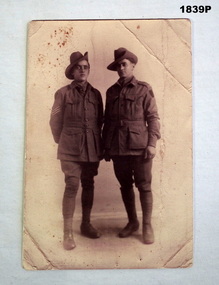
... George Lyonel Henson No 4823 enlisted in the AIF on 8..7.1915 in the 14th reinforcements 6th Batt age 19 years 2 months. Embarked for Egypt 7.3.1916, transfers to 58th Batt 19.5.1916, embarks for France 21.6.1916, promoted to Sgt 3.7.1916, transfers to 57th Batt 29.8.1916. During 1918 he attends Musketry and Corps school totalling 5 weeks. WIA 28.9.1918 GSW’s multiple and DOW’s the same day...George Lyonel Henson No 4823 enlisted in the AIF on 8..7.1915 in the 14th reinforcements 6th Batt age 19 years 2 months. Embarked for Egypt 7.3.1916, transfers to 58th Batt 19.5.1916, embarks for France 21.6.1916, promoted to Sgt 3.7.1916, transfers to 57th Batt 29.8.1916. During 1918 he attends Musketry and Corps school totalling 5 weeks. WIA 28.9.1918 GSW’s multiple and DOW’s the same day ...The card relates to Robert Thomas Heard No 5105, KIA (standing on the right) Refer 1893.2P for his service history and other collection items. The other soldier is George Lyonel Henson No 4823 enlisted in the AIF on 8..7.1915 in the 14th reinforcements 6th Batt age 19 years 2 months. Embarked for Egypt 7.3.1916, transfers to 58th Batt 19.5.1916, embarks for France 21.6.1916, promoted to Sgt 3.7.1916, transfers to 57th Batt 29.8.1916. During 1918 he attends Musketry and Corps school totalling 5 weeks. WIA 28.9.1918 GSW’s multiple and DOW’s the same day. His name and Heards is remembered on the Soldiers Memorial Institute Roll Bendigo.Photo postcard, sepia tone showing two soldiers in uniform standing. Writing on rear in purple pencil.“Dear sister, this is a photo of us both, pretty poor photo. If you have time you might call on George’s mother in Queen St, Mrs Henson 170 Queen St Bendigo”. photographs, postcards, heard -
 Bendigo Military Museum
Booklet - DIARY, 14.10.39 to 30.8.40
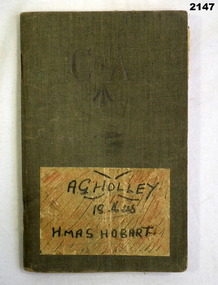
... George Holley No 13556 RAN. Refer 2134 for service history and medals, also 2135.3, 2137, 2148, 2149, 2150. diary personal ran Diary re A.G Holley, small notebook canvas covered, has "C of A" with arrow pointing upwards. A sticker at bottom has hand written "A.G Holley 18 Mess HMAS Hobart". Writing is in pencil and ink, detailed day ...Arthur George Holley No 13556 RAN. Refer 2134 for service history and medals, also 2135.3, 2137, 2148, 2149, 2150. Diary re A.G Holley, small notebook canvas covered, has "C of A" with arrow pointing upwards. A sticker at bottom has hand written "A.G Holley 18 Mess HMAS Hobart". Writing is in pencil and ink, detailed day by day account. Diary begins 14th Oct 1939 to Sat 30th Aug 1940.diary, personal, ran -
 Bendigo Military Museum
Literary work - JOURNAL, NEWSPAPER, 1) June 1977, .2) 1933
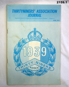
... George Holley No 13556 RAN, HMAS Hobart. Refer 2134 for service history also 2135.3, 2137, 2147. Newspapers journals history .1) "Thirty Niners Association Journal" cardboard covers, centre has circular laurel arrangement, crown at top, in centre 1939, boomerang with Thirty Niners, under Assoc, colours are white, light and dark blue. .2) Newspaper cutting re "Trafalgar Day Preparations" parade of Naval personnel, inspection by Rear Admiral R.C Dalgliesh. ...Items belonged to Arthur George Holley No 13556 RAN, HMAS Hobart. Refer 2134 for service history also 2135.3, 2137, 2147..1) "Thirty Niners Association Journal" cardboard covers, centre has circular laurel arrangement, crown at top, in centre 1939, boomerang with Thirty Niners, under Assoc, colours are white, light and dark blue. .2) Newspaper cutting re "Trafalgar Day Preparations" parade of Naval personnel, inspection by Rear Admiral R.C Dalgliesh.newspapers, journals, history -
 Bendigo Military Museum
Literary work - DIARY, 23.10.41-17.3.42
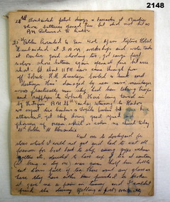
... George Holley No 13556 while serving on HMAS Hobart. This section of diary is part 2 and relates to 2417. Refer also 2134 for service history, 2135.3, 2137. diaries ran personal Diary"A.G Holley RAN" Pink ruled paper written in ink, no front or rear covers, 21 pages of near day by day description of events beginning on 23 Oct 1941-17.3.1942 of HMAS Hobart. ...Diary written by Arthur George Holley No 13556 while serving on HMAS Hobart. This section of diary is part 2 and relates to 2417. Refer also 2134 for service history, 2135.3, 2137.Diary"A.G Holley RAN" Pink ruled paper written in ink, no front or rear covers, 21 pages of near day by day description of events beginning on 23 Oct 1941-17.3.1942 of HMAS Hobart.diaries, ran, personal -
 Bendigo Military Museum
Award - MEDAL SET WW1, Post 1919
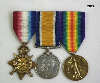
... George Williams (born Melbourne, enlisted Melbourne) No 1608, actually Cuthbert Lodington. He enlisted under an assumed name of an Aunt. Enlisted on 4.12.14 in the 3rd reinforcements to the 6th Batt AIF. Embarked 19.2.15 for Eygpt then Gallipoli. Reported missing 8.5.15, confirmed KIA same day...George Williams (born Melbourne, enlisted Melbourne) No 1608, actually Cuthbert Lodington. He enlisted under an assumed name of an Aunt. Enlisted on 4.12.14 in the 3rd reinforcements to the 6th Batt AIF. Embarked 19.2.15 for Eygpt then Gallipoli. Reported missing 8.5.15, confirmed KIA same day ...George Williams (born Melbourne, enlisted Melbourne) No 1608, actually Cuthbert Lodington. He enlisted under an assumed name of an Aunt. Enlisted on 4.12.14 in the 3rd reinforcements to the 6th Batt AIF. Embarked 19.2.15 for Eygpt then Gallipoli. Reported missing 8.5.15, confirmed KIA same day. Refer 2070P.Medal set, brass plate mounted, set of (3) re G Williams. 1. 1914-15 Star. 2. War Medal 1914-18 3. Victory Medal 1914 - 19"1608 Pte G Williams 6 Bn AIF"medals, military, history -
 Federation University Historical Collection
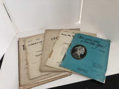
Book, Music Books from Suttons Music
... day...sybil f partridge...blanche ebert seaver...australian music examinations board...pianoforte-grade III...the chappell wonder album of music...slave song...the lass with the delicate air...the bandolero...chorus gentlemen...i'll sing thee songs of araby...jest her way...venetian song...gray days...god's garden...folie bergere...weymouth chimes...un peu d'amour...you'll love me yet...s. coleridge taylor...george...Henry Sutton taught Applied Electricity at the Ballarat School of Mines in 1883 to 1886. music books suttons music Calvary henry vaughan paul rodney enoch and sons herzelied gustav lange j.t. trekell hanover edition the desert song one alone kathryn grayson gordon mcrae otto harbach oscar hammerstein frank mandel sigmund romberg the link divine alfred h. hyatt piccolomini one fine day aria madame butterfly opera r.h elkin giacomo puccini garden of happiness edward lockton daniel wood there never was a pal like you jack o'hagan the bridge vocal duet miss m lindsay mrs j worthington bliss songs my mother taught me anton dvorak blue danube suttons brass band journal johann strauss macushla josephine v rowe dermot macmurrough boosey and co allans music candle in the wind elton john bernie taupin treasure chest of stephen foster songs eddie fisher song folio cindy oh cindy oh my pa-pa anytime I need you now then i'll be happy sweet heartaches dungaree doll im in the mood for love what a wonderful world it would be hermann lohr i heard you singing royden barrie eric coates when you come home fred e weatherly w.h squire lay down your arms anne shelton leon land ake gerhard john m williams and shaylor turners vey first piano book i went to your wedding jessie may robinson patti page mercury records he's got the whole world in his hands geoff love sway quien sera pablo beltran ruiz paul lombard norman gimbel just because the violets kennedy russell edwin ashdown ltd friends of my youth mr w burton christy's minstrels george barker ideal music books poet and peasant melody in f spring song love and devotion the storm nachtstuck rondoletto blue danube waltzes over the waves waltzes nearer my god to thee mignon gavotte warum miss clara butt idle words stephen adams menuetin no. 2 the mill liebestraum tarantelle la matinee menuet la paloma the dove gipsy rondo crescendo chanson triste romance tocatta in a thora john mccormack john harrison ivor foster preclude c# minor beautiful star of heaven sirens song marche militaire fifth nocturne sweet bye and bye turkish patrol valse des fleurs melody of love traumerei a fragment just for to-day sybil f partridge blanche ebert seaver australian music examinations board pianoforte-grade III the chappell wonder album of music slave song the lass with the delicate air the bandolero chorus gentlemen i'll sing thee songs of araby jest her way venetian song gray days god's garden folie bergere weymouth chimes un peu d'amour you'll love me yet s. coleridge taylor george sutton happy-go-lucky pete a very happy foxtrot i know the rose fred hall the prisoners child waltz ballad russ johnston pilgrim's cross h.l d'arcy jaxone frederic n. lohr harper kearton marie vagnolini suttons manuscript music book pianoforte studies public examinations in music light cavalry marche hongroise rondo alla turca moonlight sonata witches flight home sweet home narcissus wedding march sehnsucht joyful peasant les adieux love the pedlar caryl battersby edward german where will the dimple be rosemary clooney bob merrill al hoffman buttons and bows jay livingstone ray evans bob hope glen williams british songs cyril scott cherry ripe the minstrel boy blythe and merry she was by yon bonnie banks all through the night coming thro the rye i'll bid my heart be still classical fragments beethoven's adieu w. millward wake up a calendar of song harold simpson montague f. phillips ain't misbehavin' andy razaf thomas waller harry brooks robert a nelson the ideal manuscript book the riff song it one flower grows alone in your garden ebb tide carl sigman robert maxwell i'm in the mood for love jimmy mchugh dorothy fields muskat ramble edward ory night of stars and night of love tales of hoffmann offenbach the great pretender jimmy parkinson jerry duanne barry frank stan freberg the platters bert visser love is a golden ring rich dehr frank miller terry gilkyson ernie sigley d. trickey four musical cameos gavotte lullaby goblins when children play frank hutchens just a closer walk with thee jimie rodgers west of the wall wayne shanklin toni fisher Collection of music books that were available for purchase at Sutton's Music Music Books from Suttons Music Book ...Henry Sutton is a talented world-wide accepted inventor with inventions relating to the telephone, photography, wireless, cars, motorcycles, and bicycles as well as many more inventions. Henry was also one of four brothers that ran the Sutton's Music Store after the death of their Father Richard Sutton. Henry Sutton taught Applied Electricity at the Ballarat School of Mines in 1883 to 1886.Collection of music books that were available for purchase at Sutton's Musicmusic books, suttons music, calvary, henry vaughan, paul rodney, enoch and sons, herzelied, gustav lange, j.t. trekell, hanover edition, the desert song, one alone, kathryn grayson, gordon mcrae, otto harbach, oscar hammerstein, frank mandel, sigmund romberg, the link divine, alfred h. hyatt, piccolomini, one fine day, aria, madame butterfly opera, r.h elkin, giacomo puccini, garden of happiness, edward lockton, daniel wood, there never was a pal like you, jack o'hagan, the bridge, vocal duet, miss m lindsay, mrs j worthington bliss, songs my mother taught me, anton dvorak, blue danube, suttons brass band journal, johann strauss, macushla, josephine v rowe, dermot macmurrough, boosey and co, allans music, candle in the wind, elton john, bernie taupin, treasure chest of stephen foster songs, eddie fisher song folio, cindy oh cindy, oh my pa-pa, anytime, i need you now, then i'll be happy, sweet heartaches, dungaree doll, im in the mood for love, what a wonderful world it would be, hermann lohr, i heard you singing, royden barrie, eric coates, when you come home, fred e weatherly, w.h squire, lay down your arms, anne shelton, leon land, ake gerhard, john m williams and shaylor turners vey first piano book, i went to your wedding, jessie may robinson, patti page, mercury records, he's got the whole world in his hands, geoff love, sway, quien sera, pablo beltran ruiz, paul lombard, norman gimbel, just because the violets, kennedy russell, edwin ashdown ltd, friends of my youth, mr w burton, christy's minstrels, george barker, ideal music books, poet and peasant, melody in f, spring song, love and devotion, the storm, nachtstuck, rondoletto, blue danube waltzes, over the waves waltzes, nearer my god to thee, mignon gavotte, warum, miss clara butt, idle words, stephen adams, menuetin no. 2, the mill, liebestraum, tarantelle, la matinee, menuet, la paloma, the dove, gipsy rondo, crescendo, chanson triste, romance, tocatta in a, thora, john mccormack, john harrison, ivor foster, preclude c# minor, beautiful star of heaven, sirens song, marche militaire, fifth nocturne, sweet bye and bye, turkish patrol, valse des fleurs, melody of love, traumerei, a fragment, just for to-day, sybil f partridge, blanche ebert seaver, australian music examinations board, pianoforte-grade iii, the chappell wonder album of music, slave song, the lass with the delicate air, the bandolero, chorus gentlemen, i'll sing thee songs of araby, jest her way, venetian song, gray days, god's garden, folie bergere, weymouth chimes, un peu d'amour, you'll love me yet, s. coleridge taylor, george sutton, happy-go-lucky pete a very happy foxtrot, i know the rose, fred hall, the prisoners child, waltz ballad, russ johnston, pilgrim's cross, h.l d'arcy jaxone, frederic n. lohr, harper kearton, marie vagnolini, suttons manuscript music book, pianoforte studies, public examinations in music, light cavalry, marche hongroise, rondo alla turca, moonlight sonata, witches flight, home sweet home, narcissus, wedding march, sehnsucht, joyful peasant, les adieux, love the pedlar, caryl battersby, edward german, where will the dimple be, rosemary clooney, bob merrill, al hoffman, buttons and bows, jay livingstone, ray evans, bob hope, glen williams, british songs, cyril scott, cherry ripe, the minstrel boy, blythe and merry she was, by yon bonnie banks, all through the night, coming thro the rye, i'll bid my heart be still, classical fragments, beethoven's adieu, w. millward, wake up, a calendar of song, harold simpson, montague f. phillips, ain't misbehavin', andy razaf, thomas waller, harry brooks, robert a nelson, the ideal manuscript book, the riff song, it, one flower grows alone in your garden, ebb tide, carl sigman, robert maxwell, i'm in the mood for love, jimmy mchugh, dorothy fields, muskat ramble, edward ory, night of stars and night of love, tales of hoffmann, offenbach, the great pretender, jimmy parkinson, jerry duanne, barry frank, stan freberg, the platters, bert visser, love is a golden ring, rich dehr, frank miller, terry gilkyson, ernie sigley, d. trickey, four musical cameos, gavotte, lullaby, goblins, when children play, frank hutchens, just a closer walk with thee, jimie rodgers, west of the wall, wayne shanklin, toni fisher -
 Marysville & District Historical Society
THE TRIANGLE NEWS-VOL 4 NO 34-26 OCTOBER 1979
... george edwards last service...wirreanda tee shirts...wirreanda ball...wanted...annual meeting...hair dressing salon...bus to oaks day...Marysville & District Historical Society 39 Darwin Street Marysville yarra-valley-and-the-dandenong-ranges marysville victoria australia thanks wirreanda rosters rev george edwards last service wirreanda tee shirts wirreanda ball wanted annual meeting hair dressing salon bus to oaks day happy birthday lions club chariot challenge for sale r.s.l. day floral carpet guides & brownies clearance sale wirreanda jottings marysville cubs anglican news community care centre wanted p/t gardener bonney's footy club presentation night fire brigade member for evelyn daylight savings reminder THE TRIANGLE NEWS-VOL 4 NO 34-26 OCTOBER 1979 ...marysville, victoria, australia, thanks, wirreanda rosters, rev george edwards last service, wirreanda tee shirts, wirreanda ball, wanted, annual meeting, hair dressing salon, bus to oaks day, happy birthday, lions club chariot challenge, for sale, r.s.l. day, floral carpet guides & brownies, clearance sale, wirreanda jottings, marysville cubs, anglican news, community care centre, wanted p/t gardener, bonney's, footy club, presentation night, fire brigade, member for evelyn, daylight savings reminder -
 Orbost & District Historical Society
framed certificate, January 2003
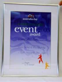
... Day celebrations on 26.1.2003. The veiling of McKillops bridge was a 'Year of the Outback' event. The event was organised by Orbost resident, Sr Helen Barnes RSJ. to show solidarity with rural people. The local community transformed the bridge into "a symbol of communal love and hope", when its sides were draped with hundreds of personal messages. McKillop's Bridge, located high in the Snowy Mountains, is named after George...Day celebrations on 26.1.2003. The veiling of McKillops bridge was a 'Year of the Outback' event. The event was organised by Orbost resident, Sr Helen Barnes RSJ. to show solidarity with rural people. The local community transformed the bridge into "a symbol of communal love and hope", when its sides were draped with hundreds of personal messages. McKillop's Bridge, located high in the Snowy Mountains, is named after George ...This certificate was presented at the East Gippsland Shire Council Australia Day celebrations on 26.1.2003. The veiling of McKillops bridge was a 'Year of the Outback' event. The event was organised by Orbost resident, Sr Helen Barnes RSJ. to show solidarity with rural people. The local community transformed the bridge into "a symbol of communal love and hope", when its sides were draped with hundreds of personal messages. McKillop's Bridge, located high in the Snowy Mountains, is named after George McKillop, a pioneering explorer of the area. The bridge is a vital link for isolated farming communities living beyond the Bonang highway. The Veiling of McKillops Bridge was a significant community event.A large framed certificate. An Australia Day Community Event certificate for January 2003. The frame is silver The certificate has white, green and blue print on a blue background.presented to "Veiling of McKillops Bridge on frame corner AMS by East Gippsland Shie Council signed by Cr P. Bommer (mayor)mckillops-bridge-veiling east-gippsland-shire-council-australia-day -
 Orbost & District Historical Society
Magazine, The Australian Women's weekly, Sept, 1945, September 1 1945
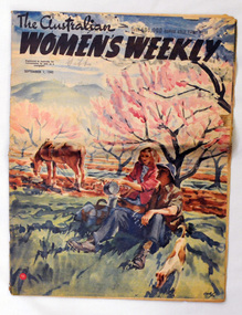
... George Warnecke and the initial dummy was laid out by WEP (William Edwin Pidgeon) who went on to do many famous covers over the next 25 years. It is the most widely read magazine in the history of Australian publishing. During wartime despite printing restrictions, and it began publishing coloured photographic covers. This is an example of anAustralian women's magazine published during WW11.It gives practical advice on needlework / knitting and evidences the widespread interest in contemporary fashion. In doing so it shows what were the fashionable, but broadly affordable, women's and children's clothing styles of their day ...The magazine was started in 1933 by Frank Packer as a weekly publication. The first editor was George Warnecke and the initial dummy was laid out by WEP (William Edwin Pidgeon) who went on to do many famous covers over the next 25 years. It is the most widely read magazine in the history of Australian publishing. During wartime despite printing restrictions, and it began publishing coloured photographic covers.This is an example of anAustralian women's magazine published during WW11.It gives practical advice on needlework / knitting and evidences the widespread interest in contemporary fashion. In doing so it shows what were the fashionable, but broadly affordable, women's and children's clothing styles of their day. These magazines also reflect women's interests.A 32 pp magazine, titled The Australian Women's Weekly. On the front cover is a coloured drawing of a man and a woman sitting under a tree. The woman is pouring tea from a billy into the tin cup held by the man. A tethered horse is grazing to their right and a small brown and white dog is in the foreground. This illustration is signed WEP (William Edwin Pidgeon). The magazine contains advertisements, stories and recipes.The special 4 page peace supplement is missing from the centre.In handrwitten pencil on the front cover - Gibbs.australian-women's-weekly magazine-ww11 -
 Orbost & District Historical Society
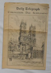
newspaper supplement, Coronation Day Supplement, June 2 1953
... George VI, on 6 February 1952, and was proclaimed queen by her various privy and executive councils shortly afterwards. The ceremony took place at Westminster Abbey. Celebrations took place and a commemorative medal was issued throughout the Commonwealth. Saving an item dedicated to the royal family is typical of the general feeling of respect and admiration felt by the rural communities towards the British Royal Family, especially towards Queen Elizabeth II. newspaper-supplement-Daily-Telegraph coronation royal-family Elizabeth-11 A supplement from the Daily Telegraph, June 2 1953, titled Coronation Day Supplement. ...The Daily Telegraph is a broadsheet newspaper published in London by Telegraph Media Group and distributed across the United Kingdom and internationally. It was founded by Arthur B. Sleigh in 1855 as The Daily Telegraph and Courier. The coronation of Queen Elizabeth II as monarch of the United Kingdom, Canada, Australia, New Zealand, the Union of South Africa, Pakistan, and Ceylon took place on 2 June 1953. Elizabeth ascended the throne at the age of 25, upon the death of her father, King George VI, on 6 February 1952, and was proclaimed queen by her various privy and executive councils shortly afterwards. The ceremony took place at Westminster Abbey. Celebrations took place and a commemorative medal was issued throughout the Commonwealth. Saving an item dedicated to the royal family is typical of the general feeling of respect and admiration felt by the rural communities towards the British Royal Family, especially towards Queen Elizabeth II.A supplement from the Daily Telegraph, June 2 1953, titled Coronation Day Supplement. On the front cover is a b/w picture of Westminster Abbey.newspaper-supplement-daily-telegraph coronation royal-family elizabeth-11 -
 Orbost & District Historical Society
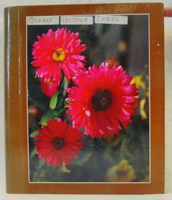
album, Granny Hossack, 1914-1917
... Day 1852. "Granny" Hossack was born in 1821 and died in 1921 within two months of a century. James and Penuel had one daughter, Penuel who married Robert Pullar Cameron at Orbost. They had two sons, James(1858) and George...Day 1852. "Granny" Hossack was born in 1821 and died in 1921 within two months of a century. James and Penuel had one daughter, Penuel who married Robert Pullar Cameron at Orbost. They had two sons, James(1858) and George ...James Hossack and his wife, Penuel, arrived from Scotland to Geelong on Christmas Day 1852. "Granny" Hossack was born in 1821 and died in 1921 within two months of a century. James and Penuel had one daughter, Penuel who married Robert Pullar Cameron at Orbost. They had two sons, James(1858) and George(1860). James Hossack and his wife, Penuel, arrived from Scotland to Geelong on Christmas Day 1852. The Hossacks travelled to Australia on the "Ann Thompson"The Hossack family was a prominent Orbost family with strong ties to the Presbyterian Church in Orbost. This item is a part of the Hossack family history.A brown rectangular shaped photo album On front is a print of three large pink/red dahlia flowers. It has a pasted on label - GRANNY HOSSACKS CARDS. It has plastic sheets inside with a collection of cards sent to Granny Hossack -Christmas, funeral, New Year. On first page is a hand-written history of James Hossack and his wife Penuel.album "granny"-hossack hossack -
 Federation University Historical Collection
Photograph - Photograph - black and white, c1930
... .1) George Edgar Godlip Yung seated on a swing and two children, possibly grandchildren Alice (b1914) and Grace (b1915) Watson. Note bridge in background so perhaps Peterborough? .2) A family outing to the beach on a cold, windy day...On the left of the photo is George Edgar Yung, his brother-in-law and most likely the lady on the right is his sister Clara. They are rugged up for the day. ....1) George Edgar Godlip Yung seated on a swing and two children, possibly grandchildren Alice (b1914) and Grace (b1915) Watson. Note bridge in background so perhaps Peterborough? .2) A family outing to the beach on a cold, windy day. Uncle Ted was Charles Edward Smith, an Anglican minister and the son of George Henry and Emma (b Keys) Smith and a sister of Clara Emma Yung (b Smith). On the left of the photo is George Edgar Yung, his brother-in-law and most likely the lady on the right is his sister Clara. They are rugged up for the day. Note the steel tips on 'Clara's shoes. Two black and white photographs at Warrnambool Beach..1) G E Yung ;( crossed out - Alice and Grace) Watson .2) Uncle Ted and partywarrnambool, warrnambool beach, charles edward smith, clara emma yung, george edgar godlip yung, peterborough -
 Lara RSL Sub Branch
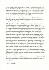
Statement By Eric George Elliott on the Light Horse Brigade charge at Beersheba
... This statement by Eric George Elliott tells how The battle of Beersheba took place on 31 October 1917 as part of the wider British offensive collectively known as the third Battle of Gaza. The final phase of this all day...day after success at Beersheba. ww!, beersheba, statement, photocopy, australian light horse brigade. Rectangular shaped glass covered picture frame with a photocopy of his statement on the charge of Beersheba. Statement By Eric George ...This statement by Eric George Elliott tells how The battle of Beersheba took place on 31 October 1917 as part of the wider British offensive collectively known as the third Battle of Gaza. The final phase of this all day battle was the famous mounted charge of the 4th Light Horse Brigade. Commencing at dusk, members of the brigade stormed through the Turkish defences and seized the strategic town of Beersheba. The capture of Beersheba enabled British Empire forces to break the Ottoman line near Gaza on 7 November and advance into Palestine.Decisive victory at Beersheba fell to one of the last great charges of mounted troops in history. As Australian Light Horse Divisions captured the town and secured crucial water wells, their success also marked the beginning of the end of the war in the Middle East. This end came exactly a year to the day after success at Beersheba.Rectangular shaped glass covered picture frame with a photocopy of his statement on the charge of Beersheba.ww!, beersheba, statement, photocopy, australian light horse brigade. -
 Lara RSL Sub Branch
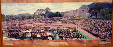
Photograph of Anzac day in the National Capital by Ben Wrigley
... CAMBERRA Australia's National Capital. ...the establishment of the Capital at Camberra will go far towards intensifying the national spirit which is so strong a feature of Australia's nationhood.Senator the Rt Hon George Pearce,Minister for Home and Territories,1926. Photograph of ANZAC DAY in the National Capital by Ben Wrigley Produced by the National Capitol Authority....It marks the anniversary of the first major military action fought by Australian and New Zealand forces during the First World War anzac photographs lara r.s.l. ww1 anzac day in the national capitol CAMBERRA Australia's National Capital. ...the establishment of the Capital at Camberra will go far towards intensifying the national spirit which is so strong a feature of Australia's nationhood.Senator the Rt Hon George Pearce,Minister for Home and Territories,1926. ...Anzac Day is a national day of remembrance in Australia and New Zealand that broadly commemorates all Australians and New Zealanders "who served and died in all wars, conflicts, and peacekeeping operations"Anzac Day, 25 April, is one of Australia’s most important national occasions. It marks the anniversary of the first major military action fought by Australian and New Zealand forces during the First World War Rectangular Framed Photograph,(Glass covered) with a wooden frameCAMBERRA Australia's National Capital. ...the establishment of the Capital at Camberra will go far towards intensifying the national spirit which is so strong a feature of Australia's nationhood.Senator the Rt Hon George Pearce,Minister for Home and Territories,1926. Photograph of ANZAC DAY in the National Capital by Ben Wrigley Produced by the National Capitol Authority.anzac, photographs, lara r.s.l., ww1, anzac day in the national capitol -
 Ballarat Clarendon College
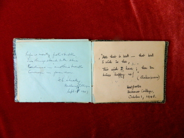
Autograph book
... Staff names include - George Hay, Keith Young, Hewson, Stuckey, Porter, Student surnames include - Price, McClure, Hewitt, Davidson, Dehnert, Dodd, Cameron, Fraser, Gibson, Walker, McDonald, Ronaldson, Gray, Naismith, Fyffe, Oxburn, Dyer, Cumming, Coulson, Gilbert, Gilmour, Chester, Young, Gray-McIntosh Girls names include - Barbara Day, ...Staff names include - George Hay, Keith Young, Hewson, Stuckey, Porter, Student surnames include - Price, McClure, Hewitt, Davidson, Dehnert, Dodd, Cameron, Fraser, Gibson, Walker, McDonald, Ronaldson, Gray, Naismith, Fyffe, Oxburn, Dyer, Cumming, Coulson, Gilbert, Gilmour, Chester, Young, Gray-McIntosh Girls names include - Barbara Day, Handwritten signatures and sayings throughout book Small autograph book with faux snake-skin cover and coloured pages Autograph book ...This book was completed with autographs from fellow students at Ballarat College during Bruce's years at the school (1946 - 1953). Includes some staff signiatures and greetings. Staff names include - George Hay, Keith Young, Hewson, Stuckey, Porter, Student surnames include - Price, McClure, Hewitt, Davidson, Dehnert, Dodd, Cameron, Fraser, Gibson, Walker, McDonald, Ronaldson, Gray, Naismith, Fyffe, Oxburn, Dyer, Cumming, Coulson, Gilbert, Gilmour, Chester, Young, Gray-McIntosh Girls names include - Barbara Day, Small autograph book with faux snake-skin cover and coloured pagesHandwritten signatures and sayings throughout book -
 Bright & District Historical Society operating the Bright Museum
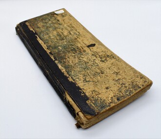
Day Book
... Day book kept by Alexander Walker, Cartage Contractor, father of Council employee Bill Walker, as noted by Jean Telford. On pages 156- 159, Walker records details of an incident between William Oaks and himself when they were in the Boot Shop of Mr George Chatfield and Oaks accused Walker of stealing his fence.Oaks called him a liar, a rogue,a thief and a coward. ...Day book kept by Alexander Walker, Cartage Contractor, father of Council employee Bill Walker, as noted by Jean Telford. On pages 156- 159, Walker records details of an incident between William Oaks and himself when they were in the Boot Shop of Mr George Chatfield and Oaks accused Walker of stealing his fence.Oaks called him a liar, a rogue,a thief and a coward. ...Item donated. Day book kept by Alexander Walker, Cartage Contractor, father of Council employee Bill Walker, as noted by Jean Telford. On pages 156- 159, Walker records details of an incident between William Oaks and himself when they were in the Boot Shop of Mr George Chatfield and Oaks accused Walker of stealing his fence.Oaks called him a liar, a rogue,a thief and a coward. Walker justifies his behaviour with respect to the wood in dispute. Page 185.Very old day book with heavy cardboard covers with most of original green colour removed by daily use. Binding black.Inside front cover: A. Walker / Bright / 26th Augt./ 1897 Numerical additions -see image Front page: Top of page: Myrtleford / inscription crossed out - see image Further down page: Day Book / 5th Oct. '03 /Alexr. Walker / Gavan St / Bright Below above inscription: Alex Walker - Cartage Contractor / Father of late Bill Walker - Council Employee / Bright -
 Federation University Historical Collection
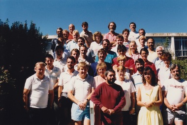
Photograph - Photograph - Colour, Artafact, VIOSH - Occupational Hazard Management Course, Intake 12,1988, 1988
... george card...sandra clarke...kevin currie...marian day...VIOSH accepts people into the Graduate Diploma of Occupational Hazard Management who have no undergraduate degree - on the basis of extensive work experience and knowledge. viosh viosh australia occupatonal health and safety victorian institute of occupational safety and health neil absolon sean bath sharon burnell geoffrey byers kevin campbell george card sandra clarke kevin currie marian day malcolm dorricott jennifer gallagher robert goodbourn neil gude jill gutteridge glenn hughes joseph holecka maria mchugh geoffrey moore carey murphy philip myers andrew nykoluk kathleen peeters jean prosper shaun quinn alan riley michael rose sarah ross patricia seide tony thatcher tony van maanenberg brett wood ballarat college of advanced education Framers details verso lls: "Artafact" Brown and gold framed photograph with title and names of students underneath. ...Victorian Institute of Occupational Safety and Health (VIOSH) Australia is the Asia-Pacific centre for teaching and research in occupational health and safety (OHS) and is known as one of Australia's leaders on the field. VIOSH has a global reputation for its innovative approach within the field of OHS management. VIOSH had its first intake of students in 1979. At that time the Institution was known as the Ballarat College of Advanced Education. In 1990 it became known as Ballarat University College, then in 1994 as University of Ballarat. It was 2014 that it became Federation University. VIOSH Australia students are safety managers, senior advisors and experienced OHS professionals. They come from all over Australia and industry. Students are taught active research and enquiry; rather than textbook learning and a one-size fits all approach. VIOSH accepts people into the Graduate Diploma of Occupational Hazard Management who have no undergraduate degree - on the basis of extensive work experience and knowledge. Brown and gold framed photograph with title and names of students underneath.Framers details verso lls: "Artafact"viosh, viosh australia, occupatonal health and safety, victorian institute of occupational safety and health, neil absolon, sean bath, sharon burnell, geoffrey byers, kevin campbell, george card, sandra clarke, kevin currie, marian day, malcolm dorricott, jennifer gallagher, robert goodbourn, neil gude, jill gutteridge, glenn hughes, joseph holecka, maria mchugh, geoffrey moore, carey murphy, philip myers, andrew nykoluk, kathleen peeters, jean prosper, shaun quinn, alan riley, michael rose, sarah ross, patricia seide, tony thatcher, tony van maanenberg, brett wood, ballarat college of advanced education -
 Federation University Historical Collection
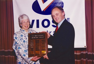
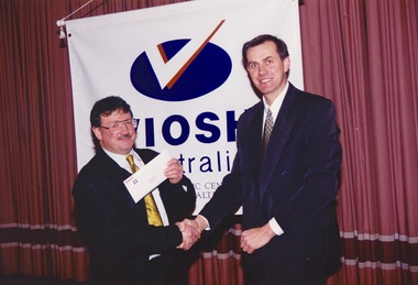
Photograph - Photograph -colour, VIOSH Australia Annual Dinner, July 1999: Presentation of Award to David Knowles
... george cavanagh...paul coghlan...bryan colburn...timothy crouch...iain day...VIOSH accepts people into the Graduate Diploma of Occupational Hazard Management who have no undergraduate degree – on the basis of extensive work experience and knowledge. viosh viosh australia occupational health and safety victorian institute of occupational health and safety occupational hazard management ian benjamin susan capper george cavanagh paul coghlan bryan colburn timothy crouch iain day karina dine david ellis ken fuhrmeister iain gillespie donald gillies linda grannas rhonda hall sue hardy genevieve hawkins paul hennekam danielle mik jo millard vanessa moore ashok nath geoffrey poulton terry ridley jennifer sever brian smith kerry smith krystie spratt ian sterry david taylor sean turner allison warwick judith wenban stuart wright william wasley linda smith john maclean steven baldwin paul brass phil clark dennis cordner save crawcour steven duke david fitzgerald julie fitzgerald gary lennon patrick mcattackney sue pannet stephen pavlich lloyd quarmby noel read tricia smith robert turner barrie wright max brooke memorial prize david knowles dulcie brooke memorial shield Professional coloured photographs. ...Victorian Institute of Occupational Safety and Health (VIOSH) Australia is the Asia-Pacific centre for teaching and research in occupational health and safety (OHS) and is known as one of Australia's leaders in the field. VIOSH has a global reputation for its innovative approach within the field of OHS management. Federation University VIOSH Australia students are safety managers, senior advisors and experienced OHS professionals. They come from all over Australia and industry. Students are taught active research and enquiry; rather than textbook learning and a one-size fits all approach. VIOSH accepts people into the Graduate Diploma of Occupational Hazard Management who have no undergraduate degree – on the basis of extensive work experience and knowledge.Professional coloured photographs. Presenter and recipient standing in front of VIOSH banner.viosh, viosh australia, occupational health and safety, victorian institute of occupational health and safety, occupational hazard management, ian benjamin, susan capper, george cavanagh, paul coghlan, bryan colburn, timothy crouch, iain day, karina dine, david ellis, ken fuhrmeister, iain gillespie, donald gillies, linda grannas, rhonda hall, sue hardy, genevieve hawkins, paul hennekam, danielle mik, jo millard, vanessa moore, ashok nath, geoffrey poulton, terry ridley, jennifer sever, brian smith, kerry smith, krystie spratt, ian sterry, david taylor, sean turner, allison warwick, judith wenban, stuart wright, william wasley, linda smith, john maclean, steven baldwin, paul brass, phil clark, dennis cordner, save crawcour, steven duke, david fitzgerald, julie fitzgerald, gary lennon, patrick mcattackney, sue pannet, stephen pavlich, lloyd quarmby, noel read, tricia smith, robert turner, barrie wright, max brooke memorial prize, david knowles, dulcie brooke, memorial shield -
 Federation University Historical Collection
Photograph - Photograph -colour, VIOSH Australia Annual Dinner, July 1998: Presentation of Awards
... george cavanagh...paul coghlan...bryan colburn...timothy crouch...iain day...People present would possibly be those who were in the Intake for the course in 1996. viosh viosh australia occupational health and safety victorian institute of occupational health and safety occupational hazard management ian benjamin susan capper george cavanagh paul coghlan bryan colburn timothy crouch iain day karina dine david ellis ken fuhrmeister iain gillespie donald gillies linda grannas rhonda hall sue hardy genevieve hawkins paul hennekam danielle mik jo millard vanessa moore ashok nath geoffrey poulton terry ridley jennifer sever brian smith kerry smith krystie spratt ian sterry andrew stevens david taylor sean turner allison warwick judith wenban stuart wright william wasley linda smith dulcie brooke Six coloured photographs showing groups at the VIOSH Annual Dinner in 1998. ...Victorian Institute of Occupational Safety and Health (VIOSH) Australia is the Asia-Pacific centre for teaching and research in occupational health and safety (OHS) and is known as one of Australia's leaders in the field. VIOSH has a global reputation for its innovative approach within the field of OHS management. Federation University VIOSH Australia students are safety managers, senior advisors and experienced OHS professionals. They come from all over Australia and industry. Students are taught active research and enquiry; rather than textbook learning and a one-size fits all approach. VIOSH accepts people into the Graduate Diploma of Occupational Hazard Management who have no undergraduate degree – on the basis of extensive work experience and knowledge. People present would possibly be those who were in the Intake for the course in 1996. Six coloured photographs showing groups at the VIOSH Annual Dinner in 1998.viosh, viosh australia, occupational health and safety, victorian institute of occupational health and safety, occupational hazard management, ian benjamin, susan capper, george cavanagh, paul coghlan, bryan colburn, timothy crouch, iain day, karina dine, david ellis, ken fuhrmeister, iain gillespie, donald gillies, linda grannas, rhonda hall, sue hardy, genevieve hawkins, paul hennekam, danielle mik, jo millard, vanessa moore, ashok nath, geoffrey poulton, terry ridley, jennifer sever, brian smith, kerry smith, krystie spratt, ian sterry, andrew stevens, david taylor, sean turner, allison warwick, judith wenban, stuart wright, william wasley, linda smith, dulcie brooke -
 Federation University Historical Collection
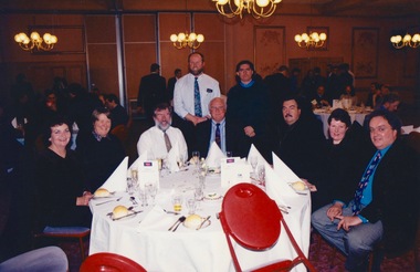
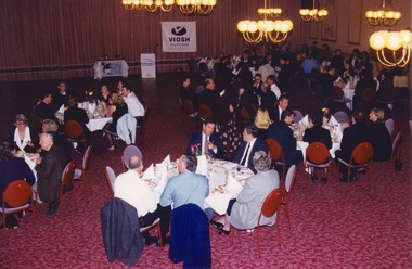
Photograph - Photograph -colour, VIOSH Australia Annual Dinner, July 1999: Presentation of Awards
... george cavanagh...paul coghlan...bryan colburn...timothy crouch...iain day...VIOSH accepts people into the Graduate Diploma of Occupational Hazard Management who have no undergraduate degree - on the basis of extensive work experience and knowledge. viosh viosh australia occupational health and safety victorian institute of occupational health and safety occupational hazard management ian benjamin susan capper george cavanagh paul coghlan bryan colburn timothy crouch iain day karina dine david ellis ken fuhrmeister iain gillespie donald gillies linda grannas rhonda hall sue hardy genevieve hawkins paul hennekam danielle mik jo millard vanessa moore ashok nath geoffrey poulton terry ridley jennifer sever brian smith kerry smith krystie spratt ian sterry david taylor sean turner allison warwick judith wenban stuart wright william wasley linda smith john maclean steven baldwin paul brass phil clark dennis cordner save crawcour steven duke david fitzgerald julie fitzgerald gary lennon patrick mcattackney sue pannet stephen pavlich lloyd quarmby noel read tricia smith robert turner barrie wright Professional coloured photographs showing guests at the dinner - eighteen photos VIOSH Australia Annual Dinner, July 1999: Presentation of Awards Photograph Photograph -colour ...Victorian Institute of Occupational Safety and Health (VIOSH) Australia is the Asia-Pacific centre for teaching and research in occupational health and safety (OHS) and is known as one of Australia's leaders on the field. VIOSH has a global reputation for its innovative approach within the field of OHS management. VIOSH had its first intake of students in 1979. At that time the Institution was known as the Ballarat College of Advanced Education. In 1990 it became known as Ballarat University College, then in 1994 as University of Ballarat. It was 2014 that it became Federation University. VIOSH Australia students are safety managers, senior advisors and experienced OHS professionals. They come from all over Australia and industry. Students are taught active research and enquiry; rather than textbook learning and a one-size fits all approach. VIOSH accepts people into the Graduate Diploma of Occupational Hazard Management who have no undergraduate degree - on the basis of extensive work experience and knowledge. Professional coloured photographs showing guests at the dinner - eighteen photosviosh, viosh australia, occupational health and safety, victorian institute of occupational health and safety, occupational hazard management, ian benjamin, susan capper, george cavanagh, paul coghlan, bryan colburn, timothy crouch, iain day, karina dine, david ellis, ken fuhrmeister, iain gillespie, donald gillies, linda grannas, rhonda hall, sue hardy, genevieve hawkins, paul hennekam, danielle mik, jo millard, vanessa moore, ashok nath, geoffrey poulton, terry ridley, jennifer sever, brian smith, kerry smith, krystie spratt, ian sterry, david taylor, sean turner, allison warwick, judith wenban, stuart wright, william wasley, linda smith, john maclean, steven baldwin, paul brass, phil clark, dennis cordner, save crawcour, steven duke, david fitzgerald, julie fitzgerald, gary lennon, patrick mcattackney, sue pannet, stephen pavlich, lloyd quarmby, noel read, tricia smith, robert turner, barrie wright -
 Federation University Historical Collection
Photograph - Photograph -colour, VIOSH Australia Annual Dinner, July 1998: Presentation of Award to Donna Korke
... george cavanagh...paul coghlan...bryan colburn...timothy crouch...iain day...VIOSH accepts people into the Graduate Diploma of Occupational Hazard Management who have no undergraduate degree – on the basis of extensive work experience and knowledge. viosh viosh australia occupational health and safety victorian institute of occupational health and safety occupational hazard management ian benjamin susan capper george cavanagh paul coghlan bryan colburn timothy crouch iain day karina dine david ellis ken fuhrmeister iain gillespie donald gillies linda grannas rhonda hall sue hardy genevieve hawkins paul hennekam danielle mik jo millard vanessa moore ashok nath geoffrey poulton terry ridley jennifer sever brian smith kerry smith krystie spratt ian sterry andrew stevens david taylor sean turner allison warwick judith wenban stuart wright william wasley linda smith national safety council of australia trophy donna korke frank anderson Professional coloured photographs. ...Victorian Institute of Occupational Safety and Health (VIOSH) Australia is the Asia-Pacific centre for teaching and research in occupational health and safety (OHS) and is known as one of Australia's leaders in the field. VIOSH has a global reputation for its innovative approach within the field of OHS management. Federation University VIOSH Australia students are safety managers, senior advisors and experienced OHS professionals. They come from all over Australia and industry. Students are taught active research and enquiry; rather than textbook learning and a one-size fits all approach. VIOSH accepts people into the Graduate Diploma of Occupational Hazard Management who have no undergraduate degree – on the basis of extensive work experience and knowledge.Professional coloured photographs. Presenter and recipient standing in front of VIOSH banner.viosh, viosh australia, occupational health and safety, victorian institute of occupational health and safety, occupational hazard management, ian benjamin, susan capper, george cavanagh, paul coghlan, bryan colburn, timothy crouch, iain day, karina dine, david ellis, ken fuhrmeister, iain gillespie, donald gillies, linda grannas, rhonda hall, sue hardy, genevieve hawkins, paul hennekam, danielle mik, jo millard, vanessa moore, ashok nath, geoffrey poulton, terry ridley, jennifer sever, brian smith, kerry smith, krystie spratt, ian sterry, andrew stevens, david taylor, sean turner, allison warwick, judith wenban, stuart wright, william wasley, linda smith, national safety council of australia, trophy, donna korke, frank anderson -
Federation University Historical Collection
Photograph - Photograph -colour, VIOSH Australia Annual Dinner, July 1999: Presentation of Award to John MacLean
... george cavanagh...paul coghlan...bryan colburn...timothy crouch...iain day...VIOSH accepts people into the Graduate Diploma of Occupational Hazard Management who have no undergraduate degree – on the basis of extensive work experience and knowledge. viosh viosh australia occupational health and safety victorian institute of occupational health and safety occupational hazard management ian benjamin susan capper george cavanagh paul coghlan bryan colburn timothy crouch iain day karina dine david ellis ken fuhrmeister iain gillespie donald gillies linda grannas rhonda hall sue hardy genevieve hawkins paul hennekam danielle mik jo millard vanessa moore ashok nath geoffrey poulton terry ridley jennifer sever brian smith kerry smith krystie spratt ian sterry david taylor sean turner allison warwick judith wenban stuart wright william wasley linda smith oliver footwear share solution award john maclean steve cowley steven baldwin paul brass phil clark dennis cordner save crawcour steven duke david fitzgerald julie fitzgerald gary lennon patrick mcattackney sue pannet stephen pavlich lloyd quarmby noel read tricia smith robert turner barrie wright Professional coloured photographs. ...Victorian Institute of Occupational Safety and Health (VIOSH) Australia is the Asia-Pacific centre for teaching and research in occupational health and safety (OHS) and is known as one of Australia's leaders in the field. VIOSH has a global reputation for its innovative approach within the field of OHS management. Federation University VIOSH Australia students are safety managers, senior advisors and experienced OHS professionals. They come from all over Australia and industry. Students are taught active research and enquiry; rather than textbook learning and a one-size fits all approach. VIOSH accepts people into the Graduate Diploma of Occupational Hazard Management who have no undergraduate degree – on the basis of extensive work experience and knowledge.Professional coloured photographs. Presenter and recipient standing in front of VIOSH banner.viosh, viosh australia, occupational health and safety, victorian institute of occupational health and safety, occupational hazard management, ian benjamin, susan capper, george cavanagh, paul coghlan, bryan colburn, timothy crouch, iain day, karina dine, david ellis, ken fuhrmeister, iain gillespie, donald gillies, linda grannas, rhonda hall, sue hardy, genevieve hawkins, paul hennekam, danielle mik, jo millard, vanessa moore, ashok nath, geoffrey poulton, terry ridley, jennifer sever, brian smith, kerry smith, krystie spratt, ian sterry, david taylor, sean turner, allison warwick, judith wenban, stuart wright, william wasley, linda smith, oliver footwear share solution award, john maclean, steve cowley, steven baldwin, paul brass, phil clark, dennis cordner, save crawcour, steven duke, david fitzgerald, julie fitzgerald, gary lennon, patrick mcattackney, sue pannet, stephen pavlich, lloyd quarmby, noel read, tricia smith, robert turner, barrie wright -
Federation University Historical Collection
Document - Details of applicants for OHM course, VIOSH: Ballarat College of Advanced Education Occupational Hazard Management Applicants, Intake 12A, 1988
... george card...sandra clarke...kevin currie...marian day...Intake 12A merged with 12B due to this. viosh victorian institute of occupational safety and health occupational hazard management ballarat college of advanced education ballarat university college university of ballarat federation university robert absolon sean bath mark bright geoffrey byers kevin campbell george card sandra clarke kevin currie marian day malcolm dorricott jennifer gallagher robert goodbourne neil gude jill gutteridge joseph holecka glenn hughes ray jackson eleven johns maria mchugh geoffrey moore carey murphy philip myers andrew nykoluk kathleen peeters jean prosper alan riley michael rose sarah ross patricia seide antony thatcher william wood Name, town, state, occupation, company, beside each photograph Eight pages with small portrait photographs of applicants - 4 per page. ...Victorian Institute of Occupational Safety and Health (VIOSH) Australia is the Asia-Pacific centre for teaching and research in occupational health and safety (OHS) and is known as one of Australia's leaders on the field. VIOSH has a global reputation for its innovative approach within the field of OHS management. VIOSH had its first intake of students in 1979. At that time the Institution was known as the Ballarat College of Advanced Education. In 1990 it became known as Ballarat University College, then in 1994 as University of Ballarat. It was 2014 that it became Federation University. VIOSH Australia students are safety managers, senior advisors and experienced OHS professionals. They come from all over Australia and industry. Students are taught active research and enquiry; rather than textbook learning and a one-size fits all approach. VIOSH accepts people into the Graduate Diploma of Occupational Hazard Management who have no undergraduate degree - on the basis of extensive work experience and knowledge. Each application required details of their work occupation and the company work department they were employed in. Not all of those who applied began the OHM course. Some withdrew - no indication of reason. Intake 12A merged with 12B due to this.Eight pages with small portrait photographs of applicants - 4 per page. Photographs are various sizes.Name, town, state, occupation, company, beside each photographviosh, victorian institute of occupational safety and health, occupational hazard management, ballarat college of advanced education, ballarat university college, university of ballarat, federation university, robert absolon, sean bath, mark bright, geoffrey byers, kevin campbell, george card, sandra clarke, kevin currie, marian day, malcolm dorricott, jennifer gallagher, robert goodbourne, neil gude, jill gutteridge, joseph holecka, glenn hughes, ray jackson, eleven johns, maria mchugh, geoffrey moore, carey murphy, philip myers, andrew nykoluk, kathleen peeters, jean prosper, alan riley, michael rose, sarah ross, patricia seide, antony thatcher, william wood -
 Federation University Historical Collection
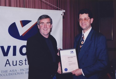
Photograph - Photograph -colour, VIOSH Australia Annual Dinner, July 1998: Presentation of Award to Andrew Stevens
... george cavanagh...paul coghlan...bryan colburn...timothy crouch...iain day...VIOSH accepts people into the Graduate Diploma of Occupational Hazard Management who have no undergraduate degree – on the basis of extensive work experience and knowledge. viosh viosh australia occupational health and safety victorian institute of occupational health and safety occupational hazard management ian benjamin susan capper george cavanagh paul coghlan bryan colburn timothy crouch iain day karina dine david ellis ken fuhrmeister iain gillespie donald gillies linda grannas rhonda hall sue hardy genevieve hawkins paul hennekam danielle mik jo millard vanessa moore ashok nath geoffrey poulton terry ridley jennifer sever brian smith kerry smith krystie spratt ian sterry david taylor sean turner allison warwick judith wenban stuart wright william wasley linda smith rae epthorp human factors prize steve cowley andrew stevens Professional coloured photographs. ...Victorian Institute of Occupational Safety and Health (VIOSH) Australia is the Asia-Pacific centre for teaching and research in occupational health and safety (OHS) and is known as one of Australia's leaders in the field. VIOSH has a global reputation for its innovative approach within the field of OHS management. Federation University VIOSH Australia students are safety managers, senior advisors and experienced OHS professionals. They come from all over Australia and industry. Students are taught active research and enquiry; rather than textbook learning and a one-size fits all approach. VIOSH accepts people into the Graduate Diploma of Occupational Hazard Management who have no undergraduate degree – on the basis of extensive work experience and knowledge.Professional coloured photographs. Presenter and recipient standing in front of VIOSH banner.viosh, viosh australia, occupational health and safety, victorian institute of occupational health and safety, occupational hazard management, ian benjamin, susan capper, george cavanagh, paul coghlan, bryan colburn, timothy crouch, iain day, karina dine, david ellis, ken fuhrmeister, iain gillespie, donald gillies, linda grannas, rhonda hall, sue hardy, genevieve hawkins, paul hennekam, danielle mik, jo millard, vanessa moore, ashok nath, geoffrey poulton, terry ridley, jennifer sever, brian smith, kerry smith, krystie spratt, ian sterry, david taylor, sean turner, allison warwick, judith wenban, stuart wright, william wasley, linda smith, rae epthorp human factors prize, steve cowley, andrew stevens -
 Federation University Historical Collection
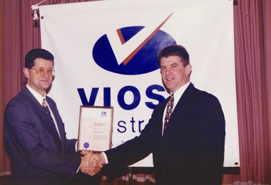
Photograph - Photograph -colour, VIOSH Australia Annual Dinner, July 1998: Presentation of Award to Jennifer Marsh
... george cavanagh...paul coghlan...bryan colburn...timothy crouch...iain day...VIOSH accepts people into the Graduate Diploma of Occupational Hazard Management who have no undergraduate degree – on the basis of extensive work experience and knowledge. viosh viosh australia occupational health and safety victorian institute of occupational health and safety occupational hazard management ian benjamin susan capper george cavanagh paul coghlan bryan colburn timothy crouch iain day karina dine david ellis ken fuhrmeister iain gillespie donald gillies linda grannas rhonda hall sue hardy genevieve hawkins paul hennekam danielle mik jo millard vanessa moore ashok nath geoffrey poulton terry ridley jennifer sever brian smith kerry smith krystie spratt ian sterry david taylor sean turner allison warwick judith wenban stuart wright william wasley linda smith safety institute of australia dissertation prize jennifer marsh chris knight Professional coloured photographs. ...Victorian Institute of Occupational Safety and Health (VIOSH) Australia is the Asia-Pacific centre for teaching and research in occupational health and safety (OHS) and is known as one of Australia's leaders in the field. VIOSH has a global reputation for its innovative approach within the field of OHS management. Federation University VIOSH Australia students are safety managers, senior advisors and experienced OHS professionals. They come from all over Australia and industry. Students are taught active research and enquiry; rather than textbook learning and a one-size fits all approach. VIOSH accepts people into the Graduate Diploma of Occupational Hazard Management who have no undergraduate degree – on the basis of extensive work experience and knowledge.Professional coloured photographs. Presenter and recipient standing in front of VIOSH banner.viosh, viosh australia, occupational health and safety, victorian institute of occupational health and safety, occupational hazard management, ian benjamin, susan capper, george cavanagh, paul coghlan, bryan colburn, timothy crouch, iain day, karina dine, david ellis, ken fuhrmeister, iain gillespie, donald gillies, linda grannas, rhonda hall, sue hardy, genevieve hawkins, paul hennekam, danielle mik, jo millard, vanessa moore, ashok nath, geoffrey poulton, terry ridley, jennifer sever, brian smith, kerry smith, krystie spratt, ian sterry, david taylor, sean turner, allison warwick, judith wenban, stuart wright, william wasley, linda smith, safety institute of australia dissertation prize, jennifer marsh, chris knight -
 Federation University Historical Collection
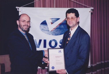
Photograph - Photograph -colour, VIOSH Australia Annual Dinner, July 1999: Presentation of Award to John MacLean
... george cavanagh...paul coghlan...bryan colburn...timothy crouch...iain day...VIOSH accepts people into the Graduate Diploma of Occupational Hazard Management who have no undergraduate degree – on the basis of extensive work experience and knowledge. viosh viosh australia occupational health and safety victorian institute of occupational health and safety occupational hazard management ian benjamin susan capper george cavanagh paul coghlan bryan colburn timothy crouch iain day karina dine david ellis ken fuhrmeister iain gillespie donald gillies linda grannas rhonda hall sue hardy genevieve hawkins paul hennekam danielle mik jo millard vanessa moore ashok nath geoffrey poulton terry ridley jennifer sever brian smith kerry smith krystie spratt ian sterry david taylor sean turner allison warwick judith wenban stuart wright william wasley linda smith oliver footwear share solution award john maclean steve cowley steven baldwin paul brass phil clark dennis cordner save crawcour steven duke david fitzgerald julie fitzgerald gary lennon patrick mcattackney sue pannet stephen pavlich lloyd quarmby noel read tricia smith robert turner barrie wright Professional coloured photographs. ...Victorian Institute of Occupational Safety and Health (VIOSH) Australia is the Asia-Pacific centre for teaching and research in occupational health and safety (OHS) and is known as one of Australia's leaders in the field. VIOSH has a global reputation for its innovative approach within the field of OHS management. Federation University VIOSH Australia students are safety managers, senior advisors and experienced OHS professionals. They come from all over Australia and industry. Students are taught active research and enquiry; rather than textbook learning and a one-size fits all approach. VIOSH accepts people into the Graduate Diploma of Occupational Hazard Management who have no undergraduate degree – on the basis of extensive work experience and knowledge.Professional coloured photographs. Presenter and recipient standing in front of VIOSH banner.viosh, viosh australia, occupational health and safety, victorian institute of occupational health and safety, occupational hazard management, ian benjamin, susan capper, george cavanagh, paul coghlan, bryan colburn, timothy crouch, iain day, karina dine, david ellis, ken fuhrmeister, iain gillespie, donald gillies, linda grannas, rhonda hall, sue hardy, genevieve hawkins, paul hennekam, danielle mik, jo millard, vanessa moore, ashok nath, geoffrey poulton, terry ridley, jennifer sever, brian smith, kerry smith, krystie spratt, ian sterry, david taylor, sean turner, allison warwick, judith wenban, stuart wright, william wasley, linda smith, oliver footwear share solution award, john maclean, steve cowley, steven baldwin, paul brass, phil clark, dennis cordner, save crawcour, steven duke, david fitzgerald, julie fitzgerald, gary lennon, patrick mcattackney, sue pannet, stephen pavlich, lloyd quarmby, noel read, tricia smith, robert turner, barrie wright -
 Federation University Historical Collection
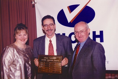
Photograph - Photograph -colour, VIOSH Australia Annual Dinner, July 1999: Presentation of Award to Linda Roberts and Steve Pavlich
... george cavanagh...paul coghlan...bryan colburn...timothy crouch...iain day...VIOSH accepts people into the Graduate Diploma of Occupational Hazard Management who have no undergraduate degree – on the basis of extensive work experience and knowledge. viosh viosh australia occupational health and safety victorian institute of occupational health and safety occupational hazard management ian benjamin susan capper george cavanagh paul coghlan bryan colburn timothy crouch iain day karina dine david ellis ken fuhrmeister iain gillespie donald gillies linda grannas rhonda hall sue hardy genevieve hawkins paul hennekam danielle mik jo millard vanessa moore ashok nath geoffrey poulton terry ridley jennifer sever brian smith kerry smith krystie spratt ian sterry david taylor sean turner allison warwick judith wenban stuart wright william wasley linda smith john maclean steven baldwin paul brass phil clark dennis cordner save crawcour steven duke david fitzgerald julie fitzgerald gary lennon patrick mcattackney sue pannet stephen pavlich lloyd quarmby noel read tricia smith robert turner barrie wright oliver footwear share solution award andrew oliver linda roberts steve pavlich Professional coloured photographs. ...Victorian Institute of Occupational Safety and Health (VIOSH) Australia is the Asia-Pacific centre for teaching and research in occupational health and safety (OHS) and is known as one of Australia's leaders in the field. VIOSH has a global reputation for its innovative approach within the field of OHS management. Federation University VIOSH Australia students are safety managers, senior advisors and experienced OHS professionals. They come from all over Australia and industry. Students are taught active research and enquiry; rather than textbook learning and a one-size fits all approach. VIOSH accepts people into the Graduate Diploma of Occupational Hazard Management who have no undergraduate degree – on the basis of extensive work experience and knowledge.Professional coloured photographs. Presenter and recipient standing in front of VIOSH banner.viosh, viosh australia, occupational health and safety, victorian institute of occupational health and safety, occupational hazard management, ian benjamin, susan capper, george cavanagh, paul coghlan, bryan colburn, timothy crouch, iain day, karina dine, david ellis, ken fuhrmeister, iain gillespie, donald gillies, linda grannas, rhonda hall, sue hardy, genevieve hawkins, paul hennekam, danielle mik, jo millard, vanessa moore, ashok nath, geoffrey poulton, terry ridley, jennifer sever, brian smith, kerry smith, krystie spratt, ian sterry, david taylor, sean turner, allison warwick, judith wenban, stuart wright, william wasley, linda smith, john maclean, steven baldwin, paul brass, phil clark, dennis cordner, save crawcour, steven duke, david fitzgerald, julie fitzgerald, gary lennon, patrick mcattackney, sue pannet, stephen pavlich, lloyd quarmby, noel read, tricia smith, robert turner, barrie wright, oliver footwear share solution award, andrew oliver, linda roberts, steve pavlich -
 Federation University Historical Collection
Photograph - Photograph -colour, VIOSH Australia Annual Dinner, July 1999: Presentation of Award to Trevor Bailey
... george cavanagh...paul coghlan...bryan colburn...timothy crouch...iain day...VIOSH accepts people into the Graduate Diploma of Occupational Hazard Management who have no undergraduate degree – on the basis of extensive work experience and knowledge. viosh viosh australia occupational health and safety victorian institute of occupational health and safety occupational hazard management ian benjamin susan capper george cavanagh paul coghlan bryan colburn timothy crouch iain day karina dine david ellis ken fuhrmeister iain gillespie donald gillies linda grannas rhonda hall sue hardy genevieve hawkins paul hennekam danielle mik jo millard vanessa moore ashok nath geoffrey poulton terry ridley jennifer sever brian smith kerry smith krystie spratt ian sterry david taylor sean turner allison warwick judith wenban stuart wright william wasley linda smith john maclean steven baldwin paul brass phil clark dennis cordner save crawcour steven duke david fitzgerald julie fitzgerald gary lennon patrick mcattackney sue pannet stephen pavlich lloyd quarmby noel read tricia smith robert turner barrie wright the proctor safety travel bursary (master of applied science ohs) trevor bailey darryl gathard Professional coloured photographs. ...Victorian Institute of Occupational Safety and Health (VIOSH) Australia is the Asia-Pacific centre for teaching and research in occupational health and safety (OHS) and is known as one of Australia's leaders in the field. VIOSH has a global reputation for its innovative approach within the field of OHS management. Federation University VIOSH Australia students are safety managers, senior advisors and experienced OHS professionals. They come from all over Australia and industry. Students are taught active research and enquiry; rather than textbook learning and a one-size fits all approach. VIOSH accepts people into the Graduate Diploma of Occupational Hazard Management who have no undergraduate degree – on the basis of extensive work experience and knowledge.Professional coloured photographs. Presenter and recipient standing in front of VIOSH banner.viosh, viosh australia, occupational health and safety, victorian institute of occupational health and safety, occupational hazard management, ian benjamin, susan capper, george cavanagh, paul coghlan, bryan colburn, timothy crouch, iain day, karina dine, david ellis, ken fuhrmeister, iain gillespie, donald gillies, linda grannas, rhonda hall, sue hardy, genevieve hawkins, paul hennekam, danielle mik, jo millard, vanessa moore, ashok nath, geoffrey poulton, terry ridley, jennifer sever, brian smith, kerry smith, krystie spratt, ian sterry, david taylor, sean turner, allison warwick, judith wenban, stuart wright, william wasley, linda smith, john maclean, steven baldwin, paul brass, phil clark, dennis cordner, save crawcour, steven duke, david fitzgerald, julie fitzgerald, gary lennon, patrick mcattackney, sue pannet, stephen pavlich, lloyd quarmby, noel read, tricia smith, robert turner, barrie wright, the proctor safety travel bursary (master of applied science ohs), trevor bailey, darryl gathard -
 Federation University Historical Collection
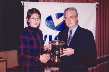
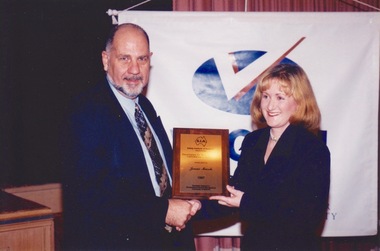
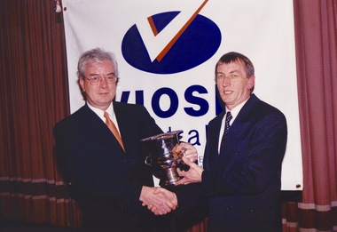
Photograph - Photograph -colour, VIOSH Australia Annual Dinner, July 1999: Presentation of Perpetual Trophy to Richard Benwell
... george cavanagh...paul coghlan...bryan colburn...timothy crouch...iain day...VIOSH accepts people into the Graduate Diploma of Occupational Hazard Management who have no undergraduate degree – on the basis of extensive work experience and knowledge. viosh viosh australia occupational health and safety victorian institute of occupational health and safety occupational hazard management ian benjamin susan capper george cavanagh paul coghlan bryan colburn timothy crouch iain day karina dine david ellis ken fuhrmeister iain gillespie donald gillies linda grannas rhonda hall sue hardy genevieve hawkins paul hennekam danielle mik jo millard vanessa moore ashok nath geoffrey poulton terry ridley jennifer sever brian smith kerry smith krystie spratt ian sterry david taylor sean turner allison warwick judith wenban stuart wright william wasley linda smith john maclean steven baldwin paul brass phil clark dennis cordner save crawcour steven duke david fitzgerald julie fitzgerald gary lennon patrick mcattackney sue pannet stephen pavlich lloyd quarmby noel read tricia smith robert turner barrie wright nsca perpetual trophy for the best academic performance richard benwell frank anderson Professional coloured photographs. ...Victorian Institute of Occupational Safety and Health (VIOSH) Australia is the Asia-Pacific centre for teaching and research in occupational health and safety (OHS) and is known as one of Australia's leaders in the field. VIOSH has a global reputation for its innovative approach within the field of OHS management. Federation University VIOSH Australia students are safety managers, senior advisors and experienced OHS professionals. They come from all over Australia and industry. Students are taught active research and enquiry; rather than textbook learning and a one-size fits all approach. VIOSH accepts people into the Graduate Diploma of Occupational Hazard Management who have no undergraduate degree – on the basis of extensive work experience and knowledge.Professional coloured photographs. Presenter and recipient standing in front of VIOSH banner.viosh, viosh australia, occupational health and safety, victorian institute of occupational health and safety, occupational hazard management, ian benjamin, susan capper, george cavanagh, paul coghlan, bryan colburn, timothy crouch, iain day, karina dine, david ellis, ken fuhrmeister, iain gillespie, donald gillies, linda grannas, rhonda hall, sue hardy, genevieve hawkins, paul hennekam, danielle mik, jo millard, vanessa moore, ashok nath, geoffrey poulton, terry ridley, jennifer sever, brian smith, kerry smith, krystie spratt, ian sterry, david taylor, sean turner, allison warwick, judith wenban, stuart wright, william wasley, linda smith, john maclean, steven baldwin, paul brass, phil clark, dennis cordner, save crawcour, steven duke, david fitzgerald, julie fitzgerald, gary lennon, patrick mcattackney, sue pannet, stephen pavlich, lloyd quarmby, noel read, tricia smith, robert turner, barrie wright, nsca perpetual trophy for the best academic performance, richard benwell, frank anderson -
 Federation University Historical Collection
Photograph - Photograph -colour, VIOSH Australia Annual Dinner, July 1999: Presentation of Award to Matthew Piscioneri
... george cavanagh...paul coghlan...bryan colburn...timothy crouch...iain day...VIOSH accepts people into the Graduate Diploma of Occupational Hazard Management who have no undergraduate degree – on the basis of extensive work experience and knowledge. viosh viosh australia occupational health and safety victorian institute of occupational health and safety occupational hazard management ian benjamin susan capper george cavanagh paul coghlan bryan colburn timothy crouch iain day karina dine david ellis ken fuhrmeister iain gillespie donald gillies linda grannas rhonda hall sue hardy genevieve hawkins paul hennekam danielle mik jo millard vanessa moore ashok nath geoffrey poulton terry ridley jennifer sever brian smith kerry smith krystie spratt ian sterry david taylor sean turner allison warwick judith wenban stuart wright william wasley linda smith john maclean steven baldwin paul brass phil clark dennis cordner save crawcour steven duke david fitzgerald julie fitzgerald gary lennon patrick mcattackney sue pannet stephen pavlich lloyd quarmby noel read tricia smith robert turner barrie wright rae epthorp human factors prize matthew piscioneri steve cowley Professional coloured photographs. ...Victorian Institute of Occupational Safety and Health (VIOSH) Australia is the Asia-Pacific centre for teaching and research in occupational health and safety (OHS) and is known as one of Australia's leaders in the field. VIOSH has a global reputation for its innovative approach within the field of OHS management. Federation University VIOSH Australia students are safety managers, senior advisors and experienced OHS professionals. They come from all over Australia and industry. Students are taught active research and enquiry; rather than textbook learning and a one-size fits all approach. VIOSH accepts people into the Graduate Diploma of Occupational Hazard Management who have no undergraduate degree – on the basis of extensive work experience and knowledge.Professional coloured photographs. Presenter and recipient standing in front of VIOSH banner.viosh, viosh australia, occupational health and safety, victorian institute of occupational health and safety, occupational hazard management, ian benjamin, susan capper, george cavanagh, paul coghlan, bryan colburn, timothy crouch, iain day, karina dine, david ellis, ken fuhrmeister, iain gillespie, donald gillies, linda grannas, rhonda hall, sue hardy, genevieve hawkins, paul hennekam, danielle mik, jo millard, vanessa moore, ashok nath, geoffrey poulton, terry ridley, jennifer sever, brian smith, kerry smith, krystie spratt, ian sterry, david taylor, sean turner, allison warwick, judith wenban, stuart wright, william wasley, linda smith, john maclean, steven baldwin, paul brass, phil clark, dennis cordner, save crawcour, steven duke, david fitzgerald, julie fitzgerald, gary lennon, patrick mcattackney, sue pannet, stephen pavlich, lloyd quarmby, noel read, tricia smith, robert turner, barrie wright, rae epthorp human factors prize, matthew piscioneri, steve cowley