Showing 158 items matching "goulburn river"
-
 Orbost & District Historical Society
black and white photograph, 1930 - 1940
This photograph shows three generations of the Russell family in Orbost. On the left is John Russell with his son Bill Russell and his wife Ede and their son Ian. John Russell Senior was a blacksmith, wheelwright, farmer and chairman of the Orbost Butter Factory, makers of Sunny South Butter (today part of Murray Goulburn Co Ltd). Bill was born at Orbost in 1893, the youngest son of John and Elizabeth Maud (nee Clarke). Upon his father’s retirement he took over the homestead part of the holding, 1,000 acres of river flats and hill land. He was involved in dairying and was also a successful beef cattle breeder and maize grower. He was elected to the Orbost Shire Council in 1929 and shortly afterwards was President for 18 months (from May 1930 to August 1931). He served a further term as President in 1934-35. He represented the South riding. He was chairman of the Bean Board and a well-known horse and show judge and a member of the Royal Agricultural Society. He was an elocutionist of some note and a member of the committee of management of the Orbost Hospital. He was also a prominent member and Past Master of the Masonic Lodge and a Justice of the Peace. He served as president of the Orbost Golf Club and assisted with the preparation and layout of the present Orbost Golf course. This item is associated with the Russell family, early settlers in the Orbost district.A black / white photograph of a family. A lady is in the middle with a man on each side and a young boy in front. They are standing outside a house in the garden.on back - "3 generations, Johnny Russell, Ede & Bill Russell & Ian Russell"russell-family-orbost -
 Marysville & District Historical Society
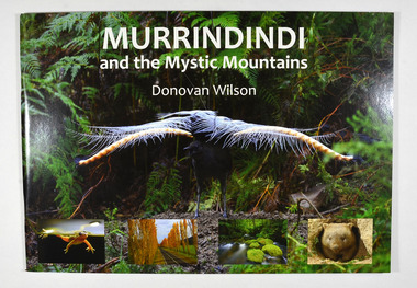
Book, Donovan Wilson, Murrindindi and the Mystic Mountains, Post 2009
A book of photographs of natural attractions, flora and fauna taken in and around the Murrindindi Shire.Paperback. Front cover has a large photograph of a lyrebird in full song. Along the lower edge of the front cover are four photographs; a Spotted March frog, the Gould Memorial Drive, a river and a wombat. Back cover has a photograph of the Cathedral Range at dawn.non-fictionA book of photographs of natural attractions, flora and fauna taken in and around the Murrindindi Shire.murrindindi, victoria, landmarks, flora, fauna, waterfalls, rivers, nature, natural attractions -
 Marysville & District Historical Society
Article (item) - Book extract, Gerald W. Noble, Extract from "The Red Gate"-a history of Alexandra, 1969
An extract from "The Red Gate" regarding the Kulin clan.An extract from "The Red Gate" regarding the Kulin clan.gerald w noble, the red gate, alexandra, kulin tribe, yarra river, ovens river, yauung-illam-baluk, mansfield, john cotton, port phillip, goulburn, lands commissioner lesouef, mining boom, ut creek, donald mckenzie, mohican station, acheron station -
Marysville & District Historical Society
Article (item) - Newspaper article, The Alexandra and Eildon Standard, Indigenous history in the shire after colonisation, 08-03-2017
A newspaper article regarding indigenous history in the Murrindindi Shire after colonisation of the region.A newspaper article regarding indigenous history in the Murrindindi Shire after colonisation of the region.Wednesday, March 8, 2017alexandra, kulin, taungurung, goulburn, woi wurrung, yarra, acheron river, little river, dandenong ranges, land board, aboriginal guardian, william thomas, aboriginal station, lands minister, acheron station, mohican run, rubicon river, cathedral mountain, john green, mohican station, upper yarra, yarra tribe, woori yallock, hoddles creek, yarra river, badger creek, healesville, coranderrk, christmas bush, prostanthera lasianthos, black's spur -
Marysville & District Historical Society
Article (item) - Book extract, Unknown
... station r brough smyth robert hickson john green goulburn district ...A book extract from an unknown publication.A book extract from an unknown publication.mohican station, board of land and works, acheron station, niagaroon station, r brough smyth, robert hickson, john green, goulburn district, wurunjeri, yarra river, rev r hamilton, illustrated australian news 25 august 1865, coranderrk, central board, woori yaloak, upper yarra, woori yaloak reserve, hoddles creek, woori yaloak creek -
Marysville & District Historical Society
Article (item) - Book Extract, Aboriginal History, Unknown
An extract from a book regarding a brief history of the Kulin nation of the North Central district of Victoria.An extract from a book regarding a brief history of the Kulin nation of the North Central district of Victoria. This history covered is both prior to European history and post-European history. The extract also covers current (1991) status of Aboriginal affairs and European settlement of the area.kulin nation, woiworung, taungurong, bunurong, watherong, jajowrong, wurrundjeri-willam, waring-ilam-balluk, goulburn valley, acheron valley, upper goulburn district, eildon-thornton, eildon homestead, o'rourke, thornton, assistant protector thomas, yarra valley, kilmore, mount william, jt gellibrand, william buckley, major mitchell, port phillip, murray river, yorta yorta, yowung-illam-balluk, waring-illam-balluk, ngurai-illam-wurrung, kurnai nation, protectorate system, victoria, george robinson, chief protector, willam thomas, james dredge, edward parker, charles sievewright, central board for the protection of aborigines, presbyterian mission, anglican mission, moravian mission, wonga, munnarin, beaning, murrin murrin, parugean, baruppin, koo-gurrin, acheron river, little river, acheron run, peter snodgrass, stephen jones, barak, dividing range, black spur, watts river, badger creek, healesville, coranderrk, victorian christmas bush, aboriginal and torres strait islander heritage protection act 1984, archaelological and aboriginal relics preservation act 1972, camp jungai, rubicon, warrawa college, victorian archaeological survey, hume and hovell, molesworth, broadford, william hamilton, alexandra, mansfield, avenel, tallarook, worrough, john cotton, trawool valley, seymour, pyalong, gold mining, central victoria, strath creek, reedy creek, yea, jamieson, marysville, jordan goldfields, comet mine, wandong, melbourne-albury railway, rabbit plague, narbethong, lord kitchener, puckapunyal military camp, 1944 decentralisation policy, eildon weir, hume freeway bypass, timber industry, australian paper manufacturers mill -
Marysville & District Historical Society
Map (item), Taungurung Land and Waters Council Aboriginal Corporation, Unknown
... the area between the upper reaches of the Goulburn River and its ...A map of the area in Victoria which is the land of the Taungurung Clan.A map of the area in Victoria which is the land of the Taungurung Clan. Taungurung Land and Waters Council (TLaWC) was registered 16 July 2009 as the Registered Aboriginal Party that represents the interests of the Taungurung people. TLaWC is the corporate representative and ‘face’ of the Taungurung people and serves to uphold their interests with respect to culture and country. The Taungurung people occupy much of central Victoria. Their country encompasses the area between the upper reaches of the Goulburn River and its tributaries north of the Dividing Range. From the Campaspe River to Kilmore in the West, eastwards to Mount Beauty, from Benalla in the north down to the top of the Great Dividing Range, their boundaries with other Aboriginal tribes are respected in accordance with traditional laws.taungurung clan, taungurung land and waters council aboriginal corporation, victoria -
 Federation University Historical Collection
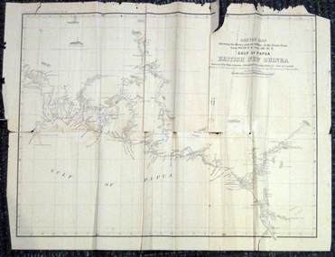
Map, British New Guinea, 1893, 1893
The map was surveyed by ship compass, distances by estimation or rate of launch by officers of the Government ; supervised and compiled by J.B. Cameron, G.S. March 1893. This map was in the possession of Charles Carty Salmon (1860-1917), politician, born on 27 July 1860 at Amherst, Victoria. (http://adb.anu.edu.au/biography/salmon-charles-carty-8328 ) Although living in Melbourne Charles Carty Salmon kept property at Talbot. The property was leased, then purchased by the donor's family. A copy of "The Goulburn Weir and its Dependent System of Works" and this map (in a government envelope addressed to Salmon) were left at the property. See http://nla.gov.au/nla.map-rm1894-1 .1) Sketch map showing the rivers and an outline of the coast from Long. 144?30'E. to Long. 146?30'E. Gulf of Papua British New Guinea Scale [ca. 1:316,800]. .2) Large envelope addressed to The Hon Charles Carty Salmon M.P., Talbot, Victoria. The map was folded and stored in this envelope. Map extending from Port Bevan to Kaikavau Pt, showing rivers and notes on soil and vegetation. Relief shown by hachures and spot heights. Also available in an electronic version via the Internet at: http://nla.gov.au/nla.map-rm1894-1 .1) "Enclosure in Despatch No. 32 of 3rd May 1893 - Appendix G.". "Map no. 4 British New Guinea report 1892-93". .2) "This envelope can only be lawfully used by Government Officials on public business. Any use by Officials on private business, or by others under any circumstances, is punishable." "Commonwealth Celebrations. General Secretary's Office, Melbourne."carty salmon, charles carty salmon, new guinea, j.b. cameron -
 Federation University Historical Collection
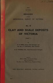
Book, Memoirs of the Geological Survey of Victoria; No 18, Clay and Shale Deposits of Victoria, 1952
Grey soft covered book with red tape spine. The 76 pages clay deposits, composition of Victorian clays, clay localities, granitic clays, Residual Clays, Clay-Shales, Jurassic clay shales.r a keble, senior field geologist, j c watson, chief chemist, d e watson, chief government geologist, g c moss, minister of mines, mallee plains, avoca valley, loddon valley, campaspe valley, goulburn valley, kiewa, mitta, glenelg valley, pitfield valley, otway area, moorabool valley, darley fireclay, campbellfield clay, latrobe river valley, hendley, ball clays, felspars, pegmatities, quartz, pakenham fireclay, bulla china clay, kaolin, terracotta, stoneware, ballan dyke-belt, egerton, gordon, ballan, llandeilo, colbrook, elaine, lal lal, maryborough, ballarat, ringwood, siliceous clay, stawell, dromana, ptways, bulla, pyalong china clay, linton china clay, wedderburn clays, lal lal china clays, ballan dyke belt, reginald callister, knight's koalin pottery, china clay, ferdinand krause, clarendon, bittern, frichot, hunt's dam, vaughan, rosenow, hickey, malone, claypits, ballarat dyke belt, stawell dyke belt, maryborough dyke belt, guildford, daylesford, ovens valley -
Tatura Irrigation & Wartime Camps Museum
file, State Rivers & Water Supply Commission
This collection was owned by Keith Daniel, an accountant with SR & WSC. Resident in Tatura 6-7 years until 1965File containing - Victorian Government Gazette March 6, 1968. - - Map, Goulburn Irrigation System - Murchison A, SR & WSC Journal "Aqua" April 1966 , Lake Eppalock Boating Guide, "Aqua Summer 1991, Brochure & newspaper adv. re: Waranga Lakeside estate.1974 -
Tatura Irrigation & Wartime Camps Museum
Photograph, Goulburn Waranga Main Channel Construction, 1957
Photo taken by the photographer for Victoria State Rivers and Water Supply Commission of the Goulburn Waranga main channel in 1957.Large black and white photograph - dry mounted to cream board. Channel excavation scene with excavator, bucket upraised, in right foreground. Two men looking at something, left foreground. Two small figures mid distance.Below photo: "Goulburn Waranga Main Channel Construction / Bucyrus 200 W. Excavator with 6 c. yd. Bucket / Looking towards off-take at Goulburn Weir / Completed Excavation in Background.goulburn, waranga, irrigation, photo, victoria state rivers and water supply commission -
Tatura Irrigation & Wartime Camps Museum
Photograph, Goulburn Waranga Main Channel Construction, 1957
Photo taken by the photographer for Victoria State Rivers and Water Supply Commission of the Goulburn Waranga main channel in 1957.Large black and white photograph - dry mounted to cream board. Channel excavation scene - with excavator bucket in operation, right foreground. Two men, one arm raised, pointing, in left foregroundBelow photo: "Goulburn Waranga Main Channel Construction / Bucyrus 200 W. Excavator with 6 c. yd. Bucket / Looking towards off-take at Goulburn Weir / Completed Excavation in Background.goulburn, waranga, irrigation, photo, victoria state rivers and water supply commission -
Tatura Irrigation & Wartime Camps Museum
Photograph, Goulburn Waranga Main Channel Construction, 1957
Photo taken by the photographer for Victoria State Rivers and Water Supply Commission of the Goulburn Waranga main channel in 1957.Large black and white photograph - dry mounted to cream board. Channel excavation scene - with excavator bucket in operation / Man operation machine right foreground / Several small indistinct figures mid distance working in channel bed.Below photo: "Goulburn Waranga Main Channel Construction / Bucyrus 200 W. Excavator with 6 c. yd. Bucket / Looking towards off-take at Goulburn Weir / Completed Excavation in Background.goulburn, waranga, irrigation, photo, victoria state rivers and water supply commission -
Tatura Irrigation & Wartime Camps Museum
Photograph, Goulburn Waranga Main Channel Construction, 1957
Photo taken by the photographer for Victoria State Rivers and Water Supply Commission of the Goulburn Waranga main channel in 1957.Large black and white photograph - dry mounted to cream board. Channel excavation scene - with excavator operating right mid distance, scoop bucket operating top of earth wall left mid distance, supervised by figure on top of earth wall.Below photo: "Goulburn Waranga Main Channel Construction / Bucyrus 200 W. Excavator with 6 c. yd. Bucket / Looking towards off-take at Goulburn Weir / Completed Excavation in Background."goulburn, waranga, irrigation, photo, victoria state rivers and water supply commission -
Tatura Irrigation & Wartime Camps Museum
Photograph, Goulburn Waranga Main Channel Construction, 1957
Photo taken by the photographer for Victoria State Rivers and Water Supply Commission of the Goulburn Waranga main channel in 1957.Large black and white photograph - dry mounted to cream board. Channel excavation scene - with excavator operating in mid distance, tractor with rooter in foreground.Below photo: "Goulburn Waranga Main Channel Construction / Channel excavation in progress / 200 W. Bucyrus Dragline, D.8 Caterpillar Tractor with rooter with "Gradall"goulburn, waranga, irrigation, photo, victoria state rivers and water supply commission -
Tatura Irrigation & Wartime Camps Museum
Photograph, 1936/02
Photo taken by the photographer for Victoria State Rivers and Water Supply CommissionMedium sized black and white photograph. Eildon Reservoir spillway / Concrete structure centre / rock and earth fill dam wall top half / round concrete tower left midway along wall bank.goulburn, irrigation, photo, victoria state rivers and water supply commission, eildon, eildon weir -
Tatura Irrigation & Wartime Camps Museum
Photograph, 1936
Photo taken by the photographer for Victoria State Rivers and Water Supply CommissionMedium sized black and white photograph. Eildon Weir spillway / Concrete structure of terraced steps and pylons supporting floodgates / rectangular tower on right / Dam water beyond at top of picture.goulburn, irrigation, photo, victoria state rivers and water supply commission, eildon, eildon weir -
Tatura Irrigation & Wartime Camps Museum
Photograph, 1936
Photo taken by the photographer for Victoria State Rivers and Water Supply CommissionMedium sized black and white photograph. Eildon Reservoir dam wall / rock and earth fill wall from above / round concrete tower lower left / water above right / tree covered hill topgoulburn, irrigation, photo, victoria state rivers and water supply commission, eildon, eildon weir -
Tatura Irrigation & Wartime Camps Museum
Photograph, 1936
Photo taken by the photographer for Victoria State Rivers and Water Supply CommissionMedium sized black and white photograph. Eildon Reservoir overall picture - Original reservoir and dam / rock and earth fill dam wall and construction huts left of centre / trees foreground / tree covered hills top left and across top / dam water / with leisure craft near wall.goulburn, irrigation, photo, victoria state rivers and water supply commission, eildon, eildon weir -
Tatura Irrigation & Wartime Camps Museum
Photograph, Goulburn Waranga Main Channel Construction, 1957
Taken by photographer for State Rivers and Water Supply Commission.Large black and white photograph dry mounted on to cream board. Landscape scene depicting newly excavated ground with solitary man within scene.Below photograph: "GOULBURN WARANGA MAIN CHANNEL CONSTRUCTION / CHANNEL EXCAVATION AND BEACHING / LOOKING DOWNSTREAM" victoria state rivers and water supply commission, goulburn waranga main channel, goulburn, waranga -
Tatura Irrigation & Wartime Camps Museum
Photograph, Goulburn Weir, 1890
Taken by photographer for State Rivers and Water Supply Commission.Medium sized black and white photograph. Earthworks foreground, horse and dray lower right, men working on concrete weir structures, middle distance, - river with tree'd banks beyond, workmen's huts and house left of middle distancevictoria state rivers and water supply commission, goulburn weir -
Tatura Irrigation & Wartime Camps Museum
Photograph, Goulburn Weir, 1890
Taken by photographer for State Rivers and Water Supply Commission.Medium sized black and white photograph. Earth and rubble bank bottom right corner - Concrete spillway and platform - overflow water in foreground - Trees on horizon - Dwelling left middle distancevictoria state rivers and water supply commission, goulburn weir -
Tatura Irrigation & Wartime Camps Museum
Photograph, Goulburn Weir, 1890
Taken by photographer for State Rivers and Water Supply Commission.Medium sized black and white photograph. View across weir - channel outlet left - earth and rubble wall separates two concrete and iron structures of weir. Trees on bank beyond beyond, buildings scattered amongst trees.victoria state rivers and water supply commission, goulburn weir -
Tatura Irrigation & Wartime Camps Museum
Photograph, Goulburn Weir, 1890
Taken by photographer for State Rivers and Water Supply Commission.Medium sized black and white photograph. View across weir showing partially completed channel outlet. Partially completed brick control building on top of wall joining the weir and channel outlets, hourse, cart, and driver bottom right.victoria state rivers and water supply commission, goulburn weir -
Tatura Irrigation & Wartime Camps Museum
Photograph, Goulburn Weir, 1890
Taken by photographer for State Rivers and Water Supply Commission.Medium sized black and white photograph. View from south of weir under construction Two carpenter's trestles foreground Trees in mid distance background Canoe in middle dry channel in foregroundvictoria state rivers and water supply commission, goulburn weir -
Tatura Irrigation & Wartime Camps Museum
Photograph, Goulburn Weir, 1890
... and Water Supply Commission. goulburn weir victorian state rivers ...Taken by photographer for State Rivers and Water Supply Commission.Medium sized black and white photograph. Water flowing through opened weir gates - over spillway - weir structure mid-distance. Trees beyond on far bank.goulburn weir, victorian state rivers and supply commission -
Tatura Irrigation & Wartime Camps Museum
Photograph, Goulburn Weir, 1890
... and Water Supply Commission. goulburn weir victorian state rivers ...Taken by photographer for State Rivers and Water Supply Commission.Medium sized black and white photograph. Water teeming down spillway of concrete weir structure - concrete and iron walkway above. Trees on far bank beyond. Close up photographgoulburn weir, victorian state rivers and supply commission -
Tatura Irrigation & Wartime Camps Museum
Photograph, Goulburn Weir, 1890
... and Water Supply Commission. goulburn weir victorian state rivers ...Taken by photographer for State Rivers and Water Supply Commission.Medium sized black and white photograph. View of concrete and steel weir structure - with water cascading down the spillway steps from West side. Thick foliage beyond on East bankgoulburn weir, victorian state rivers and supply commission -
Tatura Irrigation & Wartime Camps Museum
Photograph, Goulburn Weir, 1890
... and Water Supply Commission. goulburn weir victorian state rivers ...Taken by photographer for State Rivers and Water Supply Commission.Medium sized black and white photograph. Newly completed diversion channel and weir looking north. Brick control building and two men on right - trees foreground and on East bank oppositegoulburn weir, victorian state rivers and supply commission