Showing 195 items matching "greensborough railway"
-
 Greensborough Historical Society
Map, Melbourne and Metropolitan Board of Works. Survey Division, MMBW, Yarra 2500 / 12.20. Watsonia Railway Station and environs, 1983_03
Melbourne and Metropolitan Board of Works. Yarra 2500 [base map]. 12-20, Parishes of Keelbundora 2856, Municipalities of Diamond Valley 257 and 228. Shows street names, easement sizes, lot numbers, lodged plan numbers, names of prominent features, contour values, creek or river names. Watsonia Railway Station and environs. Prominent streets: Watsonia Road, Elder Street, Morwell Avenue and Nepean Street. Includes former Watsonia Technical School and Gresswell Rehabilitation Centre sites.MMBW Map in 1:2500 [scale] series. Cream parchment with green tape reinforcing on edges and punched holes on left edge.mmbw, melbourne and metropolitan board of works, shire of diamond valley, watsonia - maps -
 Greensborough Historical Society
Map, Melbourne and Metropolitan Board of Works. Survey Division, MMBW, Yarra 2500 / 12.22. Watsonia North, 1978_03
Melbourne and Metropolitan Board of Works. Yarra 2500 [base map]. 12-22, Parishes of Keelbundora 2856, Municipalities of Whittlesea 239 and Diamond Valley 257. Shows street names, easement sizes, lot numbers, lodged plan numbers, names of prominent features, contour values, creek or river names. Watsonia Railway Station and environs. Prominent streets: Edmund Rice Parade and Macorna Street. Includes Christian Brothers Edmund Rice College and Janefield Special School sites and "proposed future freeway" (now Metropolitan Ring Road).MMBW Map in 1:2500 [scale] series. Cream parchment with green tape reinforcing on edges and punched holes on left edge.mmbw, melbourne and metropolitan board of works, shire of diamond valley, watsonia - maps, bundoora - maps -
 Greensborough Historical Society
Map, Melbourne and Metropolitan Board of Works. Survey Division, MMBW, Yarra 2500 / 12.21. Watsonia North, 1979_02
Melbourne and Metropolitan Board of Works. Yarra 2500 [base map]. 12-22, Parish of Keelbundora 2856, Municipality of Diamond Valley 257. Shows street names, easement sizes, lot numbers, lodged plan numbers, names of prominent features, contour values, creek or river names. Watsonia Railway Station and environs. Prominent streets: Grimshaw Street, William Street and Macorna Street. Includes former Institute of Social Welfare (now Loyola College) Lines Reserve and Binnak Park.MMBW Map in 1:2500 [scale] series. Cream parchment with green tape reinforcing on edges and punched holes on left edge.mmbw, melbourne and metropolitan board of works, shire of diamond valley, watsonia - maps, bundoora - maps -
 Greensborough Historical Society
Map, Melbourne and Metropolitan Board of Works. Survey Division, MMBW, Yarra 2500 / 12.24. Plenty and Blue Lake, 1977_10
Melbourne and Metropolitan Board of Works. Yarra 2500 [base map]. 12-24, Municipalities of Whittlesea 239 and Diamond Valley 257. Shows street names, easement sizes, lot numbers, lodged plan numbers, names of prominent features, contour values, creek or river names. Watsonia Railway Station and environs. Prominent streets: Memorial Drive. Includes Plenty River and Blue Lake in the Plenty Gorge.MMBW Map in 1:2500 [scale] series. Cream parchment with green tape reinforcing on edges and punched holes on left edge.mmbw, melbourne and metropolitan board of works, shire of diamond valley, plenty - maps, blue lake -
 Greensborough Historical Society
Map, Melbourne and Metropolitan Board of Works. Survey Division, MMBW, Yarra 2500 / 17.26. Hurstbridge, 1978_01
Melbourne and Metropolitan Board of Works. Yarra 2500 [base map] 17-26. Hurstbridge. Municipalities of Diamond Valley 257 and Eltham 238. Prominent streets include: Flat Rock Road and Heather Avenue. Includes Hurstbridge Railway Station.MMBW Map in 1:2500 [scale] series. Cream parchment with green tape reinforcing on edges and punched holes on left edge.mmbw, melbourne and metropolitan board of works, shire of diamond valley, hurstbridge - maps -
 Greensborough Historical Society
Newspaper Clipping, Train works steam ahead, 05/06/2019
... Greensborough Historical Society 34A Glenauburn Road Lower ...Rail will be duplicated to Eltham and a major bus interchange created at Greensborough under a $547 million public transport cash splash.News article 1 page, black text.eltham railway duplication, greensborough -
 Greensborough Historical Society
Map, Heidelberg: Historic River Landscape Assessment. Historical maps. Map E 1901-1934 "A Time of projects and improvements", 1985c
Geographical area of around 35 sq. kilometres marked with physical features such as major roads, railways (new extension to Eltham), rivers and properties, also housing sub-divisions and community facilities such as hospitals, parks and sporting reserves and indications of new small scale industries such as dairying. Bounded by Shire of Diamond Valley to the North, Darebin Creek to the West and Plenty River to the East. Black and white sketch map on white paperheidelberg, heidelberg - maps -
 Greensborough Historical Society
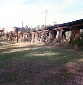
Photograph, Trestle Bridge Eltham April 1979, 17/04/1979
A photograph of the railway trestle bridge at Eltham. Built in 1902, it is the only railway bridge of predominantly timber construction that is still in regular use. The bridge is listed on the Victorian Heritage Database.1 colour photograph.peter graham, eltham, trestle bridge eltham -
 Greensborough Historical Society
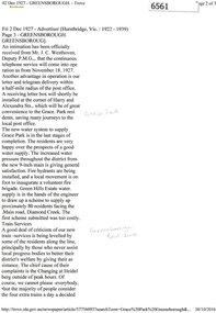
Newspaper Clipping (copy), Greensborough. 2 Dec 1927, 02/12/1927
Article describing new utilities in the Greensborough district: continuous telephone service; letter and telegram delivery within a half-mile radius of the post office; new water system to supply Grace Park, and plans to supply water to the Greenhills Estate, and comments on the train service from Heidelberg to Eltham.2 p. typescript (OCR transcript of original article, copied from Trove)water supply, postal services, railways, greenhills, grace park, telephone service, greensborough -
 Greensborough Historical Society
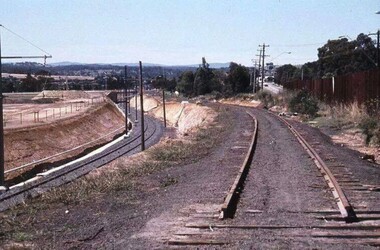
Photograph - Digital Image, Watsonia Station, 1978c, 1978c
Watsonia Station during the duplication of the train line c1978. This photograph shows the existing rail line and the construction of the new tracks in the cutting. Looking toward Grimshaw Street.Shows the rural nature of the Greensborough area in the early 20th centuryDigital copy of colour photograph. trains, watsonia railway station -
 Greensborough Historical Society
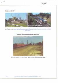
Article and Photograph, Watsonia station, 2016_
Photographs of the Watsonia station and surrounding train line during construction of the lowered train line - late 1970s.This text and photographs were copied from a Facebook site. Members are people who lived in the Greensborough area and share their reminiscences of the area with others. The site is administered by a GHS member but is not officially affiliated with the Society. Any information is the opinion of the contributor. Photographs and text sourced from social media.watsonia railway station, hurstbridge train line -
 Greensborough Historical Society
Folder, Peter Simmenauer, Building the Heidelberg to Eltham railway, by Peter Simmenauer, 2018
Background to the construction of the Heidelberg to Eltham railway extension, completed May 1902, written and collated by Peter SimmenauerFolder containing 4 p. article, copies of newspaper articles and contemporary documents and photographsrailways, hurstbridge rail line, heidelberg station, eltham station -
 Greensborough Historical Society
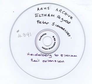
CD-ROM, Australian Railways Historical Society, Heidelberg to Eltham Railway: ARHS Archive, 30/01/2018
Report by Australian Railways Historical Society in response to a request for information on the Heidelberg to Eltham railway extension by Peter SimmenauerCD-Rom in plastic caseARHS Archive: Eltham Requestrailways, hurstbridge rail line -
 Greensborough Historical Society
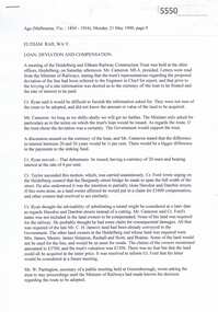
Newspaper Clipping, Eltham Railway: loan, deviation and compensation, 21/05/1900
Relates to the disagreement between advocates of the original surveyed route and the proposed "deviation" for the Heidelberg to Eltham railway extension, 1900.6 p. transcripts of newspaper reports from the Age 21/05/1900 and Mercury and Weekly Courier 13/07/1900 regarding discussions on the route to be taken by the Heidelberg to Eltham railway extensionrailways, hurstbridge rail line -
 Greensborough Historical Society
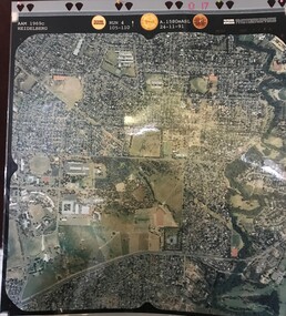
Aerial Photograph, AAM Photographics, Heidelberg AAM1969c 086, 24/11/1991
One of a series of four overlapping aerial photographs of the Heidelberg/Greensborough areas in 1991, covering Simpson Barracks, Macleod, Rosanna, Viewbank, Watsonia & Yallambie. North boundary Yallambie Road; West boundary Hurstbridge railway.Laminated colour aerial photographssimpson barracks, yallambie, watsonia, macleod, rosanna, viewbank -
 Greensborough Historical Society
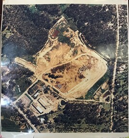
Aerial Photograph, AAM Photographics, Heidelberg AAM1969c 088, 24/11/1991
One of a series of overlapping aerial photographs of the Heidelberg/Greensborough area, covering Eaglemont, Heidelberg, Ivanhoe East & Viewbank. North boundary Hurstbridge railway, South boundary Ivanhoe East, East boundary Bulleen RoadLaminated colour aerial photographeaglemont, heidelberg, ivanhoe east, viewbank -
 Greensborough Historical Society
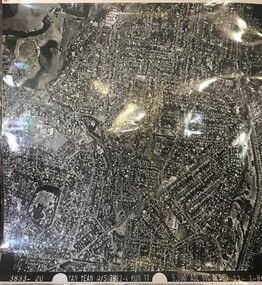
Aerial Photograph, Yan Yean M/S 7922 Run 17 No. 3833-20, 01/11/1984
Covers Rosanna and parts of Viewbank and Heidelberg. East boundary Price Park; West boundary Hurstbridge railway lineLaminated black and white aerial photograph; adjoins 6226 on east siderosanna, viewbank, heidelberg -
![Advertising Leaflet, Grace Park Electric Station Estate, Watsonia [1], 21/06/1924](/media/collectors/4f729f5697f83e03086015b8/items/5dcfb6fc21ea671434eb6c09/item-media/5dcfb72a21ea671434eb91fa/item-fit-380x285.jpg) Greensborough Historical Society
Greensborough Historical SocietyAdvertising Leaflet, Grace Park Electric Station Estate, Watsonia [1], 21/06/1924
Digital copy of auction leaflet for sale of land known as Grace Park Electric Station Estate, Saturday 21/06/1924. Auctioneer Knight & Harwood in conjunction with C. Jessop. This leaflet shows a home on the estate and a photograph of the proposed site of the 'Grace Park Railway Station'.Digital copy of auction leaflet 1 page. Black and red text on white paper.watsonia, grace park -
![Advertising Leaflet, Grace Park Electric Station Estate, Watsonia [2], 21/06/1924](/media/collectors/4f729f5697f83e03086015b8/items/5dcfb86d21ea671434eca90c/item-media/5dcfb88e21ea671434ecd037/item-fit-380x285.jpg) Greensborough Historical Society
Greensborough Historical SocietyAdvertising Leaflet, Grace Park Electric Station Estate, Watsonia [2], 21/06/1924
Digital copy of auction leaflet for sale of land known as Grace Park Electric Station Estate, Saturday 21/06/1924. Auctioneer Knight & Harwood in conjunction with C. Jessop. This leaflet features block plans and a railway line illustration showing the site of 'Grace Park Railway Station'.Digital copy of auction leaflet 1 page. Black and red text on white paper.watsonia, grace park -
![Advertising Leaflet, Grace Park Electric Station Estate, Watsonia [3], 21/06/1924](/media/collectors/4f729f5697f83e03086015b8/items/5dcfb9c821ea671434edd447/item-media/5dcfb9e821ea671434ededfc/item-fit-380x285.jpg) Greensborough Historical Society
Greensborough Historical SocietyAdvertising Leaflet, Grace Park Electric Station Estate, Watsonia [3], 21/06/1924
Digital copy of auction leaflet for sale of land known as Grace Park Electric Station Estate, Saturday 21/06/1924. Auctioneer Knight & Harwood in conjunction with C. Jessop. This leaflet shows a photograph of the 'Grace Park Railway Station' nearing completion.Digital copy of auction leaflet 1 page. Black and red text on white paper.watsonia, grace park -
 Greensborough Historical Society
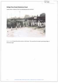
Article and Photograph, Bridge at Para Road and Gladstone Road, 2018_
... railway bridge greensborough... the railway bridge at Para Road and Gladstone Road Greensborough ...Information and photograph about the railway bridge at Para Road and Gladstone Road Greensborough.This photograph and text was copied from a Facebook site. Members are people who lived in the Greensborough area and share their reminiscences of the area with others. The site is administered by a GHS member but is not officially affiliated with the Society. Any information is the opinion of the contributor. Article and photograph sourced from social media.railway bridge greensborough, gladstone road briar hill, para road greensborough -
 Greensborough Historical Society
Article and Photograph, Hurstbridge Railway Line, 2016_
Information and photos about the Hurstbridge Rail Line, including a brief history of the line including dates on which upgrades to the line were made.This photograph and text was copied from a Facebook site. Members are people who lived in the Greensborough area and share their reminiscences of the area with others. The site is administered by a GHS member but is not officially affiliated with the Society. Any information is the opinion of the contributor. Article and photograph sourced from social media.hurstbridge rail line, greensborough station -
 Greensborough Historical Society
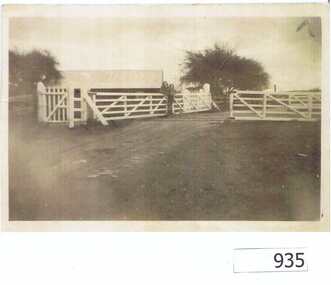
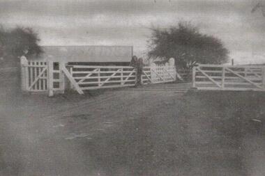
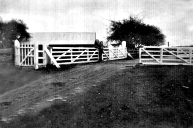
Photograph, Railway Gates at Grimshaw Street Greensborough, 1930c
Two women are standing at the railway crossing gates, ready to open or close the gates [Possibly Iredale family?]. Originally thought to be the rail crossing at Grimshaw Street and Old Greensborough Road. In 2023, there is doubt that this is the case due to the double rail line and building in background. Please contact the Society if you have any idea where this is located.Copy of photo of railway gates. Sepia.On back: "Godwill from Val Wilson"railway gates, rail crossing, iredale -
 Greensborough Historical Society
Photograph - Digital Image, Grimshaw Street rail crossing, 1930c
Two women are standing at the railway crossing gates, ready to open or close the gates [Possibly Iredale family?]. Originally thought to be the rail crossing at Grimshaw Street and Old Greensborough Road. In 2023, there is doubt that this is the case due to the double rail line and building in background. Please contact the Society if you have any idea where this is located.Digital copy of black and white photograph.railway gates, iredale -
 Greensborough Historical Society
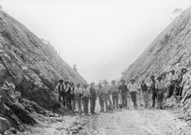
Photograph - Digital image, Railway construction 1902, 1902_
Photograph of workmen at a cutting along the Greensborough to Eltham rail line, 1902.Digital copy of black and white photograph.greensborough station, rail line -
 Greensborough Historical Society
Photograph - Digital Image, Grimshaw Street Railway Gates and Crossing Greensborough, 1930c
... Grimshaw Street Railway Gates and Crossing Greensborough... photograph. Grimshaw Street Railway Gates and Crossing Greensborough ...Two women are standing at the railway crossing gates, ready to open or close the gates [Possibly Iredale family?]. Originally thought to be the rail crossing at Grimshaw Street and Old Greensborough Road. In 2023, there is doubt that this is the case due to the double rail line and building in background. Please contact the Society if you have any idea where this is located.Digital copy of black and white photograph.rail crossing, iredale -
 Greensborough Historical Society
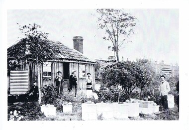
Photograph, Home of Mr Coghill Greensborough, 1910c
Shows the home of Mr Coghill which was the former Mitchell house located between the railway line and the Plenty River and directly opposite the end of Jessop Street.This shows the type of dwelling the early settlers lived in, also what they had in their cottage gardens.A rectangular black and white photograph of 4 men and 1 woman in a garden outside a shingle hut with bee hives near them.shingle hut, cottage garden, bee hives, coghill, mitchell, 1910 -
 Greensborough Historical Society
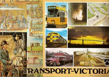
Book, Transport in Victoria, 1980s
Each of these booklets details the history, changes and upgrades to transport in Victoria in the early 1980s and explains the role af government authorities such as the Country Roads Board. Item 707c describes the Melbourne Freight Terminal between Spencer Street and Footscray Road.An historical look at the development of transport in Victoria.A collection of 3 booklets on transport in Victoria. Item 707a: 16 pages, colour illustrations. Item 707b: 20 pages, colour illustrations.Item 707c: 8 pages, black and white illustrations (20 x 14.5 cm). railways, transport, victoria, trams, roads -
 Greensborough Historical Society
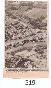
Newspaper clipping, Greensborough shopping centre 1970, 1970_
The photograph is of the centre of Greensborough in 1970, prior to the Greensborough Plaza being built. The Partington farm house, named 'Alwyn' (after Alan and Wyn Partington) can be seen north of the Railway Line. Alan and Wyn had to leave this farm in 1976 - moving to a new house - built by son Gary - at 54 Manatunga Circuit - to make way for the creation of Whatmough Park and development of the Hailes Street-The Circuit-Greensborough Plaza precinct.This is an important visual record of Greensborough before the redevelopment of the late 1970's. It also shows the Whatmough park area when it was still the Partington family farm.A black and white newspaper clipping featuring an aerial photograph.Nilgreensborough streets, greensborough, aerial photograph, 1970, partington, whatmough park, greensborough swimming pool -
 Greensborough Historical Society
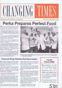
Newsletter, Changing Times, 30/01/1992
This is an issue of a weekly staff newspaper that was for employees of the Public Transportation Commission. .It features an article on Theo Tzaros the then Watsonia Station Master who was a guest radio announcer on the Plenty Valley Community Radio station 3PVR.A black and white 8 page newsletter with orange highlighting.Nil3pvr, plenty valley community radio, watsonia, station master, watsonia railway station