Showing 171 items matching "hillside"
-
 Clunes Museum
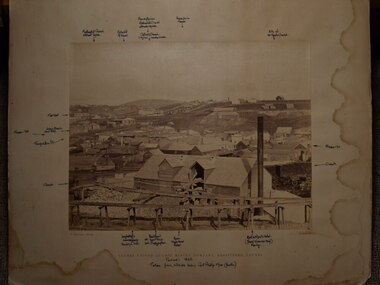
Photograph, C. NETTLETON, CIRCA 1865
SEPIA PHOTOGRAPH AND PHOTOCOPY OF CLUNES UNITED QUARTZ MINING COMPANY, TALL CHIMNEY ON RIGHT HAND SIDE.CLUNES UNITED QUARTZ MINING COMPANY REGISTERED CLUNES HANDWRITTEN NOTES: PERIOD 1865 TAKEN FROM HILLSIDE BELOW PORT PHILLIP MINE (SOUTH) LOCATIONS OF VARIOUS BUILDINGSlocal history, photography, photographs, mining -
 Benalla Art Gallery
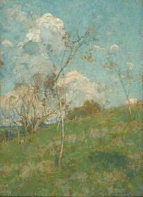
Painting, E. Phillips FOX, Autumn morning, 1900
Born: Fitzroy, Victoria, Australia 1865; Died: 1915ImpressionismBennett Bequest, 1998 Rural landscape with hill, trees, voluminous white clouds in the sky.Recto: Signed and dated "E. Phillips Fox / 1900" in blue paint l.l.c of composition; Not titledlandscape, rural, hillside, colonial, australian art -
 Hume City Civic Collection
Photograph, 1972
The photograph was taken during the 1972 Sunbury Pop Festival which was staged on a property owned by George Duncan. The site is on the banks of the Jacksons Creek between Sunbury and Diggers Rest.An aerial photograph of a crowd of people on a hillside and along a creek valley with a stage set up. On the LHS there is a large marquee surrounded by cars and pitched tents. There are trees around the creek and vast open paddocks in the distance.sunbury pop festival, jacksons creek, duncan, george, george evans collection -
 Ballarat Heritage Services
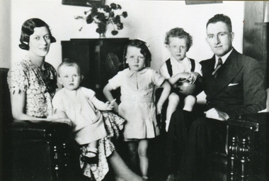
Photograph - Photograph - Colour, Carroll Family of Crossley, Victoria, 1937
Around 1941 this family left the farm at Crossley and moved to Melbourne, Victoria. Black and white photograph of members of the Carroll family of 'Hillside", McCartney's Lane, Crossley, Victoria. Left to right: Mary Carroll (Fitzgerald), Rosemary Carroll, Kathleen Carroll, Ronald Carroll, Patrick Edmund Carroll.kathleen carroll, mary carroll, mary fitzgerald, ron carroll, rosemary carroll, patrick edmund carroll, ronald carroll -
 Mt Dandenong & District Historical Society Inc.
Photograph
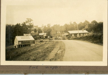
The image is from the album of Ivy Child and depicts the Five Ways intersection at Kalorama. Jeeves Motors, run by Hubert Jeeves is on the left hand side. The General Store that became a bank and now a gallery is to the right. The FiveWays Cafe is in the centre with the Mountjoy Guesthouse behind it. The photo would be from the late 1920s. Ivy May Child (1910 – 1989) was the daughter of Arthur Edward (Ted) Child (1878 – 1964) and Ethel May Madden (1888 – 1970). Ted Child was the son of Matthew Francis Child (1839 – 1933) and Martha Jeeves (1857 – 1926). He was the grandson of one of the early pioneers Francis Child. Ivy grew up on the family property on Childs Road and took many photographs. Most of these are glued into her photo album. The album covered the years from c1927 – 1932. Ivy married Henry William Burgess (1906 – 1968) in 1944. The photographs remain in their original state in the album with individual copies made. Sepia coloured photograph with a road in the foreground leading up to an intersection with buildinga on three corners. A large building visible on hillside behind. Six old cars are parked around the intersection. Bush is behind the photo.Written below image in album: FIVE WAYSjeeves motors, hubert jeeves, mountjoy, guesthouse, general store, fiveways cafe, fiveways, five ways, kalorama, cars, bank -
 Bendigo Historical Society Inc.
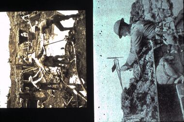
Slide - DIGGERS & MINING: THE DIGGERS, 1903
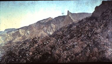
Diggers & Mining: The Diggers. Image of battle front, Diggers lay dying and dead on hill side. Hillside is very barren of vegetation. Markings: VISAR COPYRIGHT SET - THE DIGGERS, 7. Used as a teaching aid.Visaireducation, tertiary, diggers -
 Greensborough Historical Society
Letter, Brian Blackburn to Faye Fort, 1942o
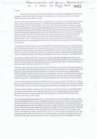
Letter from Brian Blackburn to Faye Fort, reminiscing about his childhood in Greensborough living on the property 'Hillside' at 3 St Helena Road [on the Corner with Diamond Creek Road].A personal memory of life in Greensborough, mid 20th century.Text of letter, typescript, 2 pages.greensborough, faye fort, brian blackburn -
 Victorian Interpretive Projects Inc.
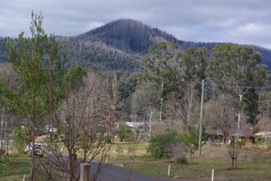
Photograph - Colour, Marysville after Black Saturday
In February 2009 bushfires devastated Marysville, resulting in in nation-wide support enabling a rebuilding programme. A number of colour photographs documenting the remarkable recovery of Marysville after the 2009 Black Saturday Bushfires. Badly burnt trees reshoot, houses are rebuilt, but black scars remain on hillsides where the heat was at its hotest.marysville, bushfire, regrowth -
 Bendigo Historical Society Inc.
Slide - DIGGERS & MINING: THE DIGGERS, c1900s
Diggers & Mining: The Diggers. 1st image (top) Diggers dug into hillside. 2nd image (bottom) Digger about to fly model aeroplane. Markings: VISAR COPYRIGHT SET - THE DIGGERS, 17. Used as a teaching aid.Visaireducation, tertiary, war -
 Lakes Entrance Historical Society
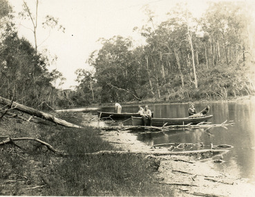
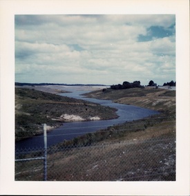
Photograph - North Arm, 1950c
Black and white photograph of the narrow upper reaches of the North Arm. It shows four people and dog at two small boats on bank. Steep tree covered hillsides above sandy shoreline. Lakes Entrance Victoria vegetation, waterways, recreation -
 Bendigo Military Museum
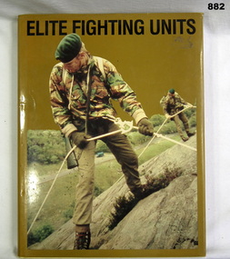
Book, David Eshel, Elite Fighting Units, c.1984
Book, yellow hard cover with khaki coloured dust jacket. Front of dust jacket has a photo of 2 green beret soldiers using ropes to descend a rocky hillside. Title in black print, 208 pages.books, military, history -
 Glenelg Shire Council Cultural Collection
Photograph - Reproduction Photograph - Bridgewater Lakes, 1920s
Black and white photograph (reproduction). Groups of men and ladies at Bridgewater Lakes, one group walking over a bridge made of sticks, one group either side of bridge, two ladies sitting on hillside above the bridgeFront: 'BRIDGEWATER LAKES' - bottom right Back: '848' in pencil -
 Halls Gap & Grampians Historical Society
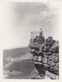
Photograph - B/W, C 1960s
Photo is of 'The Pinnacle' lookout with Lake Bellfield in the background flanked by the Mt. William range. the photo is typical of 'tourism' photos taken by the Victorian Railways.Photo shows a man and a woman on top of a rocky outcrop that overlook a valley. A lake with a dam wall and rock tiers cut into the hillside can be seen as well as cleared areas some buildings. the lookout is enclosed with a wire fence.scenery, lookouts -
 Southern Sherbrooke Historical Society Inc.
Photograph - Cardinia Reservoir filling, post 1973, Narre Warren East area
A set of five colour photos showing Cardinia Dam beginning to fill after its completion in 1973. One photo shows smoke or possibly dust rising on a distant hillside. The set was donated to the society by David Howe. -
 Bendigo Military Museum
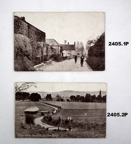
Postcard - POSTCARDS, ENGLAND, 2405.1 - 2405.4 S P Burt et al, c.1914 - 1918
Send from FRANK BARNES (AIF 4156) to UNA FRANKLING of Harcourt. 2405.9 The Rising Sun Fovant Camp (marked in chalk hillside) Refer Cat No 2380 for details re Frank Barnes service.Rectangular post cards, black & white photographs with over print descriptions of Sutton Veny England.documents - photographs, military history, photography -
 Bendigo Historical Society Inc.
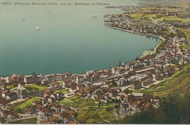
Postcard - ROY AND DORIS KELLY COLLECTION: PARCOURS MONTREUX-GLION, VUE SUR MONTREUX ET CLARENS, 1900-1920
Postcard, coloured photo of Montreux on the shores of Lake Geneva, Switzerland. The railway station in the centre is the start point for the Montreux to Glion walking trail. Photo taken on hillside overlooking Montreux and the suburb Clarens. Four sailing ships on the bay.postcard, photograph, postcard, montreux, lake geneva, clarens, switzerland -
 Lakes Entrance Historical Society
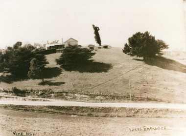
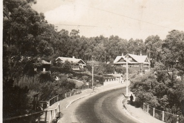
Photograph - Pine Hill Guesthouse, 1950c
Also second copy which is a very clear photo.Sepia toned photograph of Pine Hill Guesthouse, showing rambling building on top of hill, landmark tree, and pine trees on hillside. Road in foreground is Princes Highway. In far distance a glimpse of Cunninghame Arm. Lakes Entrance VictoriaPine Hill Lakes Entranceguesthouses, roads and streets, topography -
 Phillip Island and District Historical Society Inc.
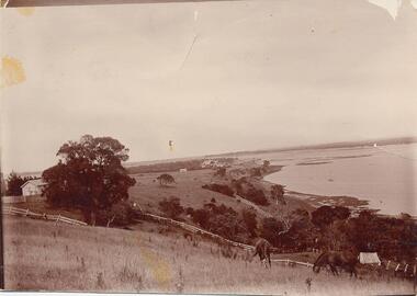
Photograph, Early 1900's
Donated by Jessie Smith (nee Small)Photograph of two horses grazing on hillside at Fiddlers Green, Griffiths Point (now San Remo) foreshore of Westernport. White fences dividing paddocks. School house on left behind trees and shed on right of photo. Houses and sea in background.horses grazing, phillip island, san remo, jessie smith, fiddlers green -
 Ballarat Heritage Services
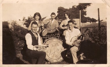
Photograph - Photograph - Black and White, Broadway Orchestra, Crossley, Late 1920s to early 1930s
Crossley's Broadway Orchestra. Three men and two women pose around a base drum belonging to the Broadway Orchestra. The man on the left holding a trumpet is Patrick Edmund Carroll of 'Hillside' Crossley, and from 1941 of Holden Street, North Fitzroy.broadway orchestra, crossley, crossly, victoria, patrick edmund carroll, band -
 Mt Dandenong & District Historical Society Inc.
Photograph, View From Corner of Doughty's Road and Barbers Road 1913
John Lundy-Clarke grew up in the Kalorama/Mt Dandenong area and later in life (1972-74) began to write a comprehensive history of the area working from an original settlement map in an effort to cover all areas. Taken c1913, this photograph gives a clear indication of where significant buildings were located in relation to one another. Barbers Road is running through the picture with the guest house 'Kia-Ora' , built by George Barber in the centre. High on the skyline on the left is the 'Mountjoy' guesthouse, indicating the location of The Gap, or FiveWays. The small 'boxy' house above 'Kia-Ora' is 'Iona' built by the Paynter family who also built 'Mountjoy'. The Jeeves property 'Kalorama' is to the right of 'Iona' and this is the area you now look to from the FiveWays Lookout. The man in the photo is wearing a trilby hat so is probably a Rose Series employee - a feature in many Rose Series postcards.Black and white photograph that is a copy of Rose Series Postcard # 156. A man can be seen walking down an unmade road with haystacks to his right. Buildings and crops can be seen on the hillsides. Handwritten inscription on reverse by John Lundy-ClarkeView from corner of Doughty’s and Barbers Road 1913. “Kia Ora” in centre Paynter’s “Iona” near center skyline above “Kia Ora” with “Kalorama” on its right and Peter’s hut of the time below it among orchard trees. “Mountjoy” is on left skyline. W. Haye’s home is centre left. Hay paddock is Barbers Lot 25 Village Settlement.kia-ora, iona, kalorama, mountjoy, guesthouse, guest house, barbers road, doughty's road, paynter, jeeves, george barber -
 Hume City Civic Collection
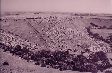
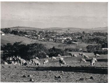
Photograph, Early 1970s
The photograph was taken when Sunbury township did not extend far beyond Anderson Road to the west and Powlett Street to the east. The Paynes housing development can be seen scattered across the hillside between Gap Road and Mitchells Lane.A black and white photograph of a panoramic view of Sunbury township looking west and taken from above the Goonawarra Winery. Sheep are grazing on the hilside in the foreground.sunbury township, goonawarra winery, george evans collection -
 Bendigo Historical Society Inc.
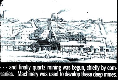
Slide - DIGGERS & MINING. THE GOLD ERA, c1880
Diggers & mining. The gold era. - - - and finally quartz mining was begun, chiefly by companies. Machinery was used to develop these deep mines. Slide shows a deep mine layed out on a hillside. Markings 32 994.031 GOL:5. Used as a teaching aid.hanimounteducation, tertiary, goldfields -
 Hume City Civic Collection
Photograph, 1980s
This photograph was taken from the intersection of Loemans and Sunbury Roads. It overlooks the site of the former Bula Primary School and the hillside where stones were laid and painted to form the words "Bulla". The lettering was possible a project carried out by the pupils at the school.A black and white photograph of a panoramic view overlooking the former Bulla Primary School. The photograph has been taken from the intersection of Loemans and Sunbury Roads.bulla primary school, bulla township, george evans collection -
 Lakes Entrance Historical Society
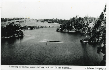
Photograph - North Arm, Bulmer H D, 1930c
Black and white photograph of the North Arm, showing the calm waters between steep banks covered in natural vegetation, but for one hillside which has been almost completely cleared, a few ring barked trees still standing. Lakes Entrance VictoriaLooking down the beautiful North Arm Lakes Entrancevegetation, waterways, topography -
 Hume City Civic Collection
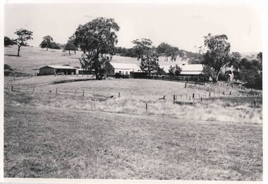
Photograph, Emu Bottom Homestead
The photograph was taken from the rear of the Emu Bottom Homestead and its outbuildings in front of the home paddock. George Evans, one of the district's earliest European settlers built the original homestead from Silurian sandstone removed from the surrounding hillsides in the 1830s.A black and white landscape photograph with a cream border of a farm house and outbuildingsemu bottom homestead, homesteads, george evans, jackson creek, sunbury -
 Clunes Museum
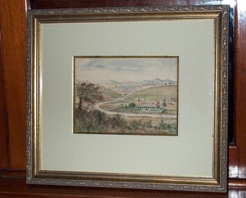
Artwork, other - PAINTING, PICTURE FRAMING. MALCOLM ROGERS, AUSTFRAMING 449 JOSEPH STREET, BALLARAT, CAMERON HOMESTEAD, C 1860
IT IS ON PERMAMENT LOAN FROM HEPBURN SHIRE THIS PICTURE WAS PAINTED FROM THE HILLSIDE, ACROSS THE CREEK FROM DONALD CAMERSON'S HOMESTEAD. 'THE CLUNES' NAMED AFTER HIS HOME IN SCOTLAND. DONALD CAMERON WAS AT CLUNES FROM 1839-1855, WHEN HE AND HIS FAMILY RETURNED TO SCOTLAND..1 FRAMED WATERCOLOUR OF THE CAMERON HOMESTEAD. .2 FRAMED PICTURE OF CAMERON HOMESTEAD (COPY OF ORIGINAL?) .3 PHOTOGRAPHED COPIES OF CAMERON HOMESTEAD (2) BLACK AND WHITE .4 COLOURED COPIES OF CAMERON HOMESTEAD (2)local history, illustration, watercolour, cameron of clunes -
 Bendigo Historical Society Inc.
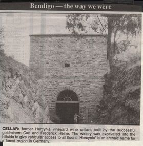
Newspaper - JENNY FOLEY COLLECTION: CELLAR
Bendigo Advertiser "The way we were" from 1999. Cellar: former Hercynia vineyard wine cellars built by the successful goldminers Carl and Frederick Heine. The winery was excavated into the hillside to give vehicular access to all floors. 'Hercynia' is an archaic name for a forest region in Germany.newspaper, bendigo advertiser, the way we were -
 Southern Sherbrooke Historical Society Inc.
Postcard - Postcard-original-Swans Bend Belgrave, Vic. c.1940s, A Bend In The Road, Belgrave
Sepia-toned postcard featuring bend coming into Belgrave Township from the west. Later known as Swans Corner. Dr Shirley Francis's house in centre of photo. Photo shows a hillside with three houses above the road. A man walks along the lower side of the road. c. 1920s. -
 Ithacan Historical Society
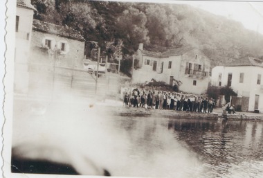
Photograph, Portside at Kioni, Ithaca, c1930s
Kioni is a small fishing village on Ithaca where caïque boats were used by fishermen and were once an important form of transport for goods and for people prior. The people in the photograph appear to be lined up along the water's edge awaiting a boat to arrive.A caïque (or kaiki) is a traditional handmade wooden fishing boat found among the waters of the Ionian or Aegean Sea and were once the main form of transport for the many Greek islands, moving people and goods across Greece's archipelago. In the 1980s and 1990s many were destroyed as a result of a European Union decision to subsidize fishermen to scrap their boats to tackle overfishing. Hundreds of beautiful and perfectly sound vessels ended up in landfills resulting in the loss of an integral part of Greece's long seafaring tradition and heritage. Sadly Cyclone Ianos which struck the island in September 2020 destroyed many of the remaining caiques on the island.A sepia photograph, which has a partial white border. The image has been affected by light across the bottom LH corner. The visible section shows a group of people lined up along the side of a wharf like structure. There are four two storey houses in the middle distance with a hillside in the background. -
 Ballarat Tramway Museum
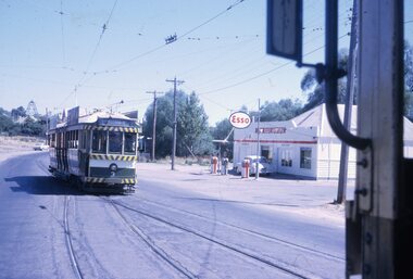
Slide - 35mm slide/s, Peter Moses, Jan. 1969
Photo of the SEC Bendigo No. 3 entering Long Gully Loop, bound for Eaglehawk, while another bogie tram waits in the loop. In the background is an Esso service station, known as Long Gully Motors, and a poppet head on a hillside in the background. Kodak cardboard mount slide, taken by Peter Moses, Jan. 1969.On the rear of the slide "P. Moses" in black ink and other side of the slide in red ink “4”.tramways, trams, bendigo, eaglehawk, long gully, esso, tram 3