Showing 2687 items
matching home building
-
 Eltham District Historical Society Inc
Photograph, Frank Stokes with his mother Florence (nee West) and children, Dorothy (left), David (centre) and Beryl (right), Stokes Orchard, Nyora Road, Eltham, c.1950, 1950c
... Orchard and building a home for his family, which they eventually... Orchard and building a home for his family, which they eventually ...Frank's mother Florence was visiting from England at the time. Frank Stokes first traveled to the district by train in 1944 to find land with the intention to establish an orchard. By chance he met Arthur Bird of Bird Orchard (bounded by Pitt Street, Eucalyptus Road and Wattle Grove) and they got talking over their common interest. Arthur put Frank up for the night and pointed out the land, part of Crown Allotment 15, Section 5, Parish of Nillumbik (CA15) somewhat diagonally opposite Bird Orchard. Frank bought the land and for the next two years would travel by train from Melbourne to Eltham every weekend establishing Stokes Orchard and building a home for his family, which they eventually moved into in 1946. In the mid 1970s the Shire of Eltham divided the orchard up into numerous rate-able parcel lots, which became affordable for Frank. As a consequence Stokes Orchard was turned into a housing development by Macquarie Builders and marketed as the Stokes Orchard Estate in two stages; Stage 1 encompassing Scarlet Ash Court, Ironbark Close and Peppermint Grove bounded by Nyora and Eucalyptus roads c.1976 and Stage 2 encompassing Stokes Place, Orchard Way, The Crest and The Lookout bound by Nyora and Diosma roads c.1979. The development of Orchard Way, The Crest and The Lookout did not proceed as planned due to the lack of the sewer along Diosma Road and so many of the proposed lots were incorporated into five-acre parcels instead.Representative of the orchard growing areas of ElthamDigital file only - Digitised by EDHS from a scrapbook (containing commercially printed photos of digital scans) on loan from Beryl Bradbury (nee Stokes), daughter of Frank Stokes.1950, beryl bradbury (nee stokes), beryl bradbury (nee stokes) collection, david stokes, dorothy stokes, eltham, flatbed truck, florence stokes (nee west), frank stokes, nyora road, stokes orchard -
 Eltham District Historical Society Inc
Photograph, The Stokes family home blanketed with snow, corner Nyora and Eucalyptus roads, Eltham, winter 1951, 1951
... Orchard and building a home for his family, which they eventually... Orchard and building a home for his family, which they eventually ...Taken from outside the family home on the southest corner of the intersection of Nyora Road and Pitt Street with Eucalyptus Road. Frank Stokes first traveled to the district by train in 1944 to find land with the intention to establish an orchard. By chance he met Arthur Bird of Bird Orchard (bounded by Pitt Street, Eucalyptus Road and Wattle Grove) and they got talking over their common interest. Arthur put Frank up for the night and pointed out the land, part of Crown Allotment 15, Section 5, Parish of Nillumbik (CA15) somewhat diagonally opposite Bird Orchard. Frank bought the land and for the next two years would travel by train from Melbourne to Eltham every weekend establishing Stokes Orchard and building a home for his family, which they eventually moved into in 1946. In the mid 1970s the Shire of Eltham divided the orchard up into numerous rate-able parcel lots, which became affordable for Frank. As a consequence Stokes Orchard was turned into a housing development by Macquarie Builders and marketed as the Stokes Orchard Estate in two stages; Stage 1 encompassing Scarlet Ash Court, Ironbark Close and Peppermint Grove bounded by Nyora and Eucalyptus roads c.1976 and Stage 2 encompassing Stokes Place, Orchard Way, The Crest and The Lookout bound by Nyora and Diosma roads c.1979. The development of Orchard Way, The Crest and The Lookout did not proceed as planned due to the lack of the sewer along Diosma Road and so many of the proposed lots were incorporated into five-acre parcels instead.Representative of the orchard growing areas of Eltham. One of the rare times it has snowed in ElthamDigital file only - Digitised by EDHS from a scrapbook (containing commercially printed photos of digital scans) on loan from Beryl Bradbury (nee Stokes), daughter of Frank Stokes.1951, beryl bradbury (nee stokes) collection, eltham, eucalyptus road, nyora road, snow, stokes family home -
 Eltham District Historical Society Inc
Photograph, The first houses in construction on the new Stokes Orchard Estate, July 1976, July 1976
... establishing Stokes Orchard and building a home for his family, which... establishing Stokes Orchard and building a home for his family, which ...Viewed from near the Stokes family home at 1 Nyora Road looking northeast across Ironbark Close to Scarlet Ash Court with Peppermint Grove in the distance. Frank Stokes first traveled to the district by train in 1944 to find land with the intention to establish an orchard. By chance he met Arthur Bird of Bird Orchard (bounded by Pitt Street, Eucalyptus Road and Wattle Grove) and they got talking over their common interest. Arthur put Frank up for the night and pointed out the land, part of Crown Allotment 15, Section 5, Parish of Nillumbik (CA15) somewhat diagonally opposite Bird Orchard. Frank bought the land and for the next two years would travel by train from Melbourne to Eltham every weekend establishing Stokes Orchard and building a home for his family, which they eventually moved into in 1946. In the mid 1970s the Shire of Eltham divided the orchard up into numerous rate-able parcel lots, which became affordable for Frank. As a consequence Stokes Orchard was turned into a housing development by Macquarie Builders and marketed as the Stokes Orchard Estate in two stages; Stage 1 encompassing Scarlet Ash Court, Ironbark Close and Peppermint Grove bounded by Nyora and Eucalyptus roads c.1976 and Stage 2 encompassing Stokes Place, Orchard Way, The Crest and The Lookout bound by Nyora and Diosma roads c.1979. The development of Orchard Way, The Crest and The Lookout did not proceed as planned due to the lack of the sewer along Diosma Road and so many of the proposed lots were incorporated into five-acre parcels instead.Housing development in Eltham as an extension to the Woodridge EstateDigital file only - Digitised by EDHS from a scrapbook (containing commercially printed photos of digital scans) on loan from Beryl Bradbury (nee Stokes), daughter of Frank Stokes.1976-07, beryl bradbury (nee stokes) collection, building construction, ironbark close, nyora road, peppermint grove, scarlet ash court, stokes orchard estate, houses -
 Eltham District Historical Society Inc
Photograph, Stokes family with horse and sled, Nyora Road, Eltham, c.1950, 1950c
... every weekend establishing Stokes Orchard and building a home... every weekend establishing Stokes Orchard and building a home ...Taken from outside the family home on the southest corner of the intersection of Nyora Road and Pitt Street with Eucalyptus Road, looking northeast across the Stokes Orchard Frank Stokes with children, Dorothy (left), Beryl and David Frank Stokes first traveled to the district by train in 1944 to find land with the intention to establish an orchard. By chance he met Arthur Bird of Bird Orchard (bounded by Pitt Street, Eucalyptus Road and Wattle Grove) and they got talking over their common interest. Arthur put Frank up for the night and pointed out the land, part of Crown Allotment 15, Section 5, Parish of Nillumbik (CA15) somewhat diagonally opposite Bird Orchard. Frank bought the land and for the next two years would travel by train from Melbourne to Eltham every weekend establishing Stokes Orchard and building a home for his family, which they eventually moved into in 1946. In the mid 1970s the Shire of Eltham divided the orchard up into numerous rate-able parcel lots, which became affordable for Frank. As a consequence Stokes Orchard was turned into a housing development by Macquarie Builders and marketed as the Stokes Orchard Estate in two stages; Stage 1 encompassing Scarlet Ash Court, Ironbark Close and Peppermint Grove bounded by Nyora and Eucalyptus roads c.1976 and Stage 2 encompassing Stokes Place, Orchard Way, The Crest and The Lookout bound by Nyora and Diosma roads c.1979. The development of Orchard Way, The Crest and The Lookout did not proceed as planned due to the lack of the sewer along Diosma Road and so many of the proposed lots were incorporated into five-acre parcels instead.Representative of the orchard growing areas of ElthamDigital file only - Digitised by EDHS from a scrapbook (containing commercially printed photos of digital scans) on loan from Beryl Bradbury (nee Stokes), daughter of Frank Stokes.1950, beryl bradbury (nee stokes), beryl bradbury (nee stokes) collection, david stokes, dorothy stokes, eltham, frank stokes, horse, nyora road, sled, stokes orchard -
 Eltham District Historical Society Inc
Photograph, Looking south towards Nyora Road, Eltham, 1977, 1977
... establishing Stokes Orchard and building a home for his family, which... establishing Stokes Orchard and building a home for his family, which ...Viewed from near the end of Stokes Place where the linear reserve now runs between 8 and 9 Stokes Place just visible through trees in foreground, 24 Nyora with red roof is the first house in middle of view. Frank Stokes first traveled to the district by train in 1944 to find land with the intention to establish an orchard. By chance he met Arthur Bird of Bird Orchard (bounded by Pitt Street, Eucalyptus Road and Wattle Grove) and they got talking over their common interest. Arthur put Frank up for the night and pointed out the land, part of Crown Allotment 15, Section 5, Parish of Nillumbik (CA15) somewhat diagonally opposite Bird Orchard. Frank bought the land and for the next two years would travel by train from Melbourne to Eltham every weekend establishing Stokes Orchard and building a home for his family, which they eventually moved into in 1946. In the mid 1970s the Shire of Eltham divided the orchard up into numerous rate-able parcel lots, which became affordable for Frank. As a consequence Stokes Orchard was turned into a housing development by Macquarie Builders and marketed as the Stokes Orchard Estate in two stages; Stage 1 encompassing Scarlet Ash Court, Ironbark Close and Peppermint Grove bounded by Nyora and Eucalyptus roads c.1976 and Stage 2 encompassing Stokes Place, Orchard Way, The Crest and The Lookout bound by Nyora and Diosma roads c.1979. The development of Orchard Way, The Crest and The Lookout did not proceed as planned due to the lack of the sewer along Diosma Road and so many of the proposed lots were incorporated into five-acre parcels instead.Housing development in Eltham as an extension to the Woodridge EstateDigital file only - Digitised by EDHS from a scrapbook (containing commercially printed photos of digital scans) on loan from Beryl Bradbury (nee Stokes), daughter of Frank Stokes.1977, beryl bradbury (nee stokes) collection, nyora road, stokes orchard estate, stokes place -
 Eltham District Historical Society Inc
Photograph, Stokes Place, Eltham, July 1977, July 1977
... Orchard and building a home for his family, which they eventually... Orchard and building a home for his family, which they eventually ...Viewed from near the end of Stokes Place where the linear reserve now runs between 8 and 9 Stokes Place looking slightly east of south towards Nyora Road. The new Christian Church on Nyora now the Baptist Church visible in middle view. Frank Stokes first traveled to the district by train in 1944 to find land with the intention to establish an orchard. By chance he met Arthur Bird of Bird Orchard (bounded by Pitt Street, Eucalyptus Road and Wattle Grove) and they got talking over their common interest. Arthur put Frank up for the night and pointed out the land, part of Crown Allotment 15, Section 5, Parish of Nillumbik (CA15) somewhat diagonally opposite Bird Orchard. Frank bought the land and for the next two years would travel by train from Melbourne to Eltham every weekend establishing Stokes Orchard and building a home for his family, which they eventually moved into in 1946. In the mid 1970s the Shire of Eltham divided the orchard up into numerous rate-able parcel lots, which became affordable for Frank. As a consequence Stokes Orchard was turned into a housing development by Macquarie Builders and marketed as the Stokes Orchard Estate in two stages; Stage 1 encompassing Scarlet Ash Court, Ironbark Close and Peppermint Grove bounded by Nyora and Eucalyptus roads c.1976 and Stage 2 encompassing Stokes Place, Orchard Way, The Crest and The Lookout bound by Nyora and Diosma roads c.1979. The development of Orchard Way, The Crest and The Lookout did not proceed as planned due to the lack of the sewer along Diosma Road and so many of the proposed lots were incorporated into five-acre parcels instead.Housing development in Eltham as an extension to the Woodridge EstateDigital file only - Digitised by EDHS from a scrapbook (containing commercially printed photos of digital scans) on loan from Beryl Bradbury (nee Stokes), daughter of Frank Stokes.1977-07, beryl bradbury (nee stokes) collection, eltham, eltham christian church, stokes orchard estate, stokes place -
 Eltham District Historical Society Inc
Photograph, Stokes family, Nyora Road, Eltham, c.1952, 1952c
... establishing Stokes Orchard and building a home for his family, which... establishing Stokes Orchard and building a home for his family, which ...Taken from outside the family home on the southest corner of the intersection of Nyora Road and Pitt Street with Eucalyptus Road, looking northeast across the Stokes Orchard L-R: David, Howard, Beryl (kneeling), Dorothy and Gladys Stokes with Gladys's mother sitting in Gladys's father's car with Spot the dog, Nyora Road, Eltham, c.1952 Frank Stokes first traveled to the district by train in 1944 to find land with the intention to establish an orchard. By chance he met Arthur Bird of Bird Orchard (bounded by Pitt Street, Eucalyptus Road and Wattle Grove) and they got talking over their common interest. Arthur put Frank up for the night and pointed out the land, part of Crown Allotment 15, Section 5, Parish of Nillumbik (CA15) somewhat diagonally opposite Bird Orchard. Frank bought the land and for the next two years would travel by train from Melbourne to Eltham every weekend establishing Stokes Orchard and building a home for his family, which they eventually moved into in 1946. In the mid 1970s the Shire of Eltham divided the orchard up into numerous rate-able parcel lots, which became affordable for Frank. As a consequence Stokes Orchard was turned into a housing development by Macquarie Builders and marketed as the Stokes Orchard Estate in two stages; Stage 1 encompassing Scarlet Ash Court, Ironbark Close and Peppermint Grove bounded by Nyora and Eucalyptus roads c.1976 and Stage 2 encompassing Stokes Place, Orchard Way, The Crest and The Lookout bound by Nyora and Diosma roads c.1979. The development of Orchard Way, The Crest and The Lookout did not proceed as planned due to the lack of the sewer along Diosma Road and so many of the proposed lots were incorporated into five-acre parcels instead.Representative of the orchard growing areas of ElthamDigital file only - Digitised by EDHS from a scrapbook (containing commercially printed photos of digital scans) on loan from Beryl Bradbury (nee Stokes), daughter of Frank Stokes.1948-1951 vauxhall velox, 1948-1951 vauxhall wyvern, 1952, beryl bradbury (nee stokes), beryl bradbury (nee stokes) collection, david stokes, dorothy stokes, eltham, gladys stokes, nyora road, spot (dog), stokes orchard -
 The Beechworth Burke Museum
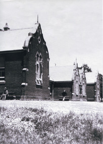
Photograph, c. 1900
... of the Ovens Benevolent Home with one person sitting on a bench seat... of the Ovens Benevolent Home with one person sitting on a bench seat ...This black and white photograph shows the front view of the Ovens Benevolent Home with one person sitting on a bench seat against the nearest part of the building and another person walking on the grass. This photo is estimated to have been taken in the early 1900’s when the Ovens Benevolent home would have still been fairly contemporary. According to Woods (p. 121) in the 1860’s the government spent considerable sums to establish several public buildings such as the Benevolent Asylum, the Hospital and Insane Asylum to support those in need of care in the area directly after the Indigo gold rush which had left Beechworth, a fairly remote regional and newly formed township (Gold was first discovered in Beechworth in 1852) with a number of infirm and destitute people in its wake and which due to the support and establishment of these facilities ‘made Beechworth a significant social welfare centre in Victoria’ (Woods, p. 121). Originally named the Benevolent Asylum, the building was renamed as The Ovens Benevolent Asylum in 1935 and again to The Ovens and Murray Home in 1954. The building construction began in 1862 and was unique in its features of Flemish Gothic Revival style which utilised red brick and granite, ‘the main facade is dominated by four curved, Flemish gable ends, […] incorporates paired windows of pointed Gothic form and dark brick diaperwork patterning. The adjacent J. A. Wallace Wing of 1899 was designed by Donald Fiddes as a separate building. Also constructed of red brick, Fiddes adopted a conservative approach, designing a simple domestic scale building with central projecting gable porch and flanking bull nosed verandahs.’ (https://vhd.heritagecouncil.vic.gov.au/places/118). Initially established to provide housing and care for aged, orphaned or widowed members of the population, over time the Ovens Benevolent Home focused more on the age care responsibility which functioned as such up until 2005.The Ovens Benevolent Home is significance due to its association with the early development of Beechworth. It shows the civic, social welfare development that took place in the town after the peak of the gold rush which helps to establish the character of the community being built at the time and their cultural values at play. This photograph also clearly shows the early functioning landscape of that building and its purpose as well as the significant elements of its aesthetic significance and unique and striking architectural forms of the building.Black and white rectangular photograph [copy from slide]Reverse: / 7588 /housing and care, aged care, donald fiddes, ovens benevolent home, flemish gable, brick diaperwork, photograph, black and white photograph, public building, benevolent asylum, indigo gold rush, beechworth, the ovens and murray home -
 Stawell Historical Society Inc
Archive - Document, Specification Documents Stawell hospital, 1933- 1980
... for Building nurses Home - 9 Specifactions New work Alterationsto... August 1954 - 8 Specifactions for Building nurses Home - 9 ...1933 - 1980 -1 Specifications New Hospital - 2 Specification of Excavation and Leveling. Febuary 1933 - 3 Specification of Enterane roadway. November 1933 - 4 Specifications Alterations and Additions. June 1940 - 5 Specification Repairs and External Painting - June 1940. Plus some tender application Letters - 6 Specifactions New Brick and Timber Linen Store. January 1943 - 7 New Nursing Home Construction - Bills of Quantities and Estimates August 1954 - 8 Specifactions for Building nurses Home - 9 Specifactions New work Alterationsto service Rooms. April 1955 - 10 Specifactions Nurses Home ( Timber Balustrades & Brick Retaining wall.) June 1956 - 11 Specifactions Labour and Materials Erecetion and Completion of Additions to Matron's Flat. August 1964 - 12 Specifactions of Work to be done and Materials to be use din Remodelling and Additions. October 1965. - 13 Specifaction for Supply & Installation of Hot Water, Heating & Air Conditioning Plant New Theatre Wing. November 1965 - 14 Specifaction of Remodelling and Additions at Stawell. New Geriatric Ward. November 1971 - 15 Specifactions of Electical Services at New Geriatric Ward November 1971 - 16 Specifaction for building works for Geriatric Day Centre Wing c1975 - 17 Specification Geriatric Day Centre Electrical Service. March 1975 - 18 Plans and Specifications for construction of Parking areas and Widening Existing Accress Road. April 1979 - 19 Specifications of Electrical Services for Lighting installations. January 1980 PLANS - 20 Male barthroom. July 1964 - 21 Additions to Matrons Flat - 22 Alteration Sketch Plan. June 1962 - 23 Approach to Sloane Street. September 1933 - 24 Hobart Food Services AM12 Series Washer pamphlet. - 25 Hospital Appeal Correspondance. October 1963.hospital -
 Eltham District Historical Society Inc
Photograph, The Stokes family home and orchard blanketed with snow, corner Nyora and Eucalyptus roads, Eltham, Winter 1951, 1951
... Orchard and building a home for his family, which they eventually... Orchard and building a home for his family, which they eventually ...Taken from outside the family home on the southest corner of the intersection of Nyora Road and Pitt Street with Eucalyptus Road. Frank Stokes first traveled to the district by train in 1944 to find land with the intention to establish an orchard. By chance he met Arthur Bird of Bird Orchard (bounded by Pitt Street, Eucalyptus Road and Wattle Grove) and they got talking over their common interest. Arthur put Frank up for the night and pointed out the land, part of Crown Allotment 15, Section 5, Parish of Nillumbik (CA15) somewhat diagonally opposite Bird Orchard. Frank bought the land and for the next two years would travel by train from Melbourne to Eltham every weekend establishing Stokes Orchard and building a home for his family, which they eventually moved into in 1946. Marjorie North remembered well the winter of 1951, when she took children, including son John together with the Shallard and Squire children “in the Austin A40 up the Main Rd., Eltham to farmer Bell’s property alongside the Eltham College. They were able to make a snow man and throw snowballs. (Diamond Valley News, August 5, 1986.p.42) In the mid 1970s the Shire of Eltham divided the orchard up into numerous rate-able parcel lots, which became affordable for Frank. As a consequence Stokes Orchard was turned into a housing development by Macquarie Builders and marketed as the Stokes Orchard Estate in two stages; Stage 1 encompassing Scarlet Ash Court, Ironbark Close and Peppermint Grove bounded by Nyora and Eucalyptus roads c.1976 and Stage 2 encompassing Stokes Place, Orchard Way, The Crest and The Lookout bound by Nyora and Diosma roads c.1979. The development of Orchard Way, The Crest and The Lookout did not proceed as planned due to the lack of the sewer along Diosma Road and so many of the proposed lots were incorporated into five-acre parcels instead.Representative of the orchard growing areas of Eltham. One of the rare times it has snowed in Eltham.Digital file only - Digitised by EDHS from a scrapbook (containing commercially printed photos of digital scans) on loan from Beryl Bradbury (nee Stokes), daughter of Frank Stokes.1951, beryl bradbury (nee stokes) collection, eltham, nyora road, eucalyptus road, snow, stokes family home -
 Kew Historical Society Inc
Biographical information, Ronald Horace Setford (1915–1988)
... . It was not until December 1945 that Ron started building their home.... It was not until December 1945 that Ron started building their home ...Ronald Horace Setford was born in April 1915 at 18 Church Street, Hawthorn, at his family’s home above their decorator shop. He was the second of three sons born to Horace Turner Setford (1880-1944) and Mabel Crofts (1887-1943). He attended Hawthorn West Primary School and then Swinburne before beginning work in his family’s business ‘Setford and Son’ in October 1930. This was formalised in April 1931 when he became a carpentry and joinery apprentice. In 1934 he graduated as a grade four carpenter. Ron worked in the family business until 1964 and then worked at J S Kidd and Co Pty Ltd as a storeman until his retirement in December 1973. Ron married Grace Muriel Agnes Perrey (1915-2001) in 1936 and they first lived in Kew around 1940, at 38 Marshall Avenue. Ron served in the Citizen Military Forces as a sapper with the 9 Australian Army Transport Company, Royal Australian Engineers, signing up a week after Darwin had been bombed. He spent time in Darwin, Wayville (South Australia), Herberton and Grovely (Queensland). Afterwards he refused to eat rice, never spoke of the war, nor took part in any ANZAC day proceedings. In 1941, Ron and Grace bought their block of land at 9 Tanner Avenue, East Kew, part of the Old Golf Links Estate, for £225. It was not until December 1945 that Ron started building their home and they moved in during May 1947. Ron and Grace remained there for thirty-seven years until the house was sold to their nephew in 1984. It has since been demolished. Ron’s great passion was photography and in the early 1960s he purchased his Minolta camera. Slide evenings at Tanner Avenue were a regular occurrence. Ron made his own title slides, interval slides and end slides. As well as many holiday photos (around Australia and their world trip in 1966), he enjoyed photographing local landmarks, flowers, insects and family. One of Ron’s photography projects was to record the progress of the building of the Eastern Freeway. This was near their home, and he’d walk down to the works on a regular basis, dressed smartly, with his camera in hand. The workers thought he was an official photographer, and he was allowed on site to take his photos. In 1984, Ron and Grace downsized and moved to Bayswater. Ron passed away on 31 October 1988 at the Maroondah Hospital in Ringwood East, at age 73. His ashes were spread on his beloved rose bushes at Tanner Avenue. Lauren Thomson, 2025ron setford, 9 tanner avenue -- kew east (vic, setford and son -- 18 church st (hawthorn), grace muriel agnes perrey, 9 australian army transport company, j s kidd and co pty ltd, eastern freeway, f19 freeway -
 Eltham District Historical Society Inc
Photograph - Digital Photograph, Marguerite Marshall, Jelbart home, 93 Arthur Street, Eltham, 11 November 2006
... of most building materials, they followed the example... of most building materials, they followed the example ...Situated at the top of the hill in Arthur Street, the former Jelbart residence and barn were part of a major change that transformed Eltham's character in the late 1960s. Built from the mid 1940s through mid 1950s when Eltham was a rural community, the Jelbrat residence and barn are all that remain of a family property of some 250 acres (100 ha). With growing population pressures, in the late 1960s, owners Ron and Yvonne Jelbart decided to subdivide their property creating the Woodridge Estate in the early 1970s, a major factor towards the transformation of Eltham to the suburb it is today. The Jelbarts had moved to Eltham in the early 1940s when they purchased a poultry farm in New Street, now Lavendar Park Road. (The local Black Friday bushire of January 13, 1939 had started at C.A. (Clarrie) Hurst’s Eltham Poultry Farm and Hatchery in New Street.) Jelbart was primarily a businessman importing office machinery but desired farm beef and dairy cattle so the couple purchased the virgin bushland at what was then at the end of a dirt road, Arthur Street. With post war shortages of most building materials, they followed the example of the Eltham Artists' Colony (later called Montsalvat) and built thier home from mud-bricks and recyclked materials. The barn was first to be completed in 1945 which they made their home whilst building the main residence. It took eight years to complete the two buildings. Both the main residence and the barn are now separate homes, and along with the remaining property being sub-divided further in 1998 are now part of the Kinloch Gardens Estate at 93 Arthur Street. Covered under Heritage Overlay, Nillumbik Planning Scheme. Published: Nillumbik Now and Then / Marguerite Marshall 2008; photographs Alan King with Marguerite Marshall.; p139 Standing on a hilltop at Arthur Street, Eltham, the Jelbart residence and former barn were part of a major change that transformed Eltham’s character in the late 1960s. Built from the late 1940s to the mid 1950s when Eltham was a rural community, they are all that remain of what was once a family property of around 250 acres (100 ha). As population pressure increased in the late 1960s, owners Ron and Yvonne Jelbart, decided to subdivide their property. The break-up of this property into the Woodridge Estate in the early 1970s, was a major factor towards transforming Eltham into the suburb it is today.1 Although standing only a few minutes from Eltham’s busy hub and hundreds of houses in Woodridge, scarcely any urban sound disturbs the peace. Views from the two buildings are almost exclusively of trees and extend to Mt. Dandenong to the south-east, the Great Divide to the north, and Melbourne city to the south-west. The Jelbarts had lived in Eltham since the early 1940s when they bought a poultry farm in New Street, now Lavender Park Road. Although Jelbart was primarily a businessman importing office machinery, he was keen to farm dairy and beef cattle, so the couple bought rough bushland at what was then the end of Arthur Street. But a shortage of building materials following World War Two hampered their plans to build their new home, so they followed the example of the Eltham Artists’ Colony (later called Montsalvat) and used mud-bricks and recycled materials.2 With great determination the family and friends constructed their house. Massive timber frames and huge quantities of mud-bricks were made on site. The barn was built first in 1945, and two years later, while camping inside, the Jelbarts started building their house. It took eight years to construct the two buildings, even with the help of professional tradesmen. The buildings, with timber frames infilled with mud-brick and plastered, are reminiscent of the English Tudor style. The Jelbarts are of Cornish stock. Much of the timber framework came from demolished bridges or warehouses, and recycled slate was used for roofs and floors. Quality second-hand materials were readily available in the late 1940s and 1950s when there was much demolition in Melbourne and little respect for heritage. A former 19th century Toorak mansion Woorigoleen provided the magnificent stone fireplace, the timber panelling and the parquetry floor in the living room. The large stone gateposts at the entry of the property came from Melbourne University. Almost no mechanical equipment was used to build the 55 square house and the 25 square barn. Massive timber frames were erected using block and tackle pulleys and timbers were shaped, sawn and drilled by hand. Son and architect Ian, with his family, have lived in and extensively renovated both buildings since the early 1970s. Ian transformed the steep ridge of the property into a plateau, where the main house Kinloch stands, surrounded by terraces and lawns. The grounds retain many native plants, including massive yellow boxes – some nudging 80 years. Ian attached 70 metres of pergolas draped with wisteria, roses and grape vines, to three sides of the house. The beautiful garden is featured in the book Through the Rose Arbour by Rosemary Houseman. The two-storey barn – now a house – retains traces of its original use. The cow-shed with milking and feed-rooms, and the machinery-shed remain. The house, separated on the ground floor by a breeze-way, soars two storeys and includes a mezzanine. These are connected by spiral staircases, to timber-beamed and plaster-lined high-pitched ceilings. The house also descends to a wine cellar. Curiously the roof is of corrugated iron on the south and slate on the north, to save costs. Small-paned windows and three French doors open onto the front lawn, which extends to Jelbart Court.This collection of almost 130 photos about places and people within the Shire of Nillumbik, an urban and rural municipality in Melbourne's north, contributes to an understanding of the history of the Shire. Published in 2008 immediately prior to the Black Saturday bushfires of February 7, 2009, it documents sites that were impacted, and in some cases destroyed by the fires. It includes photographs taken especially for the publication, creating a unique time capsule representing the Shire in the early 21st century. It remains the most recent comprehenesive publication devoted to the Shire's history connecting local residents to the past. nillumbik now and then (marshall-king) collection, eltham, arthur street, jelbart barn, jelbart home, kinloch gardens -
 Old Colonists' Association of Ballarat Inc.
Photograph - Photograph - Colour, Ballarat Old Colonists' Association Homes, Charles Anderson Grove, Ballarat
... to the Association for the building of homes. The site was eventually... acceptable to the Association for the building of homes. The site ...HISTORY OF THE BALLARAT OLD COLONISTS' ASSOCIATION HOMES AT CHARLES ANDERSON GROVE, LAKE GARDENS One of the original objectives of the Association was “to provide the shelter of a house for those Pioneers of the Goldfields whom the reverses of fortune have deprived of the means of procuring the comforts of life in their declining years.” While the first home at Charles Anderson Grove was built in 1925 the Association had previously provided relief for needy pioneers from the time it was formed in 1883. Relief included monthly monetary payments, loads of firewood, medical assistance and distribution of Christmas boxes of groceries to deserving pensioners and in some cases payment of burial costs. Records indicate that in September 1922 three of the pensioners being assisted by the Association were accepted as residents in the newly erected Hassell Homes in Gillies Street (now demolished-opposite the High School). The first site for an Asylum for Indigent Members of the Old Colonists' Association was temporarily reserved from sale in October 1891. The site was approximately 28 acres in area in Mt Clear nearly opposite Midvale Shopping Centre in Main Road. The site was heavily timbered and when cleared over 260 tons of wood was sold to the Woah Hawp Gold Mining Company. A set of gates were erected but no homes built, although a plan for this reserve was drawn which showed twenty buildings ranging from one to four unit per building. The reserve was revoked in November 1909. The second site temporarily reserved in November 1909 as an Asylum was in Alfredton and consisted of some 7 acres and was adjacent to land reserved for an Abattoirs for the Ballarat Council. The reserve was revoked in February 1912 as it was deemed more appropriate to be added to the Abattoir site. Council suggested four (4) other sites in exchange for this land and they were inspected by the President, Vice President and Secretary on 22 December 1912. The first site inspected was land on the west side of Creswick Road opposite the brick kilns (now occupied by the showgrounds and oval). The land was described as being good quality, well fenced, no trees, good drainage and ample acreage but some distance from trams. The second site was Perry Park which was described as being good land, well fenced, having frontage to Gillies Street, good drainage and about 26 acres (but subsequently reduced to 10 acres). It was closely planted with Pinus Insignias and Wattle and had easy access from the Botanic Gardens tram. The third site was the North West portion of Victoria Park (corner of Sturt and Gillies Street) and was described as good land, well fenced and drained and well located. The fourth site was the South West corner of Victoria Park and known as Pound Paddock (corner of Winter Street and Gillies Street). It was considered to be low lying and too close to the Abattoir, and was also a considerable distance from trams. While the third site was recommended as the most suitable for the erection of homes it was considered unwise from the point of view as citizens to reduce the acreage of the park and therefore it was recommended that the Perry Park site be asked for as the most acceptable to the Association for the building of homes. The site was eventually temporarily reserved for an Asylum for Indigent Members of the Association in April 1914 with the gates from Mt Clear having been removed to the site a year earlier and eventually erected in 1917 for £12.10.0. In the same year the first 290 pine trees were advertised for removal in July and sold for £16. A sign indicating that the site was reserved for the erection of cottages was erected in September 1917. Stripping of the wattle bark (for tanning) and the cutting of the wood occurred in November 1918 with the land then being leased until it was required for the construction of the first homes in 1924. While the site was the third to be reserved it was the only one which was used for its intended purpose. It was named as Charles Anderson Grove in honour of Charles Anderson who joined the Association in 1918 and was President of the Association from 1942 to 1944. A number of cottages in the Ballarat Old Colonists' Association Retirement Village of Gillies Street, Ballarat.charles anderson grove, old colonists' club, ballarat, old colonists' association, old colonists' homes, retirement village -
 Old Colonists' Association of Ballarat Inc.
Photograph - Image, The History of Charles Anderson and Charles Anderson Grove, Ballarat
... to the Association for the building of homes. The site was eventually... acceptable to the Association for the building of homes. The site ...Information relating to Charles Anderson and Charles Anderson Grove, Lake Gardens, Ballarat. The Old Colonists' Association Ballarat Inc. is a not for profit charitable organisation providing accommodation for elderly people. It manages a 27 Home retirement village at Charles Anderson Grove, Ballarat. Accommodation is offered at significantly below market rates. It has been providing low cost accommodation to the elderly since the 1920s. The Association Council overseas the running of this facility on a voluntary basis. HISTORY OF THE BALLARAT OLD COLONISTS' ASSOCIATION HOMES AT CHARLES ANDERSON GROVE, LAKE GARDENS One of the original objectives of the Association was “to provide the shelter of a house for those Pioneers of the Goldfields whom the reverses of fortune have deprived of the means of procuring the comforts of life in their declining years.” While the first home at Charles Anderson Grove was built in 1925 the Association had previously provided relief for needy pioneers from the time it was formed in 1883. Relief included monthly monetary payments, loads of firewood, medical assistance and distribution of Christmas boxes of groceries to deserving pensioners and in some cases payment of burial costs. Records indicate that in September 1922 three of the pensioners being assisted by the Association were accepted as residents in the newly erected Hassell Homes in Gillies Street (now demolished-opposite the High School). The first site for an Asylum for Indigent Members of the Old Colonists' Association was temporarily reserved from sale in October 1891. The site was approximately 28 acres in area in Mt Clear nearly opposite Midvale Shopping Centre in Main Road. The site was heavily timbered and when cleared over 260 tons of wood was sold to the Woah Hawp Gold Mining Company. A set of gates were erected but no homes built, although a plan for this reserve was drawn which showed twenty buildings ranging from one to four unit per building. The reserve was revoked in November 1909. The second site temporarily reserved in November 1909 as an Asylum was in Alfredton and consisted of some 7 acres and was adjacent to land reserved for an Abattoirs for the Ballarat Council. The reserve was revoked in February 1912 as it was deemed more appropriate to be added to the Abattoir site. Council suggested four (4) other sites in exchange for this land and they were inspected by the President, Vice President and Secretary on 22 December 1912. The first site inspected was land on the west side of Creswick Road opposite the brick kilns (now occupied by the showgrounds and oval). The land was described as being good quality, well fenced, no trees, good drainage and ample acreage but some distance from trams. The second site was Perry Park which was described as being good land, well fenced, having frontage to Gillies Street, good drainage and about 26 acres (but subsequently reduced to 10 acres). It was closely planted with Pinus Insignias and Wattle and had easy access from the Botanic Gardens tram. The third site was the North West portion of Victoria Park (corner of Sturt and Gillies Street) and was described as good land, well fenced and drained and well located. The fourth site was the South West corner of Victoria Park and known as Pound Paddock (corner of Winter Street and Gillies Street). It was considered to be low lying and too close to the Abattoir, and was also a considerable distance from trams. While the third site was recommended as the most suitable for the erection of homes it was considered unwise from the point of view as citizens to reduce the acreage of the park and therefore it was recommended that the Perry Park site be asked for as the most acceptable to the Association for the building of homes. The site was eventually temporarily reserved for an Asylum for Indigent Members of the Association in April 1914 with the gates from Mt Clear having been removed to the site a year earlier and eventually erected in 1917 for £12.10.0. In the same year the first 290 pine trees were advertised for removal in July and sold for £16. A sign indicating that the site was reserved for the erection of cottages was erected in September 1917. Stripping of the wattle bark (for tanning) and the cutting of the wood occurred in November 1918 with the land then being leased until it was required for the construction of the first homes in 1924. While the site was the third to be reserved it was the only one which was used for its intended purpose. It was named as Charles Anderson Grove in honour of Charles Anderson who joined the Association in 1918 and was President of the Association from 1942 to 1944. CHARLES HENRY GRATTAN ANDERSON C.H.G. Anderson (Electoral Returning Officer) was elected to membership of the Old Colonists' Association, Ballarat, in October 1918. He was elected to the Association Committee in 1926, and appointed Treasurer of the Association on the resignation of F. Ellis until the end of the financial year in 1933. In 1936 Charles Anderson indicated he would not be available for the President's Chair and that he would retire from the Committee owing to pressure of work. C.H.G. Anderson was welcomed as a new member of the Association in 1938, and served as President of the Old Colonists' Association from 1942-1944. Midway through 1949 Charles Anderson was appointed Members Secretary and Manager of the Ballarat Old Colonists' Club at £5.0.0 per week and 10/- for entertainment, to commence work prior to 01 August 1949. He was to do 30 hours per week and be present on Friday and generally on Saturday nights. In 1957 a minute of sympathy was extended to Club Manager Charles Anderson on the loss of his son. In 1958 a bonus of £20.0.0 was paid to Charles Anderson in recognition of his service in assisting the Secretary/Manager taking over under difficult conditions. In March 1964 the Shire of Ballarat would not permit a private road to be named Anderson Grove as Anderson Street already existed in Ballarat but Charles Anderson Grove was deemed acceptable. A recommendation of the Committee was put to the AGM in 1967 that Charles Anderson be made a Life Member. In 1969 an Association meeting observed a minutes silence in memory of Chas Anderson. Charles Anderson was also a Committee member of Ballarat Mechanics' Institute from February 1940 to February 1970. He was President in 1948. Black and white photographic portrait of Charles Anderson.charles anderson, charles anderson grove, ballarat old colonists' club, old colonists' association, ballarat, ballarat mechanics' institute, hassell homes, woah hawp gold mining company, firewood, retirement village -
 Federation University Historical Collection
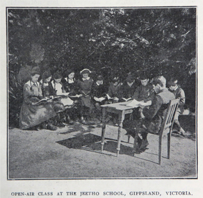
Book, Victoria Education Gazette and Teachers' Aid, 1911-1919, 1910-1919
... Bees, Tree Planting, fence building, Welcoming Home a Returned... Bees, Tree Planting, fence building, Welcoming Home a Returned ...Black hard covered book with red spine, holding Victorian Education Gazettes for one calendar year. .1) 1910 .2) 1912 .3) 1911 .4) 1914 .5) 1918 Images: Open Air Classroom Black Rock; Open Air Classroom, Jeetho, Gippsland; Open Air Nurses bedroom, Mildura; Gym at Canterbury School ; Babies and Nurses at Melbourne Foundling Hospital; Camp at Portland; Alexander Peacock Opens a Melbourne School; Unveiling Major Mitchell Memorial at Mt Arapiles; Agricultural Plot; School Interior; Swimming Drill; Graham Dux Prize Board; Bathing Place; Classroom with blackboard and pictures; Major Mitchell's Map; Melbourne, Derbyshire; Market Place Melbourne; The Blackwood; World War One Send-off at The Athenaeum; Scarsdale Old Boy's logo; Sloyd articles for the Field Hospital; World War One; Gifts for Transport to the Wharf; soldiers; ANZAC Day; ANZAC Day Medalion .5) 1915: Education Department's War Relief Fund, William Park obituary, Closer Settlement Act 1912, Agriculture, needlework, Swimming and Life Saving, explorers, Gregory Blaxland, Matthew Flinders, Composition, Geography, potatoes, onions, gardens, Needlework for Infants, Iona and Staffa, Trained Primary Teacher's Course, Electricity, Electrical Technology, hygiene, Arbour Day, Horticulture, Wattle Day, Bird Day, Technical Schools, Landing at Gaba Tepe, Evils of Alcohol, Old Boys of Scarsdale, Belgium, Teachers' College Images: The British at War, The Sonnet, History and Patriotism, Male Swimming Teachers Summer School at Geelong, Women Swimming Teachers at Port Fairy, Buln Buln State School, Burwood East State School, needlework plans, methods of Rescue and Resucitation. plan of the journey of Gregory Blaxland, Macquarie House, teachers killed (William Ross Hoggart, Stanley Robert Close, William Roy Hodgson, Campbell McDiarmid Peter, William Henry Dawkins, William Hugh Hamilton, Frederick McRae Neal, Vernon Brookes, Frank J. Olle, Alfred J. Collins, Ernest R. Fairlie, William J. McLaren, A.E. Smith, Thomas Patton, Francis W. Kemp, Frederick G. Hall, Rupert O. Hepburn, Woolston J. Govan), Frederick Harold Tubb VC, Botanic Gardens Red Gum, Shelter Pavillions, Head of Wheat, Australian Commonwealth Flag, Iona Cathedral, Drawing exercises, ANZAC Madallion, School Rolls of Honor .6) 1916 - Nature Study, war relief, school gardening, horticulture, singing class, geography of the war, School Rolls of Honour, Ponsonby Carew-Smyth, Astronomy, ANZAC Day, Empire Day, Arbor Day, "Some Suul of Goodness in Things Evil" by Frank Tate, War Relief Gardeners' League, ANZAC Day medallion, Solar System, Abolition of German Schools in Victoria, ANZAC Avenues, avenues of honour, Geography of the War: The West, War relief and handwork, Victorian State Schools Horticultural Society, Patrick Maloney obituary, formalin lamps, Victoria League of Victoria, Wonwondah East Roll of Honor Images - Teachers killed (John Clarke, A.C.H. Jackson, Alexander Robertson, Noel Gambetta, Ralp E. Leyland, Laurance J. Woodruff, Walter E. Cass, Percy D. Moncur, Thomas M. Carmichael, Edward G. Brain, Reginald N.F. Woods, George E. James, William Colvin, David Dobson, Stanley L. Robinson, Charles Allen, G.E. James, H.F. Curnow, Franl L. Cousins, James R. Thompson, Henry H. Campbell, George E. Read, Ernest D. Morshead, Wilfred S. Merlin, Henry R. Wright, George B. Webb, Noel Nicholas, David H. Thomas, Charles A. Levens, Thomas R. Fenner, John M. Daniell, P.J. Larkin, Ralph Smith, Philip Ormsby), school rolls of honour, Swimming Instructors at Queenscliff, The Southern Sky, Map of the North Sea and its Littorals, Easter School of Horticulture at Oakleigh, Map of the Eastern Front, Map of Mesopotamia, Map of the War Area in the Egyptian Campaign, leeches for the Melbourne Hospital .7) 1917 - Swimming and Life-Saving, Childre's FLower Day, Education Department's War Relief Fund, State War Council, Horticulture, Bird Day, Swimming, Growing Chicory at Cowes Images - Teachers killed during World War One (G.M. Nicholas, William C.W. Spencer, J.W.C. Profitt, Ivon C. Bromilow, John Colwell, Robert W. Campbell, Arthur P. Bourchier, Francid G. Houston, Claude N. Harrison, Edgar Williams, Leslie A. Stevens, Charles E. W. Chester, Stanley R. Green, Walter Baker, Arthur G. Scott, Harry L. Swinburne, Horace W. Brown, Arnold Bretherton, Edward W. Jenkins Aubrey Liddelow, Ewen A. Cameron, Edmund R. Lyall, John H. Martin, Harry Bell, Frank L. Nicholls, Melville R. Hughes, Edwin W. Hauser, Walter S. Filmer, Walter G. Barlow, Henry A. Donaldson, Edward H. Jones, Walter W. Raw, Alfred W. Dean, Wiliam Lea, Frederick G. Drury, J.T. Richards, Norman G. Pelton, Lance-Corporal Doran, Kenneth F. McKenzie, William F. Robertson, Wiliam Jarrott, Norman Graham, George G. Paul, Victor Green, Arthur William Rennie, Alfred J. Glendinning, Robert B. Liston, Eward P. Toll, George Jones, Errol E. Rodda, Christian P. Christensen, Charles F. Sydes, H.G. Clements, Norman C. Fricker, J.M. Romeo. Eric N. Lear, Thomas J. Bartley, Norval Birrell, Frederick H. Tubb. J.T. Hamilton Aram, Arthur Wilcock, William M. Conroy, Alex. H. Miller, Patrick J. Cunningham, Charles S. Mitchell, John R. Maddern, James Roadknight, Harry Arundel, Jack C. McKellar, duncan M. McKellar, George S. Manfield, Edgar C. Holmes, George A. Young, Raymond A. Gardiner, William B. Bell, William Opie, George R. Scott, Richard V.B. Vine, Herbery S. Marshall, Hugh St Omer Dentry, George B. Fullerton, Harry Oulton, Iva F. Morieson), School Honor Books, Drawing, Presentation of 30,000 pounds to the British Red Cross at Melbourne Town Hall .8) 1918 .9) 1919 - Photographs of World War One soldiers from the Education Department, Margaret Montgomery Memorial, 1918 Act relating to State School Teachers, State Scolarships, Victorian State Schools' Horticultural Society, Pneumonic Influenza, Spanish Flu, epedemic, swimming and life savinfJunior cadet training, vacancies in Fiji, School Committees, Arbor Day, Arbour Day, Henry Harding of Yinnar, Planting Trees and Shrubs, Juvenile Crime, The use of 'Get', Soldier-Teachers from Overseas in Congress London, Australia's Effort in the War, Military, Working Bees, Tree Planting, fence building, Welcoming Home a Returned Soldier, Avenue of Honour planting, Discipline, Unveiling an Honor Board, School gymnasium, school tennis court, E. E. Crogger grave at Aldershot, The School Honor Book. War Relief Fund, Commonwealth War Record, Caulfield Military Hosptial, ANZAC Day Pilgrimage, Jimmie Panikin, Donald Fraser, Arthur Mee, Card Sun Dial, Balboa Day in Honolulu, William Hamilton, Alfred Jackson, The Backward Child, Flies, Language Teaching and Learning, Spelling, The Education of the Adolescent, victorian education gazette, education gazette and teachers' aid, sloyd, william a. cavanagh, james i froebel, school, education, world war one, memorials, alfred williams, exploration and settlement, cadets, australian naval college, bernard o;dowd, birds, swimming, drawingempire league, eucalypts, paper in history, forestry, arbor day, identification of trees, forestrey museums, fiji, gravel hill school band, horticulture, hygiene, gould league of bird lovers, life saving, la perouse, bandin, j. holland, w. hamilton, charles sturt, principles of archimedes, james holland, william hamilton, scarsdale old boys' reunion, foundling home melbourne, montessori education, open air schools, james hughes, marie corelli, flinders sydney harbour, major mitchell's map, tooth brushing, r.h.s. bailey -
 The Beechworth Burke Museum
Photograph, c1970
The Beechworth Historic Courthouse is a living history museum in Victoria, Australia. Built in 1858, it has been in continuous service for 131 years and is currently home to a unique collection of artifacts, including its original furniture and fittings. The Courthouse Law Library is also recognised as being of outstanding national significance with many rare books held in the collection. The courthouse was built in 1858 and is located in the centre of the Beechworth Historic Precinct. It was built from granite with a double height gabled courtroom with the entrance via a central projecting porch. The building was classified in 1959 as part of Group Classification (B2615)with Forests Office, Lands Office, Police Lock-up & Police Station. The Courthouse is a significant site in Australia’s legal history because it was the location of more than 40 trials and hearings for the Kelly Gang and their sympathisers.This a rectangular, black and white photograph, unmounted.Reverse Ministry of Tourism, Melbourne1850s beechworth, beechworth courthouse, ned kelly, 1800s beechworth, kelly gang, beechworth historic courthouse, 1858, kelly trials, daniel kelly, dan kelly, edward kelly, ellen kelly, elizabeth scott, the first woman hanged in victoria, colony of victoria, 1863, domestic violence related murder -
 The Beechworth Burke Museum
Photograph, 1997
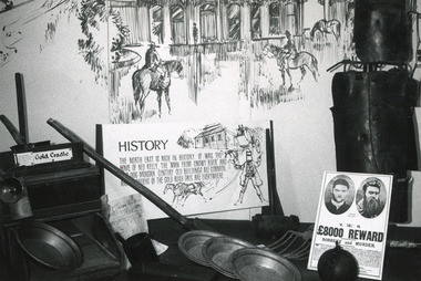
This photograph is recorded as having been taken in the North East Victoria Regional Tourist Authority, Wangaratta and depicts an exhibition display of items and interpretative labels associated with the Kelly Gang. The display was reportedly laid out as part of a Vic Tour Stamp, with items from the Burke Museum Collection.This photograph is of social significance due to its connection with the Burke Museum as well as the Kelly Gang. The Kelly Gang story is integral to the formation of the Australian identity and highlights the Irish oppression during the 1880s. Ned Kelly is an Australian icon, mythologised in Australian literature, art, folklore and history, and the Kelly Gang permeates Australia's national consciousness. The significance of the Burke Museum is also highlighted here, as the photograph shows the importance of the Kelly story to the Beechworth area and local identity, as well as its significance within the museum collection. The photograph is of strong research potential due to its depiction of the Kelly Gang history in Australia and its presentation of a historical museum exhibition which toured from Beechworth to other Victorian locations. With a depiction of the exhibition and associated label, the photograph provides insight into how the language and historical interpretation of Kelly Gang has developed, and how cultural and social opinions which are often shaped by exhibition displays, have shifted. Black and white rectangular photograph printed on matte photographic paper.Obverse: Gold Cradle / History / Claim 1835 / The north east is rich in history. It was the home of Ned Kelly, the 'Man from Snowy River' and (???) dog Mogan. Century old buildings are common and (???)nders of the gold rush days are everywhere / V. R. / £8000 Reward / Robbery and Murder / (indeterminate) Reverse: The historical display laid out in VICTOUR / 1997 3135 / North East Victoria/ Regional Tourist Authority/ P.O. Box 250/ Wangaratta. 3577 /BMMA03324burke museum, ned kelly, kelly gang, museum collection, exhibition, display, gallery, museum, exhibit -
 The Beechworth Burke Museum
Photograph, 1973
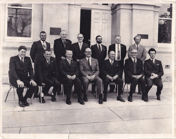
Taken in 1973, this photograph features 13 men in suits, most of whom are council members of the United Shire of Beechworth, as well as a secretary and engineer. The photo is taken in a formal setting, suggesting there may have been an occasion at this time (potentially surrounding or related to the August council meeting). Previously a district (1856), then a borough (1863) and separate shire (1866) at this time the Local Government Area (LGA) had been known by this name for approximately two years, after having amalgamated with the still-existing borough. Beechworth amalgamated with Rutherglen and Chiltern Yackandandah to become the Indigo Shire Council in 1994. Little has been found about the men in the photograph, however this was at also around the time that women were becoming more widely accepted into positions on Victorian council (such as Valerie Mason, who was elected the first President of the United Shire of Beechworth council 6 years after this photograph.) The photograph has been taken in front of the Beechworth Shire Hall. The Hall was designed by architects J.J. Coe and Thomas Dalziel and is dated to 1859. Originally the building was used as the Shire Offices but also doubled as a fire station and a courthouse, with still surviving cells underneath. The Town Hall is now home to the Visitor Information Centre, is the starting point for historical Precinct walking tours and is available for hire for events or community meetings.The Beechworth Town Hall is one of five distinctive granite buildings on Ford Street that comprise the Justice Precinct, and is listed on the Victorian Heritage register. This photograph captures the ongoing importance and use of the Beechworth Town Hall and its ties to Council operations in the 1970s.Black and white rectangular photograph print matt photographic paperReverse - written in pencil upper right corner: 1997.2602; stamped in black ink across centre margin: Beechworth shire council Aug.1973/ Crs.H.H.Warner, H.C.Lucas, L.W. Powell, L. Leentjes, R.C. Sewell, T.J. Carroll/ G.Gray (Secry), Crs.R.P. O'Connor, D. Nankervis, D. McKenzie-McHaig, J.J. Macaulay, H.R. Sinclair/ D.Pope (Engineer), Absent Cr.J.V.Diffey; written in pencil in cursive lower left margin: Absent J Diffey; written in pencil bottom right edge: BMMA02602beechworth shire council, crs.h.h.warner, h.c.lucas, l.w. powell, l. leentjes, r.c. sewell, t.j. carroll, g.gray (secry), crs.r.p. o'connor, d. nankervis, d. mckenzie-mchaig, j.j. macaulay, h.r. sinclair, d.pope (engineer), cr.j.v.diffey, beechworth town hall -
 The Beechworth Burke Museum
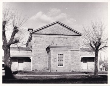
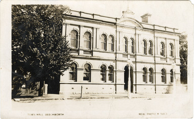
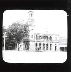
Photograph - Postcard, Town Hall Beechworth, c1910
Beechworth Town Hall was designed by architects J.J. Coe and Thomas Dalziel and is dated to 1859. The building was made of granite and constructed to local builders Donald and William Fiddes. The original front to the building was replaced by a two story facade in 1889 designed by George Jobbins and built by Thomas Sandham according to a plaque on the front. The Town Hall is remarkable for its vaulted ceilings and columns. Originally the building was used as the Shire Offices but also doubled as a fire station and a courthouse, with still surviving cells underneath. Among the inmates was notorious bushranger Harry Power who was originally transported to Van Dieman’s Land for stealing a pair of shoes. He gained his freedom six years later but spent time in and out of gaol for the rest of his life for a variety of offences including a number of armed robberies. The Town Hall is now home to the Visitor Information Centre which helps visitors with amongst other things, accommodation, tours, event enquiries, and is the commencement point for Precinct walking tours. The Beechworth Town Hall is one of five distinctive granite buildings on Ford Street that comprise the Justice Precinct. It is of considerable historical significance as activity on the site dates from Australia’s gold rush period and was the administrative centre for north-eastern Victoria. The building has seen continual use from 1858 as an important public building and displays many aspects of the history of law enforcement in Victoria. The building is also of substantial architectural significance for its construction from local honey coloured granite, which also showcases early stone masonry techniques and craftsmanship. The Precinct is listed on the Victorian Heritage register and is protected by Heritage Victoria under the Victorian Heritage Act 2017. The buildings are also registered by the National Estate, the National Trust and protected by Indigo Shire Council’s Planning Scheme. Black and White rectangular postcard printed on cardReverse: 1906-1910?beechworth, beechworth town hall, town hall, jj coe, thomas dalziel, granite, beechworth historic building, courthouse, cells, geoge jobbins, thomas sandham, 1859, 1889, walking tours, beechworth historic precinct, historic precinct, harry power, bushranger, australian bushrangers, van dieman's land, transportation, armed robberies -
 The Beechworth Burke Museum
Photograph
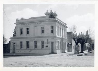
The old Bank of New South Wales building is located on the corner of Camp and Ford streets in Beechworth, Victoria. It was constructed between 1856 and 1857 from local honey coloured granite. It was designed by architects Robertson & Hale and is a two-storey rendered brick building and the original coat of arms is still visible. The coat of arms is distinctive and consists of a kangaroo, emu, lion, and rising sun. The rear of the building was surrounded by high granite walls for security as it was the original home for the local gold office. Beechworth Honey currently offers tourist accommodation in the Hive Apartment located in the former Bank of New South Wales Managers residence.The Bank of New South Wales building in Beechworth is significant for its location in one of Australia's most prominent goldfield towns. Of particular interest is the use of distinctive local Beechworth honey coloured granite in its construction. The building’s architecture is a simple, conservative classical style known as Renaissance Revival. It is one of the few known surviving works of the architects Robertson and Hale. The decorative composition above the main entrance and the counter in the banking chamber are of special interest.Black and white rectangular photograph printed on cardAHold bank of new south wales, bank of new south wales building, beechworth bank of new south wales, bank of nsw, beechworth 1850s, robertson and hale, architects robertson and hale, rendered brick, coat of arms, granite walls, local honey coloured granite, gold office, 1856, 1857, beechworth, beechworth honey, hive apartment, manager's residence, renaissance revival -
 The Beechworth Burke Museum
Photograph - Lantern Slide, c1900
This glass slide presents an image of the Old Beechworth Post Office and was taken in the year 1900. The building displayed within the image is not that of the post office in its original form; the post office originally consisted of only a simple wooden building. With the establishment and growth of new towns across Victoria, as well as an increased need for more consistent communications with the City of Melbourne, this modest building was soon deemed inadequate. In 1858 it was brought into the style of the changing times, with the tall clock tower added in 1865. This transition aligned with a pattern of refurbishment and conversion of many Beechworth buildings (which could be seen during the 1860s-70s), aiding in the growth and prosperity of the town. Early makeshift homes were turned into more substantial dwellings, featuring elements such as weatherboard, brick, and granites materials, and gabled or hipped roofs with iron lacework fringing the verandah. These refurbishments were temporarily halted in March of 1867 when a fire swept through the town, damaging many buildings including the post office. This led to further reconstructions on the building, including heightening of the clock tower, and in 1870 the two-storey Italianate style building was completed. The Old Beechworth Post Office itself also holds significance due to its connection with one of Australia's most infamous families. It reportedly played an important role in communicating the news of the 1880 murders of police at Stringybark Creek by the Kelly Gang. Lantern slides, sometimes called 'magic lantern' slides, are glass plates on which an image has been secured for the purpose of projection. Glass slides were etched or hand-painted for this purpose from the Eighteenth Century but the process became more popular and accessible to the public with the development of photographic-emulsion slides used with a 'Magic Lantern' device in the mid-Nineteenth Century. Photographic lantern slides comprise a double-negative emulsion layer (forming a positive image) between thin glass plates that are bound together. A number of processes existed to form and bind the emulsion layer to the base plate, including the albumen, wet plate collodion, gelatine dry plate and woodburytype techniques. Lantern slides and magic lantern technologies are seen as foundational precursors to the development of modern photography and film-making techniques. This glass slide captures social and historical significance as it displays the Old Beechworth Post Office in 1900, a building that demonstrates the prosperity and growth of Beechworth as a town during this time period. This slide also holds a level of aesthetic significance due to the Italianate style building that is featured in its image; a style that became very popular during the nineteenth-century. Thin translucent sheet of glass with a square image printed on the front and framed in a black backing. It is held together by metal strips to secure the edges of the slide.Obverse: x / burke museum, beechworth, lantern slide, slide, glass slide, plate, burke museum collection, photograph, monochrome, beechworth post office, beechworth post office kelly gang, 1900, 1900 beechworth, growth of beechworth, 1867 beechworth fire, old beechworth post office, beechworth post office reconstructions, italianate style, italianate style buildings, italianate style beechworth post office -
 Orbost & District Historical Society
black and white photograph, first half 20th century
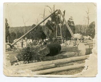
This photograph shows men working on cutting marble at South Buchan for Australia House in London. In the early 1900s black marble was being mined in the Bruthen district. Some was used for the Shrine of Remembrance in Melbourne and Australia House in London. 900 tonnes were shipped to London to be included in the construction of Australia House. DESCRIPTIONA paper covered booklet which is a pictorial souvenir Of Australia House in London. Pictures show Buchan marble features of the building.SIZE H-266mm W-192mm OBJECT REGISTRATION654KEYWORDSbuchan-marble australia-houseHISTORICAL INFORMATIONAustralia House is the oldest Australian diplomatic mission and it is the longest continuously occupied foreign mission in London. King George V laid the building’s first foundation stone in 1913 but it was not until August 1918 that he officially opened the completed building. The stringencies of World War I – principally shipping difficulties and labour shortages – had delayed construction considerably. Federation of the six Australian states formally took place on 1 January 1901 but it was not until 1906 that the Federal Government sent an Official Secretary to London to represent Australia. In the intervening years Australia was represented by State Agents-General, the first of whom was the Agent-General of Victoria. The building is significant for its unique design, Beaux Arts style and the materials used in its construction.Marble quarrying has been a significant part of the history of Buchan in East Gippsland. Its inclusion in Australia House in London and the shrine of Remembrance in Melbourne is noteworthy.A small black / white photograph of men in the background of a marble quarry. There is also a copy.on back - " Cutting Australian Home Marble at Sth Buchan"buchan-marble geology australia-house -
 Orbost & District Historical Society
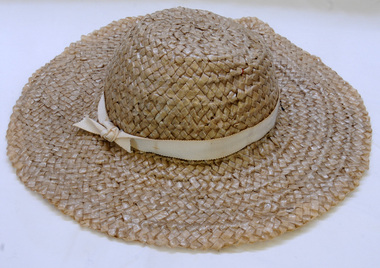
hat, Before 1953
Stuart Hats commenced manufacturing hats in about 1948 and closed their factory in Orbost around 1953 probably because of the high transport costs. The company's head factory was in Melbourne. The hats made in Orbost were sold all over Australia as well as in Melbourne at Myers and David Jones. Orme Andrews Ladies' Wear was the only store in Orbost to stock the locally produced Stuart Hats. The building became first a Dry Cleaners and then a private home.Stuart Hats was a significant manufacturing business in Orbost in the 1950's employing nearly 20 local people.A woven straw hat with a wide brim. It is a natural colour with braid as a hat band. Inside are two sewn on pieces for a pink tie.millinery stuart-hats clothing accessories hats -
 The Beechworth Burke Museum
Photograph
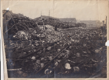
Taken some time between 1914-18 in France, the photograph depicts extensive wreckage of a railway train. There are collapsed buildings, debris, and helmets scattered all across the landscape. There is one unidentified soldier standing in the middle of the photograph. With research that is currently available, it can be inferred that the wreckage depicted in this photograph is from the tragic Saint-Michel-de-Maurienne derailment which occurred on December 12, 1917. The railway accident involved a troop train carrying almost 1,000 French soldiers on their way home for leave from the Italian Front in World War I. As the train descended into the Maurienne Valley, a sudden, uncontrollable acceleration caused a catastrophic crash and subsequent fire. 675 people died in the accident.The record is historically significant due to its connection to World War I. This conflict is integral to Australian culture as it was the single greatest loss of life and the greatest repatriation of casualties in the country's history. Australia’s involvement in the First World War began when the Australian government established the Australian Imperial Force (AIF) in August 1914. Immediately, men were recruited to serve the British Empire in the Middle East and on the Western Front. The record has strong research potential. This is due to the ongoing public and scholarly interest in war, history, and especially the ANZAC legend, which is commemorated annually on 25 April, known as ANZAC Day. Additionally, there is only limited information available about the Sant-Michel-de-Maurienne derailment. The record may be a useful springboard for further investigation into this accident and its history.Black and white rectangular photograph printed on matte photographic paper.Reverse: 6530 / Destruction of train carrying / German helmets (?) to (?) prior to / his retreat at Charleroi /military album, army, war, wwi, world war i, france, charleroi, train, military, wreckage, europe, belgium, saint-michel-de-maurienne, maurienne valley -
 The Beechworth Burke Museum
Photograph - Carte de Visite
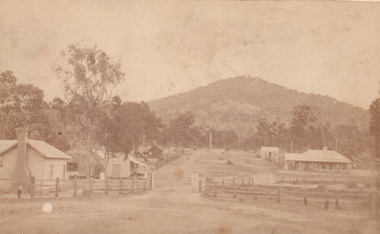
In July of 1880, Ann Jones' successful hotel in Glenrowan burnt to the ground during the Kelly siege. She had opened her business in the year prior having been unsuccessful in her attempt to run a tea-room business in Wangaratta. The first building on this particular site was the home Ann Jones had built for herself and her family. Two years later she converted the home and added the hotel to the rear of the structure. One year later it was burnt to the ground. This image depicts the streetscape of Glenrowan in 1883, three years after the siege. Importantly, it reveals the appearance of several buildings which can reveal information for how Glenrowan (as a small town) might have stood during the siege. These buildings are of typical Australian colonial "miner's cottage" style. On what would have been the site of Ann Jones' hotel, to the far left of the photograph, a police station stands. This police station was built before April 1883. This image was captured by an unknown photographer. This Carte-de-viste (CdV) previously belonged to the donor's grandfather, Daniel Mullins who was a Police Officer stationed at Glenrowan soon after the Kelly gang siege. Today, the siege has become an important part of Australian culture and Ned Kelly and the Kelly Gang (comprising of Ned Kelly, Dan Kelly, Steve Hart and Joe Byrne) has become ingrained in Australian history and mythology. A CdV is a sepia toned photograph mounted on card and is generally of a small size. This particular style was first patented by Andre Adolphe Eugene Disdéri (1819-1889) in 1854. In 1857, the CdV was introduced to England and after photographs of Queen Victoria, Prince Albert and their family were taken using CdV in 1860 the popularity of this method reached a peak.This photograph is part of the Burke Museum "Kelly album" which includes a significant collection of photographs and artefacts connected to Ned Kelly and the Kelly Gang. Ned Kelly and his gang have become ingrained in Australian popular culture and thus many museums, art galleries and private collections house material connected to the Kelly story which allows the events and people to be researched and interpreted. Artefacts and photographs pertaining to the Kelly gang are particularly valuable for Australian museums. This particular photograph is significant for its connection to the Glenrowan Siege and Ann Jones' Hotel which burnt down during the siege in June 1880. Taken in 1883, this photograph (taken by an unidentified photographer) has the opportunity to provide information about the townscape of Glenrowan shortly after the siege. It also provides important insight into the architecture and layout of the town. To the far right of the image, the photograph depicts the police station which was built on the site of Ann Jones' Hotel which can provide important information for the Kelly story and how the town evolved following 1880. It is also interesting to emphasise that the police station was built on the site of Ned Kelly and the Kelly gang's last stand.This photograph is a sepia image of the Glenrowan streetscape depicting several buildings. The newly built police station (in 1883) stands on the far right of the image on the site of the former Ann Jones Hotel. On the left are several buildings built in typical 'miner's cottage' Australian colonial style. This includes the gable roof with the skillion at rear. An unidentifiable individual stands next to the chimney of the front left building. Numerous paddocks appear in the image, particularly in the front right and the rear of the houses contain many trees. To the rear of the image, there is a mountain. A street runs through the centre of the photograph.Glenrowan / taken 1.4.83 ... / BMM 8086kelly album, ned kelly, glenrowan, police history, police, australian architecture, streetscape, glenrowan 1883, 1883, dan kelly, steve hart, joe byrne, carte-de-viste, james bray, daniel mullins, william e barnes, colonial australia, police station, photograph -
 The Beechworth Burke Museum
Photograph - Carte de Visite, William E Barnes
In July of 1880, Ann Jones' successful hotel in Glenrowan burnt to the ground during the Kelly siege. She had opened her business in the year prior having been unsuccessful in her attempt to run a tea-room business in Wangaratta. The first building on this particular site was the home Ann Jones had built for herself and her family. Two years later she converted the home and added the hotel to the rear of the structure. One year later it was burnt to the ground. This image depicts the streetscape of Glenrowan in 1883, three years after the siege. Importantly, it reveals the appearance of several buildings which can reveal information for how Glenrowan (as a small town) might have stood during the siege. These buildings are of typical Australian colonial "miner's cottage" style. On what would have been the site of Ann Jones' hotel, to the far left of the photograph, a police station stands. This police station was built before April 1883. This Carte-de-viste (CdV) taken by renowned Wangaratta based photographer William Edward Barnes previously belonged to the donor's grandfather, Daniel Mullins who was a Police Officer stationed at Glenrowan soon after the Kelly gang siege. Today, the siege has become an important part of Australian culture and Ned Kelly and the Kelly Gang (comprising of Ned Kelly, Dan Kelly, Steve Hart and Joe Byrne) has become ingrained in Australian history and mythology. A CdV is a sepia toned photograph mounted on card and is generally of a small size. This particular style was first patented by Andre Adolphe Eugene Disdéri (1819-1889) in 1854. In 1857, the CdV was introduced to England and after photographs of Queen Victoria, Prince Albert and their family were taken using CdV in 1860 the popularity of this method reached a peak.This photograph is part of the Burke Museum "Kelly album" which includes a significant collection of photographs and artefacts connected to Ned Kelly and the Kelly Gang. Ned Kelly and his gang have become ingrained in Australian popular culture and thus many museums, art galleries and private collections house material connected to the Kelly story which allows the events and people to be researched and interpreted. Artefacts and photographs pertaining to the Kelly gang are particularly valuable for Australian museums. This particular photograph is significant for its connection to Wangaratta based photographer William Edward Barnes and to the Glenrowan Siege and Ann Jones' Hotel which burnt down during the siege in June 1880. Taken in 1883, this photograph has the opportunity to provide information about the townscape of Glenrowan shortly after the siege. It also provides important insight into the architecture and layout of the town. To the far right of the image, the photograph depicts the police station which was built on the site of Ann Jones' Hotel which can provide important information for the Kelly story and how the town evolved following 1880. It is also interesting to emphasise that the police station was built on the site of Ned Kelly and the Kelly gang's last stand.This photograph is a sepia image mounted on yellow card which depicts the newly built police station (in 1882) which stands on the far right of the image on the site of the former Ann Jones Hotel. A fence appears through the lower front of the image and an open paddock is to the left. In the rear centre of the image, there is a mountain. In front of the mountain are many trees, most of them gum. The police station is a one storey structure with a veranda and there are three doorways visible in the image. The image depicts four windows on the front of the station.W.E.Barnes / photographer / Wangaratta / ...1882 / BMM8087kelly album, william barnes, wangaratta photographer, carte-de-viste, glenrowan, 1882, police station, ann jones inn, ann jones hotel, kelly siege, glenrowan siege, colonial australia -
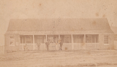 The Beechworth Burke Museum
Photograph - Carte de Visite, William E Barnes
In July of 1880, Ann Jones' successful hotel in Glenrowan burnt to the ground during the Kelly siege. She had opened her business in the year prior having been unsuccessful in her attempt to run a tea-room business in Wangaratta. The first building on this particular site was the home Ann Jones had built for herself and her family. Two years later she converted the home and added the hotel to the rear of the structure. One year later it was burnt to the ground. This image depicts the police station in 1882 on what would have been the site of Ann Jones' hotel. This Carte-de-viste (CdV) taken by renowned Wangaratta based photographer William Edward Barnes previously belonged to the donor's grandfather, Daniel Mullins who was a Police Officer stationed at Glenrowan soon after the Kelly gang siege. Today, the siege has become an important part of Australian culture and Ned Kelly and the Kelly Gang (comprising of Ned Kelly, Dan Kelly, Steve Hart and Joe Byrne) has become ingrained in Australian history and mythology. A CdV is a sepia toned photograph mounted on card and is generally of a small size. This particular style was first patented by Andre Adolphe Eugene Disdéri (1819-1889) in 1854. In 1857, the CdV was introduced to England and after photographs of Queen Victoria, Prince Albert and their family were taken using CdV in 1860 the popularity of this method reached a peak.This photograph is part of the Burke Museum "Kelly album" which includes a significant collection of photographs and artefacts connected to Ned Kelly and the Kelly Gang. Ned Kelly and his gang have become ingrained in Australian popular culture and thus many museums, art galleries and private collections house material connected to the Kelly story which allows the events and people to be researched and interpreted. Artefacts and photographs pertaining to the Kelly gang are particularly valuable for Australian museums. This particular photograph is significant for its connection to Wangaratta based photographer William Edward Barnes and to the Glenrowan Siege and Ann Jones' Hotel which burnt down during the siege in June 1880. Taken in 1882, this photograph has the opportunity to provide information about the townscape of Glenrowan shortly after the siege. It also provides important insight into the architecture and layout of the town. To the far right of the image, the photograph depicts the police station which was built on the site of Ann Jones' Hotel which can provide important information for the Kelly story and how the town evolved following 1880. It is also interesting to emphasise that the police station was built on the site of Ned Kelly and the Kelly gang's last stand.Sepia coloured photograph with a faded appearance. Image depicts four policemen with three standing and one sitting on a chair outside the Glenrowan police station. The station takes up the majority of the image and is placed in the centre of the photo. The four men are positioned on the left side of the station. The station is a large building with a gabled roof and extensions built into the veranda on either side. In between these extensions, the property has a white picket fence which runs from the extensions directly beneath the veranda enclosing the front of the structure. The letters 1, 2, 3, 4 are written on the yellow paper on which the image is situated and relate to the images in the photo. The reverse of the photo provides the names of each policeman and reveals the image as being from the collection of William E Barnes a Wangaratta based photographer.Obverse: 1. 2. 3. 4. Reverse: No. 1. is Mullins, D. G. / 2. Lord, Edward. / 3. Millar, Allex. / 4. Hedberg, O. G. / All Comrades / Glenrowan Police Station / 1 August 1882 / W. E. Barnes / Photographer / Wangaratta /kelly album, william barnes, wangaratta photographer, carte-de-viste, glenrowan, 1882, police station, ann jones inn, ann jones hotel, kelly siege, glenrowan siege, colonial australia, ned kelly, steve hart, joe byrne, william e barnes -
 The Beechworth Burke Museum
Photograph, J. Collins, c.1940-1950s
This photograph was captured sometime between an estimated 1940s-1950s. It depicts the Beechworth Benevolent Asylum (later the Ovens and Murray Hospital for the Aged) which was built in 1862. It is located on an elevated site in Beechworth, Victoria because it was believed the height was beneficial to the health of the patients at the Benevolent. Later wings were added to the original building between 1867 and 1890. The building was constructed in an unusual Flemish Gothic Revival style which contrasts with the classical style of the Mayday Hills Hospital in close proximity to the Benevolent. The Hospital was designed in Italianate Revival architecture. The appearance of buildings like the Mayday Hills Hospital and the Ovens Benevolent Asylum are representative of the importance of Beechworth as a town shortly after the goldrush. During the 1850s and 1860s, administration buildings were erected alongside churches, shops and structures of justice. This marks a movement away from the "chaotic" structure of life on the goldfields and towards a more civilised and cultural lifestyle. This social phenomenon is also witnessed in Melbourne with the creation of buildings like the State Library and the University of Melbourne. The Beechworth Benevolent Asylum was renamed the Ovens Benevolent Home in 1935. The Asylum had been set up to provide accommodation and care for permanently injured gold miners, and for women and children who were penniless, homeless, or whose parents were guests of the state. In 1954 it was renamed as The Ovens and Murray Home (as pictured in this photograph). The purpose of this building was to provide a refuge for the poor and destitute, homeless older men, deserted women and children along with providing care for the mentally ill. These buildings were built at the government's expense and are of great historical and architectural significance.This photograph depicts the Ovens and Murray Home (previously the Ovens Benevolent Home) during the 1940s or 1950s. Since this building is of great historic and architectural significance, photographs like this are especially valuable in reconstructing the use history and any changes/additions to the building over a period of time. This building is important for what it can reveal about society in Beechworth and also architectural styles. This building is made in the Flemish Gothic Revival style which is quite unusual for the 1860s. It is important as an early example of a building constructed for a specific purpose, in the case of this particular building: caring for the aged/destitute. This building is important for research into the civic development of Beechworth as an early Gold Rush town located in Victoria's North-East. During this period, Beechworth was developing as the main center of administration in this region which made it a very influential and quickly developed town. Photographs like this one which depict a building during one period in history can reveal important information for the use and alterations of a building and for preferences in architectural style. It can also be studied for what it reveals about society in Beechworth and compared and contrasted to similar institutions across Australia and with additional photographs in the Burke Museum collection.Black and white rectangular photograph printed on gloss photographic paperObverse: OVENS & MURRAY HOME / Reverse: KODAK PAPER / 727 / J. Collins BMM 8689.1 /mayday hills, beechworth benevolent asylum, ovens benevolent home, asylum, refuge, poor and destitute, goldrush, flemish gothic revival, architecture -
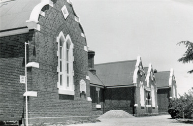 The Beechworth Burke Museum
Photograph, J. Collins
This photograph was captured sometime between an estimated 1940s-1950s. It depicts the Beechworth Benevolent Asylum (later the Ovens and Murray Hospital for the Aged) which was built in 1862. It is located on an elevated site in Beechworth, Victoria because it was believed the height was beneficial to the health of the patients at the Benevolent. Later wings were added to the original building between 1867 and 1890. The building was constructed in an unusual Flemish Gothic Revival style which contrasts with the classical style of the Mayday Hills Hospital in close proximity to the Benevolent. The Hospital was designed in Italianate Revival architecture. The appearance of buildings like the Mayday Hills Hospital and the Ovens Benevolent Asylum are representative of the importance of Beechworth as a town shortly after the goldrush. During the 1850s and 1860s, administration buildings were erected alongside churches, shops and structures of justice. This marks a movement away from the "chaotic" structure of life on the goldfields and towards a more civilised and cultural lifestyle. This social phenomenon is also witnessed in Melbourne with the creation of buildings like the State Library and the University of Melbourne. The Beechworth Benevolent Asylum was renamed the Ovens Benevolent Home in 1935. The Asylum had been set up to provide accommodation and care for permanently injured gold miners, and for women and children who were penniless, homeless, or whose parents were guests of the state. In 1954 it was renamed as The Ovens and Murray Home (as pictured in this photograph). The purpose of this building was to provide a refuge for the poor and destitute, homeless older men, deserted women and children along with providing care for the mentally ill. These buildings were built at the government's expense and are of great historical and architectural significance.This photograph depicts the Ovens and Murray Home (previously the Ovens Benevolent Home) during the 1940s or 1950s. Since this building is of great historic and architectural significance, photographs like this are especially valuable in reconstructing the use history and any changes/additions to the building over a period of time. This building is important for what it can reveal about society in Beechworth and also architectural styles. This building is made in the Flemish Gothic Revival style which is quite unusual for the 1860s. It is important as an early example of a building constructed for a specific purpose, in the case of this particular building: caring for the aged/destitute. This building is important for research into the civic development of Beechworth as an early Gold Rush town located in Victoria's North-East. During this period, Beechworth was developing as the main center of administration in this region which made it a very influential and quickly developed town. Photographs like this one which depict a building during one period in history can reveal important information for the use and alterations of a building and for preferences in architectural style. It can also be studied for what it reveals about society in Beechworth and compared and contrasted to similar institutions across Australia and with additional photographs in the Burke Museum collection.Black and white rectangular photograph printed on gloss photographic paperBack of photograph. Handwriting: "For John Beckingsale"mayday hills, beechworth benevolent asylum, ovens benevolent home, destitute, gold town, beechworth, victoria, north-east vic -
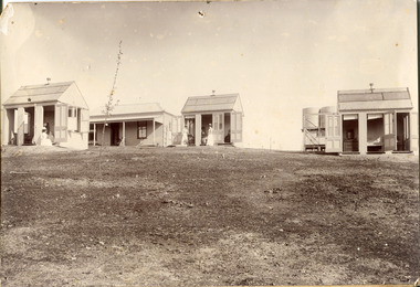 The Beechworth Burke Museum
Photograph
This photograph was captured in approximately 1900 and depicts the on site nurses homes. During the 1880s, these detached cottages were constructed and provided accommodation for the staff (in this case, the nurses) who lived within the hospital walls. Within the image are weatherboard buildings, a number of nurses and water tanks. Beechworth's Mayday Hills was chosen as the site of Victoria's newest asylum, at the time, due to the landscape and altitude. The hilltop atmosphere and the native fauna, it was argued, would assist in the cure of the patients kept at the hospital (Wood 1985, 122). The positioning of the hospital had a beneficial effect on the rural town. A pamphlet published by James Ingram and Son (1849) reveal that famous landmarks in Beechworth which included the Post Office, Gaol, Courthouse and Asylum "demonstrate the appreciation of Beechworth by the Government not only as as important district center, but also as a site unrivaled as a sanitarium". There were other locations in contention at the time, but ultimately Beechworth was chosen (Craig 2000, 33). Prior to the creation of the Asylum in Beechworth, those charged with having mental illnesses or, as it was termed, "insanity" were unable to be properly cared for in the Gaol (which is where they were often sent). John Buckley Castieau wrote, in 1861 for the Ovens and Murray Advertiser, that the Gaol was unable to properly care for those classified then as "insane" but that they would endeavor to treat them above the other inmates (which he notes is not always the case in other establishments). Castieau wrote this in favour of supporting the building of the Mayday Hills Hospital in Beechworth. It was stated that at the time the Mayday Hills Hospital was built, there were 83 prisoners kept in the Gaol who were to be rehoused to the Hospital on the grounds of "insanity". The classification as someone as "insane", in this period of time is a reflection on the inability to cure and understand illnesses of the mind during the mid to late 1800s. Opening on the 24th of October 1867, the Mayday Hills Hospital was originally named the "Ovens Lunatic Asylum", a title which is very much a product of its time. Whilst controversial, changes to the name is part of the history of the Hospital and can provide much insight into the understanding of mental illness throughout history and the use/disuse of this term provides information into the reception/changing opinions of mental illness in society. The Hospital would later become known as the "Mayday Hills Asylum" and/or "Mayday Hills Hospital" with the latter being the most commonly used title. An article in the Ovens and Murray Advertiser notes that on the 7th of March 1865, the foundation stone of the Hospital was laid (it would officially open in 1867) and that it was such a moment of accomplishment and joy for Beechworth that a letter to the editor even suggested that there should be a holiday dedicated to the day the foundation stone as laid. This reveals an extent to which the townspeople of early Beechworth valued the construction of the Hospital in their town. It provided the town with a sense of prestige and honour.At first glance, the remains of the Mayday Hills Hospital in Beechworth, Victoria, inspire tragedy, trauma and beauty. The buildings themselves, with their Italianate style Renaissance architecture designed by J.J. Clark (Craig 2000, 49 & Smith 2016, 203) reflect a bygone period of European and Australian history. The gardens provide a sense of tranquility and beauty. The experience of those within these walls remains a valuable area of study to provide a more complete understanding. This particular hospital is considered the fourth of its like and one of three identified as the largest of their kind. The Mayday Hills Hospital is a sister to the Kew and Ararat Asylums in Melbourne which are both located in relative proximity. Understanding the role of the Mayday Hills Hospital in Beechworth history is integral to understanding the development of the goldfields town, but also for providing important information as to the history of caring for, and the reception of, mental illnesses in Australian and wider European history. Mayday Hills provides a case study which can be researched through oral history, an analysis of the grounds/buildings and through images like these. Images like these depict the strong façade of the Hospital and provide a glimpse into the tranquility of the gardens. This has been done deliberately to provide a sense of comfort and healing about the building to those looking from the outside. Further research into the importance of the Hospital in Beechworth and it's connection to the town will be supported through images like these kept in the Mayday Hills photo album in the collection of the Burke Museum.Black and white rectangular photograph printed on photographic paper mounted on card"Early nurses quarters, Beechworth Mental Hospital, now May Day Hills Hospital."may day hills hospital, nurses quarters, beechworth, mayday hills, asylum