Showing 330 items
matching lagoon
-
 Port Melbourne Historical & Preservation Society
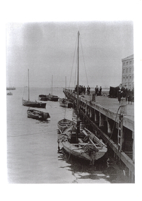
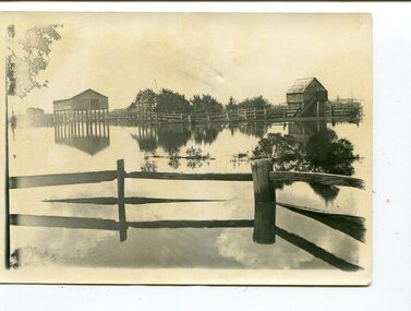
Photograph - Lagoon, Port Melbourne, 1905
Copy of B&W snapshot of Lagoon c1905, from Western Jetty looking towards the bay. Several small craft are moored in the lagoon. On rear: 'D Beazley photo collection Neg No PM004/2'sandridge lagoon, piers and wharves - lagoon pier -
 Glenelg Shire Council Cultural Collection
Photograph - Photograph - Fawthrop Lagoon, Portland, n.d
Black and white photo of the causeway across Wattle Creek end of Fawthrop Lagoon. Lagoon visible on left. Taken from bottom of Magazine Hill.Back: 'Causeway Portland' - handwritten, black inkfawthrop lagoon, portland -
 Phillip Island and District Historical Society Inc.
Photograph
One of a collection of over 400 photographs in an album commenced in 1960 and presented to the Phillip Island & Westernport Historical Society by the Shire of Phillip IslandPhotograph of McHaffie's Lagoon, Ventnor Phillip Island.local history, photography, black & white photograph, wetlands, john jenner, bryant west, mchaffie's lagoon -
Glenelg Shire Council Cultural Collection
Photograph - Photograph - Fawthrop Lagoon, n.d
Port of Portland Authority Archivesport of portland archives, fawthrop lagoon -
Port Melbourne Historical & Preservation Society
Card - Lagoon Confectionery, Spearmint, 1940s - 1950s
Bought by David ThompsonPoint of Sale card for Lagoon Confectionery. Spearmint.business and traders - confectioners, lagoon confectionery -
Port Melbourne Historical & Preservation Society
Photograph - The Lagoon, Port Melbourne, 1920s
Photographic copy of postcard: 'The Lagoon, Port Melbourne''40' on backsandridge lagoon, built environment - industrial -
Glenelg Shire Council Cultural Collection
Pamphlet - Brochure - Fawthrop Lagoon, the jewel in the heart of Portland, n.d
Brochure, natural colour, hand-made paper, dark blue and brown print. History of Fawthrop Lagoon AKA 'the Swamp'. Screen print of birds taking flight from Fawthrop's Lagoon on front cover, illustrations of birds and map of lagoon location on body of programme. -
Port Melbourne Historical & Preservation Society
Plan - Bridge over lagoon, Graham Street, Sandridge, Borough of Sandridge, 15 Oct 1878
Drawing of Graham Street bridge over the lagoon, 1878.Signed by E. Clark, Town Clerk, and Chas. Clay, Borough Surveyor.engineering - bridges, edward clark, town clerks, charles clay, graham street, sandridge lagoon -
 Bendigo Historical Society Inc.
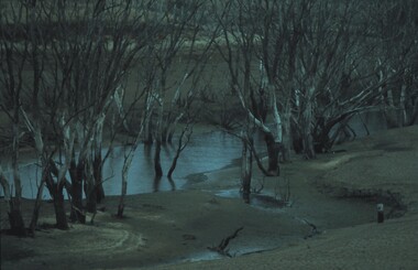
Slide - VAL DENSWORTH COLLECTION: DRY LAKE EPPALOCK, May 2004
Slide. Dry Lake Eppalock. A Lagoon in the river in the Lake.slide, bendigo, dry lake eppalock., dry lake eppalock. -
 Bendigo Historical Society Inc.
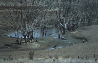
Slide - VAL DENSWORTH COLLECTION: DRY LAKE EPPALOCK
Slide. Dry Lake Eppalock. A small lagoon on the river.slide, bendigo, dry lake eppalock., dry lake eppalock. -
University of Melbourne, Burnley Campus Archives
Photograph - Black and white print, 2/3, 1942
Lagoon Paddock with Yarra Boulevard in the background. September 1942. lagoon paddock, yarra boulevard, e. m. gibson collection -
 Orbost & District Historical Society
black and white photographs, 1890s
Peter Cameron, came to Orbost in 1885, at the age of 69, having sold his farm at Geelong. Peter bought the property ―Glen Avon from a Mr Street. The home was situated at the bottom of the paddock, near the corner of Morley and Livingstone streets. The farm stretched from Tennyson Street to the end of Snaggers Lane and along the river frontage to “Carinya” Cameron Home. In the Gippsland Times on Wednesday. 2 Jul 1890 on Page 3 is an article titled "THE SNOWY RIVER CALAMITY" which describes an ".unexpectedly sudden rush of water down the flats..... the terrified people commenced to remove their stock from the land and the work of saving property was continued all day ............ many head of cattle were washed away.......The river road, for its entire length, is obliterated, and the approaches to the bridge at Watt's Gulch are gone, with the enormous volume of flood water," These photographs are pictorial records of a significant event in the history of Orbost. There are few personal records of the very early floods.Three black / white photographs of wooden buildings with flood water in foreground. There are post and rail fences. 3193.2 has been taken from a distance.on back -" "Glenavon east of Lagoon 1897 Feb"floods-orbost-1890s glenavon-orbost -
 Greensborough Historical Society
Photograph, Banyule Homestead 2011, 2000c
These photos were part of an objection to the proposed development and subdivision of part of the historic Banyule Homestead property.The Banyule Homestead dates from 1846, owned and built by Joseph Hawdon, sold in 1867 to Dr Martin. Leased to various farmers and eventually the land (274 acres) was subdivided in 1958. The Homestead presently sits on 2 1/2 acres of land. Set of 4 x A3 photos. Colour.Taken from western boundary overlooking lagoon.banyule homestead, joseph hawdon, heidelberg -
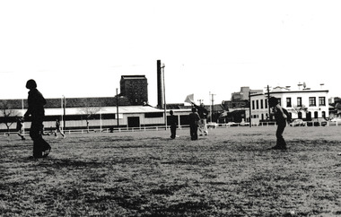
 Kew Historical Society Inc
Photograph - Construction of the Eastern Freeway (F19), Ron Setford, March 1972
Ron Setford and his wife Grace Setford lived in Tanner Avenue, East Kew, from c.1946 to c.1995. A keen photographer, he recorded the changing face of Kew over a 20 year period. Apart from 30 photographs of built structures and places in Kew dating from 1960 and 1961, 145 of his 35mm colour slides chronicle the development of the F19 (later renamed Eastern) Freeway through the Yarra Valley in Kew over a five year period from c.1972 to c.1977. This important collection was donated to the Society by his granddaughter in 2025.This collection of 175 35mm slides is of local and statewide significance, owing to its subject matter, particularly the major development of road transport infrastructure during the 1970s with the construction of the Eastern Freeway. The photographer also took care to annotate and date most of his slides which enable the researcher to pinpoint temporal and spatial locations.Photograph of works involved in construction of the F19 (now Eastern) Freeway. The photo shows how construction sometimes took account of key environmental features; in this case the Kew Billabong."Eastern Freeway / "The Lagoon" to be saved at all costs"ron setford, eastern freeway, f19 freeway, kew billabong -
Federation University Historical Collection
Book, Department of External Affairs, Melbourne, Bulletin of the Northern Territory, Bulletin No. 1, March 1912, 1912
Soft brown covered book of 68 pages. Photographic images of Roper River, Mount McMinn, Abraham's Lagoon, Edith Creek, Red Lily Lagoon, Darwin Boy Scouts, China Town in Darwin, Umbrawarra Creek, Paddy's lagoon, McMinn's Homestead, gold cradle, Aborigines, Syphilis, Mungurai, yaws.northern territory, scientific expedition, health, domesticated animals, j.a. gilruth, a. breinl, mosquitos, paul foelscher, roper river, mount mcminn, abraham's lagoon, edith creek, red lily lagoon, darwin boy scouts, china town in darwin, umbrawarra creek, paddy's lagoon, mcminn's homestead, gold cradle, aborigines, syphilis, mungurai, yaws, buffalo fly, henry tryon -
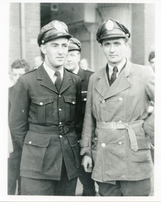 Victoria Police Museum
Photograph (police drivers)
Bill Lagoon (l) and Pat Ryan (r). Circa 1955police drivers; wireless patrol; motor transport branch; lagoon, william james; ryan, patrick -
Port Melbourne Historical & Preservation Society
Plan - Lagoon outlet, Sandridge, 13 Nov 1861
Plan of outlet of lagoon showing proposed new channel, 1861.Signed by Fredk. Wm. Ball, Municipal Surveyor, Sandridge.sandridge lagoon -
Port Melbourne Historical & Preservation Society
Plan - Proposed improvements, Foreshore, east of Lagoon Dock, Port Melbourne, Engineering Department, City of Port Melbourne, 25 Mar 1919
1919 plan - proposed foreshore improvement east of the Lagoon Dock.A.V. Heath (Town Surveyor):R. H. Gill (Mayor)built environment - recreational facilities, arthur victor heath, town clerks, richard henry gill, mayors -
 Port Melbourne Historical & Preservation Society
Photograph - Lagoon Reserve Port Melbourne, Reverend Donald LANGFORD, 19 Aug 1975
Port Melbourne cub scouts watch as a kite is flown. In the middle background is the Starch Factory and on the right the Graham Hotel.B & W photograph of Lagoon Reserve with Cubs kite flyingJune 1973built environment - industrial, business and traders - hotels, harpers starch factory, built environment - recreational facilities, lagoon reserve -
Port Melbourne Historical & Preservation Society
Plan - Proposed footbridge over the Lagoon, Bridge Street, Port Melbourne, 1863
Plan of proposed footbridge over the Lagoon in line of Bridge StreetIn ink on reverse, two small drawings: elevation land view over a distance of 25.00 chains (colour tinted), and Plan view, section of an unidentified street:In pencil on reverse, notation '107 Albert Street'sandridge lagoon, robert h morgan -
 Kew Historical Society Inc
Photograph, Floods in North Kew, 1934
Living with natural processes was frequently a challenge to early European settlers and later residents of what was in the 1850s administered by the Borondara Road Board. This was compounded by the area being bounded on three sides by rivers (Yarra River, Koonung Creek and Gardiner's Creek). In 1849, the historian James Bonwick recorded that "our district [Kew] suffered considerably. Mr Wade speaks of 80 acres, out of 100 acres of his cultivated paddock, covered by water." Newspapers continued to describe major flooding in Kew in 1863, 1869, 1878, 1880, 1889, 1891, 1916 and 1934. While the construction of the Upper Yarra dam in 1957 reduced the levels of flowing downstream, local and riverine floods continue.The Kew Historical Society's pictures and map collections testify to the impact of flooding in the district. They have historical importance in documenting the extent of flooding in the district and its affects on homes, services and recreation. Numerous photographs record flooding throughout the Twentieth Century.Floods in North Kew, 1934. Flood near the lagoon (Billabong?)floods (kew) 1934, yarra river -
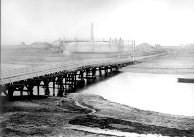 Port Melbourne Historical & Preservation Society
Photograph - Graham Street footbridge over the Lagoon, Sandridge, Charles Nettleton, 1870s
Sepia photograph of Graham Street footbridge over the Lagoon in 1870s, showing Gasworks across Lagoon - taken from a badly damaged Nettleton original (#187) in our collection and digitally retouchedsandridge lagoon, gasworks, built environment - industrial, natural environment, engineering - bridges, charles nettleton -
 Orbost & District Historical Society
black and white photograph, February 1971
This photograph is an aerial view of the township of Orbost taken by the Bairnsdale Advertiser newspaper. It was taken from the northern end of the town. The 1971 flood was the the worst flood on record. At Jarrahmond it was at least 11 metres and up to one and a half kilometres wide on the flats causing enormous damage to the flood plain. Records say that "The brown floodwater stain in Bass Strait could be seen from passing airliners." Considerable damage was done to railway infrastructure, roads and farms. More information from the APRIL, 2008 newsletter by John Phillips. (see orbosthistory.com.au)This is a pictorial record of a significant event in the history of Orbost,A black / white aerial photograph of a township with floodwaters in the background.on back - "Note main current through the lagoon 1971."orbost-floods-1971 bairnsdale-advertiser orbost-township -
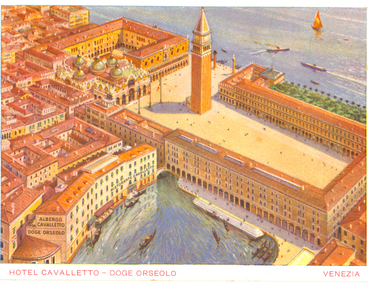 Federation University Historical Collection
Photograph - Colour, Hotel Cavalletto - Doge Orseolo, Venezia, c1920
Colour postcard showing a number of Venetian buildings surrounded by water.chatham-holmes family collection, venice, lagoon -
Glenelg Shire Council Cultural Collection
Photograph - Photograph - Fawthrop Lagoon, n.d
Port of Portland Authority Archivesport of portland archives, fawthrop lagoon -
Glenelg Shire Council Cultural Collection
Photograph - Photograph - Fawthrop Lagoon, n.d
Port of Portland Authority Archivesport of portland archives, fawthrop lagoon -
Port Melbourne Historical & Preservation Society
Photograph - Peter STRYAKIS at Lagoon Reserve, Janet Bolitho, 2006
Colour photograph Peter STRYAKIS and his dog "Olympia" at Lagoon Reservelagoon reserve, celebrations fetes and exhibitions, built environment - recreational facilities, peter stryakis, olympia -
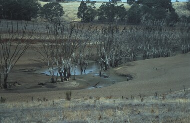 Bendigo Historical Society Inc.
Slide - VAL DENSWORTH COLLECTION: DRY LAKE EPPALOCK, May 2004
Slide. Dry Lake Eppalock. Lagoon in the river surrounded by dead trees.slide, bendigo, dry lake eppalock., dry lake eppalock. -
University of Melbourne, Burnley Campus Archives
Photograph - Black and white print, 4/19, 1943
View of Lagoon Padddock with Swan Street Bridge in the background. March 1943.lagoon padddock, swan street bridge, e. m. gibson collection