Showing 10911 items
matching lander
-
 Melbourne Legacy
Leisure object - Toy Bear, Legacy Bear $20 - Female Land Army Bear, 2022
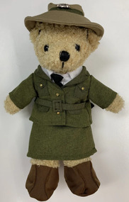
In the 2000s Legacy released a range of Legacy Bears to expand the merchandise available for sale during Legacy Week and at other fundraising opportunities during the year. This special edition WW2 land army bear was released in 2019. The Women's Land Army (WLA) was a British civilian group created during World War II to replace the men called up for the military. Over 80,000 women served working on farms, in sawmills, and in forestry. They became know as Land Girls and Lumber Jills. Please note the archive does not have a copy of this bear but is recorded here to complete the series.An example of the type of products sold along with Legacy Badges for fundraising in the 2010-2020s.Legacy bear dressed in a female WW2 Land Army uniform with a printed cardboard tag.Printed tag gives the price as $20.legacy appeal, fundraising, legacy bear -
 Greensborough Historical Society
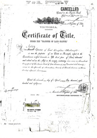
Document - Certificate of Title, Mayger land, 1863o
Land originally granted to John Alison 09/09/1840. 1. Certificate of Title: Edwin Willis Mayger 14/08/1863: Vol. 5 Fol. 860. 2. Transfer document: 2 mortgages for Edwin Willis Mayger; Transfer from Mayger to Charles Partington. Shows part of the chain of ownership of this parcel of land in Greensborough.2 pages. Copies of land titles and associated documentsland titles - greensborough, mayger family, partington family, maygar family -
 Whitehorse Historical Society Inc.
Document, Memorials, 1871 & 1970
Memorial of transfer of land from William Kennard, William Coe & Francis Turner to the Board of Education, 1871 and from L.H.S Thompson, Minister for Education and Board of Education to City of Nunawading 2 June 1970.Memorial of transfer of land from William Kennard, William Coe & Francis Turner to the Board of Education, 1871 and from L.H.S Thompson, Minister for Education and Board of Education to City of Nunawading 2 June 1970. This land became the site of Vermont State School No. 1022.Memorial of transfer of land from William Kennard, William Coe & Francis Turner to the Board of Education, 1871 and from L.H.S Thompson, Minister for Education and Board of Education to City of Nunawading 2 June 1970.victoria, board of education, vermont state school, no, 1022, kennard, william, coe, william, turner, francis, city of nunawading -
 Ballarat and District Irish Association
Image, Land League Committee Meeting, Dublin, 1864
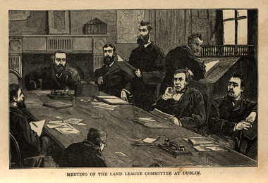
The Irish National Land League (Irish: Conradh na Talún) was an Irish political organisation of the late 19th century which sought to help poor tenant farmers. Its primary aim was to abolish landlordism in Ireland and enable tenant farmers to own the land they worked on. The period of the Land League's agitation is known as the Land War. Within decades of the league's foundation, through the efforts of William O'Brien and George Wyndham (a descendant of Lord Edward FitzGerald), the 1902 Land Conference produced the Land (Purchase) Act 1903 which allowed Irish tenant farmers buy out their freeholds with UK government loans over 68 years through the Land Commission (an arrangement that has never been possible in Britain itself). For agricultural labourers, D.D. Sheehan and the Irish Land and Labour Association secured their demands from the Liberal government elected in 1905 to pass the Labourers (Ireland) Act 1906, and the Labourers (Ireland) Act 1911, which paid County Councils to build over 40,000 new rural cottages, each on an acre of land. By 1914, 75% of occupiers were buying out their landlords, mostly under the two Acts. In all, under the pre-UK Land Acts over 316,000 tenants purchased their holdings amounting to 15 million acres (61,000 km2) out of a total of 20 million acres (81,000 km2) in the country. Sometimes the holdings were described as "uneconomic", but the overall sense of social justice was undeniable. (http://en.wikipedia.org/wiki/Irish_National_Land_League, accessed 21 January 2014) The Irish National Land League was founded at the Imperial Hotel in Castlebar, the County town of Mayo, on 21 October 1879. At that meeting Charles Stewart Parnell was elected president of the league. Andrew Kettle, Michael Davitt, and Thomas Brennan were appointed as honorary secretaries. This united practically all the different strands of land agitation and tenant rights movements under a single organisation. The two aims of the Land League, as stated in the resolutions adopted in the meeting, were: ...first, to bring out a reduction of rack-rents; second, to facilitate the obtaining of the ownership of the soil by the occupiers. That the object of the League can be best attained by promoting organisation among the tenant-farmers; by defending those who may be threatened with eviction for refusing to pay unjust rents; by facilitating the working of the Bright clauses of the Irish Land Act during the winter; and by obtaining such reforms in the laws relating to land as will enable every tenant to become owner of his holding by paying a fair rent for a limited number of years. Charles Stewart Parnell, John Dillon, Michael Davitt, and others including Cal Lynn then went to America to raise funds for the League with spectacular results. Branches were also set up in Scotland, where the Crofters Party imitated the League and secured a reforming Act in 1886. The government had introduced the first ineffective Land Act in 1870, then the equally inadequate Acts of 1880 and 1881 followed. These established a Land Commission that started to reduce some rents. Parnell together with all of his party lieutenants, including Father Eugene Sheehy known as "the Land League priest", went into a bitter verbal offensive and were imprisoned in October 1881 under the Irish Coercion Act in Kilmainham Jail for "sabotaging the Land Act", from where the No-Rent Manifesto was issued, calling for a national tenant farmer rent strike which was partially followed. Although the League discouraged violence, agrarian crimes increased widely. Typically a rent strike would be followed by evictions by the police, or those tenants paying rent would be subject to a local boycott by League members. Where cases went to court, witnesses would change their stories, resulting in an unworkable legal system. This in turn led on to stronger criminal laws being passed that were described by the League as "Coercion Acts". The bitterness that developed helped Parnell later in his Home Rule campaign. Davitt's views were much more extreme, seeking to nationalise all land, as seen in his famous slogan: "The land of Ireland for the people of Ireland". Parnell aimed to harness the emotive element, but he and his party preferred for tenant farmers to become freeholders on the land they rented, instead of land being vested in "the people".(http://en.wikipedia.org/wiki/Irish_National_Land_League, accessed 21 January 2014)Image of a number of men sitting around a table. They are members of the Land League Committee during a meeting in Dublin.ballarat irish, land league, land league committee, dublin -
 Greensborough Historical Society
Folder of Documents, Greensborough Park: Land Title Histories and Associated Instruments, 1872-1976
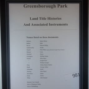
Land title documents trace the ownership of what is now known as Greensborough Park from 1872 to 1976.This property was owned at various times by well known Greensborough identities. The documents show the change from private ownership to public ownership of the site.Folder of copies of land title documents. 20 pages. Includes CD of electronic copies.greensborough park, banyule city council, shire of heidelberg, shire of diamond valley -
 St Kilda Historical Society
Document, Plan of Town of Melbourne 1837 AD, 1837 (original)
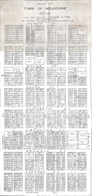
Shows the outcome of the first land sales held in Melbourne, on 1 June and 1 November 1837. All the names and prices for each lot are displayed.Photocopy of "Plan of Town of Melbourne 1837 A.D." showing first land sales.All lots printed with name of buyer and price paid.melbourne - history, town of melbourne- 1837, 19th century -
Whitehorse Historical Society Inc.
Article, Crops yield to city sprawl, 19/05/1999 12:00:00 AM
History of the Fulton family and its life in Burwood as market gardeners.History of the Fulton family and its life in Burwood as market gardeners until the encroachment of the suburbs led to the sale of the land.History of the Fulton family and its life in Burwood as market gardeners.market gardeners, fulton, jim, fulton, mary, fulton, charles, fulton, ann, fulton, nell, fulton, olive, fulton, bill, old burwood road, burwood east, no 89 -
 Greensborough Historical Society
Folder, Montmorency and the Nicholson family, 2019_
This folder contains a brief history of the Nicholson family and material about Dr. George Cornwall Nicholson, purchaser of land in Montmorency formerly owned by the Donnithorne Family. Includes 9 Certificates of Title relating to the subject land and other certificates and listings relating to their residency of "Glengarriff" and activities. It records an active professional Montmorency resident and community member, and the later subdivisions of the Glengarriff EstateLoose-leaf folder containing a brief history of the Nicholson family and Dr. George Cornwall Nicholson, purchaser of land in Montmorency. Includes 9 Certificates of Title relating to the subject land and other certificates and listings relating to their residency of "Glengarriff" and activities.glengarriff estate montmorency, nicholson family, donnithorne family -
 Rutherglen Historical Society
Image, Indigo Shire Council, 28/10/2009
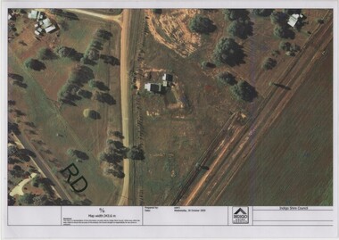
When operational, the Gold Battery used cyanide in its processing processes. The land surrounding it required remediation before it could be handed over to Indigo Shire for public use. The land has since been planted with pasture and native plants. The Gold Battery has been restored to working condition, and can be viewed by collecting a ticket from the Rutherglen Wine Experience and Visitor Information Centre.Laminated aerial photograph of Gold Battery site, believed taken before land remediation.gold battery, gold processing -
Clunes Museum
Book, LANDCARE MANAGEMENT, 1998
ULLINA LAND CARE GROUP LANDCARE MANAGEMENT PLAN. FUNDED BY NATIONALLAND CARE PLAN. AUGUST 1998. PRINCIPAL CONSULTANT THOMSON HAY & ASSOCIATES PTY LTD.SPRING METAL BOUND BOOK - ULLINA LANDCARE GROUP LAND AND MANAGEMENT PLAN.local history, book, reference, landcare -
 Kew Historical Society Inc
Plan, Survey Plan, Park Hill Road, Kew, 1880-1890
The streets identified on the survey plan - Cotham Road, Park Hill Road East, Park Hill Road West in Kew were each gazetted by the Victorian Government in 1865. The hand-coloured survey plan was completed by Holland Loxton, Town Clerk and Surveyor of the Borough of Kew from 1866. The unnamed survey plan includes names of land owners in addition to measurements (2 chains to 1 inch) and streets. Named owners include Webster, Payne and Francom which will enable us to narrow down the creation date of the survey.Handdrawn survey plan by a former surveyor and town clerk of KewHand drawn and coloured survey plan created by Holland Loxton, Surveyor and Town Clerk of Kew, showing land owned by Payne in Park Hill Road, Kew. The plan includes street names, land measurements and land owners.surveys - kew, maps - kew, holland loxton, park hill road - kew, holland loxton -- surveyor, survey plans -- parkhill road -- kew (vic.) -
 Otway Districts Historical Society
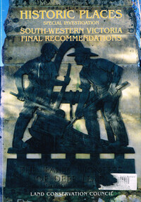
Book, Land Conservation Council, Historic places: special investigation: South-Western Victoria: Final recommendations, January 1997
The Land Conservation Council has carried out an investigation of historic places in public land in South-western Victoria. The report contains the Council's recommendations for the protection, management and future use of more than 700 historic places, out of 2200 places identified during the investigation. The places have been assigned to three categories, A, B and C, representing State, regional and local levels of significance. The report also contains recommendations relating to general historic places management, the processes available in Victoria for the protection of historic places on public land, and Aboriginal historic places.Historic places: Special investigation: South-Western Victoria: Final recommendations. Land Conservation Council. Land Conservation Council; Melbourne (Vic); January 1997. viii, 176 p.; illus.; maps. Soft cover. ISBN 0 7241 9290 5Maps in plastic sleeve.land conservation council; conservation; historic places; public land; aborigines; south west victoria; -
 Ringwood and District Historical Society
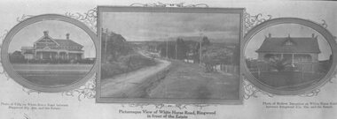
Photograph, Strip of images used for Ringwood Heights Estate land sale promotion - 1924
Strip of 3 views apparently part of a land sale advertisement - View of Whitehorse Rd between photos of two Whitehorse Rd houses.Typed on back of photographs, "Ringwood Heights Estate. Land on left of road and down to Mullum Creek. Sold by T. Grant. 97 lots, 1st March 1924. J.B. McAlpin, agent. No deposit, 1 pound per month." -
 Ringwood and District Historical Society
Newspaper, Scrapbook Clipping, Library Collection, Ringwood, Victoria
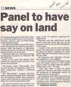
Newspaper Clipping from "The Mail", 3-10-95. P23. By Andrew Meath. Panel to have Say on LandAn independent panel will decide whether a housing subdivision in an environmentally sensitive part of North Ringwood should proceed. The Ministry of Planning and Development will appoint the panel to consider a request from developers of Barnsdale Forest to divide one acre (0.4 hectares) parcels of land into 7 lots -
Whitehorse Historical Society Inc.
Map, Map of Vermont area, c1895
Photocopy of part of a larger map showing the Vermont area.Photocopy of part of a larger map showing the Vermont area. Note on side 'after 1892'. Shows land holders.Photocopy of part of a larger map showing the Vermont area.maps, vermont -
Whitehorse Historical Society Inc.
Book, Sevenoaks Park, 1980 repr. 2004
A history of Jeffery Street Blackburn and surrounding area once known as Sevenoaks Park.A history of Jeffery Street Blackburn and surrounding area once known as Sevenoaks Park. Contains old maps and land titlesA history of Jeffery Street Blackburn and surrounding area once known as Sevenoaks Park. sevenoaks park, jeffery, mary ann, jeffery street blackburn, blackburn road blackburn, lake road blackburn, da costa, robin, burns, frank, satchwell, keith -
Whitehorse Historical Society Inc.
Document, Certificates of Title - Arthur Royle & Robert Driver Thurgood, 1931, 1934
Certificate and TitleCertificate and Title for house and land off L.L. Vale Road, Vermont and correspondence re outstanding rates.Certificate and Title shire of blackburn and mitcham, rates, land titles, royle, arthur, thurgood, robert driver, boronia road, vermont -
 Bendigo Military Museum
Equipment - MUG, post 1960
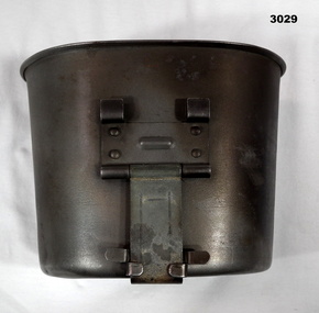
The Army terminology for this item is, “Cups canteen steel”Mug, stainless steel, kidney shaped with metal foldout handle.“US Landers ..........”military history - equipment, mug, cup, equipment -
 Ringwood and District Historical Society
Letter, JK McCaskill objecting to the Bowling Club using further public reserve land
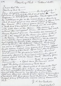
1929 saw the establishment of the Ringwood Bowls Club initially located on the land now occupied by the Eastland Shopping Centre. It moved to its current location in Loughnan Road, Ringwood in 1997.JK McCaskill objecting to the Bowling Club using further public reserve land. Undated.city of ringwood bowls club, ringwood bowling club, ringwood bowls club, lawn bowls, bowling -
 Greensborough Historical Society
Plan, Parish Plan Map of Land North of Grimshaw Street, 11/12/1879
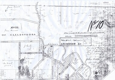
Part of Parish plan of land north of Grimshaw Street bounded by the Plenty River. Includes annotation signed by John Scotland and J. W. Britnell, dated Dec. 11th 1879.Photocopy of part of Parish plan of land north of Grimshaw Street bounded by the Plenty River. Includes annotation signed by John Scotland and J. W. Britnell, dated Dec. 11th 1879greensborough, grimshaw street greensborough, jonah britnell, john scotland -
 Greensborough Historical Society
Photograph, Keith Willimott, Willimott photographs, 1956-1964
8 photographs of construction of Willimott home, High Street Watsonia. Includes sale advert for land (The Age 1956)Photographs to accompany Willimott family oral history.Copy of group of black and white photographs. Copy of one newspaper advertisement for a block of land. 3 pages.Captions on back of each photograph.willimott family, watsonia, oral history -
Federation University Historical Collection
Document, License under Section 19 of "The Land Act 1869", 1875
Full license and authority to enter and occupy Crown Land outlined was given to James Cowan. This was for a period of three years and subjected to conditions outlined on the document. The area was in the County of Bourke, Parish of Blackwood. The area concerned is located on the Lerderderg River in the Wombat State Forest. The fee for occupation was to be paid in advance by half-yearly payments to the Land Officer at Ballarat. The document signed on 1 July 1875 by William F Stawell, Acting Governor of Victoria.Thick pale blue paper. Hand written in ink Hand drawn map of land in questionDated 1 July 1875 Signed William F Stawelllicence, license, crown land, james cowan, county of bourke, parish of blackwood, lerderberg river, wombat state forest, william foster stawell, acting governor, land officer, ballarat -
 Otway Districts Historical Society
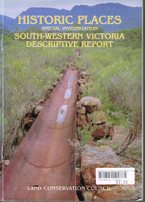
Book, Land Conservation Council, Historic places: Special investigation: South-Western Victoria: Descriptive report, January 1996
The south-west of Victoria, possessing a rich heritage of the signs of past human activity, is fertile ground for an investigation of historic places on public land. This report includes an initial inventory of almost 2000 places. The report outlines the history and the related heritage of the area, describes in some detail its biophysical attributes and introduces the natural resources and present land use. This information provides a context for understanding the origins of the historical features that are observes today.Historic places: Special investigation: South-Western Victoria: Descriptive report. Land Conservation Council. Land Conservation Council; Melbourne (Vic); January 1966. viii, 180 p.; illus.; maps. Soft cover. ISBN 0 7241 9288 3Maps in plastic sleeve.land conservation council; conservation; south-western victoria; historic places; -
 Greensborough Historical Society
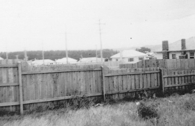
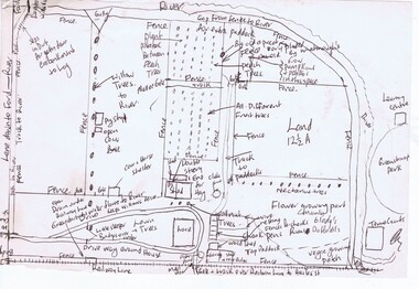
Map, Gary Partington, Alwyn at Whatmough Park, 1960s
The property "Alwyn" was owned by the Partington family and was compulsorily acquired by the Shire of Diamond Valley to become Whatmough Park. This plan was drawn from memory by Gary Partington and illustrates land use when his father, Alan Partington, owned the property.This plan illustrates the rural nature of land around Greensborough prior to the 1960s.Drawing of land use in 1960s at "Alwyn", a property currently occupied by Whatmough Park alwyn, partington family, whatmough park -
Whitehorse Historical Society Inc.
Letter - Correspondence, St Edward's Church of England, 1/03/1963 12:00:00 AM
Letter forwarded with cheque from W.B. Wicking to St Edward's Church of England, Blackburn SouthLetter forwarded with cheque from W.B. Wicking to St Edward's Church of England, Blackburn South as a loan to purchase 2 blocks of land.Letter forwarded with cheque from W.B. Wicking to St Edward's Church of England, Blackburn Southst edward's anglican church, blackburn south, wicking, walter benjamin -
Ringwood and District Historical Society
Report, McAlpin, J.B, Report and valuation of land in Ringwood 1931, 23-Nov-31
Report and valuation of land in Ringwood in the name of David Bull EsqSingle page hand written report - valuation of land in Ringwood with area map. +Additional Keywords: McAlpin, J.B. / Bull, David -
 National Wool Museum
Newspaper, Stock and Land
"Stock and Land" newspaper, Wednesday 10th October, 1951, addressed to Mr HL Cameron, Box 26, Warnambool."Stock and Land" newspaper, Wednesday 10th October, 1951, addressed to Mr HL Cameron, Box 26, Warnambool.agriculture - news, stock and land, woods, mr george -
Whitehorse Historical Society Inc.
Article, School Site Too Costly
Whitehorse Council has rejected an offer to buy the former Nunawading Primary School site.Whitehorse Council has rejected an offer to buy the former Nunawading Primary School site but will continue to lobby the State Government to preserve the land.Whitehorse Council has rejected an offer to buy the former Nunawading Primary School site. city of whitehorse, nunawading primary school no.4190, springvale road, nunawading no.96 - 106 -
 Greensborough Historical Society
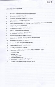
Folder, Peter Simmenauer, Partington land, edited by Peter Simmenauer, 1850-1950
Folder of documents relates to ownership of Crown Portion 13, Parish of Nillimbuk, County of Evelyn, purchased by John Alison in 1840 and sold to various people including Charles Partington Snr in 1878. It includes Certificates of Title recording transfers to Charles' children, and details of the land retained by Charles Jnr and Joseph Partington until their deaths in 1932 and 1943 respectively. A list of sales of allotments in the "Greenhills Estate" is also included.Folder of documents including Certificates of Title and other land documentsjohn alison, charles partington, charles partington junior, joseph partington, greenhills, partington family, greensborough, willis vale -
 City of Moorabbin Historical Society (Operating the Box Cottage Museum)
Document - Photocopy of Land Title 1881, c1881
This is a Certificate of Title for an acre of land in 'Tucker's Road' purchased by Jabez Gurr in 1881, in the area that was part of the Crown Block known as Henry Dendy's Special Survey 1841, in the Parish of Moorabbin, County of Bourke, Victoria. Following the 'Transfer of Land Statute' allotments in the area of Henry Dendy's Special Survey of 1841 were sold to early settlers. This Certificate of Title shows the passage of history in Moorabbin Shire . Jabez Gurr, a wheelwright, of East Brighton, now Bentleigh East, purchased an acre of land in 'Tucker's Road' , near Centre Road, in 1881. In 1889 he sold to a produce merchant, Robert Smith, and in April 1916 this block was purchased by William Henry George Box, a market gardener and relative of William and Elizabeth Box, who owned the land until 1926. The land was then purchased by Charles John Greenlaw Coates and remained with this family until 1971. All these Family names appear on Councils and Community Boards during the foundation and development of City of Moorabbin3 photocopied pages of the Certificate of Title for approximately 1 acre of land near the corner of Centre Road and Tucker Road, Parish of Moorabbin, County of Bourke, Victoria that was part of the 5,120 acre Henry Dendy Special Survey in Brighton in 1841 and purchased in 1881 by Jabez Gurr. It records subsequent proprietors up to 1971Stamped CANCELLED 12 OCT 1994 (top Right) / Entered in the Register Book / Vol.1245 Fol. 248877/ signed Henry Crowe / Assistant Registrar of Titles / Coat of Arms / VICTORIA / Certificate of Title / UNDER THE ' TRANSFER OF AND STATUTE' /dated ' eleventh day of April one thousand eight / hundred and eighty one' / signed 'Henry Crowe' / Assistant Registrar of Titles/ ENCUMBRANCES REFERRED TO / circular Stamp 'OFFICE OF TITLES VICTORIA' / Drawn and shaded on the left side is the area of land in "Tucker's" Road 3331/3 links fro Centre Road, 150 links x 6662/3 links / The measurements are in linksdendy henry, dendy's special survey 1841, brighton, moorabbin, bentleigh, market gardeners, early settlers, pioneers, wheelwrights, merchants, fruit gardens, markets, smith robert, box william henry george, gurr jabez, county of bourke, victoria, melbourne, land statutes, tucker road, centre road, box william, box elizabeth, box cottage museum