Showing 165 items
matching local trees - and others
-
 Ballarat Tramway Museum
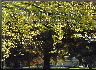
Book, Friends of the Botanical Gardens, "An Eden of Loveliness - Ballarat Botanical Gardens", 2012
Book - 6 sections, sewn hard cover with glued face sheets, 122 pages, full colour printing, art paper with table of contents, index, sources and maps, titled "An Eden of Leveliness - Ballarat Botanical Gardens". Provides a detailed illustrated history of the Ballarat Botanical Gardens. Looks at the creation of the gardens, the north and south foreshores, Lake Wendouree, Friends of the Botanical Gardens, Begonias, the Heritage trees and provides a timeline of development. Has some notes on the Ballarat Tramway Museum, fish hatchery and other features of the area. Published by the Friends of the Ballarat Botanical Gardens, 2012.On inside of the front cover "To the Ballarat Tramway Museum, Enjoy, from the Friends of the Botanical Gardens June 2016"trams, tramways, lake wendouree, botanical gardens, btm, gardens, begonia festival, local history -
 Ballarat Tramway Museum
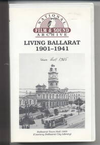
Film - Video cassette tape and box, Chris Long, "Living Ballarat 1901 - 1941", 1990
Yields information through movie films of the 1960's of Ballarat trams operating in the streets of Ballarat and has a strong association with the maker - National Film and Sound Archives and Chris Long.Video cassette in a plastic case, titled "Living Ballarat - 1901 - 1941, National Film and Sound Archive (1990)". See Reg item 4519 for the DVD version. The DVD was made by Peter Winspur using this tape. Transferred to the Hard Drive 11/1/2010- AV Files - dB text/AV Files/Reg Item 4519/Video_TS (at 12/1/2010) Copyright provisions - National Film and Sound Archive - segments may not be used without their permission, viewing only. Synopsis: based on time - 0.00 - intro, 1901 film, Melbourne, first film in Ballarat, Royal visit to Ballarat, Boer War Monument, first feature length film in Ballarat. 2.50 - Bridge St and Sturt St scenes, filmed from a flat truck pushed by an electric tram, including No. 11 going to City Oval to Lydiard St. 5.00 - Sturt St Military parade, with trams in background and tram running alongside. 6.54 - scene of Alfred Hall and films. 7.32 - scene on Lake Wendouree and paddle steamer - Living Ballarat film - Pathe's Ballarat Gazette local film unit, football ground scene. a children's beauty competition, tree planting at Macarthur St state school, 1911 Ballarat Show, unveiling of the Boer War statue name plates, Lake Wendouree 1912. 13.22 - St Patricks David Pde with trams in the background. 14.24 - Ballarat Kennel club dog show. 15.50 - Royal visit in 1920, Arch of victory opening 17.48 - Day at Macarthur St state school and tree plantation 20.55 - Bakery Hill - Stones Corner with tram tracks, cars, little trams, Sturt St with a tram leaving Grenville St, ESCo 9 turning from Lydiard St to run down to Grenville St. 22.15 - Ballarat Show, Coliseum Hall, 1925, races, machinery shows, boxing troupe. 25.20 - Botanic Gardens Gates, Lake Wendouree area. 25.30 - Gem Picture travelling show - film 26.16 - Formal visit of English pressman to Ballarat, 1925, Botanic Gardens, Eureka Stockade, Avenue of Honor, Moorabool Reservoir. 29.15 - 1927 Fed Govt doco of Ballarat, Black Hill, 1927 Home to Ballarat Festival, Ballarat Commemorative song, Craigs Hotel, Ballarat Post Office, tram centre poles in Lydiard St, tram climbing Sturt St, Town Hall, tram at Lydiard St terminus coursing, 8, Sturt St, view of ESCo Sebastopol car leaving Grenville St, Selkirks Brickworks, the Welcome nugget, Peter Lalor statue, Eureka stockade, sewerage plant, modern housing, Sturt St west, water supply - golf club, the High School, the orphanage, fine homesteads around Ballarat, Lake Wendouree. 41.00 Opening of the Ballarat Aerodrome. 43.11 - Depression work and leading into radio broadcasting - 3BA open 1930, typewriters, radio transmission equipment, radio aerials, boys listening to crystal sets 47.50 - Bluebirds Children session tour to the Gardens, mentions the BTPS, trams 13, 3? and 14 carrying visitors arriving and getting off and picnic. 48.50 - expansion of 3BA transmitter capacity 51.30 - 1934 visit of the Duke of Gloucester - visit to the Lucas factory, views of the work floor and the factory history and then South St band competition at the Showgrounds. 55.10 - South St Music Festivals, Coliseum and fire. 56.25 - Ballarat Floral Festival March 1938 - Victorian Railways arch of welcome. 57.25 - segment in the shot of 12 and 19? in Sturt St 57.45 - colour segment of the festival, 58.39 - Grenville St tram shelter, Bridge St, Sturt St, arches, Main Road, Council Road Roller, Victoria St, Eureka Stockade Reserve, Botanic Gardens, setting up the flowers, wax papers. 1.01.48 - decorated tram, north side of Sturt St, details of the materials used, Crockers. 1.03.20 - Hospital Fund Raising Gala Day - March 1938, special trains arriving Ballarat Railway Station, fund raising procession, pageant at the Showgrounds, fly past. 1.07.35 - 1939 Summer, motor cycle races at Learmonth, City Oval fire brigade demonstrations, Ballarat (East) Fire Station decorated for the 1939 Floral Festival with tram in the background and No. 29, Floral Tram and others. 1.09.25 - July 1914 - Ballarat at War parade, troops. 1.10.10 - credits. Box has images of a tram and town hall on the front and details of the contents on the rear and who made it etc. See images for details. ballarat, 3ba, floral tram, royal visit, buildings, esco -
 Bendigo Historical Society Inc.
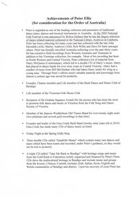
Document - PETER ELLIS COLLECTION: ORDER OF AUSTRALIA
4 page A4 printed document. Achievements of Peter Ellis (for consideration for the Order of Australia) Peter is regarded as one of the leading collectors and presenters of traditional dance tunes, dances and musical instruments in Australia. At the 2005 National Folk Festival it was announced by Robyn Holmes that he has the largest selection of dance related material collected in the National Library Archives in Canberra. Peter has been collecting for many years and has collected with the late John Meredith (AM), Shirley Andrews (AM), Rob Willis and Dave Di Santi amongst others. Peter has literally travelled Australia collecting over the past thirty years. He has extensive field recordings from Western Australia and Tasmania in addition to his Victorian collection, for example. Most of his recording has been in North Western and Central Victoria. Peter collected a lot of his material from Harry McQueen ( Castlemaine), which led to a double CD of Harry's music. Harry had played in dance bands for over sixty years in Central Victoria. Harry had a number of tunes from Bill McGlashan who had taken Harry under his wing as a young man. Through Peter's efforts much valuable material and knowledge from almost a century ago was saved for posterity. Founder, Charter member and life member of the Bush Dance and Music Club of Bendigo. Life Member of the Victorian Folk Music Club. Recipient of the Graham Squance award (for the person who has done the most to promote folk dance and music in Victoria)) from the Folk Song and Dance Society of Victoria. Member of the famous Wedderburn Old Timers Band for over twenty-eight years (two platinum and several gold recordings in that time). Founder and leader of the Emu Creek Bush Band (twenty-nine years old in 2010) Emu Creek has made many CDs of dance music as listed. Friday Night at the Spring Gully Hop, Three double CDs called 'Quadrille Mania' which contain many rare dances and tunes which have been learnt and recorded, under Peter's guidance, so they would not be lost to posterity. A triple CD called 'Take Me Back To Bendigo' with heritage songs and music from the Gold Rush to Federation (solely organised and financed by Peter) These CDs show the multicultural heritage in Bendigo and include music and groups from the Koorie, Chinese, Cornish, German, Irish, Italian, Scots, English and Welsh communities of Bendigo and district. Upon his recovery of costs Peter has handed over copyright to the Bendigo Community so future profits go back into the community. Three double CDs called 'The Merry Country Dance' with dances and tunes going back to the time of Governor Lachlan Macquarie's Ball in 1804. Most of the tracks are performed by Emu Creek Following much practice under Peter's tutelage. For further authenticity Peter liaised with other musicians to record some tracks which were revived from almost two hundred years ago and have now been recorded using the instruments of the time. A three volume set of Bush Concert recordings (Vol 1 Goornong (launched Australia Day 2006 with any profits going to the Soldier's Memorial Hall Committee), Vol 2 Heywood and Vol 3 Maldon/Sutton Grange, already recorded and to be released as money from other projects becomes available. NOTE: None of these CDs have led to any profit. All money raised is put back into the community and further heritage recordings, books and videos through the Bush Dance and Music Club of Bendigo Inc. In 2009 a full collection of all Peter's book and CDs was donated to the John Gorton Library as part of the recognition of the fifty year career of the Gay Charmers Dance Band from Lake Charm. 'Music of the Diggings' (4 tracks by Peter or Emu Creek). In addition the Emu Creek Band, under Peter's leadership, has appeared on a CD backing Bruce Watson on his song, 'The Old Bush Dance'. Emu Creek has performed at National Folk Festivals in four states and several times at the National Folk Festival in Canberra. They have also been mainstays of the Maldon Folk Festival for over twenty years as well as doing dance programs for the Port Fairy Folk Festival on two occasions. Peter has written and published many books related to traditional music and dance. These include Three volumes of 'Collectors Choice' which is musical notation for bush dances coupled with much dance history which would have been lost without Peter's efforts. 'Two Hundred Dancing Years - How to run a Colonial Ball: (co-authored with Shirley Andrews (A.M.), 'Music Makes Me Smile - The Music of the Nariel Valley' (co-authored with Harry Gardner). The Merry Country Dance' (292 pages) a companion to the three double CDs. He has also been a contributor to Verandah Music' authors Rob Willis and Graham Seal and 'The Oxford Companion to Australia Folklore' Ed Graham Seal. Peter is also a regular contributor to 'Trad and Now' Magazine. His latest completed book is titled 'The Merry Country Dance' and is over three hundred pages of social history, recipes and dance instructions. It was completed with the assistance of a Victorian Government Heritage Grant. The first edition sold out in only a few weeks. Peter has taught many children about old time musicianship through the junior bands which have functioned over the years with many children joining Emu Creek and then going on to follow their own musical inclinations. He has trained several young concertina and button accordion players over the years. Peter has been a regular tutor with Continuing Education in tin whistle, harmonica and old time dancing for many years. Peter has conducted workshops in music dance at National Folk Festivals in Perth, Alice Springs, Maleny, Melbourne, Adelaide, Kuranda and more recently at several Canberra National folk Festivals. He has also done this at Maldon for many years, Port Fairy, Glen Innes, Jamberoo and Kiama Festivals. For over thirty years Peter has been a guest player and MC for the dances at the Nariel Folk Festival (Australia's oldest continuing Folk Festival) Peter is very well known in the Corryong area as a collector and the co-author of the book, Music Makes Me Smile, about the Klippel/Simpson dynasty in the Nariel Creek Band. This book is currently being revised for re-issue as more material has come to light since the original publication. For many years Peter trained Debutante Sets in the Bendigo District. Peter was an instigator of the annual Dinki Di Ball held each September in Eaglehawk for the past thirteen years. At this ball three bands play for a quarter of the night and then join together for the final part of the evening. The bands are Emu Creek, The Wedderburn Old Timers and the Gay Charmers. Up to four hundred dancers, many in heritage costumes have attended this dance. The ball also pays tribute to, and involves, the old MC's. Through this example their skills have been passed down to a younger generation of MC's. All profits are returned to the Dance Club to foster our musical heritage. Each Ball includes presentations designed to promote social dancing in Australia. Over the years several young musicians have been presented with musical instruments at the Ball, libraries have been given copies of Peter's books and CDs and one year a keen young dancer was presented a pair of dancing shoes. Peter is a trained ballroom dancer and has gained gold medal status in this field. Peter is an accomplished musician and is one of Australia's foremost button accordion players. He is also highly accomplished on the tin whistle, bones and harmonica. He is the only exponent of the Swanee whistle that I have seen. Peter also plays the piano and ukulele. Thirty six years membership of the Bendigo Field Naturalists Club, Secretary in the 1970s and actively involved in campaigns to save Lake Pedder and establish the Whipstick and Kamarooka State Parks (now part of the Bendigo National Park). Peter was also extremely active in the establishment of the Salomon's Gully and Jackass Flat Flora Reserves in Bendigo which have now been saved for posterity. Peter has also been involved in efforts to save One Tree Hill and this area has now been included in the Greater Bendigo National Park. He has discovered and named new plant species in the Whipstick Forest and propagates Australian plants. Peter takes regular guided tours of interested people through the Whipstick each Spring on wild flower educational tours. He is a keen and gifted photographer of local plant species. Life member of the Bendigo Field Naturalists. Peter contributed text and photographs to their publication 'Wildflowers of Bendigo'. When the Victorian State Parliament had its first historical sitting outside Melbourne Emu Creek played during lunch for the guests and public. They have also played at functions such as the Centenaries of Federation, the Bendigo Post Office, the Shamrock Hotel and the opening of the new Melbourne Museum and the Federation Museum in Bendigo. The band regularly plays for Seniors week and at homes for the aged such as Bethlehem, Mirridong, Bignold Park, Bendigo Village and others. Peter has been instrumental in getting the band to play for fundraisers such as schools, scouts and environmental groups. The band plays many charitable 'gigs'. The band supports the Bendigo Easter Fair and the Eaglehawk Fair when able and has appeared in several parades over the years. The above list shows the invaluable contribution that Peter Ellis has made towards the collecting and distributing of Australia's musical and dance heritage. No one has done more than Peter in this area. He has also been active locally and nationally in his endeavours towads saving the natural environment. He has put many years of time and energy into both area's and has many on going projects in mind for the years ahead. The awarding of an honour from Australia would be just reward for a man who has preserved so much of our musical and dance heritage for future generations. Knowing Peter I have no doubt he would treasure such an honour as he has given so much to preserve Australia's music and dance heritage over most of his sixty plus years. Compiled by John Williams. Handwritten notes at bottom of last page reads: Referees Jacinta Allan MLA Steve Gibbons MHR Willie Carney ex Mayor of Bendigo Supporting letter Mary Smith Sec. Bush Dance + Music Club.person, individual, peter ellis oam -
 Buninyong & District Historical Society
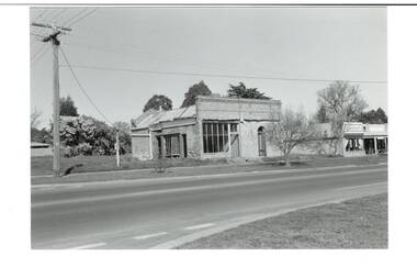
Photograph - Original B/W Photograph, Former Whyke's Grocer building, Warrenheip St, Buninyong, 18 September 1993
Original building was established by Whyke's family Grocery, built in 1860s. Stripped to apricot brickwork. Verandah removed. Situated East Side of Warrenheip St between Eyre St and Forest St, Buninyong. Building much altered and used as a restaurant in 1970s. Fell into disrepair. Revival took place but not restoration. 1990s under threat of demolition if not conforming to council safety requirements. Building has since been renovated as a pizza restaurant (2023). Vacant lots have since been built on.Established by a prominent local family, an example of a mid 19th century shop. Black and white photo of former Whykes Grocer, 1860's. Streetscape photo of former Whykes Grocer brick building. Power pole with Warrenheip St sign. 3 other shopfronts visible, street trees and vacant land between shops.buninyong, whykes, grocery, building, street scape, warrenheip st -
 Kew Historical Society Inc
Plaque, Kew City Hall : Opened by The Hon H.E. Bolte M.L.A. Premier of Victoria 23rd April 1960 : Cr H.H. Ferguson J.P. Mayor, 1960
The Municipality of Kew was proclaimed on 19 December 1860, then upgraded to a Borough (1863), a Town (1910) and finally a City (1921). From 1865, its offices were based in the former Athenaeum Hall in Walpole Street, which, although extended in 1883, inevitably became inadequate. Plans for a new purpose-built Town Hall were first mooted in the late 1880s, but fell prey to six subsequent decades of debate. During that time, many sites were considered and rejected, and several schemes prepared. Finally, in 1945, it was resolved to build a new civic centre as a war memorial. The council acquired Southesk, a mansion on the south-west corner of Cotham Road and Charles Street – first mooted as a possible Town Hall site two decades earlier – and plans for a civic precinct were drawn up by John Scarborough. The project stalled until 1957, when a Town Hall Committee was formed and a new architect appointed: Harold Bartlett of Leith & Bartlett. He also proposed an entire civic precinct, of which a large public hall would constitute Stage One. Designed to accommodate almost any public or official function, the space had had a small stage at one end for intimate theatrical productions, a larger stage at the other (with operable sunken orchestra pit) for musical performances, plus the most up-to-date equipment for live TV transmission. The building, befitting its original intent as a war memorial, was also to include a sculpted monument, for which a separate design competition was held. First prize went to George H Allen (1900-1972), long-time head of the Sculpture Department at RMIT and a former war artist himself (the only one, in fact, to have worked in the medium of sculpture). At the time of the Kew project, Allen was best known for his Cenotaph at the Shrine of Remembrance (1955) and a controversial abstract sculpture at Hume House in William Street (1957). Tenders for the new hall were called and the contract (worth £104,986) was awarded to H F Yuncken. The foundation stone was laid by the Mayor, Cr F C O'Brien, on 1 June 1959. Completion (initially scheduled for October) was delayed by the unavailability of certain materials; it was barely finished in time for the official opening (by Premier Henry Bolte) on 23 April 1960. The war memorial was unveiled two days later (Anzac Day) by Bolte's deputy, the Hon A G Rylah. Fittingly, that year also marked Kew's municipal centenary, and many celebratory events were held in and around the new civic centre in December, including a special council meeting (attended by the Prime Minister), a tree planting ceremony and a youth ball. Source: Survey of Built Heritage in Victoria: Stage Two (Built Heritage Pty Ltd., 2010)Plaque commemorating the opening of a new town hall in KewMetal plaque recording the official opening of the Kew City Hall, 23rd April 1960. This plaque was given to the Kew Historical Society in 1991 by the former City of Kew.Kew City Hall / Opened by / The Hon. H.E. Bolte M.L.A. / Premier of Victoria / 23rd April 1960 / Cr. H.G. Ferguson J.P. - Mayor.kew city hall, foundation stones - kew (vic), sir henry bolte, local government -- kew (vic.) -
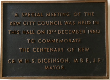 Kew Historical Society Inc
Plaque, A Special Meeting of the Kew City Council Was Held in This Hall on 13th December 1960 to Commemorate the Centenary of Kew : Cr. W.H.S. Dickinson M.B.E., J.P. Mayor, 1960
The Municipality of Kew was proclaimed on 19 December 1860, then upgraded to a Borough (1863), a Town (1910) and finally a City (1921). From 1865, its offices were based in the former Athenaeum Hall in Walpole Street, which, although extended in 1883, inevitably became inadequate. Plans for a new purpose-built Town Hall were first mooted in the late 1880s, but fell prey to six subsequent decades of debate. During that time, many sites were considered and rejected, and several schemes prepared. Finally, in 1945, it was resolved to build a new civic centre as a war memorial. The council acquired Southesk, a mansion on the south-west corner of Cotham Road and Charles Street – first mooted as a possible Town Hall site two decades earlier – and plans for a civic precinct were drawn up by John Scarborough. The project stalled until 1957, when a Town Hall Committee was formed and a new architect appointed: Harold Bartlett of Leith & Bartlett. He also proposed an entire civic precinct, of which a large public hall would constitute Stage One. Designed to accommodate almost any public or official function, the space had had a small stage at one end for intimate theatrical productions, a larger stage at the other (with operable sunken orchestra pit) for musical performances, plus the most up-to-date equipment for live TV transmission. The building, befitting its original intent as a war memorial, was also to include a sculpted monument, for which a separate design competition was held. First prize went to George H Allen (1900-1972), long-time head of the Sculpture Department at RMIT and a former war artist himself (the only one, in fact, to have worked in the medium of sculpture). At the time of the Kew project, Allen was best known for his Cenotaph at the Shrine of Remembrance (1955) and a controversial abstract sculpture at Hume House in William Street (1957). Tenders for the new hall were called and the contract (worth £104,986) was awarded to H F Yuncken. The foundation stone was laid by the Mayor, Cr F C O'Brien, on 1 June 1959. Completion (initially scheduled for October) was delayed by the unavailability of certain materials; it was barely finished in time for the official opening (by Premier Henry Bolte) on 23 April 1960. The war memorial was unveiled two days later (Anzac Day) by Bolte's deputy, the Hon A G Rylah. Fittingly, that year also marked Kew's municipal centenary, and many celebratory events were held in and around the new civic centre in December, including a special council meeting (attended by the Prime Minister), a tree planting ceremony and a youth ball. Source: Survey of Built Heritage in Victoria: Stage Two (Built Heritage Pty Ltd., 2010)Historically significant commemorative plaqueMetal plaque relating to special Council meeting to mark centenary of Kew, 13th December 1960. This plaque was given to the Kew Historical Society in 1991 by the former City of Kew.A Special Meeting Of The / Kew City Council Was Held In / This Hall On 13th December 1960 / To Commemorate / The Centenary of Kew / Cr. W.H.S. Dickinson, M.B.E., J.P., / Mayorkew city hall, foundation stones - kew (vic), cr. w.h.s. dickinson, local government -- kew (vic.) -
 Monbulk Historical Society
Ben Simcox
Bennie Simcox first came to the Monbulk area about 1860, following the first important gold discovery at the end of 1858. As the gold rush was short lived Simcox returned to Collingwood but later came back to Monbulk, built himself a hut to live in and become its first known permanent resident. The hut was burnt in the 1913 fires. Monbulk was thrown open to selection in 1894, and that's when the first farmers including Bennie Simcox went into Monbulk. It was a big, timbered country in those days. Once Ben had cleared some of his land he started to grow raspberries on it. He would be up before daylight ready to start picking. Ben also picked for a local family, the Camms to help make ends meet. When Ben Simcox was virtually at the retired stage, he wanted to develop his bit of the gully as a tourist attraction, As his nephew Fred Gay who owned the 10 acres below Ben wanted to farm, he was happy to swap his treed block with Ben. At a time when most settlers were clearing their properties, Ben Simcox, by contrast, cultivated the native plants and planted most of the large trees seen on the property today. And so Nathania Springs was developed as a tourist resort, and a mini-botanical garden. He diverted the natural water supply to form ornamental garden pools stocked with trout and tame native black fish. There were many visitors came to the Dandenongs, Some arriving in motor cars others in converted furniture vans lined with seats or charabancs with the long extended chassis and the open canvas roofs. Identities such as Billy Hughes, Madame Melba would often come to look through Nathania Springs. Bennie sold Nathania Springs to Councillor Ferdinand Thomas Le Juge, a boarding house proprietor and later the town baker in 1909 then in about 1921 Ben’s nephew Fred and his wife and family continued to open Nathania Springs to the public. It was not unusual in around 1924-25 for up to a thousand people a day to arrive at Nathania Springs to go through the gardens. At sixpence a time, that was a lot of money in those days. This photo is part of a collection of historic and social significance of the early settlement of Monbulk. Copies of photographs can be purchased from the Monbulk Historical Society.simcox, nathania springs, monbulk, 1860, berries -
 National Wool Museum
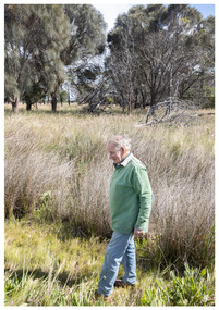
Photograph - Portrait of John Fyfe, Nicole Marie, 2021
Thousands of volunteers work tirelessly to conserve and protect the environment of Geelong and the Bellarine. Their work often goes unnoticed. In 'The Work of Nature' the National Wool Museum and the Environment Department at the City of Greater Geelong worked with photographer Nicole Marie to showcase the significant contribution of environment volunteers in our region. Each of the eight people showcased in these portraits were nominated by their peers and members of the community for their significant contribution to conserving and protecting the environment. John Fyfe - Friends of Edwards Point, the Bellarine Catchment Network and many more For over twenty years John Fyfe has been actively involved in all areas of restoring native vegetation on numerous locations throughout the Bellarine. John’s passion for caring for the environment and sharing his vast knowledge has earnt him wide respect from the community. John is not only approachable but a great communicator. His vast knowledge has made the go to person for help on support on all matters regarding revegetation. John introduced direct seeding to the Friends of Edwards Point team, which has been successful on numerous sites within Edwards Points Reserve. The approach has been adopted throughout the reserve. Reflecting on John’s impact to the local community, local residents widely refer to him as a “living legend,” while others simply say, “there should be more John Fyfe’s in the world.” Photo at Edwards Point Wildlife Reserve by Nicole Marie.Image showing an environmental portrait of a man standing in grasslands with trees in the background.environment, conservation, portraits, geelong, nature, exhibition, work of nature, geelong nature forum, volunteers, edwards point -
 Melton City Libraries
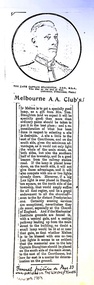
Newspaper, Melbourne A.A. Club, 1903
"Captain Simon Thomas Staughton was the son of Simon Thomas Staughton MLA who had built the mansion Eynesbury on his share of the Exford property inherited from his father Simon Staughton, the original 1840s Werribee River squatter. When the land was sold, Simon’s Exford station extended from Mt Cotterell to the Brisbane Ranges. ST Staughton (senior) was a reputedly the public spirited member of the family in his generation, being a member of the first Roads Board (and Melton Shire President in 1867), a JP, Magistrate and MLA for Bourke from 1883 until his death in 1901, whereupon his son became the MLA for Bourke. Captain ST Staughton had earlier been chosen as a member of a contingent of Victorian Mounted Riflemen sent to England for Queen Victoria’s Diamond Jubilee (1897), and was later a member of King Edward’s coronation escort. In October 1899 he had sailed for South Africa with other Mounted Riflemen from Victorian and NSW to take part in the Boer War. There he was awarded the DSO. He died of peritonitis in 1903, aged 27. He was buried in Boroondara Cemetery after a full military funeral, in which the coffin was borne on a gun carriage drawn by four black horses. All local newspapers reported eloquently on the funeral, and the late Captain’s virtues. The Staughton Memorial Lamp was given to the town by his young widow in 1903. In addition a window in the (former) Christ Church bore the inscription ‘This window is erected by his brother soldiers in loving memory of Captain S Tom Staughton, DSO, ADC, MLA’. The Staughton family had been prominent benefactors of the Church, whose altar rails were also inscribed to the much respected Captain, along with a memorial stone in the new chancel. In the 1970s the memorial was within one of four fenced tree plantations, probably erected and planted in the 1920s or 30s. When High Street and its service roads were redesigned in the 1970s the plantations were completely removed, and the Melton and District Historical Society was successful in having the memorial moved about 50 metres east to its present location". The Weekly Times article about a gift from Tom Staughtonlocal identities -
 Bacchus Marsh & District Historical Society
Plaque, Shire of Bacchus Marsh Coat of Arms
Coat of Arms used by the Shire of Bacchus Marsh in the 1980s and 1990s. A coat of arms has been in use in the Shire at least from the early 20th century. This earlier coat of arms described in 1910 featured two cows standing on two bales of lucerne hay, with lucerne fields and fruit trees and rolling hills all round a central valley with two rivers running through it. This early coat of arms was superseded by the slightly different design shown here. When this change took place is not known. When the Bacchus Marsh Shire amalgamated with other Shires to form Moorabool Shire in 1994 this design was superseded.The plaque showing the Bacchus Marsh Shire Coat of Arms is in near perfect condition and as such is an excellent example of the physical symbols used to demonstrate the presence of local government in the Bacchus Marsh region. The images on the coat of arms also depict key economic and agricultural activities in the region which provides historical information about the region in a visual and artistic way.Painted cast bronze plaque with inscription on outer white band in black capital lettering: SHIRE OF BACCHUS MARSH. Inner circle painted blue with shield and decorative branches bearing yellow leaves on either side. Shield quartered and surmounted by stylised sunrise. In four quarters, representations of significant local primary and secondary industries. SHIRE OF BACCHUS MARSH.coats of arms, shire of bacchus marsh -
Tarnagulla History Archive
Box of Murray Comrie's Research Notes (Set 2), Murray Comrie's Research Notes (Set 2), circa 1960s-80s
Murray Comrie Collection. Murray Comrie, born in Tarnagulla in 1912 also became a policeman and later a Chief Superintendent, retiring in 1972 and passing away in 1983 after a long illness. Murray Comrie's son Murray Jnr., to avoid confusion became known by his middle name, Neil. Neil Comrie also joined Victoria Police and rose through the ranks to become Chief Commissioner of Victoria Police from 1993 to 2001. Blue-grey archive box containing research notes of Murray Comrie. Contains: A series of 17 notepads in which Comrie has annotated historical information from local newspapers. A very long rolled up piece of paper on which is printed the Comrie family tree A yellow envelope containing photogrpahs which are low-quality and/or duplicates of other images in the Murray Comrie Collection. A ledger in which Comrie has listed every Police Station in Victoria and its establishment date. Four vinyl non-archival document binders in which Comrie's research notes and photographs were housed when donated. Material was transferred out of these for preservation reasons. The contents of this box were compiled or used by Murray Comrie during his research for a book about Tarnagulla. tarnagulla, comrie, research, banks, lodge, gold & mining, war/military, local people, buildings, businesses, local government, post offices, policing, recreation reserve, railway, clubs & societies, band/music, hotels, churches, schools, fire brigade, laanecoorie, names -
 Sunbury Family History and Heritage Society Inc.
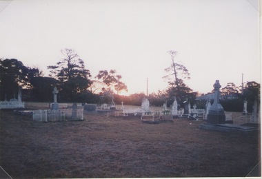
Photograph, Lydia Keyworth, Sunbury Cemetery, March 2001
The photograph of Sunbury Cemetery at sunset was entered into the Photograph Competition organised by the former Sunbury & District Heritage Association in March 2001.In 1862, land set aside in Cemetery Road for the Sunbury Cemetery was laid out in the following Christian denominational groups, Church of England, Roman Catholic, Baptist, Methodist, Presbyterian and Lutheran. Other non-denominational sites were set aside for paupers, heathens, Asians and pagans. Rebecca Jenkinson was the first person to be buried there in 1862. Over the years the size of the cemetery has expanded but it still occupies the original site off Shields Street in Sunbury and the names of the denominational divisions have changed over the years reflect a more inclusive outlook.Sunbury Cemetery replaced other smaller graveyards that were situated in some of the local church grounds and the earlier cemetery that was at The Gap township.A non-digital coloured photograph of a cemetery landscape with a number of old graves scattered across the open space. Some have small fences around them, while others simply display the headstones. There are trees in the background. sunbury cemetery, shields street, cemetery road, sunbury, cemeteries -
 Bacchus Marsh & District Historical Society
Photograph, Osage Orange Avenue Taverner Street Bacchus Marsh
A.C. (Arthur Charles) Simon a pioneer orchardist in the Bacchus Marsh district planted this avenue of Osage orange trees in about 1883, creating an imposing entrance to his property from Taverner Street. Simon also believed that the trees on his orchard property would provide a protective shelter for his other plants. Osage orange trees (Maclura pomifera) are a small deciduous tree or large shrub, native to the south-central United States. It usually grows to about 8 to 15 metres high. The distinctive fruit, a multiple fruit that resembles an immature orange, is roughly spherical in shape, about 8 to 15 centimetres in diameter, and turns bright yellow-green in the autumn. A. C. Simon is believed to have imported the Osage orange seeds from America around the 1860s and later used them to plant the trees depicted in this image. The date of this image is not certain but it probably shows the trees around the 1900s or 1910s. The avenue of trees was known for many years in Bacchus Mars as 'Simons Avenue', and were featured in a Rose series postcard dating from around 1900-1920. The remnants of this avenue or grove of trees can be seen on some of the properties on the north side of Taverner Street Bacchus Marsh and along the Werribee River west of the FIsken Street bridge.The Bacchus Marsh Heritage Study of 1995 described the Osage Orange Tree avenue as being of regional historical significance as a landscaping practice, pioneering of its type, It was also described as of local significance as a well-known landmark due to it be being represented on widely distributed post cards which depicted scenes of Bacchus Marsh in the early part of the twentieth century. This early photographic image is evidence of this social and cultural significance.A black and white photograph print mounted on mounting board showing an avenue of Osage orange trees. trees, osage orange trees, simon family bacchus marsh, arthur charles simon 1833-1924, orchardists -
 Sunbury Family History and Heritage Society Inc.
Photograph, Lydia Keyworth, The Nook, March 2001
The photograph was included in a completion organised by the former Sunbury & District Heritage Association in March 2001. It is photograph of the lake at The Nook that served as Sunbury's swimming pool from the time outdoor swimming became acceptable until 1965 when a new Olympic sized outdoor swimming pool and aquatic centre was opened in Ligar Street. The modern pool was built as a result of the Sunbury Community raising funds for the project. Since 1965, the local council has added an indoor pool and a heated pool to the site as well as a gymnasium. Prior to the building of the new pool in 1965, The Nook site was where swimming carnivals and other aquatic events took place. It is now a popular passive recreation area.A non-digital coloured photograph of a lake with trees growing around its banks and a hillside in the distance.the nook, swimming, swimming clubs, sunbury -
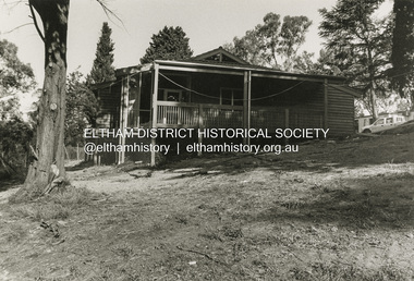
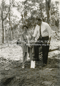 Eltham District Historical Society Inc
Photograph - Black and White Print, Shire of Eltham, Meruka Child Care Centre, turning the first sod: Cr Pamela Sladden, Peter Staples MHR Jaga Jaga, c.1993
In 1919 J.B. North, a violinist with the then Melbourne Symphonic Orchestra, and Monsieur Leon Lambert, a French architect, who later designed the Glaciarium Ice Skating Rink, purchased three available farms, Looker's, Wright's and Taylor's, approximately 60 acres, the area running along the creek and being bordered by the present day Ryans Road, Karingal Drive and Sherbourne Road. The farms were used for orchards and market gardens. Leon Lambert designed and built two homes on the farm site, one for the North family, ‘Tralford’, and the other, ‘Glen Ellen’, for himself and his wife. The homes were considered as "brother and sister" and they each included in their design an identical bay window in the main living area. "Glen Ellen" originally comprised kitchen, lounge room, inglenook, dining room, bath room and sleepout. Although the home has been extended over the years, much of the original architecture has been retained including timber panelling and three fireplaces. The land was subdivided in approximately 1966 with "Glen Ellen" retaining approximately one half acre of land fronting Meruka Drive. The property then passed from the Charleston family to Gerald and Margaret Sutton in 1976 and again was sold in 1980 and lastly sold again in 1994. The Norths named their house 'Tralford'. According to Marjorie North, the name Meruka was suggested by Alan Gardner and so was apparently not used by the North family. The name appears to be of Indian origin and its connection with the land is not known. ‘Tralford’ stayed in the North family for many years. Eltham Council acquired the house to create Meruka Park. The house was used for some years by the Council as a community arts facility and as emergency accommodation. It fell into disrepair and was demolished about 1990. The Meruka Child Care Centre has been built on the site and incorporates some of the architectural features of the old house. The Co-op was opened in April 1994. The original drive flanked by large old cypress trees remains. These trees are considered to be of local heritage significance and for this reason Meruka Park is covered by a Heritage Overlay under the Nillumbik Planning Scheme. Part of the park has been preserved as habitat for rare local flora. LL's house, named ‘Glen Ellen’, remains in a well-preserved state and fronts Meruka Drive.shire of eltham archives, child care centres, health & community services, meruka child care co-operative, peter staples mhr jaga jaga, cr pamela sladden -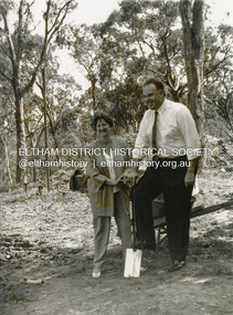
 Eltham District Historical Society Inc
Photograph - Black and White Print, Shire of Eltham, Meruka Child Care Centre, Eltham, c.1994
In 1919 J.B. North, a violinist with the then Melbourne Symphonic Orchestra, and Monsieur Leon Lambert, a French architect, who later designed the Glaciarium Ice Skating Rink, purchased three available farms, Looker's, Wright's and Taylor's, approximately 60 acres, the area running along the creek and being bordered by the present day Ryans Road, Karingal Drive and Sherbourne Road. The farms were used for orchards and market gardens. Leon Lambert designed and built two homes on the farm site, one for the North family, ‘Tralford’, and the other, ‘Glen Ellen’, for himself and his wife. The homes were considered as "brother and sister" and they each included in their design an identical bay window in the main living area. "Glen Ellen" originally comprised kitchen, lounge room, inglenook, dining room, bath room and sleepout. Although the home has been extended over the years, much of the original architecture has been retained including timber panelling and three fireplaces. The land was subdivided in approximately 1966 with "Glen Ellen" retaining approximately one half acre of land fronting Meruka Drive. The property then passed from the Charleston family to Gerald and Margaret Sutton in 1976 and again was sold in 1980 and lastly sold again in 1994. The Norths named their house 'Tralford'. According to Marjorie North, the name Meruka was suggested by Alan Gardner and so was apparently not used by the North family. The name appears to be of Indian origin and its connection with the land is not known. ‘Tralford’ stayed in the North family for many years. Eltham Council acquired the house to create Meruka Park. The house was used for some years by the Council as a community arts facility and as emergency accommodation. It fell into disrepair and was demolished about 1990. The Meruka Child Care Centre has been built on the site and incorporates some of the architectural features of the old house. The Co-op was opened in April 1994. The original drive flanked by large old cypress trees remains. These trees are considered to be of local heritage significance and for this reason Meruka Park is covered by a Heritage Overlay under the Nillumbik Planning Scheme. Part of the park has been preserved as habitat for rare local flora. LL's house, named ‘Glen Ellen’, remains in a well-preserved state and fronts Meruka Drive.shire of eltham archives, child care centres, health & community services, meruka child care co-operative -
 Eltham District Historical Society Inc
Film - Video (VHS), Jenni Mitchell, Demolition of the Shire of Eltham Offices, 1996
Poor video quality (noise and interference), incomplete and unedited raw footage. A video documenting the demolition of the Shire of Eltham offices at 895 Main Road Eltham under the direction of the Commissioners appointed for the new Shire of Nillumbik and some of the communities activities surrounding the event. The building was demolished exactly 25 years after the southern wing housing Engineering and Planning on the upper level and the Eltham Library on the ground level was opened in celebration of the Shire of Eltham's centenary. Video has lots of distortion and noise, and sections of clips dubbed over. Immediate initial footage of Jenni Mitchell talking about asbestos claims in the Shire Offices (Sigmund Jorgensen standing behind her) advising Council did a review of the building several years previously and had been cleared of health problems. Cuts to group of people standing outside front door of offices but possibly voice dub over not related ? Then the date 27 Jul 1996 on a scene flashes on screen immediately followed by an edited clip intro of title and credits with classical music track. It then opens with Jenni Mitchell driving to the Shire Offices on Saturday 27 July 1996 at 11.00am. Footage of Main Road past Pitt Street, Alistair Knox Park then entering Shire Office driveway which is fenced off and contractor signs hanging up. Scenes at rear of building showing some internal demolition has commenced. View of the Administration wing. More clips of road driving, Alistair Knox Park, Eltham Library and visitor car park for Shire Offices. Cuts to a group of people standing in access to visitor carpark with new Eltham Library in background, one being immediate former Shire of Eltham President, John Graves. Scenes of people looking through chain link fence and security guard checking front door. John Graves being filmed that someone informed him the Shire was offering the building to the Community Health Centre for $2.3 million and that if they had been offered a price of $1.1 for what it apparently was sold for they would have snapped it up. View of truck loaded with brick rubble literally struggling to ascend the hill of Library Place to exit into Main Road. Cuts to a scene looking at Eltham War memorial Hall through the Memorial Gate, then the Shillinglaw trees and large banner sign ‘Delta Demolitions’ hanging on office façade. Views of front door, old library and bluestone wall. Scene (31 Jul 1996) filmed at night of several white crosses with “RIP Community” and “RIP Democracy”. Scene (1 August 1996) again driving along Main Road towards the Shire Offices then scenes of the offices showing substantially more demolition to exterior, groups of people standing on footpath outside watching, Delta heavy demolition machines, woman holding sign “Democracy where have you gone …”, the odd person in full protection gear and breathing apparatus hand carrying materials out to place on rubbish pile in front of people standing on footpath watching (with no protection) and then stamping on it to break it creating dust, security person in hard hat (no other protection) wandering around, many groups standing around watching, news film crew, person standing on roadside edge holding signs facing traffic stating “Pirate Planning” and “ Grant us your ears” also sign on back of parked car “Elthams High Jacks”, another sign “Community Democracy”, views of crosses in Main Road median strip “RIP Community”, groups of people on footpaths and reporters conducting interviews, footage of unknown person standing with Jenni Mitchell and Sigmund Jorgensen advising people have the right to protest, Jenni Mitchell urging people to ask questions of local MP and Council and Sigmund Jorgensen referring to the three historic Shillinglaw trees with demolition machinery operating in background, Jenni Mitchell and others installing more crosses in median strip; demolition machines operating inside and outside the building, more views of onlookers including Sigmund Jorgensen then Police approaching on footpath, workers and machinery continuing to operate, views of the old library being demolished, the former Community Services department, security personnel. Scene (2 August 1996) more heavy demolition machinery in operation smashing building up, people standing around southern wing watching, view overlooking Eltham Library of train pulling in to Eltham station. Scene (7 August 1996) more heavy demolition and people wandering around with only hard hat protection, no dust protection, comments from one operator dumping a bin of material stating “wait till there’s a Hungry Jack’s here, you’ll be laughing, fuel, videos, hamburgers. You’ll be up with the rest of the world soon, you’ll have electricity and everything here, ha ha ha ha”, more heavy machinery demolition and breaking up of materials, view of Hitachi train going by and Administration wing, view inside the front door opening of the staircase leading to upper level, person walking around operating heavy machinery with a hose spraying rubble (no protective gear other than hard hat interspersed with edit cuts of meeting of Commissioners and independent observers on panel as well as members of the community in public gallery. Nillumbik Shire CEO Barry Rochford addressing the meeting., Chief Commissioner Don Cordell directly addressing Jenni Mitchell with respect to permission to take photographs, Barry Rochford continues to address the question asked of Council about the valuation of the former Shire of Eltham Office building/site, public gallery calling out asking why was building demolished, what was the urgency. Scene (14 August 1996) views of southern wing, previous single demolition operator again mocking people filming, operators working in and around building, Shillinglaw trees and largely demolished front, heavy demolition equipment at work, piles of building rubble, hose spraying water over rubble, large trucks arriving for rubble removal and loading of truck. Scene (21 August) more of the same, building virtually down, Shillinglaw trees standing tall and alone, water spraying on rubble and wattle in bloom. Cuts to Council meeting with public onlookers. Barry Rochford walks out, Wayne Phillips addresses meeting explaining one or two people shouting, members of the community challenging Council (Commissioners) about why due process appear to have been subverted. Former Shire President Robert Marshall in public audience, cuts back to Shire office carpark entrance site and sign hung on fence in front of library “Think Again!” and people standing around observing awaiting a protest demonstration erecting a large sign on stilts stating “Shell No!”, people singing a revised version of God Save the Queen (God Save Us All), Sigmund Jorgensen in attendance, Jenni Mitchell, Sigmund Jorgenson and others address the protest crowd, followed by people mingling, music being played then people standing around the cleared site circumference all with arms linked (video very broken up with noise) then chants “Save the Gateway” and “No Shell for Eltham” and more music and singing “Put up a parking lot”. The crowd then proceeds to walk along the footpath of Main Road. Scene (15 Sep 1996) meeting at Montsalvat in Great Hall addressed by Sigmund Jorgensen discussing a recently published list of the Commissioner’s to senior Council Officers of banned Nillumbik people, others encouraging people to view proposed plans for the site and lodge objections. Specific issues regarding asbestos claims are also addressed. Harry Gilham addresses the meeting on the subject of the Eltham War Memorial and Memorial Gardens and how Council believe a roundabout in the vicinity is of greater importance. Views of various artworks on display (for auction) and music performance in the Barn Gallery. Meeting addressed by Sigmund Jorgensen discussing an appeal against Council granting a permit to Dallas Howgate to develop the site and that the Minister has called the matter in to be decided by the governing council. This is followed by an auction of paintings. 0.05 - Jenni Mitchel, Sigmund Jorgensen and Peter Doughtery in background. 0.18 - Jock Kyme in front of building – David Essex, Marg Johnson on his left-hand side. 5.34 - John Graves – ex Shire of Eltham Councillor and President. 9.02 - Unknown person being interviewed. 9.30 - Jenni Mitchell, unknown person, Mark Burns, community activist. 10.04 - Sigmund Jorgenson, Jenni Mitchell. 12.04 - Police members 21.33 - Nillumbik Council offices 7 August 1996 Barry Rochford CEO, Vin Heffernan Commissioner, Don Cordell Chief Commissioner, Kevin Abbott Commissioner, unknown person. 28.00 - Barry Rochford CEO 28.05 - Kahn Frankie - in commissioner’s seat after commissioners and council staff have vacated the council chamber. 28.26 - Wayne Phillips, State Liberal member for Eltham, addressing community in response to questions. 28.36 - Mark Burns, community activist addressing gallery. 28.48 - Ken Hines, ex Shire of Eltham Councillor and President. 29.34 - Ken Hines, ex Shire of Eltham Councillor and President standing, Robert Marshall, ex Shire of Eltham Councillor and President seated in front. 29.41 - Karen Gerhards, community activist. 30.06 - Marg Johnson with loud hailer, next to Jock Kyme, community activist. 31.32 - Marg Johnson with possibly Frank Burgoyne?, Sigmund Jorgensen, Jock Kyme. 35.35 - Harry Gilham at meeting at Montsalvat on 15 September 1996. 35.43 - Sigmund Jorgenson at lectern. 36.42 - Marg Jennings. 37.47 - Mark McDonald, Jim Connor, ex Shire of Eltham Councillor in background. 36.28 - John Cohen, ex Shire of Eltham Councillor and President. 38.56 - Ken Hines, ex Shire of Eltham Councillor and President. 41.11 - Harry Gilham, president of the Eltham District Historical Society. 43.55 - Sigmund Jorgensen in Long Gallery at Montsalvat, at start of the art auction to raise funds for community action. 45.50 - Unknown person conducting art auction. VHS Video cassette (poor quality) Converted to MP4 file format 45:01, 535MBvideo recording, 895 main road, alistair knox park, artworks, auction, barn gallery, barry rochford, community health centre, dallas howgate, delta demolitions, demolition, don cordell, eltham, eltham library, eltham shire office, eltham war memorial, eltham war memorial gate, eltham war memorial hall, great hall, harry gilham, jenni mitchell, john graves, library place, main road, memorial gardens, mervyn hannan, montsalvat, pitt street, protest, robert marshall, roundabout, shell oil, shillinglaw trees, sigmund jorgensen, sign, wayne phillips -
Clunes Museum
Booklet - BOOK, HERALD PRINT, THE WEEKLY TIMES BOOK OF PATTERNS. NO. 2, CIRCA 1940
THE WEEKLY TIMES WAS THE FIRST NEWSPAPER IN VICTORIA TO ALLOT A CORNER OF ITS WOMEN'S PAGE TO "A WORK BASKET" AS THE POLICY OF THE PAPER DEMANDS THAT EACH SECTION SHOULD BE IN CHARGE OF AN EXPER, A PAGE WAS AFTERWARDS DEVOTED TO NEEDLEWORK COMPETIONS, WITH MONAY PRIZES FOR DESIGNS I CROCHET, KNITTING AND EMBROIDERY, DISCLOSED THE FACT THAT WOMEN ONLY NEEDED ENCOURAGEMENT TO PRODUCE GOOD WORK THE KNOWLEDGE THAT DESIGNES MUST BE ORIGINAL STIMULATED INTEREST. PROMPT PAYMENT AND THE SAFE RETURN OF PATTERSN, RESULITED IN A PERMANENT SUPPLY OF NEW IDEAS FROM MANY DIFFERENT PARTS OF AUSTRLAIA. A BOOK OF "WOOLIES" AFFORDS LITTLE SCOPE FOR "DESIGN", SUCH AS IS REPRESENTED IN OTHER BRANCHES OF NEEDLECRAFT. IN DESCRIBING A PATTER AS 'DESIGNED', IT PLACES THE GARMENT AS ORIGINAL, NOT MERLEY WORKED BY THE SENDER. THEIS BOOK HAS BEEN COMPLIED BECAUSE THE EVER RECURRING DEMAND FOR FAVOURITE PATTERS COULD NOT OTHERWISE BE MET BEGINNERS, WHO MAY FIND FIFFICULTY IN COPYING A PATTER, CAN HAVE ANY ENQUIRY ON THE SUBJECT ANSWERED IN THE WEEKLY TIMES. REMEMBER THAT I AM ALWAYS PLEASED TO ANSWER ENQUIRIES AND TO LEND EXAMPLES OF STITCHES. PLEASE ADDRESS YOUR LETTERS TO 'A MOTHER'. THE WEEKLY TIMES, MELBOURNEFRONT COVER DEPICTS DARK BLUE BACKGROUND OF TREES AND SUNRISE IN THE SKY, SOFT COVER, IMAGE OF MAN AND LADY STANDING, WOMAN IN PROFILE IN A CIRCLE AND IMAGE OF WHITE KNITTED BONNET WITHIN A DIAMOND SHAPE. THE WEEKLY TIMES BOOK OF PATTERNS. NO. 2local history, book, reference, trembath, perry -
 Eltham District Historical Society Inc
Photograph - Digital Photograph, Alan King, Stonygrad, 34 Hamilton Road, North Warrandyte, 30 January 2008
Vassilieff dynamited rock from his own property to build his house. Stonygrad is reminiscent of a grotto and in parts, of a sculpture. Covered under Heritage Overlay, Nillumbik Planning Scheme. Published: Nillumbik Now and Then / Marguerite Marshall 2008; photographs Alan King with Marguerite Marshall.; p135 Stonygrad, the home built by Expressionist painter and sculptor Danila Vassilieff, is reminiscent of a grotto and in parts, of a sculpture. Vassilieff, who amongst others influenced painter Sydney Nolan and Albert Tucker, was a member of the artists group the Angry Penguins. He was also a highly regarded art teacher at the nearby Koornong Experimental School and taught at Eltham High School. Art critic Robert Hughes described Vassilieff’s painting as ‘lyrical without social commentary’, and said Vassilieff was ‘the most oddly neglected artist in recent Australian History’. Vassilieff, who was born in 1897 in Russia, had an unusually adventurous life before he settled in Warrandyte. The 12th of 18 children, he lived on a farm in the Don Basin. Vassilieff trained with the Imperial Military Academy at St Petersburg and fought in World War One as an officer in the White Russian Army against the communists. In 1920 he was captured, then escaped from prison, stole a horse and rode bareback 150 miles to the Black Sea, helped at first by Tartar freebooters. He then travelled to India, Shanghai and arrived in Queensland as a refugee in 1923 where he began painting. He and his wife Anisia bought a sugar farm near Ingram, and later he constructed railway lines at Mataranka, in the Northern Territory.4 In 1929 Vassilieff went to Brazil for formal art training from former fellow-officer Dmitri Ismailovich, but he soon left to travel up the Amazon River. He then worked as a sidewalk artist in the West Indies and travelled for two years in England, France and Spain. In 1937 he arrived in Melbourne where he lived until his death in 1958. His first major Australian series was the Carlton streetscapes and from 1951 he sculpted in local hard limestone. Vassilieff rejected all dogma and regarded religious subjects as suitable only for decorative arts. In 1944 he helped defeat a communist attempt to take over the Contemporary Art Society. For a short time, from around 1955, Vassilieff taught at various Victorian schools. The Angry Penguins painted mainly between 1937 and 1947, and included Arthur Boyd, Albert Tucker, Sidney Nolan and Joy Hester. The group formed as they felt isolated from European thought and art (including Surrealism) from which their work was derived. They were also angry at what they considered to be the complacency and insularity of their society. They maintained Australians at first were scarcely aware of the threats of the Wall Street Crash and Hitler and were little interested in the Spanish Civil War. The Angry Penguins also objected to the White Australia Policy. Hughes said although most of the Melbourne Expressionists in the 1940s were unskilled and their work crude in style, they helped jolt Australian painting from its pastoral complacency. Their style influenced nearly every painting produced by significant figurative artists in Melbourne in the 1950s such as Charles Blackman. From 1939 Vassilieff built Stonygrad, mainly with local stone. The house stands at the end of a private road surrounded by trees with the quiet occasionally broken by the sounds of bellbirds. To build his house Vassilieff dynamited rock and cut trees from his own property. The original section of the three-level house is of irregular-shaped pieces of solid stone, exposed inside like the exterior. Vassilieff later built sections with timber and brick. Inside is rustic and cave-like, and several rooms are linked by arched openings with no doors. One undulating wall was carved out of rock from which two sculptured heads protrude. Several ceilings are of rough-hewn logs and the built-in table and bookcase are rough, as is a timber ladder leading to a bedroom. Not for the elderly or unsteady! Yet the general impression in the muted light is beautiful, with artistic originality.This collection of almost 130 photos about places and people within the Shire of Nillumbik, an urban and rural municipality in Melbourne's north, contributes to an understanding of the history of the Shire. Published in 2008 immediately prior to the Black Saturday bushfires of February 7, 2009, it documents sites that were impacted, and in some cases destroyed by the fires. It includes photographs taken especially for the publication, creating a unique time capsule representing the Shire in the early 21st century. It remains the most recent comprehenesive publication devoted to the Shire's history connecting local residents to the past. nillumbik now and then (marshall-king) collection, danila vassilieff, hamilton road, north warrandyte, stonygrad -
 Lakes Entrance Historical Society
Photograph - Historic House, Bennett, Vera, 1991
Date made May 1991|Old building demolished c2008. Ostler family arrived at Cunninghame (Lakes Entrance) by boat, walked to the site with their belongings, cleared the land, built a dwelling, farmed dairy herd, grew maize, had beehives.| Also one colour photograph of new dwelling constructed next to the old dwelling taken 29th September 2007|Also two other colour photographs old dwelling.Colour photograph of Ostlers old home, 106 Ostlers Road, showing a timber and corrugated iron structure amongst farm buildings and trees. Lakes Entrance Victoriahouses, local history -
 Eltham District Historical Society Inc
Photograph - Digital Photograph, Alan King, Graves of Thomas Sweeney and family, Eltham Cemetery, Victoria, 27 January 2008
The grave of Thomas Sweeney, former convict turned respectable citizen. The Murray and Sweeney families were both early settlers of the Eltham district and connected by marriage. Their family plots are located side by side in the Catholic section of the Eltham Cemetery. Irish-born Thomas Sweeney is regarded as the first settler in Eltham. He was transported to Sydney in 1823 after being convicted of arson. He was granted his freedom in 1838 and married Margaret Meehan in the same year. They moved to Melbourne and in 1842 Thomas purchased 110 acres beside the Yarra River in the vicinity of present-day Sweeneys Lane. He called the property ‘Culla Hill’ and built a small slab hut (reputedly with Wurundjeri help; Margaret is said to have run an informal hospital for them in return). This was followed in 1846 by more substantial buildings consisting of a three-roomed Irish-style ‘longhouse’ and a barn made of stone and handmade bricks, with doors large enough to accommodate a fully loaded wagon. When the gold rush came, Thomas prospered by selling meat and potatoes to the prospectors, enabling him to purchase a further 308 acres in 1856. He promoted the construction of a bridge over the Plenty River and the establishment of a school at Eltham. Roman Catholic Church services were held at Culla Hill in the early years. When he died in 1867, he was regarded as a respected member of the community. Thomas and Margaret are buried in Eltham Cemetery with many of their descendants. Their first son John continued to farm Culla Hill until his death in 1909. Culla Hill passed out of the Sweeneys' possession in 1939. The house and barn remain today, though lesser outbuildings have gone. The facade of the house is much the same as it was in the 1840s. Sacred To the memory of Thomas Sweeney Who died Sep 6th 1867 Aged 65 years May his soul res in peace Also his wife Margaret Died Oct 3rd 1884 aged 73 years And their daughters Annie Died Aug 22nd 1860 aged 21 years Johanna Died Aug 19th 1872 aged 22 years Margaret Died 7th Sep 1913 aged 72 years R.I.P. Also In Memory Of John Sweeney Died 24th May 1909 Aged 65 years Also of his wife Ellen Died 8th March 1910 Aged 64 years R.I.P Also In Memory Of Caroline Infant daughter of John & Ellen Sweeney Published: Nillumbik Now and Then / Marguerite Marshall 2008; photographs Alan King with Marguerite Marshall.; p55 From the piety and poverty of 19th century Eltham, 20th century artists and environmentalists, to today’s comfortable middle class, Eltham Cemetery records it all — and more. A visit to Eltham Cemetery reveals an important social record since its beginnings in 1858. The cemetery was situated on about six acres (2.4ha) (now around 4.8ha) at the corner of Mount Pleasant and Metery Roads.1* It is thought that Metery Road was originally called Cemetery Road, but in the early 1940s, a resident, possibly a councillor, objected to the name resulting in the change.2 Much can be gleaned about the developing Eltham community from burial styles and the names of former local residents. Originally the cemetery was divided into Christian denominations, like others of that time, following the United Kingdom burial system. In 1861 the cemetery included Church of England, Presbyterian, Roman Catholic and Wesleyans (later Methodist) sites. Graves also indicated social class. Some had grand tombstones, perhaps fenced with ornamental cast iron railing, but most in the 1860s and 1870s were constructed of modest stone slabs.3 This indicated the poverty of the district, which was largely inhabited by farmers on small landholdings. A poignant reminder of the high rates of infant mortality of those times, are the many infants and young children recorded on the headstones. Major changes occurred in the cemetery in the late 20th century as Christian adherence weakened and society became more egalitarian and informal. In the early 1970s a non-denominational lawn section for burials was established. Since then all new areas have been non-denominational to accommodate the more diverse local community. Now, instead of large ornamental headstones, some mourners have chosen boulders, reflecting the natural Eltham style, while others choose graves in the lawn areas or niches in walls. In the late 1970s, the University Donor Section was established north-west of Candlebark Lawn for those who donated their bodies for The University of Melbourne medical research. In the early 1980s the natural Australian garden style, popular in Eltham, was mirrored in a new section called Ashes Walk. Local landscape architect Gordon Ford, who had popularised this style, designed the Walk using boulders shaded by native plants beside curved pathways. Landscape architect Robert Boyle later redesigned Ashes Walk and developed other parts of the cemetery in keeping with this style.4 Appropriately Ford, who died in 1999, was interred in the Native Garden Section in a cluster of sites shaded by a large eucalyptus tree.5 By 2007, about 6400 interments were recorded in the Eltham Cemetery. Close inspection reveals notable names in the district’s history. The grave of Thomas Sweeney, a former convict who became a respected citizen, can be found in the Roman Catholic section near the path. Eltham Primary School’s first headmaster, David Clark, is buried in a modest grave in the Church of England section to the east of the path from the main entrance. Sir William Irvine, Victorian Premier from 1900 to 1902, whose grave is in the north-east Presbyterian section was at various times Victoria’s Chief Justice, Deputy Governor and Treasurer.6 Further south is the grave of social reformer Bertram Wainer, born in Scotland in 1928 and died in 1987. He campaigned to legalise abortion and exposed police corruption in allowing illegal ‘backyard’ abortions. Other prominent local residents interred in the cemetery include: Justus Jörgensen, who founded Montsalvat; Alistair Knox, the mud-brick housing pioneer and Eltham Shire Councillor from 1971 to 1975 and President in 1975; Clem and Nina Christensen, who had a major influence on the literary development of post World War Two Australia. Others were: composer Dorian Le Gallienne; artist Peter Glass; Stephen Dattner, a prominent Melbourne furrier; ALP parliamentarian for Greensborough, Pauline Toner and political scientist and commentator, Professor William Macmahon Ball.This collection of almost 130 photos about places and people within the Shire of Nillumbik, an urban and rural municipality in Melbourne's north, contributes to an understanding of the history of the Shire. Published in 2008 immediately prior to the Black Saturday bushfires of February 7, 2009, it documents sites that were impacted, and in some cases destroyed by the fires. It includes photographs taken especially for the publication, creating a unique time capsule representing the Shire in the early 21st century. It remains the most recent comprehenesive publication devoted to the Shire's history connecting local residents to the past. nillumbik now and then (marshall-king) collection, annie sweeney, caroline sweeney, ellen sweeney, eltham cemetery, graves, gravestones, johanna sweeney, john murray, john sweeney, margaret sweeney, mary ellen drain, mary murray, thomas murray, thomas sweeney -
 Eltham District Historical Society Inc
Photograph - Digital Photograph, Marguerite Marshall, One Tree Hill Mine, Smiths Gully, 8 June 2006
Gold was discovered on One Tree Hill in 1854. The site has been worked intermittently until fairly recent times. Published: Nillumbik Now and Then / Marguerite Marshall 2008; photographs Alan King with Marguerite Marshall.; p53 Though still a working mine, One Tree Hill Mine at Smiths Gully, now stands in a tranquil reserve surrounded by bush and native animals - in contrast to its heyday. In the mid 19th century, when the mine was part of the Caledonia Goldfields, hundreds of men in search of their fortune worked the alluvial gold in the Yarra River, its tributaries and the reefs that made up the goldfields. Miner Stan Bone, assisted by Wilfred Haywood, is the last of the independent gold miners in the area and still uses the quartz crushing battery as miners did when gold was first discovered in the area in 1851.1 Stan, who is the last of six generations of miners in his family, was aged 17 when he began mining on his father Alex’ mine, The Golden Crown in Yarrambat. These days, after blasting the gold-bearing rock in Mystery Reef, one of the four reefs at One Tree Hill, Stan transports it around five kilometres by tip truck to the Black Cameron Mine for crushing. There he uses water from the waterlogged mine, (which still contains gold), as the Happy Valley Creek at One Tree Hill is usually dry.2 The One Tree Hill Mine has been worked for close to a century since it opened around the late 1850s.3 The Swedish Reef was its most productive reef and one of the largest in the area. Around 1859, extractions included 204 ounces (5.8kg) of gold, won from 57 pounds (26kg) of stone.4 Then during World War Two, Stan’s uncle, Bill Wallace, and Alex Bone, closed the mine. In 1973, Stan, with his Uncle Bill, reopened the Black Cameron Mine and worked there until 1988. Stan resumed mining One Tree Hill in 1998. As late as the 1920s gold was picked up by chance! When crossing a gully on his way to vote at the St Andrews Primary School, Bill Joyce picked up some quartz containing gold. This site was to become the Black Cameron Mine. The Caledonia Diggings, named after Scotland’s ancient name by local Scots, began around Market Square (now Smiths Gully) and included Queenstown (St Andrews), Kingstown (Panton Hill) and Diamond Creek. There were also poorer bearing fields in Kangaroo Ground and Swipers Gully (now Research). * None of these compared in riches to the Ballarat and Bendigo fields5, but the Caledonia Diggings continued intermittently for close to 100 years. Gold was discovered in Victoria following a bid to stem the disappearance of much needed workmen to the New South Wales diggings. Several businessmen offered a reward of £200, for the discovery of gold within 200 miles (322 km) of Melbourne. Late in June 1851, gold was first discovered at Andersons Creek, Warrandyte. Then in 1854, George Boston and two other men discovered gold at Smiths Gully. Gold transformed the quiet districts, with a constant flow of families and vehicles on the dirt tracks en route to the Caledonia Diggings. Three thousand people worked the gullies in Market Square, including about 1000 Chinese miners. The square established its own police, mining warden, gold battery, school, shops and cemetery and grog flowed. Market Square flourished until the middle 1860s. Bullocks transported quartz from the Caledonia Goldfields to the crushing machinery at the Queenstown/St Andrews Battery, near Smiths Gully Cemetery. It was destroyed by bushfire in 1962. By the late 1850s, most early alluvial fields were in decline, but minor rushes continued until around 1900 and some until the early 1940s. Some miners did well, although most earned little from their hard labour in the harsh and primitive conditions.6 But according to historian, Mick Woiwod, the gold fields helped to democratise society, as individuals from all walks of life were forced to share experiences, and the ability to succeed, depended less on inherited wealth or social rank.This collection of almost 130 photos about places and people within the Shire of Nillumbik, an urban and rural municipality in Melbourne's north, contributes to an understanding of the history of the Shire. Published in 2008 immediately prior to the Black Saturday bushfires of February 7, 2009, it documents sites that were impacted, and in some cases destroyed by the fires. It includes photographs taken especially for the publication, creating a unique time capsule representing the Shire in the early 21st century. It remains the most recent comprehenesive publication devoted to the Shire's history connecting local residents to the past. nillumbik now and then (marshall-king) collection, gold mining, one tree hill mine, smiths gully -
 Eltham District Historical Society Inc
Photograph - Digital Photograph, Marguerite Marshall, Strathewen Public Hall, 20 August 2008
Strathewen Public Hall, social and spiritual centre was later lost in the Black Saturday fires 2009. The Strathewen Community decided a community hall was needed in 1901. In 1902 locals built the hall with messmate trees. It was located on the Cottlesbridge-Strathewen Road. The first function was a Grand concert and Balll attended by about 120 people. Several denominations held Church services and Sunday School services in the Hall. It survived several bushfires until after this photo was taken when it was destroyed in Black Saturday, 9 February 2009. Published: Nillumbik Now and Then / Marguerite Marshall 2008; photographs Alan King with Marguerite Marshall.; p89 Strathewen was settled late, largely because it was difficult to access.1 Early selectors found it a struggle to survive. They had to do everything themselves, from felling trees for buildings, to taking produce to market along bush tracks that they had helped cut. Small dairy farms were typical but fruit became the district’s prime produce. The first settlers east of Arthurs Creek were brothers John and Duncan Smith whose station Glen-Ard was probably operated as a sheep run. Other early settlers were the Mann family, who were to donate land for the hall, provide postal services and John Mann was an Eltham Shire councillor from 1916 to 1919.2 In 1873 James Mann, his wife Jane and their six children, settled on 207 acres (83.7) (Lang Fauld Farm) on both sides of Eagles Nest Road, from the foot of Mount Sugarloaf to the bank of the Arthurs Creek. In 1883 James took up another selection on Chads Creek. It was very hard work and at times he was well behind with his rent. However the family had a good social life, attending the Primitive Methodist Church at the Arthurs Creek Township and on New Year’s Eve throwing a party for all the locals. By 1874 James Mann’s younger brother, John, selected 311 acres (125.8ha) between Eagles Nest Road and upper Arthurs Creek. He called it Carseburn after his home parish in Scotland. Tragically in 1875 John drowned in the Yarra River, at Richmond.3 John Mann’s oldest son, also John, later purchased Duncan Smith’s land, which he named Violet Glen. He was to give one acre (0.4ha) of this land for the Strathewen Hall site. A Mann family diary written at Carseburn in 1897, tells how the district’s name was selected. Strathewen is derived from ‘strath’ meaning ‘broad mountain valley’ and from the name of Ewen H. Cameron, the local parliamentarian for almost 40 years. ‘George Brain came around to get a petition signed to get a post office up here and we had to vote for a name—Strathewen, Glen-Ard, or Headcorie’.4 It was at Carseburn that a public meeting in 1901, decided to build the Strathewen Hall on the Cottlesbridge-Strathewen Road. In 1902 the locals built the hall with messmate trees. The first function was a Grand Concert and Ball attended by around 120 people and several Protestant denominations took turns to hold church services and Sunday School there. Fortunately the hall has survived bushfires to be the town’s spiritual and social centre.5 The area continued to develop and in 1909 a post office operated somewhere at Strathewen and from around 1916 at Carseburn.6 It was not until 1914 that land was bought to establish the Strathewen State School on School Ridge Road. The residents paid £100 to build it on two acres (0.8 ha) while the Education Department contributed £30 and leased the building annually for £1. When teacher Miss Mary Golding opened the school in 1917, it had no equipment.7 But in 1921 the Education Department provided desks and a hexagonal shelter shed (now a rare style in Victoria) and took control in 1925.8 By 1917 Strathewen was booming.9 George Apted had built a coolstore in 1916, and local orchardists bought storage space until the 1950s. This allowed the area to supply the market in and out of season. Guesthouses catered for growing tourism. In the mid 1920s Mrs Eleanor Sparkes built the guest-house Singing Waters, which operated through the 1930s. Her daughter Mrs Vera McKimmie, ran it until the 1950s and the house remains in Chads Creek Road. In the Great Depression land was cleared for timber to be sold as firewood and there was small scale sawmilling. However the orchard industry diminished for several reasons including the 1939 bushfires and rapid changes in production methods. Today the Apteds still operate an orchard and farm at Glen-Ard, which straddles the border between Strathewen and Arthurs Creek. It includes the southern part of Duncan Smith’s original Glen-Ard selection.This collection of almost 130 photos about places and people within the Shire of Nillumbik, an urban and rural municipality in Melbourne's north, contributes to an understanding of the history of the Shire. Published in 2008 immediately prior to the Black Saturday bushfires of February 7, 2009, it documents sites that were impacted, and in some cases destroyed by the fires. It includes photographs taken especially for the publication, creating a unique time capsule representing the Shire in the early 21st century. It remains the most recent comprehenesive publication devoted to the Shire's history connecting local residents to the past. nillumbik now and then (marshall-king) collection, strathewan public hall -
 Eltham District Historical Society Inc
Photograph - Digital Photograph, Marguerite Marshall, Art Gallery at Clifton Pugh's Artists' Colony, Dunmoochin, Barreenong Road, Cottles Bridge, 5 February 2008
Art Gallery with mural painted by Clifton Pugh (1924-1990) at his Artists' Colony, Dunmoochin, Barreenong Road, Cottles Bridge. Following military service in the second world war, Clifton Pugh studied under artist Sir William Dargie at the National Gallery School in Melbourne as well as Justus Jorgensen, founder of Montsalvat. For a while he lived on the dole but also worked packing eggs for the Belot family saving sufficient to purchase six acres (2.4 ha) of land at Barreenong Road, Cottles Bridge. He accumulated more land and persuaded several other artists and friends to buy land nearby, resulting in a property of approximately 200 acres, stablishing it as one of the first artistic communes in Australia alongside Montsalvat in Eltham. It was around 1951 that Pugh felt he had '"done moochin' around" and so the name of the property evolved. He bought timber from Alistair Knox to build his house on the crest of a hill. Inspired by local goldminer's huts, it was a one room wattle-and-daub structure with dirt floor. Over the years it expanded with thick adobe walls made from local clay, high ceilings and stone floors. All materials other than the local earth were sourced from second hand materials, most found at wreckers' yards. Artists from across the nation were drawn to Dunmoochin, with several setting up houses and shacks on the property, maintaining their independence but sharing their artistic zeal. Artists who worked or resided at Dunmoochin included Mirka Mora, John Perceval, Albert Tucker, Fred Williams, Charles Blackman, Arthur Boyd and John Olsen. In 2002, Pugh's house along with its treasure trove of art and a library of some 20,000 books was destroyed by fire. Traces of Pugh's home remain with the presence of the Victorian doorframe archway with leadlight of intricate design, procured from a demolished Melbourne mansion; and two bronze life-sized female statues created by Pugh and cast by Matcham Skipper. In place of Pugh's house rose two double-storey mud-brick artists' studios topped with corrugated iron rooves curved like the wings of a bird with accommodation for seven. The original studios, gallery and other buildings survived the fire. Covered under Heritage Overlay, Nillumbik Planning Scheme. Published: Nillumbik Now and Then / Marguerite Marshall 2008; photographs Alan King with Marguerite Marshall.; p153 It’s not surprising that artist Clifton Pugh was drawn to Cottles Bridge to establish his artists’ colony Dunmoochin. Undisturbed by the clamour of modern life at Barreenong Road, Pugh was surrounded by the Australian bush he loved, and where his ashes were later scattered. The 200 acres (81ha) of bushland, broken by glimpses of rolling hills, has more than 50 species of orchids and Pugh shared his property with native animals including kangaroos, emus, phascogales, wombats, and diverse bird life. Pugh encouraged these creatures to join him in the bush by creating, with Monash University, a holding station where the animals were raised. Dunmoochin inspired Pugh for such paintings as in a book on orchids and the Death of a Wombat series.1 But his love for the bush was accompanied by the fear that Europeans were destroying it and much of his painting illustrated this fear and his plea for its conservation.2 However it was his house rather than the surrounding bush that was to be destroyed. Tragically in 2002 Pugh’s house, with its treasure of art and library of 20,000 art books, was destroyed by fire. Traces of the beauty of Pugh’s home still remain, however, in the magnificent Victorian doorframe archway with leadlight of intricate design procured from a demolished Melbourne mansion; and two bronze life-sized female statues created by Pugh and cast by Matcham Skipper. Now in place of Pugh’s house, are two double-storey mud-brick artists’ studios topped with corrugated roofs curved like birds’ wings, with accommodation for seven. The original studios, gallery and other buildings remain.3 Pugh grew up on his parents’ hobby farm at Briar Hill and attended the Briar Hill Primary School, then Eltham High School and later Ivanhoe Grammar. At 15 he became a copy boy for the Radio Times newspaper, then worked as a junior in a drafting office. Pugh was to have three wives and two sons. After serving in World War Two in New Guinea and Japan, Pugh studied under artist Sir William Dargie, at the National Gallery School in Melbourne.4 Another of his teachers was Justus Jörgensen, founder of Montsalvat the Eltham Artists’ Colony. Pugh lived on the dole for a while and paid for his first six acres (2.4ha) at Barreenong Road by working as an egg packer for the Belot family. Pugh accumulated more land and persuaded several other artists and friends to buy land nearby, resulting in the 200 acre property. They, too, purchased their land from the Belot family by working with their chickens. Around 1951 Pugh felt he had ‘Done moochin’ around’ and so the name of his property was born. Pugh bought some used timber from architect Alistair Knox to build his house on the crest of a hill. Inspired by local goldminers’ huts it was a one-room wattle-and-daub structure with a dirt floor. It was so small that the only room he could find for his telephone was on the fork of a tree nearby.5 Over the years the mud-brick house grew to 120 squares in the style now synonymous with Eltham. It had thick adobe walls (sun-dried bricks) made from local clay, high ceilings and stone floors with the entire structure made of second-hand materials – most found at wreckers’ yards. Pugh’s first major show in Melbourne in 1957, established him as a distinctive new painter, breaking away from the European tradition ‘yet not closely allied to any particular school of Australian painting’.6 Pugh became internationally known and was awarded the Order of Australia. He won the Archibald Prize for portraiture three times, although he preferred painting the bush and native animals. In 1990 not long before he died, Pugh was named the Australian War Memorial’s official artist at the 75th anniversary of the landing at Gallipoli. Today one of Pugh’s legacies is the Dunmoochin Foundation, which gives seven individual artists or couples and environmental researchers the chance to work in beautiful and peaceful surroundings, usually for a year. By November 2007, more than 80 people had taken part, and the first disabled artist had been chosen to reside in a new studio with disabled access.1 In 1989, not long before Pugh died in 1990 of a heart attack at age 65, he established the Foundation with La Trobe University and the Victorian Conservation Trust now the Trust for Nature. Pugh’s gift to the Australian people – of around 14 hectares of bushland and buildings and about 550 art works – is run by a voluntary board of directors, headed by one of his sons, Shane Pugh. La Trobe University in Victoria stores and curates the art collection and organises its exhibition around Australia.2 The Foundation aims to protect and foster the natural environment and to provide residences, studios and community art facilities at a minimal cost for artists and environmental researchers. They reside at the non-profit organisation for a year at minimal cost. The buildings, some decorated with murals painted by Pugh and including a gallery, were constructed by Pugh, family and friends, with recycled as well as new materials and mud-bricks. The Foundation is inspired by the tradition begun by the Dunmoochin Artists’ Cooperative which formed in the late 1950s as one of the first artistic communes in Australia. Members bought the land collaboratively and built the seven dwellings so that none could overlook another. But, in the late 1960s, the land was split into private land holdings, which ended the cooperative. Dunmoochin attracted visits from the famous artists of the day including guitarists John Williams and Segovia; singer and comedian Rolf Harris; comedian Barry Humphries; and artists Charles Blackman, Arthur Boyd and Mirka Mora. A potters’ community, started by Peter and Helen Laycock with Alma Shanahan, held monthly exhibitions in the 1960s, attracting local, interstate and international visitors – with up to 500 attending at a time.3 Most artists sold their properties and moved away. But two of the original artists remained into the new millennium as did relative newcomer Heja Chong who built on Pugh’s property (now owned by the Dunmoochin Foundation). In 1984 Chong brought the 1000-year-old Japanese Bizan pottery method to Dunmoochin. She helped build (with potters from all over Australia) the distinctive Bizan-style kiln, which fires pottery from eight to 14 days in pine timber, to produce the Bizan unglazed and simple subdued style. The kiln, which is rare in Australia, is very large with adjoining interconnected ovens of different sizes, providing different temperatures and firing conditions. Frank Werther, who befriended Pugh as a fellow student at the National Gallery Art School in Melbourne, built his house off Barreenong Road in 1954. Werther is a painter of the abstract and colourist style and taught art for about 30 years. Like so many in the post-war years in Eltham Shire, as it was called then, Werther built his home in stages using mud-brick and second-hand materials. The L-shaped house is single-storey but two-storey in parts with a corrugated-iron pitched roof. The waterhole used by the Werthers for their water supply is thought to be a former goldmining shaft.4 Alma Shanahan at Barreenong Road was the first to join Pugh around 1953. They also met at the National Gallery Art School and Shanahan at first visited each weekend to work, mainly making mud-bricks. She shared Pugh’s love for the bush, but when their love affair ended, she designed and built her own house a few hundred yards (metres) away. The mud-brick and timber residence, made in stages with local materials, is rectangular, single-storey with a corrugated-iron roof. As a potter, Shanahan did not originally qualify as an official Cooperative member.This collection of almost 130 photos about places and people within the Shire of Nillumbik, an urban and rural municipality in Melbourne's north, contributes to an understanding of the history of the Shire. Published in 2008 immediately prior to the Black Saturday bushfires of February 7, 2009, it documents sites that were impacted, and in some cases destroyed by the fires. It includes photographs taken especially for the publication, creating a unique time capsule representing the Shire in the early 21st century. It remains the most recent comprehenesive publication devoted to the Shire's history connecting local residents to the past. nillumbik now and then (marshall-king) collection, art gallery, clifton pugh, dunmoochin, cottlesbridge, cottles bridge, barreenong road -
 Eltham District Historical Society Inc
Photograph - Digital Photograph, Marguerite Marshall, Doorway of Clifton Pugh's former house at Dunmoochin, Barreenong Road, Cottles Bridge, 5 February 2008
Following military service in the second world war, Clifton Pugh studied under artist Sir William Dargie at the National Gallery School in Melbourne as well as Justus Jorgensen, founder of Montsalvat. For a while he lived on the dole but also worked packing eggs for the Belot family saving sufficient to purchase six acres (2.4 ha) of land at Barreenong Road, Cottles Bridge. He accumulated more land and persuaded several other artists and friends to buy land nearby, resulting in a property of approximately 200 acres, stablishing it as one of the first artistic communes in Australia alongside Montsalvat in Eltham. It was around 1951 that Pugh felt he had '"done moochin' around" and so the name of the property evolved. He bought timber from Alistair Knox to build his house on the crest of a hill. Inspired by local goldminer's huts, it was a one room wattle-and-daub structure with dirt floor. Over the years it expanded with thick adobe walls made from local clay, high ceilings and stone floors. All materials other than the local earth were sourced from second hand materials, most found at wreckers' yards. Artists from across the nation were drawn to Dunmoochin, with several setting up houses and shacks on the property, maintaining their independence but sharing their artistic zeal. Artists who worked or resided at Dunmoochin included Mirka Mora, John Perceval, Albert Tucker, Fred Williams, Charles Blackman, Arthur Boyd and John Olsen. In 2002, Pugh's house along with its treasure trove of art and a library of some 20,000 books was destroyed by fire. Traces of Pugh's home remain with the presence of the Victorian doorframe archway with leadlight of intricate design, procured from a demolished Melbourne mansion; and two bronze life-sized female statues created by Pugh and cast by Matcham Skipper. In place of Pugh's house rose two double-storey mud-brick artists' studios topped with corrugated iron rooves curved like the wings of a bird with accommodation for seven. The original studios, gallery and other buildings survived the fire. Covered under Heritage Overlay, Nillumbik Planning Scheme. Published: Nillumbik Now and Then / Marguerite Marshall 2008; photographs Alan King with Marguerite Marshall.; p155 It’s not surprising that artist Clifton Pugh was drawn to Cottles Bridge to establish his artists’ colony Dunmoochin. Undisturbed by the clamour of modern life at Barreenong Road, Pugh was surrounded by the Australian bush he loved, and where his ashes were later scattered. The 200 acres (81ha) of bushland, broken by glimpses of rolling hills, has more than 50 species of orchids and Pugh shared his property with native animals including kangaroos, emus, phascogales, wombats, and diverse bird life. Pugh encouraged these creatures to join him in the bush by creating, with Monash University, a holding station where the animals were raised. Dunmoochin inspired Pugh for such paintings as in a book on orchids and the Death of a Wombat series.1 But his love for the bush was accompanied by the fear that Europeans were destroying it and much of his painting illustrated this fear and his plea for its conservation.2 However it was his house rather than the surrounding bush that was to be destroyed. Tragically in 2002 Pugh’s house, with its treasure of art and library of 20,000 art books, was destroyed by fire. Traces of the beauty of Pugh’s home still remain, however, in the magnificent Victorian doorframe archway with leadlight of intricate design procured from a demolished Melbourne mansion; and two bronze life-sized female statues created by Pugh and cast by Matcham Skipper. Now in place of Pugh’s house, are two double-storey mud-brick artists’ studios topped with corrugated roofs curved like birds’ wings, with accommodation for seven. The original studios, gallery and other buildings remain.3 Pugh grew up on his parents’ hobby farm at Briar Hill and attended the Briar Hill Primary School, then Eltham High School and later Ivanhoe Grammar. At 15 he became a copy boy for the Radio Times newspaper, then worked as a junior in a drafting office. Pugh was to have three wives and two sons. After serving in World War Two in New Guinea and Japan, Pugh studied under artist Sir William Dargie, at the National Gallery School in Melbourne.4 Another of his teachers was Justus Jörgensen, founder of Montsalvat the Eltham Artists’ Colony. Pugh lived on the dole for a while and paid for his first six acres (2.4ha) at Barreenong Road by working as an egg packer for the Belot family. Pugh accumulated more land and persuaded several other artists and friends to buy land nearby, resulting in the 200 acre property. They, too, purchased their land from the Belot family by working with their chickens. Around 1951 Pugh felt he had ‘Done moochin’ around’ and so the name of his property was born. Pugh bought some used timber from architect Alistair Knox to build his house on the crest of a hill. Inspired by local goldminers’ huts it was a one-room wattle-and-daub structure with a dirt floor. It was so small that the only room he could find for his telephone was on the fork of a tree nearby.5 Over the years the mud-brick house grew to 120 squares in the style now synonymous with Eltham. It had thick adobe walls (sun-dried bricks) made from local clay, high ceilings and stone floors with the entire structure made of second-hand materials – most found at wreckers’ yards. Pugh’s first major show in Melbourne in 1957, established him as a distinctive new painter, breaking away from the European tradition ‘yet not closely allied to any particular school of Australian painting’.6 Pugh became internationally known and was awarded the Order of Australia. He won the Archibald Prize for portraiture three times, although he preferred painting the bush and native animals. In 1990 not long before he died, Pugh was named the Australian War Memorial’s official artist at the 75th anniversary of the landing at Gallipoli. Today one of Pugh’s legacies is the Dunmoochin Foundation, which gives seven individual artists or couples and environmental researchers the chance to work in beautiful and peaceful surroundings, usually for a year. By November 2007, more than 80 people had taken part, and the first disabled artist had been chosen to reside in a new studio with disabled access.1 In 1989, not long before Pugh died in 1990 of a heart attack at age 65, he established the Foundation with La Trobe University and the Victorian Conservation Trust now the Trust for Nature. Pugh’s gift to the Australian people – of around 14 hectares of bushland and buildings and about 550 art works – is run by a voluntary board of directors, headed by one of his sons, Shane Pugh. La Trobe University in Victoria stores and curates the art collection and organises its exhibition around Australia.2 The Foundation aims to protect and foster the natural environment and to provide residences, studios and community art facilities at a minimal cost for artists and environmental researchers. They reside at the non-profit organisation for a year at minimal cost. The buildings, some decorated with murals painted by Pugh and including a gallery, were constructed by Pugh, family and friends, with recycled as well as new materials and mud-bricks. The Foundation is inspired by the tradition begun by the Dunmoochin Artists’ Cooperative which formed in the late 1950s as one of the first artistic communes in Australia. Members bought the land collaboratively and built the seven dwellings so that none could overlook another. But, in the late 1960s, the land was split into private land holdings, which ended the cooperative. Dunmoochin attracted visits from the famous artists of the day including guitarists John Williams and Segovia; singer and comedian Rolf Harris; comedian Barry Humphries; and artists Charles Blackman, Arthur Boyd and Mirka Mora. A potters’ community, started by Peter and Helen Laycock with Alma Shanahan, held monthly exhibitions in the 1960s, attracting local, interstate and international visitors – with up to 500 attending at a time.3 Most artists sold their properties and moved away. But two of the original artists remained into the new millennium as did relative newcomer Heja Chong who built on Pugh’s property (now owned by the Dunmoochin Foundation). In 1984 Chong brought the 1000-year-old Japanese Bizan pottery method to Dunmoochin. She helped build (with potters from all over Australia) the distinctive Bizan-style kiln, which fires pottery from eight to 14 days in pine timber, to produce the Bizan unglazed and simple subdued style. The kiln, which is rare in Australia, is very large with adjoining interconnected ovens of different sizes, providing different temperatures and firing conditions. Frank Werther, who befriended Pugh as a fellow student at the National Gallery Art School in Melbourne, built his house off Barreenong Road in 1954. Werther is a painter of the abstract and colourist style and taught art for about 30 years. Like so many in the post-war years in Eltham Shire, as it was called then, Werther built his home in stages using mud-brick and second-hand materials. The L-shaped house is single-storey but two-storey in parts with a corrugated-iron pitched roof. The waterhole used by the Werthers for their water supply is thought to be a former goldmining shaft.4 Alma Shanahan at Barreenong Road was the first to join Pugh around 1953. They also met at the National Gallery Art School and Shanahan at first visited each weekend to work, mainly making mud-bricks. She shared Pugh’s love for the bush, but when their love affair ended, she designed and built her own house a few hundred yards (metres) away. The mud-brick and timber residence, made in stages with local materials, is rectangular, single-storey with a corrugated-iron roof. As a potter, Shanahan did not originally qualify as an official Cooperative member.This collection of almost 130 photos about places and people within the Shire of Nillumbik, an urban and rural municipality in Melbourne's north, contributes to an understanding of the history of the Shire. Published in 2008 immediately prior to the Black Saturday bushfires of February 7, 2009, it documents sites that were impacted, and in some cases destroyed by the fires. It includes photographs taken especially for the publication, creating a unique time capsule representing the Shire in the early 21st century. It remains the most recent comprehenesive publication devoted to the Shire's history connecting local residents to the past. nillumbik now and then (marshall-king) collection, art gallery, clifton pugh, dunmoochin, cottlesbridge, cottles bridge, barreenong road -
 Eltham District Historical Society Inc
Photograph - Digital Photograph, Alan King, St Andrews Hotel, 2 February 2008
The c1860 St Andrews Hotel, with the c1930 additions, and the Canary Island Palm, and the surrounding site to the title boundaries are historically, socially and aesthetically significant to the Shire of Nillumbik. The St Andrews Hotel is historically significant because it may have given its name 'St Andrews' to the town (another suggestion is that the name came from St Andrews church) and for its connection to Ewen Hugh Cameron (1831-1915) the prosperous local farmer, member of the Eltham Roads Board/Shire Council and local MP. It is also significant as the oldest hotel building in the former Shire of Eltham, as one of the few surviving buildings connected with the Caledonian goldfields era and as one of a handful of early structures to have survived the 1960s bushfires; the additions and alterations to the hotel reflect its long life. The hotel is socially significant because it has served as an important meeting place for more than 160 years. The Canary Island Palm is historically significant as a rare example of exotic tree planting in this rural area. The tree is aesthetically and historically significant as a local landmark and for its contribution to the streetscape and landscape value. Covered under Heritage Overlay, Nillumbik Planning Scheme. Published: Nillumbik Now and Then / Marguerite Marshall 2008; photographs Alan King with Marguerite Marshall.; p71 Built around 1860, St Andrews Hotel has changed little since it first welcomed thirsty gold diggers from the Caledonia Goldfields. The timber building, with gabled roof, beamed ceilings and a massive fireplace, is Nillumbik Shire’s oldest hotel and has always been an important community centre, particularly in its early days. Fortunately, the hotel and the near-by Canary Island Palm Tree, which is quite rare in this area, survived the 1960s bushfires, along with a few other early buildings. St Andrews (formerly Queenstown) was founded on gold, as were Panton Hill (formerly Kingstown), Research and Diamond Creek, from the mid-1850s to the 1860s. But by the early 20th century common use changed the name Queenstown to St Andrews, possibly after this hotel or after the church or the mining district.1 The Caledonia Diggings were probably named by Scottish settlers after the Roman name for Scotland, despite this land bearing little similarity to their homeland.2 Queenstown, which was proclaimed as a township in 1861, was the gold-mining centre on the Upper Diamond and in the 1850s had up to 600 European inhabitants and a small camp of Chinese on the flats along the creek. Queenstown was the administrative centre of the Upper Diamond with three hotels, a brewery and a slaughterhouse.3 It is unclear which hotel was the district’s first, as distinct from the earliest unlicensed grog shops, some of which operated in tents. John Corke Knell was one of eight unlicensed storekeepers supplying drink to miners at Caledonia in 1857, named by Sgt. McNamara of the Caledonia Police Station.4 In February 1859, Knell apparently bought most of the present hotel’s site at the first township land sales. As he was a local storekeeper, he might have first established a store there.5 Knell and his wife Eliza were early licensees of the St Andrews Hotel. The hotel had eight bedrooms – including three for public use – and the dining-room seated 30 people. It is thought they named the hotel St Andrews after Eliza’s hometown of St Andrews in Scotland. St Andrews Hotel was an important local centre in several ways. In the same building the Knells also operated a post office and general store. In 1867 Mrs Knell was appointed Deputy Registrar of Births and Deaths for Queenstown. The hotel was also used to hold inquests into people’s deaths when the police residence became too small.6 The hotel also became a fashionable destination at Christmas for parties from Melbourne. In 1868, possibly following her husband’s death, Mrs Knell applied for a temporary licence, which was then transferred to Robert Smith after their marriage in 1869. But then, possibly after Robert’s death, Mrs Smith operated the hotel until 1892. This contradicts a report in The Evelyn Observer 1882 that JC Knells of the St Andrews Hotel was granted a publican’s licence in the Queenstown Police Court. At that time he was supposed to have been dead for around 14 years! Although Mrs Smith was a respected citizen, known for her geniality and as an ideal hostess, she had a minor brush with the law when she was fined ten shillings for not lighting a lamp outside her licensed premises.7 From 1892 several publicans owned the hotel including W Atkins, from 1895. In 1909 the licensee was apparently Mrs Smith’s son, Walter Knell, who held the licence until at least the 1920s. Not surprisingly, this old hotel has attracted romantic stories. Mrs Smith is said to be seen roaming the pub in her nightdress – even though she was buried in the Queenstown Cemetery in 1911.8 A musical The Hero of Queenstown, set in the hotel, was written and produced by local actor Reg Evans in the 1970s.This collection of almost 130 photos about places and people within the Shire of Nillumbik, an urban and rural municipality in Melbourne's north, contributes to an understanding of the history of the Shire. Published in 2008 immediately prior to the Black Saturday bushfires of February 7, 2009, it documents sites that were impacted, and in some cases destroyed by the fires. It includes photographs taken especially for the publication, creating a unique time capsule representing the Shire in the early 21st century. It remains the most recent comprehenesive publication devoted to the Shire's history connecting local residents to the past. nillumbik now and then (marshall-king) collection, st andrews hotel -
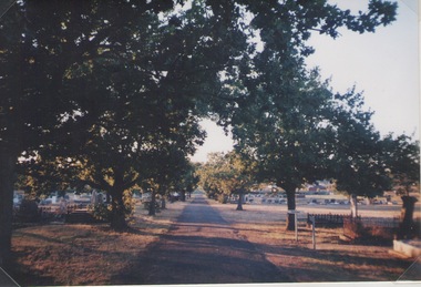 Sunbury Family History and Heritage Society Inc.
Photograph, Lydia Kenworth, Sunbury Cemetery, March 2001
The avenue of trees is along the main pathway of the old section of the Sunbury Cemetery. In 1862 the cemetery in Sunbury was laid out in Christian denominational sections. There were other sections set aside for paupers, heathens and pagans. Over the years the size of the cemetery has increased to keep pace with the growth of Sunbury's population.Sunbury Cemetery is one of the oldest cemeteries in the local area.A non-digital coloured photograph of an avenue of trees in a cemetery. The photograph is one of a collection of images that was entered in a photograph competition organised by the former Sunbury & District Heritage Association in March 2001.cemeteries, sunbury, sunbury cemetery -
 Whitehorse Historical Society Inc.
Artwork, other - Ink Line Drawing, Margaret Picken, 14 Calypso Crt., Forest Hill, 1994
A property illustration by Margaret Picken Commissioned by the real estate agency Woodards Blackburn for the purpose of advertising 14 Calypso Crt., Forest Hill This property is listed as having sold for $220,000 in 1994. Made by using Rotring ‘Rapidigraph’ drafting pens with Rotring ink on Rapidigraph polyester drafting film, double matte. Trained as a cartographic draftsman within the mining industry, Margaret Picken is an artist who worked producing property illustrations for real estate agencies in eastern suburbs of Victoria from 1983-2005. Retiring from the industry as technological changes favored coloured photography over illustrations, and commissioning companies over sole contractors.This artwork is of Historical Significance as a record of local domestic architecture.A black ink line drawing on drafters film by Margaret Picken, of 14 Calypso Crt., Forest Hill of a two story house with a double garage in the background. A flat roofed two story house with garage. On the left is the driveway, and on the right a front lawn with garden beds and trees. There are two hole punch holes along the top edge.14 Calypso Crt., Forest Hill Margaret Picken -94 Woodards - B/Burnwhitehorse historical society, schwerkolt cottage, housing, architecture, margaret picken, house, garden, forest hill -
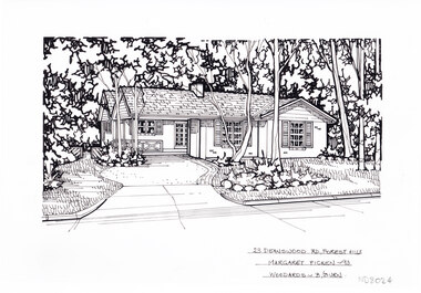 Whitehorse Historical Society Inc.
Artwork, other - Ink Line Drawing, Margaret Picken, 23 Deanswood Rd., Forest Hill, 1993
A property illustration by Margaret Picken Commissioned by the real estate agency Woodards Blackburn for the purpose of advertising 23 Deanswood Rd., Forest Hill This property is listed as having sold for $215,000 in 1993 Made by using Rotring ‘Rapidigraph’ drafting pens with Rotring ink on Rapidigraph polyester drafting film, double matte. Trained as a cartographic draftsman within the mining industry, Margaret Picken is an artist who worked producing property illustrations for real estate agencies in eastern suburbs of Victoria from 1983-2005. Retiring from the industry as technological changes favored coloured photography over illustrations, and commissioning companies over sole contractors.This artwork is of Historical Significance as a record of local domestic architecture.A black ink line drawing on drafters film by Margaret Picken, of 23 Deanswood Rd., Forest Hill. In the background a single story brick house with porch surrounded by trees, a driveway on the left leading to the house. In the foreground on the right is a front lawn with five trees. There are two hole punch holes along the top edge.23 Deanswood Rd., Forest Hill Margaret Picken -93 Woodards B/Burnwhitehorse historical society, schwerkolt cottage, housing, architecture, margaret picken, house, garden, forest hill