Showing 287 items
matching location plan
-
 Federation University Historical Collection
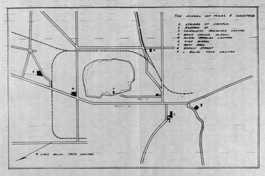
Plan, School of Mines and Industries: Location of buildings, Ballarat
... and Industries: Location of buildings, Ballarat Plan Plan ...Printed map showing Ballarat School of Mines locations.ballarat school of mines, plan, ballarat, lake wendouree -
 Ringwood and District Historical Society
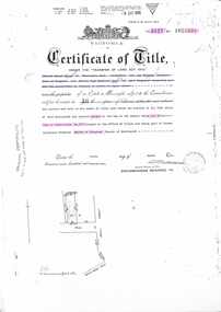
Document - Transfer of Land Act, Certificate of Title Vol 5127 Fol 1025238 including Ringwood Masonic Hall
Photocopied Certificate of Title Vol 5127 Fol 1025238 dated 9th March, 1926. Ernest Albert Milne (orchardist) and Jay Wilkins (builder) of Ringwood and Ernest Hugh Emmanuel Hann (carpenter) of East Ringwood are now proprietors as tenants in common in equal shares, Lot 30 on Plan of Subdivision No. 5577, part of Crown Allotment 19, Parish of Ringwood. Location map includes Aird Street, Pratt Street, Whitehorse Road. Subsequent Proprietors Transfers & Mortgate details include: Herman Pump and Frank Kenworthy of Ringwood and Albert Raymond of Collins Street Melbourne, trustees for the time being of the Loyal Ringwood Lodge No. 6724 of the MUIOOF Victoria Friendly Society - 26 June 1936, Holeproof Limited of 204 Sydney Road Brunswick, proprietor by transfer on 18th February, 1947, (*) Ringwood Masonic Hall Company Limited of 173 Whitehorse Road Ringwood, proprietor by transfer on 14th June, 1950, City Mutual Life Assurance Society Limited registered 1st March, 1965, ANZ Banking Group Limited, registered 10 June, 1981 & Discharged 3 June, 1982, Mayor Councillors and Citizens of the City of Ringwood registered as proprietors 6th July, 1982. (*During WWII, Holeproof had been renting the hall where they manufactured socks.) -
 Ringwood and District Historical Society
Map, Plan of Country Lands in the Parishes of Nunawading Ringwood and Scoresby - circa 1855
Blueprint copy of Survey Map detailing original Selectors' names and property locations. List of Parish map references including property bearings, distances in Links, and markings on trees. Descriptive remarks include areas marked "Farmer's Common", "Poor soil thickly/moderately timbered with stringy bark", and location of water and firewood reserves."Surveyed and plotted by N.M. Bickford, Superintendant of Mr. Hodgkinson's Field Party". "The land comprised in this survey is of inferior quality, moderately undulating, and thickly wooded. It is watered by Dandenong Creek and Deep Creek." Inset map showing location of (*proposed) cemetery on southern corner of Lillydale Road from Melbourne and Sawmill Road, later Mount Dandenong Road. (*Cemetery did not eventuate.) -
 Ringwood and District Historical Society
Map, Plan of the Parish of Warrandyte County of Evelyn - 1841
Blueprint copy of Survey Map W27 detailing original Selectors' names and property locations between Yarra Yarra River (Warrandyte) and Mullum Mullum Creek (Ringwood). List of Parish map references including property bearings, distances in Links, and markings on trees. Pound Bend area of Warrandyte marked as Reserve For Aborigines. Descriptive remarks include areas marked "scrubby, flat, sandy soil". Several other references faded and illegible.(Map) by T.H. Nutt Feb 3 1841. -
 Ringwood and District Historical Society
Document, Collection of copies of Maps relating to Wieland Houses and Properties (most undated), plus Document entitle Brian Pump's Orchard and House Locations, 25/2/2008
Collection of A4 photocopies of maps and plans, some with yellow highlighting, showing locations of Wieland properties and house including sub-divisions. Mostly in Heathmont but also Scoresby Most pages are undated and do not have original sources Document 28054 entitled Brian Pump's Orchard and House Locations has notes with maps of various houses with numbers corresponding to those on the included maps and also to those in 28054-003 document -
 City of Moorabbin Historical Society (Operating the Box Cottage Museum)
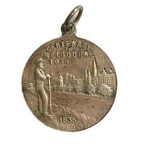
Badge - Centenary of Melbourne, c. 1935-35
White metal medal issued to commemorate Melbourne’s centenary 1934-35. This medal was given out to Victorian school children; 325,600 white metal medals were struck. The medal references Portland, the location of Victoria’s first settlement. The Henty brothers, entrepreneur farmers and whalers, established the state’s first permanent European settlement in Portland in 1834. Melbourne was established the following year by a party of settlers led by John Batman. In 1934, as Melbourne planned to celebrate the centenary of European settlement, it seemed to some that there was little to celebrate. The financial strains of the depression, unemployment and the scandal of the city’s slums all undercut claims of unbridled progress. Perhaps because of such troubles, the organisers of the centenary celebrations tried doubly hard to be positive. The themes of the celebrations were conservative, reflecting the desire of some Melburnians for security in troubled times. The widely promoted image of the ‘Garden City’ and ‘Queen City of the South’ emphasised the idea of Melbourne as a very British city. White metal badgeCentenary of Melbournemelbourne centenary, victorian school children -
 Flagstaff Hill Maritime Museum and Village
Plaque - Commemorative, circa 1928
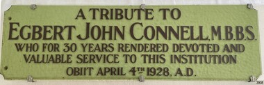
This commemorative plaque refers to the religiously themed window situated in the western (weather) wall of the St. Nicholas Mission to Seamen’s Church building in the Flagstaff Hill Maritime Village. It was crafted circa 1928. ABOUT THE WINDOW The window, to which this plaque belongs was once known as the Dr Connell Memorial Window, which was a feature of an external wall adjacent to the Women’s Children’s Wards of Warrnambool Hospital. Honorary Doctors had played a significant role in the operation of the hospital between the years 1900 to 1939. One of these doctors was Dr. Connell, who passed away in 1928. A paragraph in the book ‘A History of the Warrnambool Base Hospital’ by Forth and Yule describes the role of the Honorary Doctors - “At the start of the period the senior-part time medical officer was replaced by the junior resident medical officer and control of beds and the right to operate were given to the honorary medical officers...and these men dominated the Warrnambool medical world in the years before the Second World War.” Dr. Connell leased ‘Ambleside’, 192 Koroit Street, in the early 20th century, following Dr Teed who had previously run his medical practice there. In 1914 Dr Connell purchased the property and continued his private practice there until his death in 1928. He also took a prominent part in hospital work, both as physician and surgeon, and often acted as spokesmen for the Honorary Doctors. According to colleague Dr. Horace Holmes’ subsequent notes, it was after the close of the First World War, and the following years of the world-wide pneumonic influenza epidemic, that Dr. Connell himself contracted pneumonia and died. His family and friends then recognised his work by gifting the memorial window in his honour to the Hospital. By the mid-1970s the old wards at the hospital had been replaced and there was no obvious place for the window. Discussions between the previous and past Hospital managers, the Anglican Diocese, and Flagstaff Hill Planning Board, led to its installation in its present position in St Nicholas Seamen’s Church. It was installed without the bottom section of stained glass, which was inscribed as a memorial to Dr. Connell. St NICHOLAS SEAMEN’S CHURCH, Anglican Church Flagstaff Hill’s Mission to Seamen was opened in 1981. Its conception was partly motivated by the offer of Stained Glass Memorial Windows from the local Warrnambool and District Base Hospital, which was undergoing multi-storey development in the late 1960’s and early 1970’s. The Manager/Secretary at the time was keen to see the historical windows installed in an appropriate location. The chapel was designed by a local architectural draftsman in conjunction with members of the Planning Board of Flagstaff Hill, and built by Mr Leon Habel. The vision of the designers included the hope that the church be used for formal worship such as weddings and funeral, and for multi-denominational special services such as War commemorations. The design is based on the ‘Mission to Seamen’ buildings in both Portland and Port Melbourne. These types of buildings were often erected to house social and worshipful activities for seamen. The materials used in the building include sandstone recycled from nineteenth-century buildings demolished in Warrnambool and American slate tiles retrieved from the 1908 wreck of the FALLS OF HALLADALE. Most of the chapel furnishings came from the Williamstown Missions to Seamen, which was consecrated in 1946 but later decommissioned. These artefacts range from the altar cloth to the hymn board and include a visually stunning round stained glass widow called ‘Christ Guiding the Helmsman’. However the provenance of this particular artefact, large western window, is local.This plaque is significant because of its association with stained glass memorial window is of local, historical and social significance, linking local history and heritage with one of Warrnambool's doctors, Dr. Egbert John Connell (d. 1928), who gave 30 years of dedicated, medical service to the local citizens.Plaque, opaque, pale green glass rectangle mounted on white timber board and held in place with six decorative silver coloured clasps. Five rows of printed, capitalised text are fixed on the top surface. The plaque is companion to the commemorative, stained glass window installed in the St. Nicholas Mission to Seamen's Church at Flagstaff Hill. (The window was previously known locally as the Dr. Connell Memorial Window.)"A TRIBUTE TO / EGBERT JOHN CONNELL, M.B.B.S. / WHO FOR 30 YEARS RENDERED DEVOTED AND / VALUABLE SERVICE TO THIS INSTITUTION / OBIIT APRIL 4th 1928, A.D."flagstaff hill, warrnambool, shipwrecked coast, flagstaff hill maritime museum, maritime museum, shipwreck coast, flagstaff hill maritime village, great ocean road, chapel window, stained glass window, warrnambool and district base hospital, st nicholas mission to seamen’s church, williamstown mission to seamen, dr egbert connell, ambleside warrnambool, leon habel builder, falls of halladale slate, memorial window, commemorative window, dr connell, commemorative plaque, plaque, edgar mcconnell -
 Flagstaff Hill Maritime Museum and Village
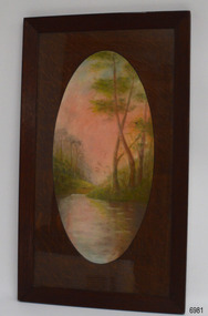
Drawing - Pastel Picture, W.R. Angus (Dr. William Roy Angus), 1925
This large pastel drawing was created by Dr W.R. Angus in 1925, the year after he graduated as a doctor in South Australia. In 1926 Dr Angus was appointed as Medical Assistant to Dr Thomas Francis Ryan, in Nhill, Victoria, where he extended his experiences in radiology and pharmacy. Eventually, in 1939, he and his wife Gladys moved to Warrnambool, Victoria, with their children. The drawing is part of the W.R. Angus Collection, which includes another of the doctor’s pastel drawings and a box of used pastels. The picture was framed by W.H. Rogers & Co. of North Terrace, Adelaide. The business also framed maps and plans. This pastel drawing is locally significant for being the work of Warrnambool doctor, W.R. Angus. It is part of the W.R. Angus Collection, which is significant for still being located at the site it is connected with, Doctor Angus being the last Port Medical Officer in Warrnambool. The collection of medical instruments and other equipment is culturally significant, being a historical example of medicine, administration, household equipment and clothing from late 19th to mid-20th century. Dr Angus assisted Dr Tom Ryan, a pioneer in the use of X-rays and in ocular surgery. The collection includes Army objects, which are examples of items issued to Doctors and Surgeons in the Medical Services of the Australian Army in World War 2. It also includes household items used by Dr Angus and his family from the 1920s in various locations including Warrnambool, together creating an understanding of the furnishing of an early to mid-20th century home.Pastel drawing behind glass in a rectangular wooden frame with an unusual oval wooden matt. The subject is a scene with a pink-tinted sky reflected in a river running between the foot of two hills with trees. The picture was created and signed by W R Angus in 1925. The back is covered in brown paper and has a mounting wire. Inscriptions are on the picture and the back. A remnant of the framer’s label is attached. The picture is part of the W.R. Angus Collection. Signature and date; “W.R.A. / 1925” Printed on label remnant; “—Rogers & Co. / - ORIA STREET / - way Station, North Terrace / “THE CORRECT FRAMERS” / -lise in Map and Plan Mounting / PHONE 5437”flagstaff hill, warrnambool, maritime village, maritime museum, shipwreck coast, great ocean road, drawing, pastel drawing, pastel drawing by w.r. angus 1925, rogers & co., w.h. rogers & co., correct framers, w.r. angus collection -
 Bendigo Historical Society Inc.
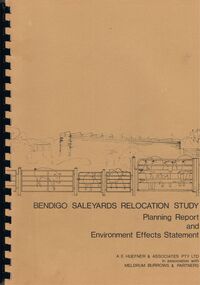
Book - BENDIGO SALEYARDS COLLECTION: BENDIGO SALEYARDS RELOCATION STUDY - PLANNING REPORT AND ENVIRONMENT
Bendigo Saleyards Relocation Study - Planning Report and Environment Effects Statement for the City of Bendigo by A E Huefner & Associates Pty Ltd in association with Meldrum Burrows & Partners. Book has a light brown cover with black plastic binder spine. Green and yellow pages separate some sections. The front cover has a sketch of a stock transport with a pig, sheep and cattle behind gates. Contents include: Introduction, Summary, Recapitulation on the Feasibility Report which includes The Need for Action, the Site and Existing Uses Adjacent to the Site, The Proposal which includes Concept, Project Description, Components, Siting of Facilities, Land Clearing, Earthworks, Darainage, Buildings and Structures, Roads and Pavements, Services, Landscaping, Soil Profile and Construction Programme. Invironmental Effects which include Visual Impact Dust, Odours, Effluent, Effluent Treatment System, Traffic, Artificial Lighting, Noise, Operational Failures and Nature Conservation Effects. Statutory Planning Considerations which includes Zoning Controls and Suggested Procedure for Initiating I.D.O. Amendment. Appendices are: A.- Copy of Tit;e, B - Soil Investigation, C - Acoustic Assessment and D - Suggested Draft Amendment to Shire of Marong I.D.O. Contains a photo of the area - View of the Site, looking South and a number of drawings. Copies of various Council Reports referring to the Saleyards Relocation Project. It has a bright yellow cover and a hard plastic type spine. Mentioned in the reports is the cost to bring the old saleyards up to standard and list of improvements. Reports are as at 16th July, 1984. Mustard coloured book with plastic spine titled Bendigo Saleyards Relocation Study Feasibility Report by Meldrum Burrows & Partners in association with A E Huefner & Associates Pty Ltd and Acil Australia Pty Ltd dated September, 1983. Items mentioned are: Introduction, Summary, Background, Role in Livestock Marketing for the Bendigo Saleyards (Acil Australia Pty. Ltd., Saleyard Relocation: Strategic Considerations, Financial Implications and Conclusion. Appendix 1: Estimation of Livestock Population in Catchment Area. Drawings in Fig 1 Existing Bendigo Saleyards and Surrounding Land Uses, Fig 2 Catchment Area for Bendigo Saleyards 1983, Fig 4.1 Estimated Sheep Populatiuon in Catchment Area 1976 - 77 to 1981 - 82, Fig 4.2 Estimated Cattle Population in Catchment area 1976 -77 to 1981 -82, Fig 3 Possible Saleyard Relocation Areas, Fig 4, Directions from which access to possible Saleyard Locations would be obtained - Estimated percentage of sheep to cattle stock, Fig 5 Possible Saleyard Locations - Northern Area, Fig 6 Possible Locations of Saleyards - Inner West, Fig 7 Possible Locations of Saleyards - Outer West. Considerations were made as to renovate the existing saleyards or to move them elsewhere. Effluent, transport and stock movement, and condition of the yards were a problem.bendigo, council, cattle markets, bendigo saleyards collection - bendigo saleyards relocation study - planning report and environment effects statement, a e huefner & associates pty ltd, meldrum burrows & partners, city of bendigo, state electricity commission, mal styles, bendigo college of advanced education, n j fieldew, pryce goodale & duncan pty ltd, p b swift, shire of marong -
 Bendigo Historical Society Inc.
Document - PLAN SHOWING THE VARIOUS CLAIMS ON THE NEW CHUM VICTORIA , ST MUNGO & DEVONSHIRE REEFS BENDIGO
Map of mines - calico scroll showing locations of various claims .printed in black ink on off-white Calico with turned wooden ends on scroll -missing one wooden end , some stains and creasing / Plan showing the various Claims on the New Chum Victoria , St Mungo & Devonshire reefs BendigoW Holmes , printer & lithographer , Sandhurstorganization, mining, industrial, w holmes , printer & lithographer , sandhurst/new cum , victoria st mungo & devonshire reefs bendigo -
 Bendigo Historical Society Inc.
Document - RAE'S CRUSHING BATTERY - THE RICH VICTORIA HILL & ITS HISTORICAL ASSOCIATIONS
The first five pages are photocopies of photos:- 2 of Rae's Crushing Works; Victoria Quartz on Victoria Hill, Ironbark; Looking North from Old Chum Hill to the Victoria Hill; Victoria Hill - from Rae's Open Cut. Introduction covers location of buildings and mines. Mentioned are:- North Old Chum Mine, Ballerstedt's First Open-cut, Quartz Veins (Spurs), rock formations pitching North, Prospecting shafts 1929, Concrete dam, Engine beds of Lansells Big 180 Mine, Lansells Big 180 Shaft, twenty stampers crushing battery, Lansell's Cleopatra Needle type chimney, Victoria Quartz Mine, Victoria Quartz dams, Rae's Open-cut, Quartz once roasted here to an intense heat, Anticlinal Arch New Chum Line, small primitive tunnels, Prospecting tunnels, Floyd's small 5 head crushing battery, Great Central Victoria (Midway) Shaft, Great Central Victoria engine-bed, Ballerstedt's small 24 yard claim, The Humboldt, Adventure ground, The Advance, Luffsman & Sterry's Claim, A round shaft. Small piece of paper with 'Notes on Victoria Hill complete.document, gold, rae's crushing battery, rae's crushing battery, rae's crushing works, victoria quartz mine, from old chum hill, victoria hill from rae's open cut, ironbark, hercules & energetic, midway, wittscheibe, great central victoria, mr & mrs conroy, central nell gwynne, gold mines hotel, john brown knitwear factory, new chum & victoria, rotary club of bendigo south, north old chum, ballerstedt's first open-cut, lansell's big 180 shaft, cleopatra needle type chimney, a roberts & sons, mr e j dunn, h harkness & sons, eureka extd, new chum railway, pearl, inrush of water at victoria quartz, floyd's small 5 head crushing battery, great central victoria (midway), ballertedt's small 24 yard claim, humboldt, humboldt, great central victoria, victoria hill, bendigo & vicinity 1895 p51, j n macartney 1st edition 1871, bendigo goldfield registry 1871, plan of new chum line, mr rae anderson, annals of bendigo obituary 1904, bendigo advertiser, b m l records mines dept, patterson's goldfields of victoria, dickers mining record 23/11/1861, australian mining standard special edition 1/6/1899 p40, bendigo mines ltd, chinese joss house, fortuna, the victoria goldfield 1851 to 1954, the victoria hill 1854 to 1949 -
 Bendigo Historical Society Inc.
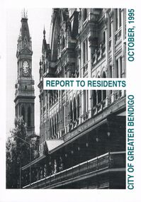
Book - BOOKLET: ''REPORT TO RESIDENTS CITY OF GREATER BENDIGO, OCTOBER 1995''
Front cover is a photo of The Shamrock Hotel. 52 paged booklet - ''Report to Residents - City of Greater Bendigo, October 1995''. Table of Contents; Commissioners; Chief Executive Officer; Council meetings; Office location and hours; ''One Telephone Number''; Committees; Ward boundaries; Elections; Customer services; Rural services; Economic development; Bendigo Tourism Board; Bendigo Trust; Events Bendigo; Capital works 1995/96; Major projects; Discovery; Bendigo Regional Arts Centre; local laws; Fire prevention; Aged and disability services; Children and family services; Environmental health; Recreation and leisure; Parks and gardens; Planning and building; Waste management; Library services; Bendigo Leisureland; Rates; Budget for 1995/96; Index. Contains some photographs and map of proposed 7 internal Wards for the City of Greater Bendigo.Richard Cambridge Printers Bendigo.bendigo, council, report, maxine crouch, maurie sharkey, perer ross-edwards, peter seamer, hadley sides, richard morriss, bernard smith, annie galvin child care centre, bendigo regional art centre, rosalind park, budget 1995/96. bendigo health care services. -
 Bendigo Historical Society Inc.
Document - DEBORAH REEF PROJECT ENVIRONMENT EFFECTS STATEMENT
Two page document. On top, first page ' Bendigo Mining N.L., Deborah Reef Project, Environment Effects Statement, Summary Brochure'. Poppet head on top LH corner of document. A map of central Bendigo is drawn on page 1 and shows the location of the proposed processing plant near the Airport. Further maps on page 2 and 3 show the North Deborah Mine Site, the pipeline route and the airfield site. The summary brochure provides an outline of the material contained in the Environment Effects Statement and proposed planning scheme amendments upon which, the Deborah Reef Project will be assessed. Page four lists the issues that impact on this submission: planning and land use; socio economic environment; traffic; discharges to air; water management; explosives storage and handling; subsidence; heritage; flora and fauna and landscape and visual assessment. The 16th March, 1989, is the date given for submissions to be lodged in regard to this project.Bendigo Mining N.Lbendigo, mining, deborah reef project -
Bendigo Historical Society Inc.
Map - NEW CHUM & VICTORIA LINES OF REEF - PLAN OF NEW CHUM & VICTORIA LINES OF REEF
Two pages of a Plan of New Chum & Victoria Lines of Reef, compiled by G. W. Hart. Taken from J. N. Macartney's G'Fields Registry for 1871. Plan shows leases from High Street to California Gully. Location of the Manchester Arms, British & American Hotel and the Quartz Miners Arms are shown. Townships of Long Gully and Ironbark are shown.map, goldfields, new chum & victoria lines of reef, plan of new chum & victoria lines of reef, victoria catharine g m coy, thornton & co, extd victoria reef g m co, ural tribute compy, nil desperandum compy, koch, north victoria g m co, danger hill coy, north endeavour coy, wheadon & co, pilot co, north energetic co, energetic compy, endeavour company, hercules co, victoria gold mines compy, iron duke g m co, golden fleece united, ballerstedt, alfred co, confidence co, prince alfred co, canterbury co, advance co, wells, humboldt co, adventure co, try me well, sterry & co, gibbs & ballerstedt, handy andy, wells?, south adventure co, w rae, victoria reef quartz m co, myra co, jackson, wybrants, burrows & sterry, new chum & victoria tribute, old chum co, ballerstedt, lazarus, watson, koch & hildebrand, lansell & hunt, dennis, abe lincoln co, bonati & co, ellesmere co, moore late menzies, british co, british tribute co, garibaldi, c c co, new chum trib, dobson & co, young chum co, little chum co, old chum co, new chum trib, little chum trib, g w hart, j n macartney's g'fields registry for 1871, manchester arms, british & american, quartz miners arms -
Bendigo Historical Society Inc.
Map - HUSTLER'S ROYAL RESERVE NO 2 MINE - PLAN OF THE HUSTLER'S ROYAL RESERVE NO 2 MINE
Plan of the Hustler's Royal Reserve No 2 Mine Bulletin No 33, Plate No V. Plan shows the Hustler's Royal Reserve No 2 (Main Shaft), Hustler's Royal Reserve No 2 (Park Shaft.), the Royal Hustler's, the Imperial Hustler's and the Extended Hustler's Freehold on the Hustler's Line of Reefs. Also mentioned is the Lightning Hill Line of Reefs. Map shows some of the levels, approximate boundary of lease and the boundary of Lease No 8892 and 8897. There are also street names and the locations of jail, lagoons, Post Office, Rosalind Park and the State School, High School and Continuation School. Geological Survey of Victoria emblem. H. Herman Director, W. Dickson, Secretary of Mines and The Hon. J. Drysdale Brown MLC, Minister of Mines. Signed by zh Whitdan, Underground Survey Office, Bendigo, September 1913.mining, parish map, hustler's royal reserve no 2 mine, plan of the hustler's royal reserve no 2 mine, hustler's royal reserve no 2 (main shaft), hustler's royal reserve no 2 (park shaft), royal hustler's, imperial hustler's, extended hustler's freehold, geological survey of victoria, h herman, w dickson, the hon j drysdale brown, h whitdan, hustler's line of reefs, lightning hill line of reefs -
Bendigo Historical Society Inc.
Document - HERCULES AND ENERGETIC MINES - NOTES ON THE HERCULES AND ENERGETIC MINES
Four typed copies of notes on the Hercules and Energetic Mines. Notes include Location, depth of shafts, plant and machinery, Early History and Prominence. Reference: Mines Dept Special Edition Australian Mining Standard 1.6.1899, Mines Dept Booklet Bendigo Goldfield 1936, Mines Dept Annual and Quarterly Reports, Annals of Bendigo Mining Sections 1876 - 1921, A Richardson, The Bendigo Goldfield Registry J N Macartney 1.3.1871, Mines Dept Bulletin No 30 h Herman 1914, Bendigo Amalgamated Goldfields Coy Financial Reports 1920.mine, gold, hercules and energetic mines, hercules and energetic mines, notes on the hercules and energetic mines, the hercules, the energetic, the north energetic, the victoria pilot, plan of leases of 1870, bendigo amalgamated goldfields company, sheepshead line, wheat owl, central blue, big blue, mines dept special edition australian mining standard 1.6.1899, mines dept booklet bendigo goldfield 1936, mines dept annual and quarterly reports, annals of bendigo mining sections 1876 - 1921, a richardson, the bendigo goldfield registry j n macartney 1.3.1871, mines dept bulletin no 30 h herman 1914, bendigo amalgamated goldfields coy financial reports 1920 -
Bendigo Historical Society Inc.
Document - LANSELL'S BIG 180 MINE - CONDENSED HISTORICAL RECORD OF LANSELL'S BIG 180 MINE
Two handwritten and three typed copies of a Condensed Historical Record of Lansell's Big 180 Mine on the New Chum Line of Reef. Notes include location, shaft, first worked, size of lease, plant, engine house, boiler rooms, mullock heap, early history, Prominent, best gold, underground connections, pressurised hot water, diamond drill bores and a table with depths and the increase in temperature with the depth (in Fahr).document, gold, lansell's big 180 mine, lansell's big 180 mine, condensed historical record of lansell's big 180 mine, wittscheibe, ballerstadt, ernst mueller, theodore ballerstadt, george lansell, north old chum, victoria quartz, mines dept special edition 'australian mining standard' 1/6/1899, mines dept booklet 'bendigo goldfield' 1936, quarterly reports, lansell's 180 mine 'transverse sections, annals of bendigo mining sections, a richardson's observations from old photographs and measurements of mining plans, measurements taked from caleb thomas' report mines dept 1875, 'report on observation of underground temperature at bendigo' james stirling government geologist 1899, a richardson -
Bendigo Historical Society Inc.
Map - LANSELL'S BIG 180 MINE - LOCALITY OF LANSELL'S NO 180 SHAFT
Buff coloured photocopy of the location of Lansell's No 180 Shaft and showing the positions of Underground Workings near the intersection of Lily St and Alley St. Also mentioned are the North Old Chum Shaft and the New Chum and Victoria Co Shaft. Luffman Brothers has been written in in pen and initialled A R. Printed at the bottom is: Surveyed by E. T. Brown, under the direction of A. W. Howitt, Secretary for Mines for the - (the rest is cut off).map, bendigo, mining plan, lansell's big 180 mine, locality of lansell's no 180 shaft, north old chum co shaft, new chum and victoria co shaft, luffman brothers, e t brown, a w howitt -
 Bendigo Historical Society Inc.
Map - STRUGNELL COLLECTION: HUSTLER'S LINE OF REEFS, September 1913
Map, Hustler's Line of Reefs, Hustler's Reef & Hustler's Reef No.1 Mines Plan.Plate No. XV1.(16) Sheet 2 .Bulletin No 33 Signed H.A.Whitelaw.Underground Survey Office, Bendigo, September,1913. Included is the emblem of the Geological Survey of Victoria. Drawing shows a plan view of reefs and shaft locations .Underground Survey Office, Bendigomap, bendigo, hustler's reef & hustler's reef 1 -
 Bendigo Historical Society Inc.
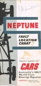
Map - J W SWATTON COLLECTION: MAPS
Seven maps of various sizes. Map of the City of Ballarat, Victoria, Road Condition Map of Victoria including Melbourne-Cairns & Melbourne-Adelaide, Neptune Fault Location Chart, Grampians District Map, Racv Tour Planning Map Showing Road Conditions for Victoria, NSW and Queensland and Mt Macedon & District. Two of the maps have J W swatton & J Swatton written on them.j w swatton collection, racv, mobil, neptune, a r blair, j ewins & sons pty ltd, berry anderson & co -
 Bendigo Historical Society Inc.
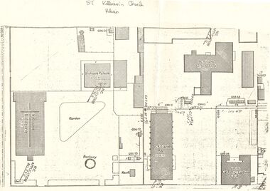
Document - PLAN OF THE AREA SURROUNDING: ST. KILIAN'S CHURCH
Plan of area surrounding St. Kilian's Church showing location of church, Bishop's Palace, and Vault, position of the Bell,. St. Kilians Girls School, St. Kilians Hall and the Catholic Ladies Club building. Plan is over stamped in a number of places with ''H.C. Application No 765'' and appears to have spot heights and indication of slope in two places (''I in 60''). No indication on plan of scale of plan. No date.church, history, st. kilian's catholic church, bendigo, bishops palace, ladies club building, st kilian's hall. -
Port Melbourne Historical & Preservation Society
Plan - Berthing of HMY Britannia, HMAS Vampire/Torrens, Port of Melbourne Authority
... Promenade Deck location. Plan Berthing of HMY Britannia, HMAS ...Plan re berthing of HMY Britannia and HMAS Vampire/Torrens, and Royal Promenade Deck location.Traffic direction indicators in red, green, orange inks. Barriers indicated in red ink. Vampire crossed out, Torrens written above in pencil. Lifts and some areas of Waiting Hall marked in orange felt-tip.piers and wharves - station pier, royal visits and occasions, melbourne harbor trust - port of melbourne authority -
Port Melbourne Historical & Preservation Society
Photograph - Centenary Bridge prior to complete demolition, Pat Grainger, 1988 - 1991
11 colour photographs taken from various locations of the Centenary Bridge prior to complete demolition in 1991 One B&W photo of the staircase on the West side of the Centenary Bridgecentenary bridge, demolitions, built environment, town planning - proposals shelved - bayside -
Port Melbourne Historical & Preservation Society
Book - Borough of Sandridge, Officers of the Council, Asphalt Pavement Accounts, 1877 - 1960
Asphalt Pavement Accounts book 1877- 1960. 'Borough of Sandridge' printed at top of pages. Columns record person liable for cost, location, measurement, cost of pavement and when paid. Path construction plan 1959 attached. Loose items are copies of notices sent to owner c1960s.'Asphalt Pavements Accounts' is embossed on the spine. The title given on the cover includes the words 'important records'engineering - roads streets lanes and footpaths, local government - town of port melbourne, local government - city of port melbourne, local government - borough of port melbourne, arthur victor heath, town clerks -
 Port Melbourne Historical & Preservation Society
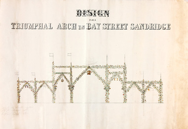
Plan - Triumphal Arch, Bay Street, Sandridge, Borough of Sandridge, 1867
Drawn for the Council Committee for reception of Prince Alfred Oct 1867Design for triumphal arches in Bay Street, Sandridge (with measurements for Fountain Inn, Bridge Street and Liardet Street locations) probably 1867 - visit of Prince AlfredMeasurements noted in pencil.royal visits and occasions, celebrations fetes and exhibitions, prince alfred, bay street -
 Port Melbourne Historical & Preservation Society
Photograph - Construction of Bank Houses, Jack GOULD
From a box of photographs in Nancy U'REN's papers used during research for her thesis, The Early Growth and Development of Sandridge (1976) and/or her book with Noel TURNBULL, A History of Port Melbourne (1983). Comparing the form and location of the doors and windows with plans for the various types of Bank Houses, the semi-detached building on the right appears to be Type 5. Jack GOULD probably created this from an earlier photograph.Black and white photograph across vacant ground to the construction of some Bank Houses.bank houses, garden city, nancy u'ren nee morris -
Port Melbourne Historical & Preservation Society
Plan - Map and aerial photo of Port Melbourne, c. 1990
Notations made as a result of conversations Anne had in the early 1990s with an elderly male resident of Port Melbourne.Map and Aerial photo of Port Melbourne with handwritten annotations detailing the location of various buildings, trotting tracks, etc which previously existed in Port Melbourne (recollections only).fishermans bend -
 Bendigo Historical Society Inc.
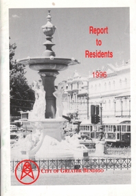
Book - BOOKLET: REPORT TO RESIDENTS CITY OF GREATER BENDIGO, 1996
Front cover is a photo of Alexandra Fountain. 52 paged booklet - ''Report to Residents - City of Greater Bendigo, 1995. Table of Contents; The Mayor; Chief Executive Officer; Council meetings; Office location and hours; ''One Telephone Number''; Locations of functions and business; Units; Organisation Structure; Advisory Committee; Municipal Boundaries; Customer services; Economic development; Bendigo Tourism; Bendigo Trust; Events Bendigo; Capital works 1996/97; Bendigo Regional Arts Centre; Local laws; Aged and disability services; Children and family services; Environmental health; Recreation and leisure; Parks and gardens; Planning and building; Waste management in Bendigo; Library services; Rates; Budget for 1996/97; The budget at a glance; Index.bendigo, council, report -
 Bendigo Historical Society Inc.
Document - Various writings by John Ellison
Writings on various topics. Some are glued inside a notebook. Two others are on loose pages. The notebook has a view of a lake/river with several small villages on the banks. location unknown. Topics are: "The Australian Aboriginals", ' The Great Pastland Movement", Problem of Urban Planning" and "the Plea of Youth".On the cover and on the first page a stamp: L.J. Ellison A.I.M.A.australian aborigines, pastoralist movement, urban planning -
NMIT (Northern Melbourne Institute of TAFE)
Video recordings: Instructional NMCOT and NMIT 1980s
U-Matic Video recordings (Master tapes) mostly dated in the 1980s. Alphabetically: A house of all trades [No date] (14 min). An Introduction to floor managing An introduction to floor managing. Architrave: running the mould. Solid plastering. [No date] (17 min). Boom spray calibration (turf management). [No date] (6 min). Drafting. Module C51 Step no 4.(footwear) (1987) [No time] (Edit master) Fibrous plastering (1988) (Duration 11.00) Firm foundations: presenting a case for finance (21 min) Flux cored arc welding. Roof plumbing: fitting outlet. Friction in engineering (20 min). Grafting and budding techniques. (1986) (Duration 10.00) Horticultural courses at Collingwood College of TAFE. [No date] (10 min). Making a hand made thread. [No date] [No time] Making a hand-made thread Manual metal arc welding [No date] (24 min). Master saddlery; stitching: 1 saddle, 2 back. Microphones and their use in location sound recording [No date] [No time] Microphones and their uses in location sound recording Mold cutting [No date] [No time] Plain sailing: a film about business planning (20 min). Potentiometers, Part 1. (1983)(16 min). Preparation of artwork for video tape production (1977)(162 min). Preparation of instructional video tapes (1977)(12 min). Roof plumbing: fixing eaves cutters: Part 1 – fixing methods. [no time] Saddlery: hand stitching Safe saddle making. (1985) [No time] Solid plastering/Setting in Plaster and lime (1987) (Duration 10.00) (Edit master) Special electronic effects in video production. [No date] [No time] Splitting a stone using plugs and feathers [No date, possibly 1987] (Duration 9.40) (Master edit) The necessary art; videotape lighting: practical tips. (1974)(15 min). Tiling a staircase (1987) (Duration 25.00) (master edit) Water resistant board (W.R. Board): What is a word processor (26 min). WR Board northern metropolitan college of tafe, handbooks, nmit