Showing 346 items matching "mapping"
-
 Bendigo Military Museum
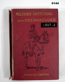
Book - Military Sketching and Reconnaissance, Muckler Ferryman, Royal Military College, Sandhurst, UK, 1903
British Military method of compiling field sheets for mapping purposesRed Hard covered book, rider and horse on cover, 203 pages, 17 chapters, 4 Appendices, 57 Illustrations.Lieut -Col AF Mockler - Ferryman, Late professor of Military Topography, Royal Military College, Sandhurstroyal australian survey corps, rasvy, fortuna, army survey regiment, army svy regt, asr -
 Bendigo Historical Society Inc.
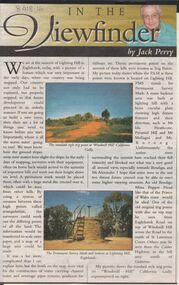
Newspaper - JACK PERRY COLLECTION: NEWSPAPER LIGHTNING HILL
Newspaper article, Bendigo Weekly, on Lightning Hill and Permanent Survey Markers, their importance in mapping, drainage and sewerage planning. Marker on Lightning Hill shows distance and direction to Mr. Ida Heathcote, Pyramid Hill, Mt. Moliagul and Mt. Korong.person, individual, jack perry, lightning hill, permanent survey markers, windmill hill -
 Bendigo Military Museum
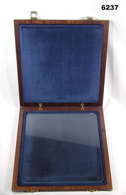
Article - Aerial photography Diapositive Filter Plate, circa 1960
Aerial photography glass plate filter used in the production of aerial photography for mappingWooden box, lacquered, hinges and clasps, blue felt lined, glass plateroyal australian survey corps, rasvy, fortuna, army survey regiment, army svy regt, asr -
 Stawell Historical Society Inc
Book - Country Fire Authority, Region 17 Rural Directory 2nd Edition 1990
Maps for use of C.F.A.Bound Plastic Cover over pale green soft cover with CFA Logo. green & white zebra crossing.Country Fire Authority Region17 Rural Directory 2nd Edition 1990. Published by the C.F.A. Mapping Association Inc. Sold by same, at R 17 H.Q. 119 Firebrace Street Horsham Firebrace 3400. -
 Montmorency–Eltham RSL Sub Branch
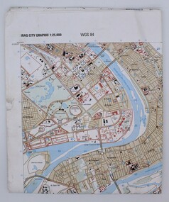
Map, Baghdad
Prepared and published by the National Imagery and Mapping Agency Copyright 2003 by the United States GovernmentPaper, coloured The map is of Baghdad Iraq city Graphic 1:25,000. WGS 84 Edition 11- NIMA Series K941 Sheet 4 Map information as of 2001map -
 Bendigo Military Museum
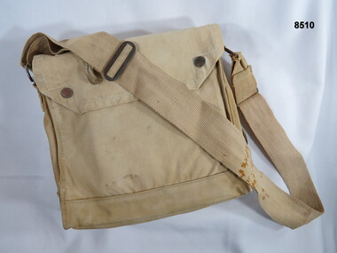
Equipment - MAP CASE, Unknown
Khaki carry bag carried over the shoulder, possibly used as a mapping carry case or survey bag. The top flap is secured by press stud closures, the bottom of the bag has small brass ventilators. The bag is fitted with an over the shoulder carry strap.passchendaele barracks trust, equipment, bag, map case -
 Stawell Historical Society Inc
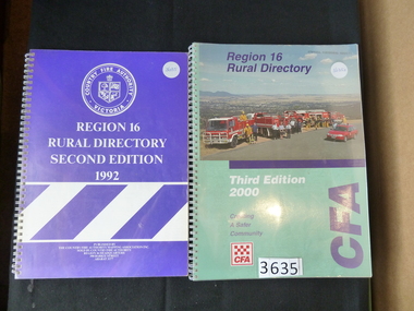
Book, Country Fire Authority, Region 16 Rural Directory, Second Edition 1992 - Country Fire Authority - Previously Cat No 3635, 1992
A book of maps of region 16 for use by the CFA in bushfires Clear Plastic cover with wire spiral binding, over pruple paper with CFA Logo and White Stripes in the lower halfRegion 16 Rural Directory Second Edition 1992 Published by The Country Fire Authority Mapping Association INc. Sold by Country Fore Authority Regio 16 Headquarters 390 Barkly Street Ararat 3377stawell map -
 Department of Energy, Environment and Climate Action
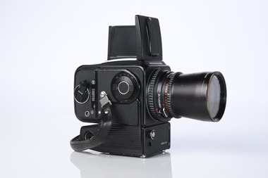
Hasselblad aerial camera
Aerial photos were used to make maps of forest types, timber resources, to survey logging areas and regeneration, to mark boundaries of public land and new plantations, to identify new roads and tracks, as well as for fire suppression. Infrared film was sometimes used to monitor insect and disease attack. The images needed to sharp, with high contrast, and in a large format (most were printed in B&W on 9-inch by 9-inch glossy photographic paper) with at least a 60% overlap to enable stereoscopic viewing and with a 20-30% side lap to allow for aircraft drift. Preferably, the photo scale was close to the final map scale avoid to problems when enlarging and to reduce distortion. Something was needed to supplement the very expensive and infrequent large-area photography programs. From the mid-1960s Victorian foresters began experimenting with small format 70mm and 35mm cameras which proved simple, practical, cheap and flexible. It was found that any SLR camera could be used provided it had a good quality lens and fast shutter speed (preferably down to 1/1000 second). Motorised cameras with a large film capacity had obvious advantages and were essential when access to the camera was not possible during flight. It is also essential for the shutter to operate at low temperatures and those lubricated with silicones were recommended. Components of a typical FCV Divisional Office system included – A Hasselblad or Vinten 70 mm format aerial camera with a focal plane shutter which could be electrically operated. Interchangeable lenses to allow for different photo scales and flying heights. Several large film magazines, which were loaded in a darkroom, each with a capacity of 100 feet or approximately 500 frames. A remote control for the camera in single-shot mode or automatic firing at selected intervals of 2 to 50 seconds. It also needed a frame counter. A light aircraft was modified with an internal mounting for the camera to keep it level and steady. Often a hole was cut through the floor for the lens. The aircraft also needed an inbuilt 12 Volt DC battery to operate the motorised camera shutter. The front passenger seat was generally removed to improve access to the camera. An Aldis drift sight was also fitted. This might be likened to an inverted periscope and is used to determine drift, to facilitate accurate navigation along flight lines and to determine the exposure interval for stereoscopic overlap. This item is kept at Traralgon.Hasselblad 500 ELM camera with 70mm lens, film pack, motor drive and battery In 1964 Hasselblad started production of a motorized camera, the 500 EL The EL/M is a modified version of the EL, "M" means modified, "EL" electric. Perhaps the most famous use of the Hasselblad camera was during the Apollo program missions when man first landed on the Moon. Almost all of the still photographs taken during these missions used modified Hasselblad cameras. forests commission victoria (fcv), forest measurement, surveying, mapping -
 Department of Energy, Environment and Climate Action
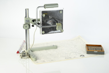
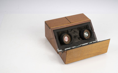
Zeiss Sketchmaster
The Zeiss Sketchmaster was used to transfer information from aerial photographs onto scale maps. The operator views the aerial photograph and the map simultaneously and manually traces detail from the photograph onto the map. It utilises the principle of the camera lucida, patented in 1806. Various lens combinations were used on a to adjust for scale and then “rubber sheet” the image to line up topographic features like streams and roads. The photo information was then laboriously transferred using a light table onto large A0 paper maps or translucent drafting film. The maps were later hand coloured with either Derwent pencils or delicately painted with Pelikan ink wash. This item is kept at Erica.Zeiss Sketchmaster. c1970s. Includes adjustable stand, various lens in sperate box, adjustable light, map holder and magnetsforests commission victoria (fcv), forest measurement, mapping, surveying -
 Bendigo Military Museum
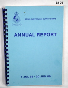
Administrative record - Royal Australian Survey Corps Annual Report 1 Jul 85 - 30 Jun 86, DSvy - A, RASvy Corps, Report on activities 1 Jul 85 - 30 Jun 86, Circa 1986
The status of RASVY activities (for the dates shown) in field surveying, mapping and charting is given in this report and is shown pictorially in the Annexes to the reportBlue book, plastic ring binder, Map and Chart production 85-86, Annexes graphically depicting map productionroyal australian survey corps, rasvy, fortuna, army survey regiment, army svy regt, asr -
 Bendigo Military Museum
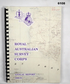
Administrative record - Royal Australian Survey Corps - Annual Report 1990/91, Royal Australian Survey Corps, Late 1991
Annual Report detailing the status of Australian mapping, charting and geodesy for the period 1 Jul 90 - 30 Jun 91A4 soft covered book, glossy paper pages and plastic pockets containing maps. Plastic ring bindingTop right hand corner "2IC Tech WO"royal australian survey corps, rasvy, fortuna, army survey regiment, army svy regt, asr -
 Bendigo Military Museum
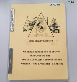
Administrative record - An Error Budget for Products produced by the RASvy Corps, Major Edward J Wright US Army Corps of Engineers, 1988
This document is an analysis determining the positional accuracy (size of errors) within Topographic Mapping Products produced by the Royal Australian Survey Corps.A yellow carboard covered booklet, 2 x "ARNOS" fasteners, Army Survey Regiment Unit emblem designed by SSgt Denis MacCarthy.royal australian survey corps, rasvy, fortuna, army survey regiment, army svy regt, asr -
 Bendigo Military Museum
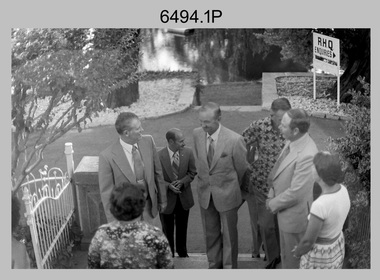
Photograph - MAJGEN Nicholson - Director DMA to the Army Survey Regiment, Bendigo, 1980
This set of nine black and white photographs were taken during the visit to the Army Survey Regiment, Bendigo by the Director of the USA’s Defense Mapping Agency –MAJGEN William L. Nicholson III, on the 7th of February 1980. He was accompanied by US Army COL W.P. ‘Pinky' Holmes and an unidentified Major from the USAF. It is not known if their wives or partners were in attendance.This set of nine black and white photographs were taken during the visit to the Army Survey Regiment, Bendigo by the Director of the USA’s Defense Mapping Agency –MAJGEN William L. Nicholson III, on the 7th of February 1980. The photographs are on 35mm negative film and scanned at 96 dpi. They are part of the Army Survey Regiment’s Collection. .1) - Photo, black & white, 1980. L to R: unidentified civilian (facing away), MAJGEN William L. Nicholson III, MAJ Sam Schwartz US Exchange, CO LTCOL Bob Skitch, D-SVY COL NRJ Hillier, MAJ Don Swiney MBE, Mrs Glen Swiney. .2) - Photo, black & white, 1980. L to R: unidentified civilian & Mrs Glen Swiney, (facing away), MAJGEN William L. Nicholson III, CO LTCOL Bob Skitch, unidentified civilian (facing away). .3) - Photo, black & white, 1980. L to R: unidentified visiting USA officer, MAJ Sam Schwartz US Exchange. .4) - Photo, black & white, 1980. L to R: CAPT Peter Ralston, CAPT Dennis Puniard, CAPT Bob Roche, MAJGEN William L. Nicholson III, CO LTCOL Bob Skitch. .5) - Photo, black & white, 1980. L to R: unidentified (x4), MAJ Sam Schwartz US Exchange, unidentified, CAPT Bob Roche, unidentified (x3), MAJ Paddy Strunks, unidentified, Mrs Glen Swiney, unidentified civilian (facing away)., CAPT Don Maskew, unidentified civilian. .6) - Photo, black & white, 1980. L to R: MAJ Peter Eddy, D-SVY COL NRJ Hillier, CO LTCOL Bob Skitch, MAJGEN William L. Nicholson III, remainder unidentified. .7) - Photo, black & white, 1980. L to R: MAJGEN William L. Nicholson III, CO LTCOL Bob Skitch. .8) - Photo, black & white, 1980. L to R: ADJT CAPT John Harrison, unidentified civilian. .9) - Photo, black & white, 1980. L to R: Mrs Glen Swiney, unidentified civilians (x2).No personnel or civilians are identifiedroyal australian survey corps, rasvy, army survey regiment, army svy regt, fortuna, asr -
 Bendigo Military Museum
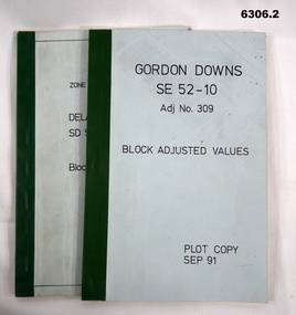
Administrative record - Report on the Block Adjustment of the Gordon Downs and Delemere 1:250,000 Maps, Army Survey Regiment, 1 Sep 1991, .2 Jan 1988
All mapping produced at this time were produced using Aerial Photography. These booklets contain the adjusted mathematical solution to joining this group of photographs together..1 Blue covered booklet with green tape binding. Block adjusted values for Gordon Downs SE 52-10 1:250 000 map Adjustment number 309 Sep 1991 .2 Blue covered booklet with green tape binding. Block adjusted values for Delamere SD 52-16 1:250 000 map Adjustment number 272 Jan 1988royal australian survey corps, rasvy, fortuna, army survey regiment, army svy regt, asr -
University of Melbourne, Burnley Campus Archives
Plan, Alton-Hascombe Feature Survey, c. 1990
1 tracing paper and 2 paper copies of plan by Department of Conservation, Forests and Lands, Division of Survey and Mapping, of adjoining gardens Alton and Hascombe at Mount Macedon, Victoria. Scale 1:1000. Plan of properties includes buildings, gardens and paddocks. 1 copy has significant buildings coloured.feature survey, mount macedon, gardens, alton, hascombe -
 Bendigo Military Museum
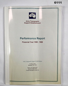
Administrative record - Army Topographic Support Establishment: Performance Report Financial Year 1998 - 1999, 13 Jul 1999
A Report showing numerous charts of production objectives for all types of mapping production conducted by the Army Topographic Support Establishment in the Financial year 1998 - 1999A4 size, clear plastic front cover, white plastic back cover, bound with tape. 16 loose pages, 8 x coloured pages showing production rates, 7 x pages roduction summary and RAAF C-130E Hercules replacement programme, 1 x page summarising production.royal australian survey corps, rasvy, fortuna, army survey regiment, army svy regt, asr -
 Department of Energy, Environment and Climate Action
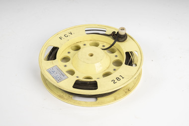
FCV measuring band
Used for measuring distances in the forest. Steel bands (out of tradition were called the chain) were created around 1890. They replaced the traditional Gunter chain. The band could be repaired by soldering slip-on joiners and than and recalibrating.Steel measuring band (50m) on plastic reel with winding handleFCV 281forests commission victoria (fcv), assessment, forest measurement, surveying, mapping -
 Department of Energy, Environment and Climate Action
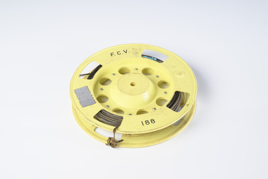
FCV measuring band
Used for measuring distances in the forest. Steel bands (out of tradition were called the chain) were created around 1890. They replaced the traditional Gunter chain. The band could be repaired by soldering slip-on joiners and than and recalibrating.Steel measuring band (50m) on plastic reel with winding handle missingFCV 188forests commission victoria (fcv), assessment, forest measurement, surveying, mapping -
 Department of Energy, Environment and Climate Action
FCV measuring band
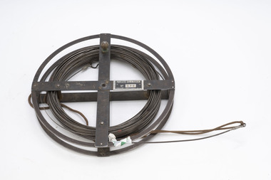
Used for measuring distances in the forest. Steel bands (out of tradition were called the chain) were created around 1890. They replaced the traditional Gunter chain. The band could be repaired by soldering slip-on joiners and than and recalibrating.Steel measuring band (1 chain - 66 feet) on metal reelFCV 075forests commission victoria (fcv), assessment, forest measurement, surveying, mapping -
 Department of Energy, Environment and Climate Action
Data modem
used to transfer field measurement data to Melbourne for processingMoore Reed Acoustic couplerForests Commission Victoria Assessmentforests commission victoria (fcv), communications, surveying, mapping, assessment -
 Bendigo Military Museum
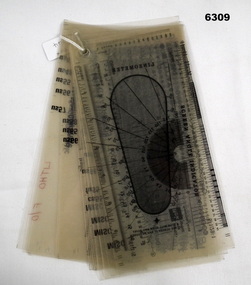
Equipment - Font -Type Style and Point Size Guide, Royal Australian Survey Corps, Circa 1991
Also referenced in the Collections Victoria Bendigo RSL item 6300 Lithographic Squadron Equipment Handbook 1991. Commonly called a type styles guide, used for the selection and editing of text styles and size in mapping.20 Sheets of 21 x 11 cm clear photographic film (connected in the Top left hand corner) depicting various Type Font Styles and Point Sizes including special characters. It also contains a digital Type gauge, a linometer and a screen angle Indicator. royal australian survey corps, rasvy, fortuna, army survey regiment, army svy regt, asr -
 Bayside Gallery - Bayside City Council Art & Heritage Collection
Photograph, Department of Crown Lands and Survey, Victoria, Melbourne Project: Brighton, 1976
The Department of Crown Lands and Survey (1857-1983) was responsible for the administration of survey and mapping and the sale, occupation and management of crown land throughout its existence. This aerial photograph shows parts of Brighton and was taken on 1 December 1976brighton, department of crown lands and survey, aerial photograph, bayside, port phillip bay, map, cartographic material, melbourne project 1976, brighton yacht club, middle brighton baths, north road, st kilda street, new street -
 Bayside Gallery - Bayside City Council Art & Heritage Collection
Photograph, Department of Crown Lands and Survey, Victoria, Melbourne Project: Brighton and Elwood, 1976
The Department of Crown Lands and Survey (1857-1983) was responsible for the administration of survey and mapping and the sale, occupation and management of crown land throughout its existence. This aerial photograph shows parts of Brighton and Elwood and was taken on 1 December 1976brighton, elwood, department of crown lands and survey, aerial photograph, elsternwick park, point ormond, north road, ormond esplanade, st kilda street, glen huntly road, bayside, port phillip bay, map, cartographic material, melbourne project 1976 -
 Bayside Gallery - Bayside City Council Art & Heritage Collection
Photograph, Department of Crown Lands and Survey, Victoria, Melbourne Project: Brighton and Hampton, 1976
The Department of Crown Lands and Survey (1857-1983) was responsible for the administration of survey and mapping and the sale, occupation and management of crown land throughout its existence. This aerial photograph shows parts of Brighton and Hampton and was taken on 1 December 1976. brighton, department of crown lands and survey, aerial photograph, bayside, port phillip bay, map, cartographic material, melbourne project 1976, brighton yacht club, middle brighton baths, hampton, green point, brighton beach, south road, the esplanade, hampton street -
 Bendigo Military Museum
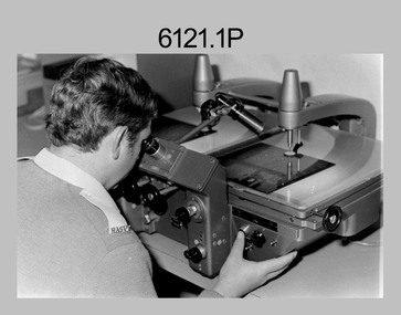
photograph - Aerotriangulation Production – Army Survey Regiment, Fortuna, Bendigo, c1980
This collection of five photos was most likely taken in 1980. Wild PUG4 point transfer devices were used by technicians in Air Survey Squadron to stereoscopically view the photography containing the survey control points and the mapping aerial photography. The Control points were transferred from the control photography to the mapping diapositives of aerial photography by drilling their locations into the photographic emulsion. The Zeiss (Jena) Stecometer analytic stereocomparator for air photography was introduced at Air Survey Squadron in 1963. Aerotriangulation production was expedited using computers for analytical photogrammetric processes. The technician accurately measured between pass, tie, and survey control points on aerial photographs.Air Survey Squadron Aerotriangulation Section - Army Survey Regiment, Bendigo. c1980. This is a set of five photographs of Air Survey Squadron personnel operating aerotriangulation equipment at the Army Survey Regiment at Fortuna, Bendigo, c1980. Photographs .1P to .4P are on 35mm negative film and were scanned at 96 dpi. Black and white photo .5P is on photographic paper and was scanned at 300 dpi. They are part of the Army Survey Regiment’s Collection. .1) - Photo, black & white, c1980, Wild PUG4 point transfer device, unidentified technician. .2) - Photo, black & white, c1980, Wild PUG4 point transfer device, unidentified technician. .3) - Photo, black & white, c1980, Wild PUG4 point transfer device, unidentified technician. .4) - Photo, black & white, c1980, Zeiss (Jena) Stecometer, unidentified technician. .5) - Photo, black & white, c1980, Zeiss (Jena) Stecometer..1P to .5P No personnel are identified.royal australian survey corps, rasvy, army survey regiment, army svy regt, fortuna, asr, air survey, aerotrig -
 Bendigo Military Museum
Document - Contingency Support Capability - Army Topographic Support Establishment (ATSE) Implementation, Army Survey Regiment, Bendigo, Apr - Jun 1995
.1 The Minute details that the Army Survey Regiment is maintain a contingency production capability until ATSE is operational. .2 The Minute details the Data Aquisition Squadron requirements during the Implementation to ATSE. .3 The Minute details the Hardware, Software, Personnel and skills required during Implementation to ATSE. .4 The Instruction details that the non-core mapping, charting and geodetic (MC&G) activities of the Army Survey Regiment and 4 Fd Svy Sqn were tested under the Commercial Support Program (CSP) process resulting in the decision to award the contract for the provision of non-core mapping services to the ADF to the Preferred In-House Option (PIHO). .1 Contingency Support Capability - Army Topographic Support Establishment (ATSE) Implementation 26 Apr 95 (11 x A4 pages) .2 Data Acquisition Squadron (DAS) Contingency Support Capability - Army Topographic Support Establishment (ATSE) Implementation Apr 95 (4 x A4 Pages) .3 Contingency Support Capability - Army Topographic Support Establishment (ATSE) Implementation 28 Apr 95 (9 x A4 pages) .4 Directorate of Military Survey - Army Instruction for Implementation of the Army Topographic Support Establishment (ATSE) Jun 95 (10 x A4 pages)royal australian survey corps, rasvy, fortuna, army survey regiment, army svy regt, asr, atse -
 Bayside Gallery - Bayside City Council Art & Heritage Collection
Photograph, Department of Crown Lands and Survey, Victoria, Melbourne Project: Brighton, Hampton, Sandringham, 1976
The Department of Crown Lands and Survey (1857-1983) was responsible for the administration of survey and mapping and the sale, occupation and management of crown land throughout its existence. This aerial photograph shows parts of Brighton, Hampton and Sandringham and was taken on 1 December 1976brighton, department of crown lands and survey, aerial photograph, bayside, port phillip bay, map, cartographic material, hampton, sandringham, green point, sandringham yacht club, south road, beach road, hampton street, melbourne project 1976 -
 Bayside Gallery - Bayside City Council Art & Heritage Collection
Photograph, Department of Crown Lands and Survey, Victoria, Brighton, Elwood and Elsternwick, c. 1965-71
The Department of Crown Lands and Survey (1857-1983) was responsible for the administration of survey and mapping and the sale, occupation and management of crown land throughout its existence. This aerial photograph shows parts of Brighton, Elwood and Elsternwick and was taken circa 1965-71.brighton, department of crown lands and survey, aerial photograph, bayside, port phillip bay, map, cartographic material, elwood, elsternwick, elsternwick park, elwood tram depot, elwood pier, new street, glen huntly road, st kilda street, nepean highway -
 Bayside Gallery - Bayside City Council Art & Heritage Collection
Photograph, Department of Crown Lands and Survey, Victoria, Brighton, Brighton East and Bentleigh, c. 1965-71
The Department of Crown Lands and Survey (1857-1983) was responsible for the administration of survey and mapping and the sale, occupation and management of crown land throughout its existence. This aerial photograph shows parts of Brighton and Brighton East and was taken circa 1965-71.brighton, department of crown lands and survey, aerial photograph, bayside, port phillip bay, map, cartographic material, brighton east, dendy park, dendy street, centre road, nepean highway, south road, brighton golf course, golf -
 Bendigo Military Museum
Administrative record - Report on Mechanism Ltd Precision Aneroid Barometer Type M1847 - WO2 Lambert (RASvy) August 1960, WO2 Lambert RASvy, August 1960
This is a Report on the Mechanism Ltd Precision Aneroid Barometer Type M1847 by WO2 Lambert (RASvy) August 1960 under the direction of the Chief Instructor at the School of Military Survey Balcombe Victoria was to determine the accuracy of the instrument for calculating heights for mapping purposes.A 6 x Foolscap sized page report that is stapled and four hole punched.. The report contains typed text, diagrams and tabular results on the fold out annex.Number "54" in top RH cornerroyal australian survey corps, rasvy, fortuna, army survey regiment, army svy regt, asr, school of military survey, balcombe