Showing 1699 items matching "maps and documents"
-
 Bendigo Military Museum
Administrative record - International Map of the World (IMW) 1:1 Million Scale - H Ureta, Circa 1964, MR H Ereta, Post 1964
This document records the history of the International Map of the World (IMW) at 1:1Million Scale. Mr H. Ereta, Chief of the Cartographic Section of the United Nations Department of Economic Development and Social Affairs gave a lecture on the IMW and described the history and development of the map series in post 1964. This document is a copy of that lecture. 7 x Foolscap pages of typed text, stapled and two hole punched, Paper is dis-coloured.royal australian survey corps, rasvy, fortuna, army survey regiment, army svy regt, asr, imw -
 Bendigo Military Museum
Administrative record - DIGO Map Library and Repromat Review 2004, Geospatial Analysis Centre, Bendigo, 25 Oct 2004
Prior to the digital revolution the only medium by which cartographic information could be reproduced and distributed on mass was via printed media. The final negatives (repromat) used to produce the printed products were the culmination of a complex cartographic process and were therefore carefully preserved and stored. Preservation of the so-called final negatives enabled subsequent reprinting with minimal cartographic intervention. Since the arrival of the Land Headquarters Cartographic Company at Fortuna in 1942 the repromat for all products produced by the Australian Survey Corps were carefully stored. With the disbandment of the Army Survey Regiment in 1996 the Defence Imagery and Geospatial Organisation (DIGO) inherited that repromat archive. It was immanent that the support for film based printing was ending so on 25 October 2004 a review was required to determine the way ahead for the repromat and paper maps stored in the DIGO Map Libraries. Most of these maps were produced by the Royal Australian Survey Corps. This report is the result of that review. The report recommends the disposal of the repromat and the retention of single map copies. A4 plastic covered report, plastic clip bound, front page clear and rear page red. 9 x page document about the future of repromat and map printing.royal australian survey corps, rasvy, fortuna, army survey regiment, army svy regt, asr -
 4th/19th Prince of Wales's Light Horse Regiment Unit History Room
Letter, 13 Oct 1924
A typed letter from the Australian War Memorial to Col M W S Bourchier CMG, DSO, requesting papers, documents or maps of war interest that he may have.bourchier, australian war memorial -
Glenelg Shire Council Cultural Collection
Administrative record - Progress Report of Portland Harbour - Royal Commission of Victoria, 1925
Retrieved from the files of the former Maritime Discovery Centre Manager at the Portland Information Centre (A copy of this report is listed in the manifest from the Port of Portland when collection was offered in 1995)Front: Capt. J W Brown -inkport of portland -
 Bendigo Historical Society Inc.
Document - MCCOLL, RANKIN AND STANISTREET COLLECTION: MAPS AND SECTIONS KALGOORLIE, 1929
Document: MCCOLL, RANKIN AND STANISTREET: green cover book Bulletin 94, Maps and Sections to accompany report on the geology and ore deposits of the Boulder Belt, Kalgoorlie. Plages IV - XV11.Government printer, Perthorganization, business, kalgoorlie, mccoll, rankin and stanistreet, kalgoorlie, maps and sections -
Tatura Irrigation & Wartime Camps Museum
Book, Albrecht Dümling, The Vanished Musicians, Jewish Refugees in Australia, 2016
Tells the stories of Jewish refugees brought to Australia, particularly those on the Prison Ship "Dunera". Emphasis on musicians.Many of the musicians were interned in camps in the Tatura Group of Internment Camps.Blue soft covered book with photos of musicians playing their instruments on front cover. There are maps, photographs, sketches of musical programmes and copies of official documents required by the refugees. 2nd copyExile Studies, Vol 14. ISBN 978-3-03-431951-3 jewish musicians - australia, jewish refugees - australia, albrecht dumling, jewish musicians, jewish refugees -
 Bendigo Military Museum
Administrative record - Royal Australian Survey Corps Planning Conference 1972 - Standard of Compilation sheets by Army Survey Regiment, Army Survey Regiment, Bendigo, 03.10.1972
This booklet was prepared for the Royal Australian Survey Corps Planning Conference 1972 by the Army Survey Regiment held at Fortuna Bendigo. It was intended to provide a trouble shooting guide for personnel engaged in the production of map compilation sheets. See also item Number 6517 "Standard of Compilation Sheets" by LtCol DR Ridge (RASvy)26 x A4 page document containing typed text diagrams and copied map extracts, photocopies and Oza film. Item is four hole puched and is held together by an ARNOS Fastenerroyal australian survey corps, rasvy, fortuna, army survey regiment, army svy regt, asr -
 Bendigo Historical Society Inc.
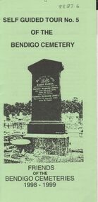
Document - BENDIGO CEMETERIES COLLECTION: SELF GUIDED TOUR NO. 5 DOCUMENT
BHS CollectionGreen trifold document: Self guided tour No. 5 of the Bendigo Cemetery, Friends of the Bendigo Cemeteries 1998 - 1999' Map of cemetery with numbered graves. Theme 'Heritage all around us'Friends of the Bendigo Cemetery 1998bendigo, cemetery, bendigo cemetery tour -
 Bendigo Historical Society Inc.
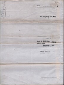
Document - MCCOLL, RANKIN AND STANISTREET COLLECTION: CENTRAL NAPOLEON GOLD MINING CO. N.L, 5th July 1948
Document: Letter from McColl, Rankin & Stanistreet to the Central Napoleon Gold Mining Co N.L. regarding a Residence Licence from Mr R.Roberts, the letter is asking the company whether they have any objections to the request, Land in question is marked on the map contained within the mining lease for document no 2205.704a.organization, business, industry - mining, mccoll rankin & stanistreet, mining, gold mining, central nepoleon, r roberts -
 Bendigo Historical Society Inc.
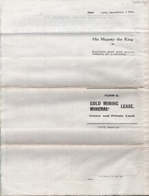
Document - MCCOLL, RANKIN AND STANISTREET COLLECTION: NAPOLEON REEF GOLD MINING CO. N.L, 22 August 1950
Document: 5 Page legal document with map of lease area, Lease No. 11273 Bendigo, Vol.331, Fol. 36453, 15 year lease from 12 December 1949, in vicinity of Inglis, Harvey & Curnow Streets, Signed by Dallas Brooks, Gov of Victoria & J.J. Stanistreet, Mine Manager.organization, business, industrial - mining, mccoll rankin & stanistreet, mining, gold mining, napoleon reef -
 Greensborough Historical Society
Map, Map of Greensborough - Jessop's Real Estate, 1930c
This map of Greensborough hung in the office of Cec Jessop's Real Estate office corner Main and Grimshaw Street. Includes a word document listing street name changes from the original map to today, according to Norm Colvin.This map was saved from the building when the business closed.Canvas roll-up map with timber rails top and bottom.greensborough - maps, cecil jessop, greensborough street names -
 Bendigo Military Museum
Print - PRINT, FRAMED, WW1, Reader's Digest (Australia) Pty Limited, 2015
From information Book - "Readers Digest'/ Gallipoli/ 25th April 1915 - 9th January 1916/ Centenary Commemorative Prints." Collection of 20 prints. Refer Cat No. 7300.Framed print. Print - colour print on paper. MAP ANZAC - map scale 1:10,000 elevations in feet. Depicts the line of Australian and New Zealand Front Trenches. Intended as a working document. Frame - Black plastic framing with glass front and MDF board backing with adhered black paper.Details below print - in black ink. "GERALD R. CAMPBELL Anzac: Map of Gallipoli Peninsula, 1916"framed accessories, prints, ww1, gallipoli, centenary -
 Falls Creek Historical Society
Plan - Leases of part of Falls Creek Tourist Area
Bob (Herman) Hymans (a former member of the Royal Netherlands Navy was born in Bloemendaal, Holland on 30th September 1922. During World War II he fought against the Japanese in the Dutch East Indies (now Indonesia) and was imprisoned in Changi and on the Burma Railway. After gaining qualifications as a Ski Instructor, Bob arrived in Falls Creek in May 1950. Working as an Instructor and Supervisor at Bogong Lodge, Bob decided his future was in accommodation. He was successful in negotiating an indenture for land from the State Electricity Commission (SEC). It took Bob two years to build his Grande Coeur Chalet but, tragically, it was burned down in August 1961. Bob also built the first Chairlift in Australia. This was a single chairlift and the structure was built from wooden electricity poles. He was constantly full of new ideas and proposals for the village. Bob Hymans died on 7th May 2007. This Collection of documents and letters tells the story of Bob’s endeavours to develop Falls Creek into the ski village it is today. This map is significant because it documents boundaries of early leases in Falls Creek Tourist Area.This map is part of Bob Hymans documents. It is a large Surveyor's Plan of a section of the Falls Creek Tourist Area. It is endorsed by J Parker, Chief Surveyor of the State Electricity Commission of Victoria on 27-3-84. It shows streets, lot numbers and measurements. It was a compilation created from existing lease maps. Heading - PART OF FALLS CREEK TOURIST AREA PART OF CROWN ALLOTMENT 1 PARISH OF CARRUNO PART OF CROWN ALLOTMENT 1 PARISH OF DARBALANG COUNTY OF BOGONGmap of falls creek, falls creek leases, falls creek 1980s -
 Bendigo Historical Society Inc.
Document - MCCOLL, RANKIN AND STANISTREET COLLECTION: DEBORAH GOLD MINES NL GOLD MINING LEASE ON PRIVATE LAND, 1941
Document McColl, Rankin and Stanistreet: - 3 page lease document Deborah Gold Mines NL, with map., Lease adjoins Railway Reserve, Breen Street, Bendigo. Transferred to North Deborah Mining Company NL of Charing Cross, Bendigo on 9th. Oct. 1950. No. 11013, Vol 323, Fol 35696.organization, mining, gold mining lease documents, mccoll, rankin and stanistreet:, deborah gold mines nl, north deborah mining company nl, gold mining, lease document -
 Kew Historical Society Inc
Document - Urban Planning Document, City of Kew, City of Kew : Minimum Size of Allotment Required, 1945-1955
A document outlining the relevant by-laws produced by the City Of Kew to regulate the minimum size of allotments in Barkers Road, Burke Road, Cotham Road, Glenferrie Road and Studley Park Road, as well as in other streets more generally. The by-laws specify the size of allotments in which single unit dwellings, attached houses and maisonettes, and flats could be built. In the ‘main streets’ a minimum land area for single unit dwellings was 8,100 square feet, with an average frontage of 60’ and a depth of 135’. In other streets this was reduced to an overall size of 6,250 square feet, with an average dimensions of 50’ x 125’. In specifying the land area required by flats, different sizes were regulated for the construction of between two and six flats. Six flats at the time when the regulations were passed must have been the upper limit permitted. Understanding the size of land listed in imperial measurements can be a challenge. Within Australia, the so-called quarter acre block was approximately 11,000 square feet. Those specified in the by-laws would appear to be smaller. The document was pasted on the reverse of a subdivision plan in the collection.This is a rare (undated) document produced by the City of Kew defining how subdivision within the municipality should occur. The document was created to constrain unbridled speculation in subdivisions in the various parts of Kew and East Kew.Undated typed document, issued by the City of Kew (1921-1994) indicating the minimum size of allotment required in Barkers Road, Burke Road, Cotham Road, Glenferrie Road and Studley Park Road. The document is mounted on board and waterstained. It was presumably used by a real estate agent. [Formerly catalogued as MAP.0066].city of kew - by-laws and regulations, subdivisions - kew - studley park -
 Bendigo Historical Society Inc.
Document - ALBERT RICHARDSON COLLECTION: NEW CHUM RAILWAY MINE, GOLDEN SQUARE
Three-page typed document plus map. Document details location and history of the New Chum Railway Mine, Golden Square and includes: depth of shaft, size of lease, locality, poppet legs, winding engine, engine houses, crushing battery, best gold obtained, prominence, and total gold production and dividends. References provided. Document forms part of research referred to in Albert Richardson's paper 2264.70.bendigo, mining, new chum railway gold mine -
 Bendigo Historical Society Inc.
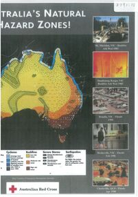
Document - Map outlining Australia's natural hazard zones
John Perry collection. Laminated document. Color. Map of Australia in the middle of document surrounded by 10 images of natural disasters that have occurred in Australia in Cairns, Darwin, Cleve, Northam, Central Queensland, Mt. Macedon, Dandenong Ranges, Benalla, Healesville, and Charleville. Legend demonstrates different types of natural disasters and zones in which they are more likely to occur. Has logo of Australian Red Cross at the bottom of document. map, tornado, cyclone, flood, drought, natural disasters -
 Orbost & District Historical Society
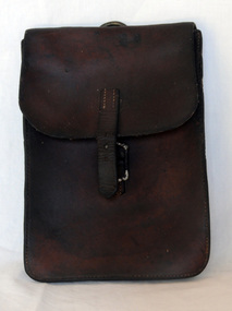
document bag, Early 20th century
A brown leather document/map bag. It is envelope style with a rusted silver coloured buckle. On the back is a silver coloured metal ring to attach to a saddle. The flap has a small strap to close the buckle.leather-case document-holder -
 Bendigo Historical Society Inc.
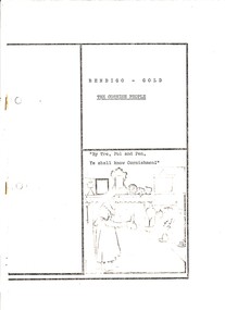
Book - THE CORNISH PEOPLE
The Cornish People - Helen Campbell. Brown manilla folder containing a black and white printed document of 25 pages entitled Bendigo - Gold The Cornish People. Contains narrative, photographs, illustrations & map.Helen Campbellbendigo, history, cornish, cornish history recipes cornish people in bendigo cornish names -
 Bendigo Historical Society Inc.
Document - INDENTURE, GOLD MINING LEASE 11081 CROWN AND HERBERT JACKSON LEED OF BENDIGO, MCCOLL, RANKIN AND STANISTREET COLLECTION, 21st September, 1940
Six page document plus map, dated 21st September 1940, between the Crown and Herbert Jackson Leed, for the land shown on the accompanying map 'indicated by yellow colour' Depths indicated on lease document. On map: Mining District of Bendigo, County of Bendigo, Parish of Sandhurst. No. 11081. Net Area 24 acres, 3 roods, 3 perches. Signed by Herbert Leed and ?Walsh, Warden Clerk, Bendigo. Map shows lease holding 11081 coloured yellow. Other leases: no's. 9882 11081, 11034, 11080. Streets: Fletcher Street, and Belle Vue Road. Gullies: Derwenters Mistake Bully and Pig Face Gully on lease 11081. Quarry Hill Recreation Reserve marked and some residential allotments. Water race indicated on map. On back of document: ; Deborah United Gold Mining Company No Liability of Charing Cross Bendigo is now the proprietor of the within described estate by transfer registered on 21st November 1940 and numbered 1795202.bendigo, mining, deborah united gold mine, herbert jackson leed, deborah united gold mining. major general sir winston joseph dugan -
 Peterborough History Group
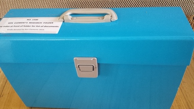
Document - Ken Clements Research Folder, 2014
A comprehensive collection of documents, maps, book extracts and newspaper articles pertaining to the history of Peterborough. Researched and arranged by Ken Clements.An extensively researched collection of information in various forms indexed and arranged chronologically, portraying the timeline of Peterborough from Pre white settlement to 2014.Indexed expanding document folder containing individually researched information collated and indexed by Ken Clements.peterborough 3270 -
 Bendigo Historical Society Inc.
Document - MCCOLL, RANKIN AND STANISTREET COLLECTION: ALICE PEEL GOLD MINING LEASE DOCUMENT, 8/7/1945
Document : McColl, Rankin and Stanistreet - gold mining lease document in name of Alice Peel, Executrix of Will of Edward Peel, deceased. 3 pages with map. No. 11198, Vol. 328., Fol. 36141. Lease crosses Houston Street, Quarry Hill. Transferred to South Deborah Gold Mines NL on 15/8/1946.organization, mining, south deborah gold mines nl, mccoll, rankin and stanistreet, alice peel, edward peel, gold mining lease, gold mining -
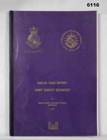 Bendigo Military Museum
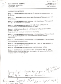
Administrative record - RASvy - Defense Mapping Agency Exchange Officer End of Tour Report MAJ D Bowen 1982, MAJ DH Bowen US Army Corps of Engineers, 3. 5. 1982
A 2 x year personnel exchange program existed between RASvy and the US Army Corps of Engineers. This is the End of Tour Report produced by David H Bowen, Major, Corps of Engineers, US Army Exchange Officer, Australia in 1982A4 Document, Plastic cover, Purple and gold, RASvy Badge emblem and Defense Mapping Agency Badge emblems in gold, 17 pages, 13 enclosures, black and white print, colour photos and mapsReport compiled by David H Bowen, Major, Corps of Engineers, US Army Exchange Officer, Australiaroyal australian survey corps, rasvy, fortuna, army survey regiment, army svy regt, asr -
Glenelg Shire Council Cultural Collection
Document - Shire of Portland Map and local attractions, Vanda Savill, n.d
Bowerbird Museum4 Page document produced by Vanda Savill. Front and back pages have hand written and illustrated descriptions of Shire of Portland, including attractions. Inside is a map of the Shire with towns and areas of interest highlighted. -
Bendigo Historical Society Inc.
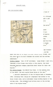
Document - HARRY BIGGS COLLECTION: MAP - BENDIGO
Document. Harry Biggs Collection. A very rough hand drawn map of Pall Mall area taking in Police Court, Survey Office, Dudley House, Stockade, Fire Brigade, Camp & commissioners Gully.place, building, public buildings, harry biggs collection, map, bendigo -
 Whitehorse Historical Society Inc.
Letter - Correspondence, East Burwood Reserve, 1993
Various documents relating to the establishment of East Burwood ReserveVarious documents relating to the establishment of East Burwood Reserve including acquisition of land, details, plans, locality map, news cuttings and photographs. Appears to be copy of Nunawading City Council File April 1993Various documents relating to the establishment of East Burwood Reserve sportsgrounds, east burwood reserve, soilleur (dr), hitchens, anna, blue moon fruit co-operative ltd., jacobson and logan, king family, central methodist mission, aussat, tally ho, sewart, bill -
Canterbury History Group
Document - Canterbury Mansions and Stables, 13/03/1991 12:00:00 AM
Photocopy of a document relating to the Draft Statement of Significance for Canterbury Mansions. Contains a short history of Canterbury, the role the hotel has played in that history, and descriptions of the interior and exterior. Includes many photographs and 2 mapscanterbury, canterbury mansions, canterbury club hotel, canterbury road, city of boroondara, historic buildings register, jacob lewis vines, malone family, temperance movement, wattle valley road, stables, outbuildings -
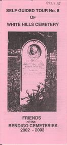 Bendigo Historical Society Inc.
Document - BENDIGO CEMETERIES COLLECTION: SELF GUIDED TOUR NO. 8 DOCUMENT
BHS CollectionPink document trifold. Self Guided Tour No. 8 of White Hills Cemetery, Friends of the Bendigo Cemeteries 2002 - 2003. Theme of tour 'Symbolism in White Hills Cemetery' Map with numbered grave sites.Friends of Bendigo Cemeteries 2002bendigo, cemetery, white hills cemetery tour -
 Bendigo Historical Society Inc.
Document - MCCOLL, RANKIN AND STANISTREET COLLECTION: DEBORAH GOLD MINES NL GOLD MINING LEASE DOC, 1941
Document: McColl, Rankin and Stanistreet: Gold Mining Lease Private Land, 11089 Bendigo on front of document., Deborah Gold Mines NL - 3 pages, with map. Lease adjoins Railway Reserve, Breen Street. Transferred to North Deborah Mining Company NL on 9th. October, 1950. No. 11089, Vol 326 Fol 35941.organization, mining, gold mining lease, mccoll, rankin and stanistreet:, deborah gold mines nl, north deborah mining company nl, gold mining, lease -
Glenelg Shire Council Cultural Collection
Plan - Glenelg Shire Council Plan 2004-2008, c. 2004
Glenelg Shire Council Plan 2004-2008.