Showing 467 items
matching mining site.
-
 Bendigo Historical Society Inc.
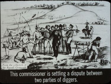
Slide - DIGGERS & MINING. THE GOLD LICENCE, c1850
... of mining sites, along with almost barren hills in the background... officer and a number of mining sites, along with almost barren ...Diggers & Mining. The gold licence. The Government Camp. Slide: This commissioner is settling a dispute between two parties of diggers. Slide also shows another officer and a number of mining sites, along with almost barren hills in the background. Markings: 8 994.LIF. 4. Used as a teaching aid.hanimounteducation, tertiary, goldfields -
 Ballarat Heritage Services
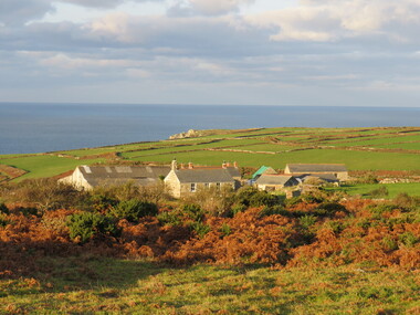
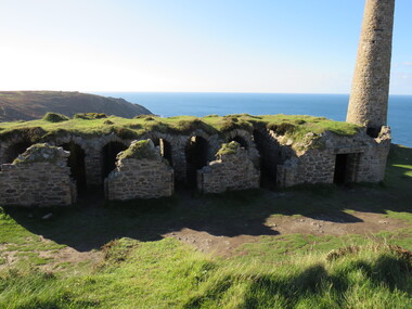
Photograph - Colour, Scene, St Just, Cornwall
... st just, mining, world heritage site, bendigo... Office goldfields st just, mining, world heritage site, bendigo ...st just, mining, world heritage site, bendigo -
 Bendigo Historical Society Inc.
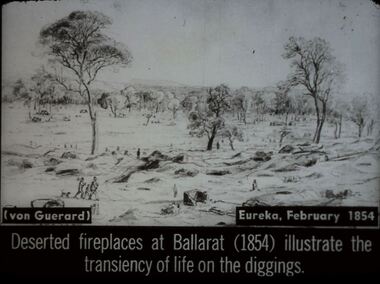
Slide - DIGGERS & MINING. DIGGERS AND MINERS, c1854
... the transiency of life on the diggings. Slide shows old mining site.... Slide shows old mining site with holes piles of dirt and fire ...Diggers & Mining. Diggers and miners. (von Guerard) Eureka, February, 1854. Deserted fireplaces at Ballarat (1854) illustrate the transiency of life on the diggings. Slide shows old mining site with holes piles of dirt and fire places. Only a few miners are left, some appear to be leaving. Markings: 37 994:LIF I. Used as a teaching aid.hanimounteducation, tertiary, goldfields -
 Myrtleford and District Historical Society
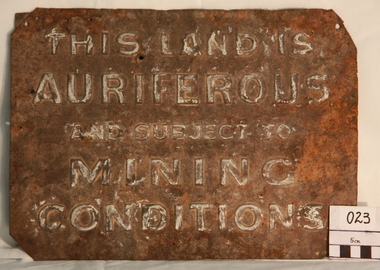
Gold Mining Sign
... of gold mining sites. Myrtleford district was known to have had... in the vicinity of gold mining sites. Myrtleford district was known ...This sign was required to be displayed in the vicinity of gold mining sites. Myrtleford district was known to have had 100 sites within a ten mile radius of the town; the sign was recovered by Charlie McFadyen, a local prospector and fossicker, of some 60 yearsThe sign relates to local gold mining activity, a key source of wealth and employment from 1854 to the late 19th century. Such signs continued to be in use during the period between World War 1 and 2,including the period of the Great Depression.Tin rectangular mining sign embossed with a warningInscription: "THIS LAND IS AURIFEROUS AND SUBJECT TO MINING CONDITIONS"auriferous mining -
 Bendigo Historical Society Inc.
Document - MCCOLL, RANKIN AND STANISTREET COLLECTION: NEW MOON EXTENSION, 1933
... Barker for lease of 5 acres mining site.... Bassett and John Severn Barker for lease of 5 acres mining site ...Document: Loose documents - draft and three carbon copies of a three page document. New Moon Extension - Garden Gully Line of Reef 9 miles north of Eaglehawk by H. E. Jones, 12/7/1933, report on the possibilities of the Garden Gully Line of Reef at Sebastian, by Robert Bentley, agreement Bassett and John Severn Barker for lease of 5 acres mining site.MCCOLL RANKIN & STANISTREETorganization, business, gold mining - legal, mccoll rankin & stanistreet -
 Bendigo Historical Society Inc.
Newspaper - VICTORIA HILL - VICTORIA HILL WORKING BEE
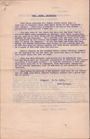
... and are placing signs which explain the various mining sites on the hill... the various mining sites on the hill. The photo shows a bulldozer ...Newspaper cutting with a photo of a working bee at the Victoria Hill site dated Tuesday, April 6, 1971. Members of Rotary, assisted by other service clubs, have cleaned up the whole area and are placing signs which explain the various mining sites on the hill. The photo shows a bulldozer pushing dirt, a group of men and the children holding signs. Article also gives a very brief history of the Hill.newspaper, bendigo advertiser, victoria hill, victoria hill, victoria hill working bee, south bendigo rotary club, victoria quartz mine, theodore ballerstedt -
 Bendigo Historical Society Inc.
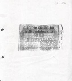
Newspaper - Kangaroo Flat Gold Mine Collection: Article, Facelift for Derelict Mining Sites, 6th November 1985
... mining sites?' Article describes how the Bendigo Council were..., headed '£100,000 facelift for derelict mining sites?' Article ...Newspaper article, (photocopied onto A4 paper) Bendigo Advertiser November 6th, 1985, headed '£100,000 facelift for derelict mining sites?' Article describes how the Bendigo Council were seeking a loan from the Goldfields Revolving Fund for the restoration of the Victoria Hill area and for the restoration of the relics and poppet legs of the Central Nell Gwynne, the Nell Gwynne Reef Mine, the North Deborah and the Big Deborah Mine sites.Written in black pen on right hand side: B'go Adv. Nov. 6th. '85gold mining, nell gwynne mine, north deborah mine, big deborah mine, poppet legs, bendigo, restoration -
 Bendigo Historical Society Inc.
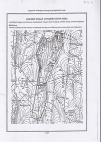
Document - DIAMOND HILL, GOLDEN GULLY COSERVATION AREA
... early reef mining sites' On top of page 'Eaglehawk & Bendigo... as well as several early reef mining sites' On top of page ...Map of Golden Gully conservation area comprising Glasgow and Golconda Consolidated, Glasgow Reef Company (Golden Gully) and New Napoleon. The area is significant because it contains the 'best evidence for hydraulic sluicing on the field as well as several early reef mining sites' On top of page 'Eaglehawk & Bendigo Heritage Study, Significant areas' Mines marked on page: Goldfields Extended shaft South Concord shaft Concord shaft Morning Light shaft Hansel and Mundy shaftbendigo, mining, golden gully -
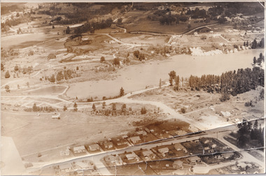
 The Beechworth Burke Museum
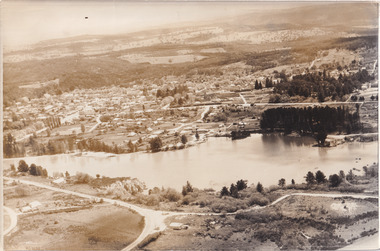
Photograph, Unknown
... as a mining site until the early 1900s, which brought Europeans... as a mining site until the early 1900s, which brought Europeans ...Aerial view of Lake Sambell, Beechworth with town views. Lake Sambell is a beautiful Victorian recreation lake and urban park with a unique history. It was created in the mid-1800s by the Rocky Mountain Mining company during the gold rush era and used as a mining site until the early 1900s, which brought Europeans into the area. It was turned into a reserve for residents in 1920 and is considered an icon of Beechworth as it represents the development of the community, human endeavour, and the spirit of the landscape.This photograph represents Lake Sambell with town views.Black and white reproduced rectangular photograph print on paper.Reverse: Stampbeechworth lake, lake sambell, aerial photo, construction, australian landscape, #beechworth, victoria -
 The Beechworth Burke Museum
Photograph, 1960
... rush era and used as a mining site until the early 1900s, which... rush era and used as a mining site until the early 1900s, which ...Taken in 1960, depicted is an aerial view of Lake Sambell and the surrounding township. Lake Sambell is a beautiful Victorian recreation lake and urban park with a unique history. It was created in the mid-1800s by the Rocky Mountain Mining company during the gold rush era and used as a mining site until the early 1900s, which brought Europeans into the area. It was turned into a reserve for residents in 1920 and is considered an icon of Beechworth as it represents the development of the community, human endeavour, and the spirit of the landscape.This photograph represents what Lake Sambell looked like in 1960.Black and white reproduced rectangular photograph print on paper.lake sambell, #beechworth, beechworth 1960s, lake, victoria, australian landscape, mining, rocky mountain mining company -
 The Beechworth Burke Museum
Photograph, 1960
... during the gold rush era and used as a mining site until... Mining company during the gold rush era and used as a mining site ...Taken in 1960, depicted is the construction of Lake Sambell, looking west across the lake. Lake Sambell is a beautiful Victorian recreation lake and urban park with a unique history. It was created in the mid-1800s by the Rocky Mountain Mining company during the gold rush era and used as a mining site until the early 1900s, which brought Europeans into the area. It was turned into a reserve for residents in 1920 and is considered an icon of Beechworth as it represents the development of the community, human endeavour, and the spirit of the landscape.This photograph represents additional construction to Lake Sambell as a recreational reserve.Black and white reproduced rectangular photograph print on paper.beechworth lake, lake, lake sambell, construction, #beechworth, australian landscape, beechworth 1960s, victoria -
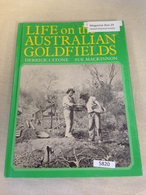 Stawell Historical Society Inc
Book, Derrick I. Stone & Sue Mackinnon, Life on the Australian Goldfields, 1976
... Early Photographs of mining towns and Sites as well...Early Photographs of mining towns and Sites as well ...Early Photographs of mining towns and Sites as well as people, throughout Australia.Hard Green cover with b/w photo of two miners with pans and hats. Life on the Australian Goldfields. Derrick I. Stone Sue Mackinnonstawell gold mining -
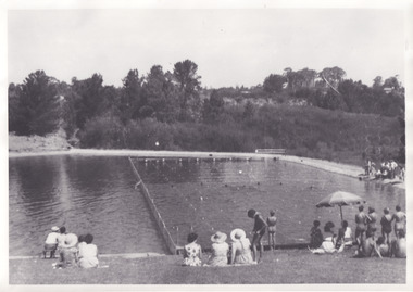 The Beechworth Burke Museum
Photograph, 1960s
... Mining company during the gold rush era and used as a mining site... Mining company during the gold rush era and used as a mining site ...Taken in the 1960s, depicted are approximately twenty-nine male and female spectators at a school swimming carnival on Lake Sambell near the caravan park. Lake Sambell is a beautiful Victorian recreation lake and urban park with a unique history. It was created in the mid-1800s by the Rocky Mountain Mining company during the gold rush era and used as a mining site until the early 1900s, which brought Europeans into the area. It was turned into a reserve for residents in 1920 and is considered an icon of Beechworth as it represents the development of the community, human endeavour, and the spirit of the landscape. This photograph represents the post-gold rush era use of Lake Sambell as a recreational reserve. Swimming carnivals were held at the lake and considered a social event for the Beechworth community.Black and white reproduced rectangular photograph print on paper.Reverse: Community/ Swimming pool 1960s/ near the caravan park/ Lakes?lake swimming pool, lake swimming, beechworth carnival processions, carnival, #beechworth, beechworth 1960s, victoria -
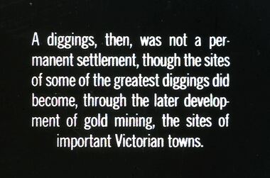 Bendigo Historical Society Inc.
Slide - DIGGERS & MINING. DIGGERS AND MINERS, c1860
... Diggers & Mining. Diggers and miners. A diggings... the later development of gold mining, the sites of important ...Diggers & Mining. Diggers and miners. A diggings, then, was not a permanent settlement, though the sites of some of the greatest diggings did become, through the later development of gold mining, the sites of important Victorian towns. Markings: 33 994:LIF I. Used as a teaching aid.hanimounteducation, tertiary, goldfields -
Bendigo Historical Society Inc.
Document - DIAMOND HILL HISTORIC AREA PARKS VICTORIA
... Surface gold mining site Hansel Mundy gold workings Bendigo... and tramway Surface gold mining site Hansel Mundy gold workings ...Document, two pages, prepared by Parks Victoria in relation to the Diamond Hill Historic Area. Contains information regarding the history of the area; German Miners; Plants and animals. On second page is a map of the area showing historic features: Deborah Consolidated Gold workings Red, White and Blue Extended gold workings Goldfields Extended gold workings Dead Dog Gully, alluvial gold workings Glasgow & Golconda Gold workings and tramway Surface gold mining site Hansel Mundy gold workings Bendigo Goldfields Pty gold workings Stafford gold workings Langdon gold workings Great Opossum Gully alluvial gold workingsbendigo, mining, diamond hill -
 Bendigo Historical Society Inc.
Document - RALH BIRRELL COLLECTION: OLD MINING SITES WHITE HILLS, Dr. Ralph Birrell (now deceased)
... , on the significance of the former mining sites on the White Hills. Document..., on the significance of the former mining sites on the White Hills. Document ...4-page typed document, prepared by Dr. Ralph Birrell, on the significance of the former mining sites on the White Hills. Document describes the 'area adjacent to the old Railway Workshops as shown on attached map'. A further addition (slip of paper, typed) to the paper describes the location of the Whiter Hills of White Hills: 1st White Hill is east of Lake Weeroona The 2nd and 3rd White Hills are around Strickland Road, former East Bendigo Primary School, Baden/Powell Streets The 4th and 5th White Hills are east of Napier and Grace Street The 6th White Hill is east of Plumridge Street The 7th White Hill is east of Bosquet Street. -
 The Beechworth Burke Museum
Photograph, 1920
... Mining company during the gold rush era and used as a mining site... Mining company during the gold rush era and used as a mining site ...Taken in 1920, depicted are four people in a rowing boat on Lake Sambell, Beechworth. From left to right, it is believed that the names of the people are Eric Beard, Mrs Doris Beard, and S/L to Bert Beard. The last two figures are unknown. Lake Sambell is a beautiful Victorian recreation lake and urban park with a unique history. It was created in the mid-1800s by the Rocky Mountain Mining company during the gold rush era and used as a mining site until the early 1900s, which brought Europeans into the area. It was turned into a reserve for residents in 1920 and is considered an icon of Beechworth as it represents the development of the community, human endeavour, and the spirit of the landscape.This photograph represents the community's social use of the lake in 1920.Black and white rectangular photograph print on paper.Reverse: LAKE SAMBELL/ c 1920/ from LTOR/ 1 ERIC? - BERT'S SON/ 2 MRS DORIS BEARD/ 3 S/L TO BERT BEARD/ 4 #beechworth, lake sambell, lake sambell boating, beechworth lake, social, 1920, victoria -
 The Beechworth Burke Museum
Photograph
... of Beechworth that was possibly used as a sluicing mining site for gold... of Beechworth that was possibly used as a sluicing mining site for gold ...This image shows an unknown location in the area of Beechworth that was possibly used as a sluicing mining site for gold during the Victorian Gold Rush. This era saw an influx of Chinese immigrants and Australian prospectors hoping to strike it rich on the fields. Many companies such as the Rocky Mountain Extended Gold Sluicing Company Ltd and the Cocks Pioneer Gold &Tin Sluicing Company also set up mines in the area. This site may be the location of one of these company's mines. The wooden logs are reminiscent of known sluicing operations in the era from that time. Sluicing involved the use of high-pressured hoses to clear away soil from earth that had been dug up by miners and was a popular method of excavation in the area, although it had severe impacts on the environment.The search for gold is ingrained into the history of Victoria and therefore, images like this one which portray an open cut sluicing site can reveal important information for society and technology for the date when the photograph was taken. This image is of important historical significance for its ability to convey information about sluicing and the methods used to find gold. It also shows a location where sluicing was undertook which provides insight into the impact of sluicing on the environment at a time when it was done.A colour rectangular photograph printed on glossy photographic paperReverse: 6855 /beechworth, gold rush, sluicing, mining -
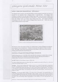 Bendigo Historical Society Inc.
Document - GLASGOW GONCONDA MINE SITE DIAMOND HILL
... and the Glasgow Reef mining history. The site is Glasgow Golconda mine... Golconda mine site and the Glasgow Reef mining history. The site ...Brief description of the Glasgow Golconda mine site and the Glasgow Reef mining history. The site is Glasgow Golconda mine is situated midway up Golden Gully is bounded on the north by Hill & Co's and on the south by the Golconda Company's ground.bendigo, mining, glasgow golconda -
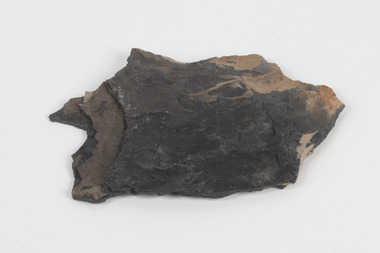 The Beechworth Burke Museum
Geological specimen - Oil shale
... mining sites in Wolgan Valley such as Newnes. Newnes... mining sites in Wolgan Valley such as Newnes. Newnes ...This particular specimen is found in Wolgan Valley, New South Wales. It could be linked to the abandoned oil shale mining sites in Wolgan Valley such as Newnes. Newnes was an industrial complex operational in the early 20th century is now partly surrounded by Wollemi National Park. It produced motor spirit, kerosene, and gas oil. Newnes's Torbanite oil shale rock contained around 350 litres of oil shale per tonne. The Torbanite was mined by the Commonwealth Oil Corporation Ltd. Oil shale is a sedimentary rock and also a form of fossil fuel. It is often formed millions of years ago and usually contain fossilised remains of plants and/or animals. Oil shale is rich in kerogen that releases hydrocarbon when heated. These hydrocarbon can be used as an alternative petroleum or natural gas. The oil-shale rock was converted into oil by "destructive distillation"; the rock being heated until it broke down to form an oily vapour and an ash residue. Oil bearing shale is one of Australia's national assets. There are many oil companies established in Australia. It reflects Australia's rich natural resources as well as connection to the Australia's engineering and oil industry. The booming oil shale extraction businesses can be traced as far back as 1920s. This specimen is part of a larger collection of geological and mineral specimens collected from around Australia (and some parts of the world) and donated to the Burke Museum between 1868-1880. A large percentage of these specimens were collected in Victoria as part of the Geological Survey of Victoria that begun in 1852 (in response to the Gold Rush) to study and map the geology of Victoria. Collecting geological specimens was an important part of mapping and understanding the scientific makeup of the earth. Many of these specimens were sent to research and collecting organisations across Australia, including the Burke Museum, to educate and encourage further study.Piece of dark gray oil bearing shale with shades of light brown and fossilised leavesExisting label: OIL BEARING SHALE with / FOSSILISED LEAVES / Locality: Wongan Valley, NSW / Donor: Miss M. Cambell geological specimen, geology, geology collection, burke museum, beechworth, oil shale, shale, fossil fuels, alfred selwyn, wolgen valley, 1868 geological survey of victoria, rocks, sedimentary rocks, newnes, torbanite, commonwealth oil corporation ltd -
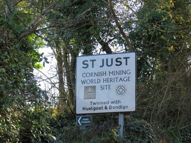 Ballarat Heritage Services
Photograph - Colour, Sign, St Just, Cornwall
... that St Just, Cornwall is a Cornish Mining World Heritage Site.... This sign reads that St Just, Cornwall is a Cornish Mining World ...Many miners came from the St Just are in Cornwall to Ballarat, Victoria, Australia for the gold rushes. This sign reads that St Just, Cornwall is a Cornish Mining World Heritage Site twinned with Huelgoat and Bendigo.ellis, st just, bendigo, miners -
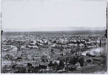 Stawell Historical Society Inc
Photograph, View of Stawell from Big Hill April 1874 showing mines centered on north end of Main Street -- 2 Photos
... Hill with mining in foreground. 1874 Site of fire in Main..., Matherson Cross Reef Hotel. mining panorama Streetscape Black ...From left Shire Hall Pleasant Creek in distance, Mathers & Franklin, Stawell Coach Factory, Coffee Palace, Christ Church of England Church Hill, Mechanics Institute, Temperance Hotel, Matherson Cross Reef Hotel.Black and White Holtermann photograph of Stawell from Big Hill with mining in foreground. 1874 Site of fire in Main and Street Patrick Street 22 April 1874 visible in centre of photograph.mining, panorama, streetscape -
 Bendigo Historical Society Inc.
Document - CENTRAL DEBORAH GOLD MINE - HISTORY OF CENTRAL DEBORAH GOLD MINE 1939 - 1954
... Mine from 1939 to 1954. Mentions the start of mining... of mining at this site and Victor Pabst, who in 1917 recommended ...4 typed pages of the history of the Central Deborah Gold Mine from 1939 to 1954. Mentions the start of mining at this site and Victor Pabst, who in 1917 recommended that the shaft be deepened. His advice was not acted on for another twenty-two years. Also mentioned is the geology and Method of Mining.mine, gold, central deborah gold mine, central deborah gold mine, history of central deborah gold mine, geology of the central deborah gold mine, method of mining -
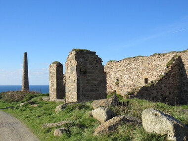
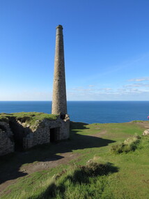
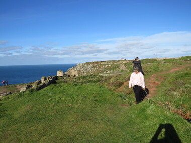
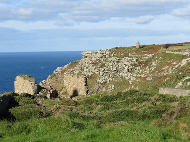
 Ballarat Heritage Services
Photograph - Colour, Dorothy Wickham, St Just, Cronwall, World Heritage Site
... and photographers. World-famous for their mineralogy, the mining sites here..., the mining sites here are extremely well preserved – as is the sense ...A stone’s throw from Land’s End, this is the most westerly Area of the Site. St Just is characterised by big skies, jagged rocks, stark moorland, and iconic clifftop engine houses perched above the Atlantic in some incredible locations. No wonder this dramatic setting has inspired generations of artists, writers and photographers. World-famous for their mineralogy, the mining sites here are extremely well preserved – as is the sense of community amongst the people whose lives they once dominated. This Area’s unique geography and mineralogy meant that undersea mining was more concentrated here than anywhere else in the world in the 18th and 19th centuries. The oldest surviving Cornish beam engine (constructed in 1840) remains in its original engine house at Levant, restored and still working under steam. Geevor, one of the last mines to close in Cornwall (1990), was saved from demolition and is now the largest metalliferous mine site open to the public in the UK. The historic mining town of St Just is home to characteristic rows of granite mine workers’ cottages, public squares, shops, cafés, art galleries and, just off Bank Square, a medieval grassed amphitheatre – the Plen an Gwary or ‘playing place’.st just, world heritage, ellis, penrose, cornwall, mining, mines -
 Ballarat Heritage Services
Photograph - Colour, Dorothy Wickham, St Just, Cornwall, World Heritage Site
... and photographers. World-famous for their mineralogy, the mining sites here..., the mining sites here are extremely well preserved – as is the sense ...A stone’s throw from Land’s End, this is the most westerly Area of the Site. St Just is characterised by big skies, jagged rocks, stark moorland, and iconic clifftop engine houses perched above the Atlantic in some incredible locations. No wonder this dramatic setting has inspired generations of artists, writers and photographers. World-famous for their mineralogy, the mining sites here are extremely well preserved – as is the sense of community amongst the people whose lives they once dominated. This Area’s unique geography and mineralogy meant that undersea mining was more concentrated here than anywhere else in the world in the 18th and 19th centuries. The oldest surviving Cornish beam engine (constructed in 1840) remains in its original engine house at Levant, restored and still working under steam. Geevor, one of the last mines to close in Cornwall (1990), was saved from demolition and is now the largest metalliferous mine site open to the public in the UK. The historic mining town of St Just is home to characteristic rows of granite mine workers’ cottages, public squares, shops, cafés, art galleries and, just off Bank Square, a medieval grassed amphitheatre – the Plen an Gwary or ‘playing place’.st just, world heritage,, ellis,, penrose, cornwall, mining, mines -
 Ballarat Heritage Services
Photograph - Colour, Dorothy Wickham, St Just, Cornwall, World Heritage Site
... and photographers. World-famous for their mineralogy, the mining sites here..., the mining sites here are extremely well preserved – as is the sense ...A stone’s throw from Land’s End, this is the most westerly Area of the Site. St Just is characterised by big skies, jagged rocks, stark moorland, and iconic clifftop engine houses perched above the Atlantic in some incredible locations. No wonder this dramatic setting has inspired generations of artists, writers and photographers. World-famous for their mineralogy, the mining sites here are extremely well preserved – as is the sense of community amongst the people whose lives they once dominated. This Area’s unique geography and mineralogy meant that undersea mining was more concentrated here than anywhere else in the world in the 18th and 19th centuries. The oldest surviving Cornish beam engine (constructed in 1840) remains in its original engine house at Levant, restored and still working under steam. Geevor, one of the last mines to close in Cornwall (1990), was saved from demolition and is now the largest metalliferous mine site open to the public in the UK. The historic mining town of St Just is home to characteristic rows of granite mine workers’ cottages, public squares, shops, cafés, art galleries and, just off Bank Square, a medieval grassed amphitheatre – the Plen an Gwary or ‘playing place’.st just, world heritage, ellis, penrose, cornwall, mining, mines -
 Ballarat Heritage Services
Photograph - Colour, Dorothy Wickham, St Just, Cronwall, World Heritage Site
... and photographers. World-famous for their mineralogy, the mining sites here..., the mining sites here are extremely well preserved – as is the sense ...A stone’s throw from Land’s End, this is the most westerly Area of the Site. St Just is characterised by big skies, jagged rocks, stark moorland, and iconic clifftop engine houses perched above the Atlantic in some incredible locations. No wonder this dramatic setting has inspired generations of artists, writers and photographers. World-famous for their mineralogy, the mining sites here are extremely well preserved – as is the sense of community amongst the people whose lives they once dominated. This Area’s unique geography and mineralogy meant that undersea mining was more concentrated here than anywhere else in the world in the 18th and 19th centuries. The oldest surviving Cornish beam engine (constructed in 1840) remains in its original engine house at Levant, restored and still working under steam. Geevor, one of the last mines to close in Cornwall (1990), was saved from demolition and is now the largest metalliferous mine site open to the public in the UK. The historic mining town of St Just is home to characteristic rows of granite mine workers’ cottages, public squares, shops, cafés, art galleries and, just off Bank Square, a medieval grassed amphitheatre – the Plen an Gwary or ‘playing place’.st just, world heritage, ellis, penrose, cornwall, mining, mines -
 Ballarat Heritage Services
Photograph - Colour, Dorothy Wickham, St Just, Cornwall, World Heritage Site
... and photographers. World-famous for their mineralogy, the mining sites here..., the mining sites here are extremely well preserved – as is the sense ...A stone’s throw from Land’s End, this is the most westerly Area of the Site. St Just is characterised by big skies, jagged rocks, stark moorland, and iconic clifftop engine houses perched above the Atlantic in some incredible locations. No wonder this dramatic setting has inspired generations of artists, writers and photographers. World-famous for their mineralogy, the mining sites here are extremely well preserved – as is the sense of community amongst the people whose lives they once dominated. This Area’s unique geography and mineralogy meant that undersea mining was more concentrated here than anywhere else in the world in the 18th and 19th centuries. The oldest surviving Cornish beam engine (constructed in 1840) remains in its original engine house at Levant, restored and still working under steam. Geevor, one of the last mines to close in Cornwall (1990), was saved from demolition and is now the largest metalliferous mine site open to the public in the UK. The historic mining town of St Just is home to characteristic rows of granite mine workers’ cottages, public squares, shops, cafés, art galleries and, just off Bank Square, a medieval grassed amphitheatre – the Plen an Gwary or ‘playing place’.st just, world heritage, ellis, penrose, cornwall, mining, mines -
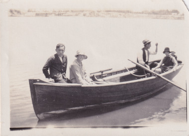
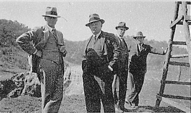 El Dorado Museum Association Inc.
Photograph - Digital Image
... Mining Dredge building site. Cropped image from scanned sheet... and Tin Mining Dredge building site. Cropped image from scanned ...Four men touring near the Cock’s Eldorado Gold and Tin Mining Dredge building site. Cropped image from scanned sheet of negative proofs. Cock's El Dorado Gold & Tin Mining Dredge operated between 1936 and 1954. At the time of its construction, the dredge was the largest in the Commonwealth, producing 2,198 kg of gold.mines, mining, gold, gold mining, men, hats, cock's el dorado dredge, dredge, el dorado, eldorado