Showing 314 items
matching murray valley
-
 Marysville & District Historical Society
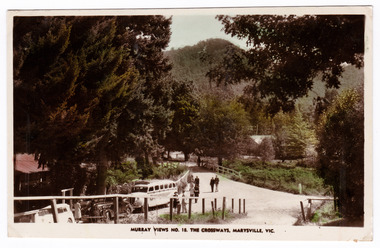
Postcard (Item) - Colour tinted postcard, Murray Views, MURRAY VIEWS NO. 18. THE CROSSWAYS, MARYSVILLE, VIC, Unknown
A black and white postcard of the Crossways in Marysville in Victoria published by Murray Views. The Crossways was built in the early 1920s and is the oldest building in Marysville. The Crossways historic inn survived the 2009 Black Saturday bushfires thanks to the efforts of its c-owner Greg Cherry and, in the days after the fires, provided a much-needed refuge to the Marysville community and firefighters. This postcard was produced by Murray Views in Gympie in Queensland as a souvenir of Marysville.A black and white postcard of the Crossways in Marysville in Victoria published by Murray Views.POST CARD STAMP REAL PHOTOGRAPH PRODUCED IN/ AUSTRALIA BY MURRAY VIEWS, GYMPIE, Q.marysville, victoria, australia, postcard, souvenir, crossways cabaret, crossways historic inn, crossways country inn, murray views no. 18, accommodation, 2009 black saturday bushfires -
 Marysville & District Historical Society
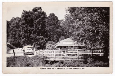
Postcard (Item) - Black and white postcard, Murray Views, MURRAY VIEWS NO. 27. CROSSWAYS CABARET, MARYSVILLE, VIC, Unknown
A black and white postcard of the Crossways Cabaret in Marysville in Victoria published by Murray Views. The Crossways was built in the early 1920s and is the oldest building in Marysville. The Crossways historic inn survived the 2009 Black Saturday bushfires thanks to the efforts of its c-owner Greg Cherry and, in the days after the fires, provided a much-needed refuge to the Marysville community and firefighters. This postcard was produced by Murray Views in Gympie in Queensland as a souvenir of Marysville.A black and white postcard of the Crossways Cabaret in Marysville in Victoria published by Murray Views.marysville, victoria, australia, postcard, souvenir, crossways cabaret, crossways historic inn, crossways country inn, murray views no. 27, accommodation, 2009 black saturday bushfires -
 Marysville & District Historical Society
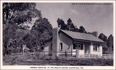
Postcard (Item) - Black and white postcard, Murray Views, Murray Views No. 49. The Health Centre, Marysville, Vic, Unknown
A digital copy of a black and white postcard of The Health Centre in Marysville in Victoria.A digital copy of a black and white postcard of The Health Centre in Marysville in Victoria. This postcard was produced by Murray Views in Gympie in Queensland as a souvenir of Marysville.marysville, victoria, murray views pty ltd, postcard, souvenir, the health centre, murray views no. 49 -
 Greensborough Historical Society
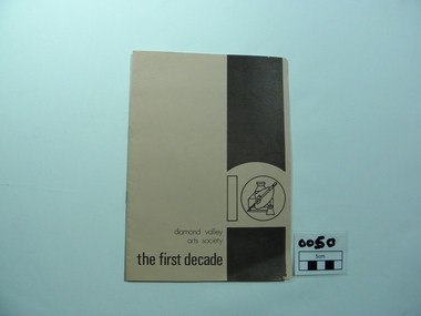
Booklet, The First Decade, 1981_
Early in the 1970s a number of people felt the need in the Greensborough community for an Arts Society, Prominent among them were were Ron Reynolds, Digby Watson, Murray Pulford, Roland and Maria Schultz. An article appeared in the Greenhills Community News seeking those interested in participating in such a society. A meeting was held in the home of Ron Reynolds on 15th July 1970 with approx. 20 people attending.Two tone light and dark brown cover with artists palette design on the front and sketch of Greensborough Primary School on rear coverOriginal owner written in pencil as June Hall arts society, ron reynolds, diamond valley art awards, digby watson, roland schultz, maria schultz, murray pulford, jan lowe, diamond valley arts society -
 Greensborough Historical Society
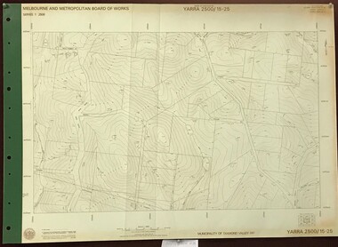
Map, Melbourne and Metropolitan Board of Works. Survey Division, MMBW, Yarra 2500 / 15.25. Yarrambat, Black Gully Road, 1978_07
Melbourne and Metropolitan Board of Works. Yarra 2500 [base map] 15.25. Yarrambat, Black Gully Road. Municipality of Diamond Valley 257. Prominent streets include: Black Gully Road, Ironbark Road and Murray Road. MMBW Map in 1:2500 [scale] series. Cream parchment with green tape reinforcing on edges and punched holes on left edge.mmbw, melbourne and metropolitan board of works, shire of diamond valley, yarrambat - maps -
 Greensborough Historical Society
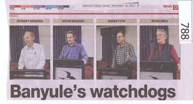
Newspaper clipping, Diamond Valley Leader, Banyule's watchdogs, 19/12/2012
The article is about a group of 4 people who regularly attend Banyule City Council meetings and ask questions of the Councillors. The four are Rosie Bray, Murray Newman, Roger Fyffe and Kevin Biaggini. All are residents of Banyule.A newspaper clipping featuring 5 coloured photographs. 2 copies.Nilrosie bray, murray newman, roger fyffe, kevin biaggini, banyule city council -
 Eltham District Historical Society Inc
Photograph, Edendale Farm, Eltham Heritage Tour, 24 May 1992, 24/05/1992
ELTHAM HERITAGE TOUR The Society excursion on 24th May 1992 was arranged by David Bick, leader of the team carrying out the Shire's heritage study. David selected a number of sites or buildings identified in the study, some of them lesser known components of the Shire's heritage. The tour commenced at the Eltham Shire Office at 10.00 am. Travel was by private car and mini-bus with stops at about twelve locations for commentary by David.It included a short walk in Hurstbridge and lunch at Kinglake. Highlights of the tour included: - 10 am Leave from Shire Offices - 3 Important Trees - A Physical Link to Eltham's First Settlers - Toorak Mansion Gates - A Surviving Farm House - An Intact Circa 1900 Main Street - First Settlers - Gold Miners, and Timber-getters - An Early Hotel - A Pioneering Homestead - Changing Eltham Shire - 20th Century - 4 pm Afternoon Tea and Finish Tour Extract from ELTHAM CULTURAL HERITAGE TOUR (Newsletter No. 85, July 1992, by Bettina Woodburn) "The land was unprofitable for intensive farming, but there was always water in the Diamond Creek. The railway, a technological advance, followed the valley, and was provided to transport produce. At North Eltham we were privileged to tour a surviving farmhouse of the 1860-70 era at the Shire’s Edendale Farm, with the as yet unfinished Sculpture for a front fence - bulbous tree-trunks decorated with salt pots, with cross members from the old trestle bridge. As was usual these six veranda posted houses faced South (or East, away from the sun!) with the scullery, kitchen and pantry "out the back". The veranda, which must have been very narrow, no longer exists. It probably wrapped around three sides. The drive took us past the Dutch Windmill, only twenty years old and in the Shire of Diamond Valley, then the Diamond Creek Cemetery with impressive gateway, to a detour to see another old farmhouse, isolated on a hill off Murray Road Wattle Glen. Here was a particularly thick patch of exotic planting of pines and cypresses. Subsistence farming no longer pays. Following the rail-line we noticed on the left near Silvan Road an Edwardian cottage and on the right near Yates Road the old school residence for this Upper Diamond Creek area."Record of the Society's history and activities and highlighting various aspects of the Heritage Study undertaken by David Bick used to create the future heritage overlay for the Shire of Eltham and later Nillumbik Shire.Roll of 35mm colour negative film, 4 stripsKodak Gold 100 5095eltham, shire of eltham historical society, activities, heritage tour -
 Eltham District Historical Society Inc
Photograph, Edendale Farm, Eltham Heritage Tour, 24 May 1992, 24/05/1992
ELTHAM HERITAGE TOUR The Society excursion on 24th May 1992 was arranged by David Bick, leader of the team carrying out the Shire's heritage study. David selected a number of sites or buildings identified in the study, some of them lesser known components of the Shire's heritage. The tour commenced at the Eltham Shire Office at 10.00 am. Travel was by private car and mini-bus with stops at about twelve locations for commentary by David. It included a short walk in Hurstbridge and lunch at Kinglake. Highlights of the tour included: - 10 am Leave from Shire Offices - 3 Important Trees - A Physical Link to Eltham's First Settlers - Toorak Mansion Gates - A Surviving Farm House - An Intact Circa 1900 Main Street - First Settlers - Gold Miners, and Timber-getters - An Early Hotel - A Pioneering Homestead - Changing Eltham Shire - 20th Century - 4 pm Afternoon Tea and Finish Tour. Extract from ELTHAM CULTURAL HERITAGE TOUR (Newsletter No. 85, July 1992, by Bettina Woodburn) "The land was unprofitable for intensive farming, but there was always water in the Diamond Creek. The railway, a technological advance, followed the valley, and was provided to transport produce. At North Eltham we were privileged to tour a surviving farmhouse of the 1860-70 era at the Shire’s Edendale Farm, with the as yet unfinished Sculpture for a front fence - bulbous tree-trunks decorated with salt pots, with cross members from the old trestle bridge. As was usual these six veranda posted houses faced South (or East, away from the sun!) with the scullery, kitchen and pantry "out the back". The veranda, which must have been very narrow, no longer exists. It probably wrapped around three sides. The drive took us past the Dutch Windmill, only twenty years old and in the Shire of Diamond Valley, then the Diamond Creek Cemetery with impressive gateway, to a detour to see another old farmhouse, isolated on a hill off Murray Road Wattle Glen. Here was a particularly thick patch of exotic planting of pines and cypresses. Subsistence farming no longer pays. Following the rail-line we noticed on the left near Silvan Road an Edwardian cottage and on the right near Yates Road the old school residence for this Upper Diamond Creek area."Colour photograph1992, culture, edendale, edendale community farm, events -
 Kiewa Valley Historical Society
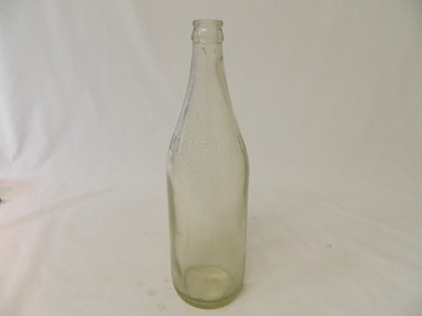
Bottle - Soft Drink, 1940s
Soft drink came in bottles bought at the local grocery store or at a large city store on a shopping expedition. the shape of the bottles changed as did the stopper used to seal it. Bottles were re cycled remaining the property of the manufacturer. History of Murray Brewery, BeechworthHistorical. Change of bottles - shape, glass, stopper, embossing, use. Aesthetic. Display showing the embossing & shape especially if in good condition.Clear glass bottle. Embossed print in capital letters, around half of the circumference, one third of the way down from the top between the 2 longitudinal joins. The bottom half has straight sides and the top half tapers to the top where a metal crimp fits over the lip. Around the circumference is embossed print in capital letters. The base also has embossing. Crown Seal.Around circumference one third from top: 'Murray B.' Around circumference at base: ' Propetery of Murray Breweries pty Ltd. Beechworth.' Base: F1767 Symbol: 'AGM' and '445' 'M O'beer, drinks, lemonade, beechworth brewery, murray breweries, bottles -
 Kiewa Valley Historical Society
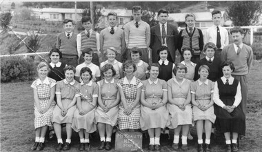
Photo: Students of Mt Beauty Higher Elementary School Form III, 1955
Mt Beauty Schooling -Black and white photo of students of the Mt Beauty High Elementary School 1955On the Back: George Murray / Photographer / 1A Belford Street / St Kilda Phone MU / Child Portraits A Specialitymt beauty school photo 1955 -
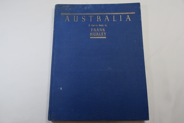 Kiewa Valley Historical Society
Book - Book- Photos, Australia - A Camera Study by / Frank / Hurley
Frank Hurley (1885-1962) was an Australian photographer and adventurer. He participated in trips to Antartica and was an official photographer with the Australian forces during both world wars. This book was first published in 1955.Photographs include the Hume Reservoir, Mt Buffalo and the Alpine High Country of Mt Kosciusko. (pages 140-144) All are associated with the type of country at each end of the Kiewa River. The Kiewa River flows into the Murray River just below the Hume Dam and Mt Buffalo and Mt Kosciusko are part of the Alpine High country near the Bogong High Plains. Clare Roper lived on a farm in the Kiewa Valley.Blue hard cover, bound book with the title in gold at the top. 208 pages. Mostly Black & white photos but some coloured.Inside back of first page - written 'Clare Roper'frank hurley photographer, australian photography, clare roper -
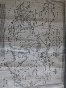 Kiewa Valley Historical Society
Map of the Ovens and Murray District of Victoria
The map features Beechworth and its history.This map features the north-east and in particular, Beechworth where residents of the Kiewa Valley may have shopped or visited for appointments.Black and white map with references to roads and gold. The centre of the map is Beechworth and in the bottom left side of the map is the heading Beechworth with 12 lines of print of information regarding Beechworth. The Kiewa Valley is not identified.beechworth -
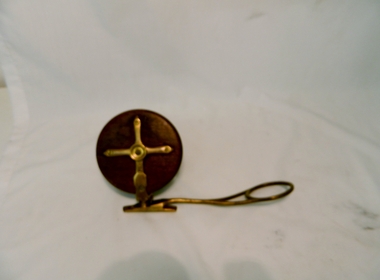 Kiewa Valley Historical Society
Reel Fishing, Circa 1920's to 1940's
These reels where used by a local family in catching Murray Cod and trout in the Kiewa Rivers and Murray River. This old Pilot side cast fishing reel was made in the late 20's & early 30's They were used in the mid 1950s. Although the original inhabitants (Aborigine tribe) would have used spears for fishing the use of reels and rods by non indigenous fisher persons are also very effective especially if raised in the valley.These items are significant because they demonstrate the harvesting of fish from valley rivers and streams is one of continuation from the first human habitation of this region. The ability to harvest the natural food source of the valley's rivers and streams has come from earlier survival requirement to one of recreational pleasure. Brass & Wooden Frame Side Casting Fishing Reel. This reel has 2 winding bakelite handles.Pilot, Tag states W. Davies Please return.recreation, river, kiewa, fishing, industry, reel, side, casting, davies -
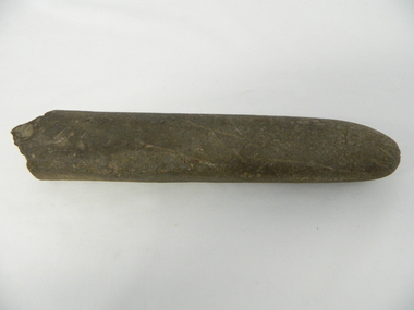 Kiewa Valley Historical Society
Grinder / Pounding Stone, Dhudhuroa language Aboriginal tribe, pre British/European colonisation
This stone Grinder or pounder was used as part of an indigenous grinding food preparation method, by the original inhabitants of the Kiewa Valley and its region. In conjunction with its grinding stone was used not only to grind seeds and but also to dig up eatable roots and leaves and served with the regions Bogong moth. This method of food preparation has survived in its basic form for centuries and is still used by master chiefs in modern eateries. This item has been registered with Aboriginal Affairs in Wangaratta, Victoria. Dhudhuroa elder Alan Murray has examined this tool, in Feb 2015, and said it was also used for sharpening axe heads as well as pounding food items. This item has a very significant historical and social aspect to it. Firstly it demonstrates the division of labour within a indigenous tribe. It was an era when the female had a definitive role within the family and the broader social indigenous tribal group of, gathering and preparing non animal(hunted) food. Hunted food was the domain of the initiated males of the tribe.Secondly it demonstrates the ability to fashion implements from raw materials(rock) into effective tools for the purpose of preparing a meal for human consumption. This was in an era where inter family and intra family participation in an indigenous tribal social protective environment was at a very high level. The Kiewa Valley/Mount Bogong region was an area where annual "get together" indigenous tribes for feasting, bartering and settling of disputes highlighting the importance of a regional gathering. Grooved stone, carved to a cylindrical shape with a relative pointed end tip one side (grinding or pounding end) and a rough other end (holding end} Made from Rhyolite stoneThere is a worn grove in the top side due to this tool being used for axe sharpening. indigenous, aboriginal, stone grinding, meal preparation, natural environment, pounding stone -
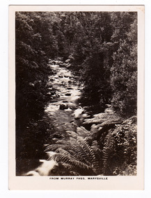 Marysville & District Historical Society
Photograph (item) - Black and white photograph, Rose Stereograph Company, From Murray Pass, Marysville, 1913-1967
An early black and white photograph of the Taggerty River from Murray Pass near Marysville, Victoria.An early black and white photograph of the Taggerty River from Murray Pass near Marysville, Victoria. Murray Pass is off the Lady Talbot Drive. Lady Talbot Drive a 24 kilometer scenic rainforest car journey which passes a number of walks and waterfalls in the Yarra Ranges National Park. Lady Talbot Drive is named after Lady Sarah Elizabeth, the wife of Sir Reginald Talbot, who was the Governor of Victoria from 25th April, 1904 to 6th July 1908.The photograph was also used to produce the Rose Series postcard P. 2309.marysville, victoria, photograph, taggerty river, murray pass, lady talbot forest drive, p. 2309, rose series postcard, souvenir, rose stereograph company, sir reginald talbot, lady sarah elizabeth talbot -
 Marysville & District Historical Society
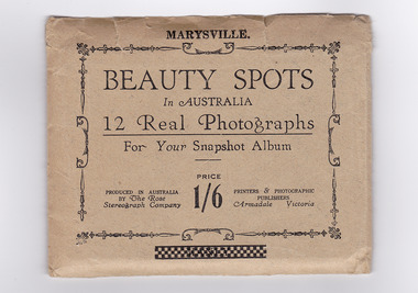
Photograph (item) - Black and white photographs, Rose Stereograph Company, Beauty Spots In Australia-Marysville, 1913-1967
An envelope with 12 black and white photographs of scenic attractions taken in and around Marysville in Victoria. The photographs were used for a series of photographs and postcards published by the Rose Stereograph Company in Armadale, Victoria.An envelope with photographs of scenic attractions taken in and around Marysville in Victoria.12 Real Photographs/ For Your Snapshot Album PRODUCED IN AUSTRALIA/ BY The Rose/ Stereograph Company PRINTERS & PHOTOGRAPHIC/ PUBLISHERS/ Armadale, Victoria PRICE/ 1/6keppel falls (image 1), cumberland falls (image 2), track to cora lynn falls (image 3), nichol's lookout (image 4), cameron cascades (image 5), stevenson falls (image 6), taggerty river (image 7), main street (image 8), glover walk (image 9), from murray pass (image 10), cora lynn falls (image 11), taggerty river (image 12), rose series postcard, rose stereograph company, souvenir -
 Marysville & District Historical Society
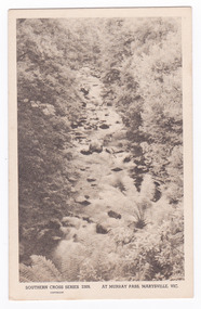
Postcard (item) - Black and white postcard, Rose Stereograph Company, At Murray Pass, Marysville, 1913-1967
A postcard in a series produced by the Rose Stereograph Company in Victoria, Australia as a souvenir of Marysville.An early black and white photograph of the Taggerty River from Murray Pass near Marysville, Victoria. Murray Pass is located on the Lady Talbot Drive. Lady Talbot Drive a 24 kilometer scenic rainforest car journey which passes a number of walks and waterfalls in the Yarra Ranges National Park. Lady Talbot Drive is named after Lady Sarah Elizabeth, the wife of Sir Reginald Talbot, who was the Governor of Victoria from 25th April, 1904 to 6th July 1908. This postcard was produced by the Rose Stereograph Company as a souvenir of Marysville.SOUTHERN CROSS SERIES 2309/ COPYRIGHT/ AT MURRAY PASS, MARYSVILLE, VIC. POST CARD. Correspondence Addressmarysville, victoria, photograph, taggerty river, murray pass, lady talbot forest drive, southern cross series, 2309, postcard, souvenir, lady talbot drive, sir reginald talbot, sarah elizabeth talbot -
 Marysville & District Historical Society
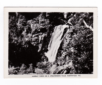
Photograph (item) - Black and white photograph, Murray Views, Murray Views No. 8. Steavensons Falls, Maryville, Vic, Post 1929
An early black and white photograph of Steavenson Falls, Marysville, Victoria.An early black and white photograph of Steavenson Falls, Marysville, Victoria. The Steavenson Falls is named after the Victorian Assistant Commissioner of Roads and Bridges, John Steavenson who arrived here in the early 1860s. This photograph was published by Murray Views in Gympie, Queensland, as a souvenir of Marysville.steavensons falls, steavenson falls, marysville, victoria, waterfall, murray views, photograph, souvenir, john steavenson -
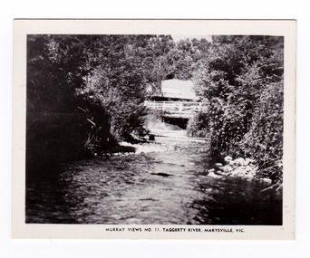 Marysville & District Historical Society
Photograph (item) - Black and white photograph, Murray Views, Murray Views No. 11. Taggerty River, Marysville, Vic, Post 1929
An early black and white photograph of the Steavenson River in Marysville, Victoria.An early black and white photograph of the Steavenson River in Marysville, Victoria. The Steavenson Falls is named after the Victorian Assistant Commissioner of Roads and Bridges, John Steavenson who arrived here in the early 1860s. This photograph was published by Murray Views in Gympie, Queensland, as a souvenir of Marysville.marysville, victoria, photograph, murray views, souvenir, steavenson river, john steavenson -
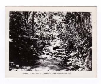 Marysville & District Historical Society
Photograph (item) - Black and white photograph, Murray Views, Murray Views No. 45. Taggerty River, Marysville, Vic, Post 1929
An early black and white photograph of the Taggerty River in Marysville, Victoria. An early black and white photograph of the Taggerty River in Marysville, Victoria. This photograph was produced by Murray Views in Gympie, Queensland as a souvenir of Marysville.taggerty river, marysville, victoria, murray views, photograph, souvenir -
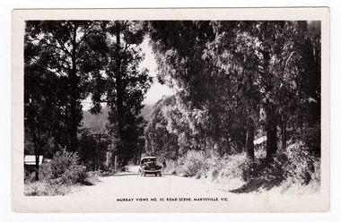 Marysville & District Historical Society
Postcard (item) - Black and white postcard, Murray Views, Murray Views No. 30. Road Scene, Marysville, Vic, Post 1929
An early black and white photograph of a road scene taken in Marysville, Victoria.An early black and white photograph of a road scene taken in Marysville, Victoria. This postcard was produced by Murray Views in Gympie, Queensland as a souvenir of Marysville."Kooringa"/ Monday Dear Mother/ Just a short note/ to say I am well & having a/ good holiday. Went on the/ Cumberland Valley trip last/ week - was very enjoyable./ To-day we are doing the Eildon/ Weir trip - all day. Have had/ fairly good weather - was able/ to go out every day. Will/ ring you later in the week/ about meeting me. If the/ strike is still on will probably/ get you to order a taxi for/ me. Lots of love/ Margaretmarysville, victoria, postcard, murray views, souvenir -
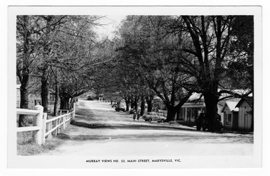 Marysville & District Historical Society
Postcard (item) - Black and white postcard, Murray Views, Murray Views No. 53. Main Street, Marysville, Vic, Post 1929
An early black and white photograph of the main street in Marysville in Victoria.An early black and white photograph of the main street in Marysville in Victoria. This street is now known as Murchison Street. This postcard was produced by Murray Views in Gympie, Queensland as a souvenir of Marysville.POST CARD STAMP REAL PHOTOGRAPH PRODUCED IN/ AUSTRALIA BY MURRAY VIEWS, GYMPIE, Q.murchison street, marysville, victoria, postcard, murray views, souvenir -
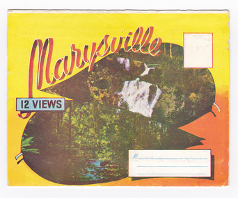 Marysville & District Historical Society
Postcard (item) - Colour photographs, Murray Views, Marysville 12 Views, 1950's
A fold out postcard of 12 colour photographs of scenes and landscapes in and around Marysville in Victoria.A fold out postcard 12 colour photographs of scenes and landscapes in and around Marysville in Victoria. These photographs were produced by Murray Views in Gympie, Queensland as a souvenir of Marysville.Marysville/ 12 VIEWS PRODUCED BY MURRAY VIEWS./ GYMPIE./ Q COPYRIGHT SAMUEL LEE & CO., PRINTERS. STEAVENSON'S FALLS, MARYSVILLE, VIC. TOURISTS AT MARYSVILLE, VIC. "FRUIT SALAD FARM", MARYSVILLE MAIN STREET, MARYSVILLE, VIC. ROAD SCENE, MARYSVILLE, VIC. THE CROSSWAYS, MARYSVILLE, VIC ROAD TO CUMBERLAND VALLEY, MARYSVILLE PANORAMA FROM BLACK SPUR, MARYSVILLE ROAD, MARYSVILLE, VIC. NICHOLL'S LOOKOUT, MARYSVILLE, VIC. TREE FERNS, MARYSVILLE, VIC. THE BRIDGE, MARYSVILLE, VIC.steavenson falls (image 1), tourists in marysville (image 2), taggerty river (image 3), fruit salad farm (image 4), main street marysville (image 5), road scene marysville (image 6), the crossways (image 7), cumberland valley (image 8), black spur (image 9), nicholl's lookout (image 10), tree ferns (image 11), bridge (image 12), marysville, victoria, postcard, souvenir, murray views -
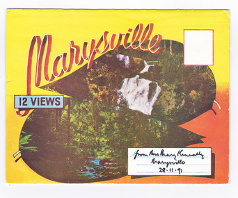 Marysville & District Historical Society
Postcard (item) - Colour photographs, Murray Views, Marysville 12 Views, 1950's
A fold out postcard of 12 colour photographs of scenes and landscapes in and around Marysville in Victoria.A fold out postcard 12 colour photographs of scenes and landscapes in and around Marysville in Victoria. These photographs were produced by Murray Views in Gympie, Queensland as a souvenir of Marysville.Marysville/ 12 VIEWS from Mrs Mary Keneally/ Marysville/ 28.11.91 PRODUCED BY MURRAY VIEWS./ GYMPIE./ Q COPYRIGHT SAMUEL LEE & CO., PRINTERS. STEAVENSON'S FALLS, MARYSVILLE, VIC. TOURISTS AT MARYSVILLE, VIC. "FRUIT SALAD FARM", MARYSVILLE MAIN STREET, MARYSVILLE, VIC. ROAD SCENE, MARYSVILLE, VIC. THE CROSSWAYS, MARYSVILLE, VIC ROAD TO CUMBERLAND VALLEY, MARYSVILLE PANORAMA FROM BLACK SPUR, MARYSVILLE ROAD, MARYSVILLE, VIC. NICHOLL'S LOOKOUT, MARYSVILLE, VIC. TREE FERNS, MARYSVILLE, VIC. THE BRIDGE, MARYSVILLE, VIC.steavenson falls (image 1), tourists in marysville (image 2), taggerty river (image 3), fruit salad farm (image 4), main street marysville (image 5), road scene marysville (image 6), the crossways (image 7), cumberland valley (image 8), black spur (image 9), nicholl's lookout (image 10), tree ferns (image 11), bridge (image 12), marysville, victoria, postcard, souvenir, murray views -
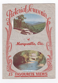 Marysville & District Historical Society
Postcard (item) - Colour and black and white photographs, Murray Views, Pictorial Souvenur of Marysville, Vic. 15 Favourite Views, 1950's
A fold out postcard of 15 colour and black and white photographs of scenes and landscapes in and around Marysville in Victoria.A fold out postcard of 15 colour and black and white photographs of scenes and landscapes in and around Marysville in Victoria. These photographs were produced by Murray Views in Gympie, Queensland as a souvenir of Marysville.Pictorial Souvenir/ of/ Marysville, Vic./ 15 Favourite Views PRODUCED BY MURRAY VIEWS. GYMPIE. Q. COPYRIGHT SAMUEL LEE & CO., PRINTERS Serial No. R 4152 NICHOLL'S LOOKOUT, MARYSVILLE, VIC. TAGGERTY RIVER, MARYSVILLE, VIC ROAD SCENE, MARYSVILLE, VIC. MAIN STREET, MARYSVILLE, VIC. THE CROSSWAYS, MARYSVILLE, VIC. FRUIT SALAD FARM, MARYSVILLE, VIC. ROAD TO CUMBERLAND VALLEY, MARYSVILLE, VIC. CROSSWAYS CABARET, MARYSVILLE, VIC. TREE FERNS, MARYSVILLE, VIC. STEVENSON'S FALLS, MARYSVILLE, VIC. Looking towards Marysville, Vic. Tourists at Marysville, Vic. Taggerty River, Marysville, Vic. On Buxton Road, Marysville, Vic. Panorama from Black Spur, Marysville Road, Marysville, Vic.marysville, victoria, souvenir, postcard, nicholl's lookout (image 1), taggerty river (image 2), road scene (image 3), main street marysville (image 4), crossways hotel (image 5), fruit salad farm (image 6), cumberland valley (image 7), crossways cabaret (image 8), tree ferns (image 9), steavenson falls (image 10), marysville view (image 11), tourists marysville (image 12), taggerty river (image 13), buxton road (image 14), black spur (image 15) -
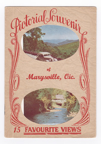 Marysville & District Historical Society
Postcard (item) - Colour and black and white photographs, Pictorial Souvenir of Marysville, Vic. 15 Favourite Views
A fold out postcard of 15 colour and black and white photographs of scenes and landscapes in and around Marysville in Victoria.A fold out postcard of 15 colour and black and white photographs of scenes and landscapes in and around Marysville in Victoria. These photographs were produced by Murray Views in Gympie, Queensland as a souvenir of Marysville.Pictorial Souvenir/ of/ Marysville, Vic./ 15 Favourite Views PRODUCED BY MURRAY VIEWS. GYMPIE. Q. COPYRIGHT SAMUEL LEE & CO., PRINTERS Serial No. R 4152 NICHOLL'S LOOKOUT, MARYSVILLE, VIC. TAGGERTY RIVER, MARYSVILLE, VIC ROAD SCENE, MARYSVILLE, VIC. MAIN STREET, MARYSVILLE, VIC. THE CROSSWAYS, MARYSVILLE, VIC. FRUIT SALAD FARM, MARYSVILLE, VIC. ROAD TO CUMBERLAND VALLEY, MARYSVILLE, VIC. CROSSWAYS CABARET, MARYSVILLE, VIC. TREE FERNS, MARYSVILLE, VIC. STEVENSON'S FALLS, MARYSVILLE, VIC. Looking towards Marysville, Vic. Tourists at Marysville, Vic. Taggerty River, Marysville, Vic. On Buxton Road, Marysville, Vic. Panorama from Black Spur, Marysville Road, Marysville, Vic.marysville, victoria, souvenir, postcard, nicholl's lookout (image 1), taggerty river (image 2), road scene (image 3), main street marysville (image 4), crossways hotel (image 5), fruit salad farm (image 6), cumberland valley (image 7), crossways cabaret (image 8), tree ferns (image 9), steavenson falls (image 10), marysville view (image 11), tourists marysville (image 12), taggerty river (image 13), buxton road (image 14), black spur (image 15)