Showing 434 items matching "nepean"
-
 City of Kingston
Photograph - Black and white, c. 1950
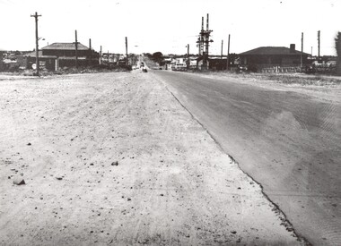
This image shows a sealed road running along South Road, although with a wide gravel shoulder. The railway crossing gates were hand operated. This image is one of many in the collections that focuses on the railway. The development of the railway was crucial to the ongoing development of the area. Community life often sprang up along and beside the railway.Black and white photograph of the railway crossing at South Road, Moorabbin, viewed from Nepean Highway. Handwritten in blue ink on reverse: 217 Handwritten in red ink on reverse: 80%moorabbin, railway, railway crossing -
 Bendigo Historical Society Inc.
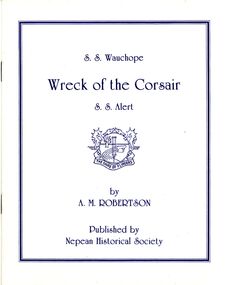
Book - STRAUCH COLLECTION - WRECK OF THE CORSAIR
Booklet titled Wreck of the Corsair, S.S.Wauchope, S.S.Alert, by A M Robertson published by Nepean Historical Society.A.M.Robertsonhistory, naval, shipwrecks, victoria-point nepean- shipwrecks-corsair-wauchope-alert -
 Federation University Historical Collection
Book, William J. Goudie, Steam Turbines, 1922, 1922
Green hard covered bookInside front cover "R.F. Symons Holmby Lodge Point Nepean Road Cheltenham"steam, r.f. symons -
 Glen Eira City Council History and Heritage Collection
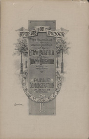
Booklet, "AVENUES OF HONOUR The Councils of the Municipalities of the CITY OF CAULFIELD TOWN OF BRIGHTON acting in conjunction PUBLIC DEMONSTRATION SAT 3rd AUG. 1918 AT 3oCLOCK"
Souvenir Programme from the Councils of the Municipalities of the City of Caulfield and the Town of Brighton for a Public Demonstration to be held on Sat 3rd August 1918 at 3 o'clock for the proposed Avenues of Honour to be planted in memory of fallen WWI soldiers. From Honour Roll Display 2019 interpretation panel - Brighton-Caulfield Avenue of Honour It is hard to imagine but a grand arboreal Avenue of Honour once lined parts of North Road, McMillan Street and Point Nepean Road (now Nepean Highway). The Avenue of Honour was a distinctly Australian phenomenon with hundreds being constructed throughout Australia during and following World War One, most of these in Victoria. Consisting of tree lined streets with each tree representing a solider, the Avenue of Honour signalled a more egalitarian approach to commemoration where rank was not a consideration. Arguably the most famous Avenue of Honour in Victoria still exists at Ballarat. Stretching for nearly 22 kilometres, the entrance to the Avenue is marked by the imposing Arch of Victory. Smaller in scale, the Brighton-Caulfield Avenue of Honour was dedicated to the ‘memory of (Brighton and Caulfield’s) kith and kin who came from (the) district and who died in the Great War’. A joint project between the neighbouring Councils, the idea was first reported in The Argus on 1 July 1918. Plans moved along quickly and on 3 August 1918 the Governor of Victoria Arthur Stanley planted the first Australian flowering gum. The next of kin were then invited to plant trees for lost sons, brothers, uncles, nephews and husbands. In all, over 400 trees were planted. Intensely personal, the Avenue also acted as a focus of grief and remembrance for the wider community. For many years, the annual civic Anzac Day service was held at the Avenue on Point Nepean Road, near Glen Huntly Road, Elsternwick. The service was moved to Caulfield Park upon the completion of the Cenotaph in 1930. Due to road widening and disease the last original tree was replaced in the 1980s, however a plaque in Caulfield Park records the Avenue’s plantation. Commemorative booklet, grey cover with text printed on the grey textured paper cover and an image of four trees and a wreath. Image of a kookaburra on the back. Inside, 28 numbered pages with b/w text and photographic images including a transparent paper representation of the proposed Avenues of Honour on Brighton Road and Point Nepean Road. Souvenir programme for a Public Demonstration for the Avenues of Honour as detailed on the front.city of caufield, world war one, first world war, anzac, remembrance, town of brighton, brighton, caulfield, avenue of honour -
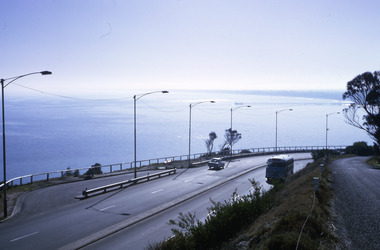 Robin Boyd Foundation
Slide, Robin Boyd, 1967
Colour slide in a mount. View of Port Phillip Bay, Nepean Highway, Olivers Hill, Frankston, VictoriaMade in Australia / 20 / JUN 67M1 / Encircled 44 (Handwritten)slide, robin boyd -
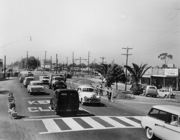 City of Kingston
Photograph - Black and white, c. 1957
Copy black and white photograph of railway level crossing on Nepean Highway Moorabbin before excavations for the below ground rail crossing. The level crossing gates are closed and five cars are waiting, while other cars can be seen coming in the opposite direction. A woman with a child in a pram is walking along the road, and a number of men, probably construction workers, are standing behind a barricade on the right hand side of the road. Gilbey's Gin distillery is visible in the background. TCopy black and white photograph of railway level crossing on Nepean Highway Moorabbin before excavations for the below ground rail crossing. The level crossing gates are closed and five cars are waiting, while other cars can be seen coming in the opposite direction. A woman with a child in a pram is walking along the road, and a number of men, probably construction workers, are standing behind a barricade on the right hand side of the road. Gilbey's Gin distillery is visible in the background. Handwritten in blue ink on reverse: 57-465C Handwritten in red ink on reverse: 71% A red circle has been drawn around all handwritten text.moorabbin, railway station, railway crossing, suburbs, cars, local production -
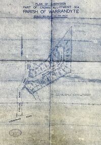 Ringwood and District Historical Society
Map - Plan of Subdivision, Part of Crown Allotment 31A, Parish of Warrandyte - (Undated)
Facsimile blueprint copy of 24 residential allotments with property dimensions in Bailey Crescent (later Gabriella Court) and McEwan Street (later Suzanne Court) off Park Road and Evelyn Road, Ringwood North. Attached photocopy of undated map of allotment on south-east corner of Evelyn and Park Roads.Rubber stamp impression - J. Horne, Licensed Surveyor, 458 Nepean Highway, Frankston 31736. -
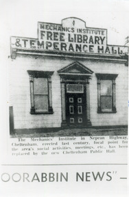 City of Moorabbin Historical Society (Operating the Box Cottage Museum)
Photograph, Black & White, Cheltenham Mechanics Institute,Library, Temperance hall, c1960
The Mechanics Institute, built c 1890, was the focal point for the Cheltenham area's social activities, public meetings, adult education, etc. until its demolition 1960 when a new Cheltenham Hall was erectedThe early settlers erected this Mechanics Institute prior to 1900 as a public meeting place, library, temperance hall and it was used for social eventsBlack & White photograph in the Moorabbin News c 1960 showing the Mechanics Institute, c1900 Nepean Highway Cheltenhamcheltenham mechanics institute, cheltenham temperance hall, cheltenham church of christ, keys robert, lepage everet, moorabin news, leader newspapers, horse drawn carts, toll gates brighton, motor cars 1900, steam engines, early settlers, bentleigh, mckinnon, parish of moorabbin, city of moorabbin, county of bourke, moorabbin roads board, shire of moorabbin, henry dendy's special survey 1841, were j.b.; bent thomas, o'shannassy john, king richard, charman stephen, highett william, ormond francis, maynard dennis, market gardeners, vineyards, orchards -
 Whitehorse Historical Society Inc.
Article, Honour for a peninsular defender, 2009
Ian Haskins, a Forest Hill environmentalist, received an Order of Australia for his work with the Point Nepean Reference Group.Ian Haskins, a Forest Hill environmentalist, received an Order of Australia for his work with the Point Nepean Reference Group.Ian Haskins, a Forest Hill environmentalist, received an Order of Australia for his work with the Point Nepean Reference Group.haskins, ian -
 Bayside Gallery - Bayside City Council Art & Heritage Collection
Photograph, Department of Crown Lands and Survey, Victoria, Brighton, Brighton East and Bentleigh, c. 1965-71
The Department of Crown Lands and Survey (1857-1983) was responsible for the administration of survey and mapping and the sale, occupation and management of crown land throughout its existence. This aerial photograph shows parts of Brighton, Brighton East and Bentleigh and was taken circa 1965-71.brighton, department of crown lands and survey, aerial photograph, bayside, port phillip bay, map, cartographic material, bentleigh, brighton east, dendy park, dendy street, centre road, nepean highway, south road, football -
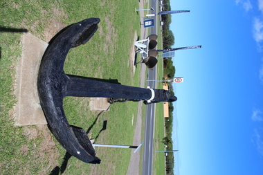 Queenscliffe Maritime Museum
Functional object - Anchor from Eliza Ramsden
The Eliza Ramsden, with its intact clipper bow, is one of Victoria's most aesthetically spectacular shipwreck sites, and thus has both recreational and educational significance. It is archaeologically significant as relics of cultural significance, including a small ship's bell, have been found on the site.Struck Corsair Rock and later sank in South Channel, Port Philip on 24 July 1875. Now a popular diving site. Large Anchor ex Eliza Rambden which was wrecked on Corsair Rock Point Nepean 24/071875 Made of Cast Ironeliza ramsden, shipwrecks, port phillip, anchors -
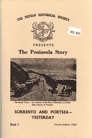 Bendigo Historical Society Inc.
Book - STRAUCH COLLECTION: THE PENINSULA STORY BOOK 1
BHS CollectionThe Peninsula Story Book 1 Sorrento and Portsea Yesterday presented by the Nepean Historical Society, 63 pages with black and white photographs & maps.victoria, history, nepean peninsula, victoria-history-nepean peninsula- sorrento - portsea -
 Robin Boyd Foundation
Slide, Robin Boyd
Colour slide in a mount. Watt House (c. 1949), 2901 Point Nepean Road, Blairgowrie, Victoria, Australia. (Architects: Mockridge Stahle & Mitchell)Made in Australia / Encircled 35 (Handwritten)slide, robin boyd -
Clunes Museum
Container - BOTTLE
BROWN SCREWTOP BOTTLE CONTAINING OIL OF CLOVES - ONE POUND SIZE, DISPENSED BY W.I. BUSH AND CO. 3 NEPEAN HIGHWAY, MENTONE, VIC.local history, medicine, dentistry, medical pharmacy -
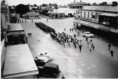 Old School House Museum
Photograph
Copy of an older photo, Corner of Bay St (Nepean Highway) and Playne St Frankston. Marching band followed by Possible service men or scouts -
Lakes Entrance Historical Society
Book, Loney Jack, Wrecks on the Gippsland Coast, 1968
Shipwrecks and incidents along the coast and in Bass Strait from Point Nepean to Cape Howe. Indexes of Ships and Localities included. Some ship illustrated.A J and H Murrell stamped on first pageshipwrecks, ships and shipping, lighthouses -
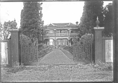 City of Moorabbin Historical Society (Operating the Box Cottage Museum)
Photograph - 3 black & white Photographs, 'The Grange' ( 'Baydon Hill' ) Moorabbin, c 1920
'The Grange ' was a 2 storey home built 1857 by Mr Charles Tuck, originally named 'Baydon Hill' , at 1011 Nepean Highway, Moorabbin ( South Brighton). Mr Charles Tuck was Veterinary Surgeon from Baydon Hill, Wiltshire, England, who migrated to Australia c1850. He married his cousin Miss Jan Chaudler in Melbourne in1853. He was at the Ballarat gold-fields at the time of the riots and then they settled in South Brighton ( later Moorabbin) and built a large Georgian Styled home called 'Baydon Hill'. The Tucks had a large family - 9 children. Charles enjoyed a prosperous Veterinary Practice as his advice was needed for stock purchases by the farmers / settlers. Charles died in 1893 and Jane left the property c 1903 and died at Blackburn in 1928. The House had 5 owners, the last being the Healey family c1920 and at some stage the name was changed to 'The Grange' and the gates shown were installed. The Healey Family were also prosperous in developing vegetables and flower seeds and seedlings. 'The Grange' was sold to Moorabbin City Council 1972 and then used by the City of Moorabbin Historical Society for meetings and storage of historical material. It was demolished amidst considerable controversy 1983 and the District Police Offices were built on the site. ( S.T.Mulvany, Grand-daughter of Charles Tuck 26/7/1974)The Grange was a significant property 1853 -1983 in Moorabbin. It was built by Mr Charles Tuck 1857and in1900 extended from Point Nepean Road to South Road - 10acres. Mr Harold James Healey purchased the property in c1920 and leased a portion to a Chinese market gardener. Later with his sons he established a profitable Plant Nursery that they managed for 42years.. Keith Healey, a son, remodelled the house extensively mid 20thC .The Moorabbin City Council purchased it in 1972 for $255,000 and it was demolished amid controversy 1983. The District Police Offices are now on the site.3x black and white photographs of the property at 1011 Nepean Highway Moorabbin built by Mr Charles Tuck c1853 known as 'The Grange'. Originally it was named 'Baydon Hill' because he migrated from Baydon Hill, Wiltshire, England c1850. These photographs are c 1880, 1920 and 1950 showing the original and later additions made to the property by some of the 5 owners.Written in pencil on back a) " This Photo donated by Mr Neil Follett - at the time it came into his possession he had a photography studio in Cheltenham. Photographer unknown"; Folio 6 b) The Grange c 1950 Folio 6/10 c) 'Baydon Hill' ( alias "The Grange" ) / Donated by Mrs Elsa Jones, daughter of Leslie Stephen Tuck, youngest son of Charles Tuck Folio 6 /18tuck charles, tuck jane, veterinary surgeons, livestock, market gardeners, early settlers, dendy's special survey, brighton, moorabbin, ballarat, gold diggings, horses, chickens, cattle, bullocks, flower shows, fruit garden, mulvaney s. t., healey haold james, healey keith, moorabbin city council, chinese market gardeners, plant nursery, tuck leslie stephen, jones elsa -
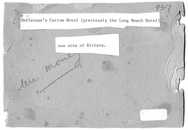 Chelsea & District Historical Society Inc
Photograph - Heffernan's Hotel, Carrum, c 1912
Thomas Heffernam (1860-1934) purchased the Carrum Hotel situated in Point Nepean Road (now Nepean Highway). The hotel was previously called Long Beach Hotel. The Riviera Hotel now occupies this site (2025).Black and white photo of a group of people standing in front of Carrum Hotel (Heffernan's), CarrumHeffernan's Carrum Hotel; Afternoon Teacarrum, seaford, carrum hotel, horse and cart, long beach hotel, riviera hotel, heffernan -
 Bendigo Military Museum
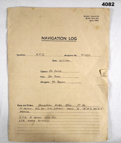
Document - NAVIGATION DOCUMENT, Navigation Log, 22.11.1942
Navigation Log for flight by A.T.S in Aeroplane W - 2275 operating under order No 18/40. Details filled in on form RAAF A.84. Form filled in by F/L Smith, Sgt Jones, P/O Jones. Part of the Frederick Gardner DFC RAAF No 410533 collection. Refer Cat No 3536P for his service details.Four page Proforma printed in black ink, handwritten details in pencil on pages 1,2,3.The hand written information pages 1,2,3, details a flight from Pt Nepean to Woodside, weather, wind speed and observation points noted.training flight, raaf, w - 2275 -
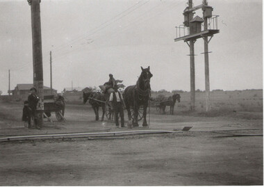 City of Moorabbin Historical Society (Operating the Box Cottage Museum)
Photograph - Plateway (Wheelway) Steel, circa 1885
By the later 1800s the dirt roads in the then out-lying areas of the City of Moorabbin became dangerous, and almost impassable due to huge potholes and muddy swampy areas. The heavily laden market gardener’s carts regularly broke axles and wheels, and horses foundered on their way to the Melbourne markets. Even worse, the heavier “iron maidens”, carrying their malodorous loads of sewage from Melbourne’s inner suburbs for dumping in the outlying areas of the City of Moorabbin, also got bogged in the mire. It was decided that a practical solution to this problem was to install a metal plateway on the side of the problematic roads. In about 1887 the Moorabbin Shire Centre Road, in the Brighton East area, two parallel metal rails were installed so that the wheels of carts could run along smoothly, the horse travelled in the filled, middle area between the rails. Point Nepean Road plateway was removed in 1930 and Centre Dandenong Road plateway was removed in 1934-35. The worn plateway along Centre Road, East Brighton (now known as Bentleigh), was gradually taken up in several pieces, commencing in the the1920s, when its condition deteriorated and it caused a hazard to bikes, pedestrians, motor-cycles and the few early cars. The early steel plateway, constructed by David Munro, and opened on 23rd March 1885 by Thomas Bent, was built along Nepean Highway, between Asling St. and Bay St. The Point Nepean Track was subsequently extended into Moorabbin with branches along Centre, Cumins, South, Wickham, and Keys Roads, the total length was 13 miles. In 1908-1909 plates were laid along Centre Dandenong Road to Ross Street Bentleigh This innovative solution proved successful and was used until gradually the main roads were upgraded, and motorised vehicles started to appear. Two parallel metal rails were installed in the right hand side of a few main roads in the Shire of Moorabbin so that the wheels of heavily-loaded market gardener's carts on their way to markets in Melbourne could run along smoothly. The horse pulling the carts travelled in the filled, middle area between the rails. The Steel Plateway was constructed by David Munro, and opened on 23rd March 1885 by Thomas Bent. The wheelway first only ran along Nepean Highway, but it soon extended from Centre Dandenong Road, along Nepean road to its junction with Chapel Street, St Kilda. Later branch lines were built along Centre Road, Bentleigh as far as Warrigal Road and, according to early photographs, along Wickham Road Moorabbin as well. This innovative solution proved successful and was used until gradually the main roads were upgraded, and motorised vehicles started to appear. There was a problem with the wheelway : there was only a single set of rails and this was established on the right-hand side of the Nepean Road, travelling towards the city. Traffic FROM the city travelled on the correct or left-hand side of the road. The exception to this rule was the malodorous iron-clads, heavily riveted iron carts, generally travelling in convoy, carrying several tons of human effluent out of Melbourne to be trenched-in in the sandy soil of the Moorabbin district. Moorabbin City Council donated and installed a small section of Plateway at Box Cottage Museum in 1984melbourne, brighton, moorabbin, roads, plateway, wheelway, transport, st kilda, bent thomas, munro david, market gardens, steelway, carts horse-drawn, iron maidens, point nepean track -
 City of Kingston
Pamphlet - Colour, Moorabbin News Print, Auction = Sale Heather Grove Estate, c. 1914
Sales plan for land in the suburb of Cheltenham, bounded by Tulip Grove and Heather Grove.The developing urban area of Highett within the City of Kingston. This land sale pamphlet illustrates the subdivision of land within the municipality and the changing demographic of the district as new houses are constructed close to infrastructure.Colour pamphlet advertising auction of Heather Grove Estate, Cheltenham. Incorporates a map of the estate bordered by Wickham Road, Railway Parade, Highett Road and Point Nepean Road.Handwritten in grey pencil on subdivision 1: Sold / 20/- Handwritten in grey pencil on subdivision 2: 25/- Handwritten in grey pencil on subdivision 3: 30/- Handwritten in grey pencil on subdivision 4: 110 / 30/- Handwritten in grey pencil on subdivisions 1, 11, 10, 9 and 8: Sold Handwritten in grey pencil beneath 'Heather Grove': 20/- 20/- 20/- 20/- Handwritten in black ink on subdivison 12 and 7: £85 Handwritten in back ink on subdivision 5: £60 Handwritten in back ink on subdivision 6: £65 Handwritten in grey pencil above subdivision map: 1-8-9-10-11 Handwritten in grey pencil above subdivision map: [enclosed in a circle] 12- / £75 Handwritten in grey pencil above subdivision map: [enclosed in a circle] 2 / £85 Handwritten in grey pencil above subdivision map: [enclosed in a circle] 3 / £100 Handwritten in grey pencil above subdivision map: [enclosed in a circle] 4 / £100 Handwritten in grey pencil above subdivision map: [enclosed in a circle] 5 / £60 Handwritten in grey pencil above subdivision map: [enclosed in a circle] 6 / £65 Handwritten in grey pencil above subdivision map: [enclosed in a circle] 7 / £25- Handwritten in grey pencil above subdivision map: [enclosed in a circle] £125 / [indecipherable] Handwritten in grey pencil above subdivision map: 37.00 / 18.10 / 56.80 / 3 / [horizontal line] / 59 8 Handwritten in grey pencil along railway line marking: 21/6 / 12/6 / 13/- / 19/-land sales, estate, cheltenham -
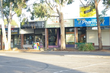
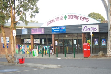 Greensborough Historical Society
Photograph - Digital image, Marilyn Smith, Diamond Village Shopping Centre, Watsonia, 2016, 22/05/2016
Diamond Village Shopping Centre, Nepean Street Watsonia.Digital copy of colour photograph.diamond village shopping centre, watsonia -
 Greensborough Historical Society
Photograph - Digital image, Marilyn Smith, Diamond Village Shopping Centre, Watsonia, 2016, 22/05/2016
Diamond Village Shopping Centre, Nepean Street Watsonia.Digital copy of colour photograph.diamond village shopping centre, watsonia -
 Greensborough Historical Society
Photograph - Digital image, Marilyn Smith, Diamond Village Shopping Centre, Watsonia, 2016, 22/05/2016
Diamond Village Shopping Centre, Nepean Street Watsonia.Digital copy of colour photograph.diamond village shopping centre, watsonia -
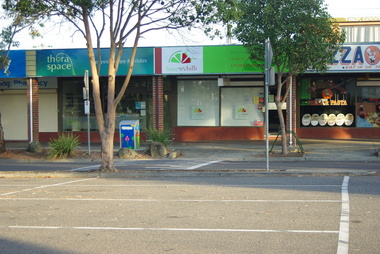
 Greensborough Historical Society
Photograph - Digital image, Marilyn Smith, Diamond Village Shopping Centre, Watsonia, 2016, 22/05/2016
Diamond Village Shopping Centre, Nepean Street Watsonia.Digital copy of colour photograph.diamond village shopping centre, watsonia -
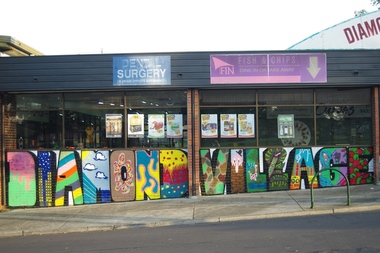
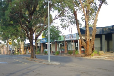
 Greensborough Historical Society
Photograph - Digital image, Marilyn Smith, Diamond Village Shopping Centre Trees, Watsonia, 2016, 22/05/2016
Diamond Village Shopping Centre, Nepean Street Watsonia.Digital copy of colour photograph.diamond village shopping centre, watsonia -
 Greensborough Historical Society
Photograph - Digital image, Marilyn Smith, Diamond Village Shopping Centre, Watsonia, 2016, 22/05/2016
Diamond Village Shopping Centre, Nepean Street Watsonia.Digital copy of colour photograph.diamond village shopping centre, watsonia -
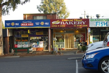
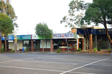
 Greensborough Historical Society
Photograph - Digital image, Marilyn Smith, Diamond Village Shopping Centre, Watsonia, 2016, 22/05/2016
Diamond Village Shopping Centre, Nepean Street Watsonia.Digital copy of colour photograph.diamond village shopping centre, watsonia -
 Greensborough Historical Society
Photograph - Digital image, Marilyn Smith, Diamond Village Shopping Centre, Watsonia, 2016, 22/05/2016
Diamond Village Shopping Centre, Nepean Street Watsonia.Digital copy of colour photograph.diamond village shopping centre, watsonia -
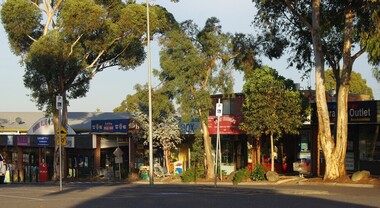
 Greensborough Historical Society
Photograph - Digital image, Marilyn Smith, Diamond Village Shopping Centre, Watsonia, 2016, 22/05/2016
Diamond Village Shopping Centre, Nepean Street Watsonia.Digital copy of colour photograph.diamond village shopping centre, watsonia