Showing 130 items
matching new concrete bridge
-
 Eltham District Historical Society Inc
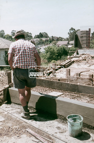
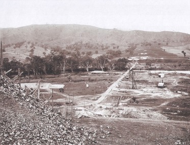
Slide, Sherbourne Road overpass, Briar Hill, Bridge span concrete pour, c.October 1970, 1970
Construction of new realigned Sherbourne Road railway overpass following realignment construction works for intersection of Sherbourne Road and Para Road.35 mm colour positive transparency Mount - Agfacolor Service (Blue)briar hill, bridge construction, overpass, para road, railway bridge, road construction, sherbourne road -
 Eltham District Historical Society Inc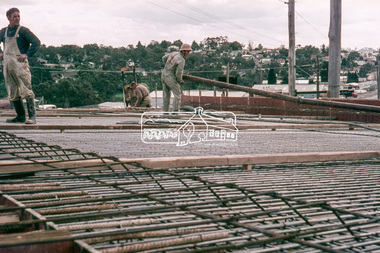
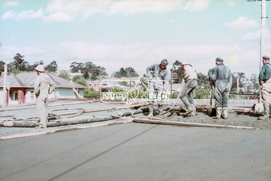
Slide, Sherbourne Road overpass, Briar Hill, Bridge span concrete pour, c.October 1970, 1970
Construction of new realigned Sherbourne Road railway overpass following realignment construction works for intersection of Sherbourne Road and Para Road.35 mm colour positive transparency Mount - Agfacolor Service (Blue)briar hill, bridge construction, overpass, para road, railway bridge, road construction, sherbourne road -
 Phillip Island and District Historical Society Inc.
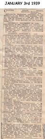
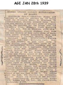
Newspaper clippings, 09/01/1939
Newspaper articleContract to supply concrete to site of a new bridge between San Remo and Newhaven for Country Roads Board.local history, documents, newspapers, bridges, phillip island, black & white newspaper clipping, country roads board -
 Phillip Island and District Historical Society Inc.
Newspaper clippings, 28/01/1939
Newspaper clippingContract to supply of aggregate for concrete to the site of the new bridge at Phillip islandlocal history, documents, newspapers, bridges, phillip island, black & white newspaper clipping, phillip island. -
 Phillip Island and District Historical Society Inc.
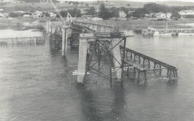
Photograph, Phillip Island Bridge, 1968/9
1969 2nd Phillip Island Bridge under construction. Suspension Bridge demolished early 1970 From the Jack Jenner CollectionConcrete stanchions and scaffolding of new Bridge part built.(opened 1969). Taken from other half looking towards San Remo.local history, photographs, civil engineering, bridges, phillip island bridges, black & white photograph, jack jenner collection, public construction -
 Phillip Island and District Historical Society Inc.
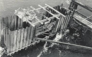
Photograph, Phillip Island Bridge, 1968/9
... Scaffolding for concrete works for new Bridge. Top view... Scaffolding for concrete works for new Bridge. Top view of empty ...Construction of 2nd Phillip Island Bridge. 1969. From the Jack Jenner Collection.Scaffolding for concrete works for new Bridge. Top view of empty forming close-up.local history, photographs, civil engineering, bridges, phillip island bridges, black & white photograph, jack jenner collection, public construction -
 Greensborough Historical Society
Photograph, Main Road bridge looking to township of Greensborough, 1929c
View of Main Street Greensborough from Partington's Hill including Plenty River bridge and Marble Hall on corner of Carter Street (now Para Road) and Main Street. This view of Greensborough Park shows the old pan toilets, the hawthorn fence line and the rather undeveloped roadside area of the park. Looking up Main Street we see the old Chapman house at the corner of Poulter Avenue and some newer houses below this. The stone river bridge appears to be only a single lane wide and the road approaching the bridge is unsealed. The rail bridge shows evidence of soot from steam trains and at the extreme left of picture the two concrete buildings indicate the line had been electrified. This occurred in 1923. Sparse housing is seen in the Flintoff Street and Grimshaw Street area.Part of a collection of photographic enlargements of views of Greensborough in the early 1900s.Black and white enlargement of photographic imagemain street greensborough, marble hall, greensborough railway, chapman house, greensborough park, poulter avenue greensborough, carter street, para road -
 Halls Gap & Grampians Historical Society
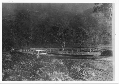
Photograph, C 1911
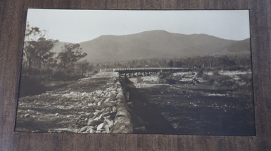
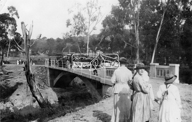
This is the second Delley''s Bridge. A new and more substantial bridge was built in 1911, only to be badly damaged in a 1917 flood. The collapsed western end was rebuilt, this time supported by concrete pillars.The photo shows a dirt road crossing a creek via a wooden bridge. A woman is driving a horse and buggy onto the far end of the bridge. There are ferns in the foreground and trees in the background.access routes, roads, structures, bridges -
 Kiewa Valley Historical Society
Photos - Tawonga Bridge x 2
The first Tawonga bridge was built in 1884. It was destroyed by floods in 1916. The new bridge was constructed in 1923 and destroyed in 1953. The present concrete bridge was constructed in 1986 and named Ryders Bridge. Also refer to ?KVHS 0962 and KVHS 1051, KVHS 1090, KVHS 1123Bridge constructed over the Kiewa River in 1923 and destroyed in 1953.1. Dark Brownish photo framed by thin wood. Photo shows bridge with mountain behind and river and river bank in the foreground. 2. Small photo showing 2 sides of the bridge - a close up view.tawonga bridge, kiewa valley, kiewa river -
 Eltham District Historical Society Inc
Negative - Photograph, Opening of the new bridge at Hurstbridge, 1917
The opening ceremony of new the bridge over the Diamond Creek at Hurstbridge, designed by Sir John Monash. The single arch concrete bride replaced the original wooden structure erected in 1881. People gathering around 3pm for the Official Opening of Hurst's Bridge, 3 November 1917. View of steam train at Hurstbridge Railway Station in distance. Part of a slide show presentation "Bridges & Waterways of the Shire" by Russell Yeoman to the 13 September 1989 Society meeting. The presentation included slides of historic photos from the Shire of Eltham Pioneers collections as well as several recent views. 1917 'HURST'S BRIDGE.', Eltham and Whittlesea Shires Advertiser and Diamond Creek Valley Advocate (Vic. : 1917 - 1922), 9 November, p. 3. (MORNING.), viewed 28 Jul 2018, http://nla.gov.au/nla.news-article57641838This photo forms part of a collection of photographs gathered by the Shire of Eltham for their centenary project book,"Pioneers and Painters: 100 years of the Shire of Eltham" by Alan Marshall (1971). The collection of over 500 images is held in partnership between Eltham District Historical Society and Yarra Plenty Regional Library (Eltham Library) and is now formally known as the 'The Shire of Eltham Pioneers Photograph Collection.' It is significant in being the first community sourced collection representing the places and people of the Shire's first one hundred years.Digital image 120 format B&W negativesepp, shire of eltham pioneers photograph collection, diamond creek, hurstbridge, wattle glen, bridge, mia mia, opening day, sir john monash -
 Ringwood and District Historical Society
Photograph, Concrete culverts for new bridge. Warrandyte Rd. Ringwood 1986 (2 Views)
... Concrete culverts for new bridge. Warrandyte Rd. Ringwood... of Barrett's old garden. Concrete culverts for new bridge. Warrandyte ...Written on back of photograph, "for new bridge. Warrandyte Rd. 1986." SS0369h shows plants of Barrett's old garden. -
 Orbost & District Historical Society
black and white photographs, 1934
These photographs were taken just after the McKillop's Bridge was completed after the flood damage. The current McKillop’s Bridge was built by the Country Roads Board in two stages between 1931-36, during which its height was raised after the original bridge superstructure was washed away in record floods of January 1934, prior to its original official opening. In its reconstructed form the original concrete abutments were turned into additional piers and the welded-steel trusses were cantilevered back over them to meet the new higher road approaches. It is sited at McKillops Crossing, named after pioneer overlanding squatter George McKillop who crossed here in 1835. This was a stock crossing place for almost a century before the bridge was constructed. (info. from Victoria Heritage Register)This is a pictorial record of the history of McKillop's Bridge, in itself of historical significance for its association with Victoria's long and important pastoral history, its technicl significance and aesthetic significance.Three black / white photographs. 3133.1 shows the approach to a washed away bridge. 3133.2 is of a bridge over a river with men clearing debris. 3133.3 is a close-up showing the wreckage of the bridge.mckillop's-bridge snowy-river flood-damage-1934 -
 Orbost & District Historical Society
black and white photograph, mid 1930s
This is a photograph of McKillop's Bridge probably taken just after its rebuilding. The current McKillop’s Bridge was built by the Country Roads Board in two stages between 1931-36, during which its height was raised after the original bridge superstructure was washed away in record floods of January 1934, prior to its original official opening. In its reconstructed form the original concrete abutments were turned into additional piers and the welded-steel trusses were cantilevered back over them to meet the new higher road approaches. "McKillops Bridge was Heritage listed due to its social and technological significance – the steel trusses' arc-welded construction technique was a pretty big deal in the 1930s. It was once an important route for cattlemen, who used the ford across the Snowy in the years preceding the bridge's existence"This is a pictorial record of McKillop's Bridge just after its construction.A black / white photograph of a wooden bridge across a river. At the bottom right is a man with his back to the camera. He is looking at flood debris on the bank. At the bottom left are two men near a pylon.on back - McKillops Bridgebridge-mckillop's snowy-river-bridge -
 Bendigo Historical Society Inc.
Booklet - Engineering Heritage Recognition Ceremony
In 1867, Frenchman Joseph Monier patented the use of metal reinforced concrete for use in horticultural troughs. Francois Hennebique expanded this idea into a general construction technique including for the construction of bridges bridges with the first bridge built in 1875. In Victoria, Monash and Anderson, representatives of the Australian patent holders and later Victorian patent holders. The Bendigo Monier Bridges were built between 1901 and 1902. Monash's contribution was not in the actual technology but in the promotion and defence of the new technology that was faced by much doubt and scepticism.Ten page booklet with a red and white cardboard cover produced for the Engineering Heritage Recognition Ceremony held on 9th August 2014. Includes the story of the Monier Arched Bridges in Bendigo. Includes B&W and coloured photographs. Produced by Engineers Australia.monier, monier bridges, sir john monash, joshua anderson, engineering -
 Bendigo Historical Society Inc.
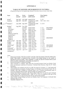
Document - Table of Monier Arch Bridges in Victoria
In 1867, Frenchman Joseph Monier patented the use of metal reinforced concrete for use in horticultural troughs. Francois Hennebique expanded this idea into a general construction technique including for the construction of bridges with the first bridge built in 1875. In Victoria, Monash and Anderson, representatives of the Australian patent holders and later Victorian patent holders. The Bendigo Monier Bridges were built between 1901 and 1902. Monash's contribution was not in the actual technology but in the promotion and defence of the new technology that was faced by much doubt and scepticism.Single A4 sheet, Appendix E, photocopied from "The Monier Bridges of Bendigo" Includes dates and specifications of Victorian Monier Arched Bridges. Prepared by the Dept of Civil Engineering, Monash University. July 1988monier bridges, engineering -
 Bendigo Historical Society Inc.
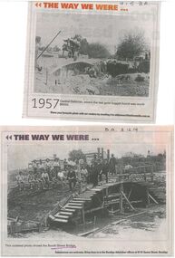
Document - Newspaper Articles from Bendigo Advertiser
In 1867, Frenchman Joseph Monier patented the use of metal reinforced concrete for use in horticultural troughs. Francois Hennebique expanded this idea into a general construction technique including for the construction of bridges bridges with the first bridge built in 1875. In Victoria, Monash and Anderson, representatives of the Australian patent holders and later Victorian patent holders. The Bendigo Monier Bridges were built between 1901 and 1902. Monash's contribution was not in the actual technology but in the promotion and defence of the new technology that was faced by much doubt and scepticism.Series of Bendigo Advertiser articles on the theme of Monier Bridges. Five articles from "Discover Bendigo" by James Lerk. 1999 One article from "History Lives" by Jim Evens titled 'Building History Bridges" 2014 Two black and white photos from "The Way we Were" featuring the construction of the Booth Street Bridge 2014 and the collapse of the King Street bridge 2015.monier bridges, engineering -
 Hume City Civic Collection
Photograph, Early 1970s
In the early 1970s the eastern approach to Sunbury was changed. The stone bridge spanning the Jacksons Creek was replaced by a wider concrete structure and dangerous curves were taken out of the road. The area on the LHS of the photograph including the two arched stone bridge has been incorporated into a public picnic area.A black and white panoramic view of the eastern approach to Sunbury and the Sunbury township before the road was widened and straightened and the new bridge was built. There are two cars in the foreground. One is approaching the bridge and the other is leaving Sunbury.macedon street, macedon street road bridge, jacksons creek, sunbury township, george evans collection -
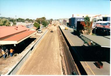 Hume City Civic Collection
Photograph, 21/04/2005
This photograph was taken during the upgrade of the Bendigo Railway line at Sunbury Station.A coloured photograph of construction on the site of the Sunbury Railway Station. The rail track has been lowered and the station platform has been narrowed to accommodate the new trains. The former bluestone wall below the platform on the Melbourne side of the station has been replaced by reinforced concrete. The rail lines have been placed along the track on the RHS of the photograph.railways, bendigo line, railway stations, bridges, sunbury railway station, george evans collection -
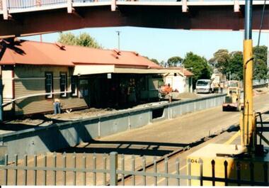 Hume City Civic Collection
Photograph, 21/04/2005
This photograph was taken during the upgrade of the Bendigo Railway line at Sunbury Station. The upgrade took twelve months to complete and during that time buses replaced the trains.A coloured photograph of construction on the site of the Sunbury Railway Station. The photograph was taken from the Bendigo platform and shows the concrete wall which replace the bluestone foundations on the Melbourne side of the station. A workman is on the platform working on the new surface.railways, bendigo line, railway stations, bridges, sunbury railway station, george evans collection -
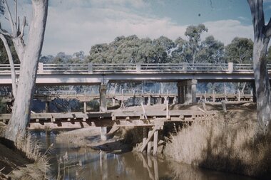
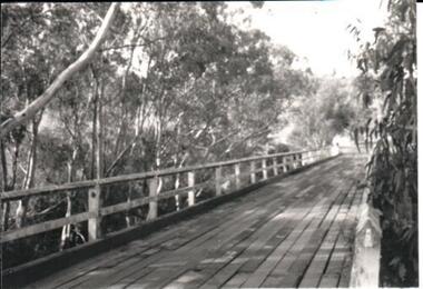 Hume City Civic Collection
Photograph, late 1970s
The photograph was taken before the wooden Holden Bridge which spans an arm of the Deep Creek at Bulla was replaced by a more sunstantial concrete structure. As well as building a new bridge, the sharp bend and approach to the old bridge was also removed.A black and white photograph of a wooden road bridge with eucalypt trees growing on either side of the bridge.bridges, holden bridge, shire of bulla, george evans collection -
 Stawell Historical Society Inc
Slide, Ian McCann, Three Bridges
Three Bridges across a river, two oled wooden ones and the newer concrete one in the centre. at Campbells Bridgebridges, campbells bridge -
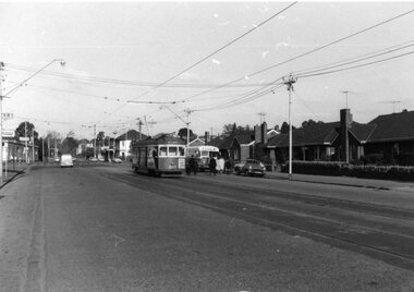 Ballarat Tramway Museum
Photograph - Black & White Photograph/s, mid to Late 1965
Set of seven Black and white photographs of the arrangements and work for the track reconstruction at the intersection of Hoddle St/Punt Rd and Bridge Road Richmond late 1965. On Kodak paper. 1420.1 - Bridge Road looking east at River St. crossover (Hawthorn bridge in distant background). Tram-bus connection at a weekend. Note driver's uniform. Conductor walking to bus with passengers. Conductors often worked through on the bus and next tram at this time to save crews. 1420.2 - Bridge Road at Punt Rd and Hoddle St. intersection looking north west. Reconstruction of curves. Would probably be a Sunday given that new rails are in situ. 1420.3 - Ditto - looking south east 1420.4 - looking south east 1420.5 - looking east - replacement bus service passing with old cable winding house in the background. Concrete being placed. 1420.6 - Wellington Parade at Simpson St. crossover looking east. Bus-tram connection. Bus 542 and tram 966 (Kew Depot) 1420.7 - ditto - bus 570 and tram 850 (Camberwell). See P.Winspur note - see data sheet for Reg. item 1418.trams, tramways, bridge road, tram - bus connections, trackwork, mmtb, tram 939, tram 966, tram 850 -
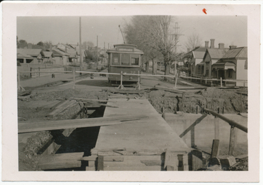 Ballarat Tramway Museum
Photograph - Digital image, Wal Jack, 19/06/1955 12:00:00 AM
... the reconstruction of the bridge. Shows the new concrete base... Pleasant during the reconstruction of the bridge. Shows the new ...Yields information the reconstruction of the Canadian Creek Bridge in 1955.Digital image from the Wal Jack Ballarat Album of No. 32 at Canadian Creek bridge in Barkly St, Mt Pleasant during the reconstruction of the bridge. Shows the new concrete base for the track in position. Photo dated 19-6-55 and shows the reconstruction work in progress. Tram was isolated to enable the service in Barkly St during the reconstruction of the Canadian Creek bridge during June-July 1955, see Reg Item 5155, 5157 as well and 5301, 5302 and 5305 and 7735. See image i2 for rear of photograph. See image i3 for hi res scan of print. See image i4 for hi res scan of negativeOn rear in ink "SEC Ballarat No. 35 east of creek, No. 32 concrete slabs for tram track placed across new box girders, Barkly St Ballarat East 19-6-55." In top right hand corner is Wal Jack stamp with number T179 written in.trams, tramways, mt pleasant, canadian creek, barkly st, bridges, tram 32 -
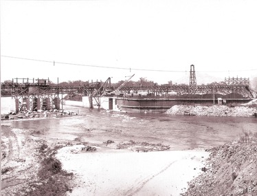
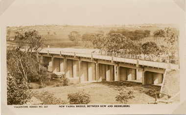 Kew Historical Society Inc
Postcard, Valentine Publishing Co Pty Ltd, New Yarra Bridge, Between Kew and Heidelberg, 1926-1930
Without bridges, Kew remained cut off from the City of Melbourne, only being accessible by Punt. Private and public bridges were constructed from the 1850s, beginning with the Hawthorn Bridge linking Bridge and Burwood Roads. A bridge across the Yarra at Burke Road was created as early as 1873. Since that first wooden bridge, a number of later bridges, typically on concrete pylons have been built, in 1926 and again during the 1970s.Angle view of the new Yarra bridge [ie. The Burke Road bridge] taken from the Kew side, showing the bridge’s structure. Trees line the river’s edge. In the distance can be seen a distant line of houses stretching to the horizon. The river appears to have an S-shaped bend beyond the bridge. The postcard, No. 227, was produced by the Valentine Publishing Co. Pty Ltd., of Queen Street, Melbourne.burke road bridge - kew (vic), bridges - kew (vic) -
 Wodonga & District Historical Society Inc
Album - Hume Reservoir Australia Album - Driving first row of piles for coffer dam across the river, December 1925
This set of photos is from a leather bound album bearing the inscription "HUME RESERVOIR AUSTRALIA" plus 'The Rt. Hon. L. C. M. S. Amery, P. C., M .P.' all inscribed in gold. It was presented to The Rt. Hon. L. C. M. S. Amery, P. C., M. P, Secretary of State for Dominion Affairs on the occasion of his visit to the Hume Reservoir on 2nd November 1927. This album is of local and national significance as it documents the planning and development of the Hume Reservoir up to 1927. It was the largest water reservoir in the British Empire. The album records the pioneering engineering work that went into its construction.DEPARTMENT OF PUBLIC WORKS, N.S.W. RIVER MURRAY WATERS SCHEME. HUME RESERVOIR. 19. Driving first row of piles for coffer dam across the river. New South Wales. December 1925. Cofferdams are temporary structures used where construction is being carried out in areas submerged in water. They are most commonly used to facilitate the construction or repair of dams, piers and bridges. To divert the river, a Coffer Dam was built across the old bed above and below the Dam site and tying into the end of the concrete wall built inside the levee bank. This completely surrounded the remainder of the site of the Dam and south wing wall, including an area of 12½ acres. hume reservoir australia, river murray waters scheme, hume reservoir construction -
 Wodonga & District Historical Society Inc
Album - Hume Reservoir Australia Album - Section of completed coffer dam, January 1927
This set of photos is from a leather bound album bearing the inscription "HUME RESERVOIR AUSTRALIA" plus 'The Rt. Hon. L. C. M. S. Amery, P. C., M .P.' all inscribed in gold. It was presented to The Rt. Hon. L. C. M. S. Amery, P. C., M. P, Secretary of State for Dominion Affairs on the occasion of his visit to the Hume Reservoir on 2nd November 1927. This album is of local and national significance as it documents the planning and development of the Hume Reservoir up to 1927. It was the largest water reservoir in the British Empire. The album records the pioneering engineering work that went into its construction.DEPARTMENT OF PUBLIC WORKS, N.S.W. RIVER MURRAY WATERS SCHEME. HUME RESERVOIR. 20. Section of completed coffer dam with river diverted over the concrete foundations of dam that were placed during the first stage of operations. New South Wales. January 1927. Cofferdams are temporary structures used where construction is being carried out in areas submerged in water. They are most commonly used to facilitate the construction or repair of dams, piers and bridges. To divert the river, a Coffer Dam was built across the old bed above and below the Dam site and tying into the end of the concrete wall built inside the levee bank. This completely surrounded the remainder of the site of the Dam and south wing wall, including an area of 12½ acres. hume reservoir australia, river murray waters scheme, hume reservoir construction -
 Wodonga & District Historical Society Inc
Album - Hume Reservoir Australia Album - Excavations for foundations inside coffer dam, January 1927
This set of photos is from a leather bound album bearing the inscription "HUME RESERVOIR AUSTRALIA" plus 'The Rt. Hon. L. C. M. S. Amery, P. C., M .P.' all inscribed in gold. It was presented to The Rt. Hon. L. C. M. S. Amery, P. C., M. P, Secretary of State for Dominion Affairs on the occasion of his visit to the Hume Reservoir on 2nd November 1927. This album is of local and national significance as it documents the planning and development of the Hume Reservoir up to 1927. It was the largest water reservoir in the British Empire. The album records the pioneering engineering work that went into its construction.DEPARTMENT OF PUBLIC WORKS, N.S.W. RIVER MURRAY WATERS SCHEME. HUME RESERVOIR. 21. Excavations for foundations inside coffer dam. New South Wales. January 1927. Cofferdams are temporary structures used where construction is being carried out in areas submerged in water. They are most commonly used to facilitate the construction or repair of dams, piers and bridges. To divert the river, a Coffer Dam was built across the old bed above and below the Dam site and tying into the end of the concrete wall built inside the levee bank. This completely surrounded the remainder of the site of the Dam and south wing wall, including an area of 12½ acres. hume reservoir australia, river murray waters scheme, hume reservoir construction, coffer dam -
 Wodonga & District Historical Society Inc
Album - Hume Reservoir Australia Album - Bethanga Bridge Site, August 1927
This set of photos is from a leather bound album bearing the inscription "HUME RESERVOIR AUSTRALIA" plus 'The Rt. Hon. L. C. M. S. Amery, P. C., M .P.' all inscribed in gold. It was presented to The Rt. Hon. L. C. M. S. Amery, P. C., M. P, Secretary of State for Dominion Affairs on the occasion of his visit to the Hume Reservoir on 2nd November 1927. This album is of local and national significance as it documents the planning and development of the Hume Reservoir up to 1927. It was the largest water reservoir in the British Empire. The album records the pioneering engineering work that went into its construction.DEPARTMENT OF PUBLIC WORKS, N.S.W. RIVER MURRAY WATERS SCHEME. HUME RESERVOIR. 37. Bethanga Bridge Site. A bridge is being built to cross the Reservoir to serve a large area of country which will be cut off from its natural outlets by the submergence of existing bridges when the Reservoir is in being. The site of the bridge is nearly a mile up the Murray from the Hume Reservoir Quarry. Its length will be approximately half a mile. There will be nine spans of 269 feet with steel truss girders resting on concrete pillars. Some of the pillars are founded on rock while others will rest on nests of reinforced concrete piles. The foundations and concrete piers are in the hands of the Victorian Constructing Authority and the superstructure in those of the New South Wales Authority. August 1927.hume reservoir australia, river murray waters scheme, hume reservoir construction -
 Wodonga & District Historical Society Inc
Photograph - Bethanga Bridge
The Bethanga Bridge was built between 1927 and 1930 as a joint venture between Victoria and New South Wales and was a key element of the River Murray Waters Agreement. It consists of nine spans of 82 metres long. Each span is supported between double reinforced concrete pylons and a riveted steel camel back Pratt truss. The overall span of the bridge is a length of 752 metres. It was completed in 1929 at a cost of £194,000. The road deck was initially constructed from timber but was replaced in 1961 with a concrete waffle slab deck 7.7metres wide. In 1961 the bridge deck and truss structure were raised 300 millimetres to allow for the enlargement of the lake. The bridge was designed in NSW by road engineer Percy Alan and the trusses were built by the Charles Ruwolt Pty. Ltd. Charles Ruwolt Pty. Ltd. was originally established by Charles Ruwolt as a foundry at Wangaratta in 1902 and transferred its operations to Richmond, Melbourne in 1914. By 1938 it had become one of the biggest engineering companies in Australia. After Charles Ruwolt’s death in 1946, Vickers Ltd. acquired the company and in 1948 the firm became known as Vickers Ruwolt Pty. Ltd. Because of the Bethanga Bridge’s unique location, over the waters of a dam with the border running down the centre of the body of water, the Bethanga Bridge is the only built structure shared by both Victoria and New South Wales. As the border of New South Wales aligns with the southern bank of the Murray River all of the other bridges along its length are deemed to be in New South Wales. The Bethanga Bridge is listed on both the New South Wales State Heritage Register and the Victorian Heritage Database. In 2015 the Bethanga Bridge was nominated for a heritage award by the Institution of Engineering Australia.These images are significant because they document the construction of a bridge which links Victoria and New South Wales and has been recognised for its historical, technical and engineering significance.A collection of photos documenting the construction of the Bethanga Bridge which links the States of Victoria and New South Wales as part of the construction of the Hume Dam .bethanga bridge, hume dam constuction, charles ruwolt, percy allan engineer