Showing 1563 items matching "off road"
-
 Eltham District Historical Society Inc
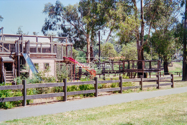
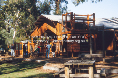
Negative - Photograph, Eltham North Adventure Playground, Wattletree Road, Eltham, 1998c
... to the construction of the Eltham North Adventure Playground which opened off... to the construction of the Eltham North Adventure Playground which opened off ...A community group project steered by Bambi McLean led to the construction of the Eltham North Adventure Playground which opened off Wattletree Road in 1995. The structure was mainly wooden and included an undercover element with slides and areas to climb. It was destroyed by fire in 2017. A new adventure playground was built in 2018.Roll of 35mm colour negative film, 8 strips and associated 10 x 15 cm colour printKodak Gold 100-5north eltham, north eltham adventure playground, wattletree road -
 Eltham District Historical Society Inc
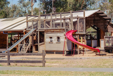
Negative - Photograph, Eltham North Adventure Playground, Wattletree Road, Eltham, 1998c
... to the construction of the Eltham North Adventure Playground which opened off... to the construction of the Eltham North Adventure Playground which opened off ...A community group project steered by Bambi McLean led to the construction of the Eltham North Adventure Playground which opened off Wattletree Road in 1995. The structure was mainly wooden and included an undercover element with slides and areas to climb. It was destroyed by fire in 2017. A new adventure playground was built in 2018.Roll of 35mm colour negative film, 8 strips and associated 10 x 15 cm colour printKodak Gold 100-5north eltham, north eltham adventure playground, wattletree road -
 Ballarat Tramway Museum
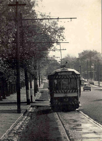
Photograph - Black & White Photograph/s, Peter Bruce, c1970
... a shower of rain, giving reflections of the sun light off the road... light off the road surface. Photograph Black & White Photograph ...Black and white photograph of SEC Ballarat No. 43 travelling along the north side of Sturt St., just past the intersection of Talbot St. Tram has destination of "Mt PLEASANT". Telephoto lens photograph, with sun behind tramcar, and just after a shower of rain, giving reflections of the sun light off the road surface.trams, tramways, ballarat, sturt st., mt pleasant , tram 43 -
 Bendigo Historical Society Inc.
Photograph - PHOTOGRAPH. TRAIN ENGINE. 1960. LISMORE, VICTORIA, 11th Feb. 1960
... train engine 'T' 349 having her near bogie off the road... off the road. At Lismore 11/2/60. Photograph PHOTOGRAPH. TRAIN ...Sepia photograph. Train engine with one carriage. Other carriages on other train track. Written on back 'R 720 Tender 1st pulls away the 9.20am 'down' Ararat from Lismore to D'allum a/c train engine 'T' 349 having her near bogie off the road. At Lismore 11/2/60.NORMAN W DE POMEROY.place, train, engine, photograph. train engine. lismore victoria. 11.2.1960 -
 Bendigo Historical Society Inc.
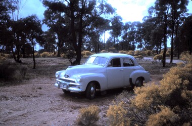
Slide - PETER ELLIS COLLECTION: SLIDE, May 1970 - Jan 1972
... in a bush setting off a road. The car is a light coloured FJ Holden... in a bush setting off a road. The car is a light coloured FJ Holden ...Coloured slide transparency. Image is of a car parked in a bush setting off a road. The car is a light coloured FJ Holden and is parked on dirt amongst low scrub and trees in the background. The words The car used to map the Whipstick are handwritten along the top border and the words The Whipstick Car Aug 31st 1974 are handwritten along the bottom border.Kodachrome Transparencyslide, bendigo, bendigo institute of technology -
 Whitehorse Historical Society Inc.
Document, Forest Hill new home sites, 1/02/1995 12:00:00 AM
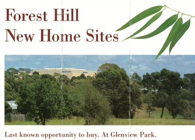
... Brochure advertising 22 new home sites off Glen Valley Road...Whitehorse Historical Society Inc. 2-10 Deep Creek Road ...Advertising 22 new home sites off Glen Valley Road, near the corner of Springvale and Canterbury Roads, Forest HillBrochure advertising 22 new home sites off Glen Valley Road, near the corner of Springvale and Canterbury Roads, Forest Hill on the former Forest Hill Primary School site (closed 1993).Advertising 22 new home sites off Glen Valley Road, near the corner of Springvale and Canterbury Roads, Forest Hillland subdivision, glenview park, glen valley road, forest hill, pratico court, springvale road, fletcher and parker, forest hill primary school -
 Bendigo Historical Society Inc.
Photograph - LONG GULLY HISTORY GROUP COLLECTION: DON MINE & LONG GULLY STATE SCHOOL
... to the New Carshalton Mine off Sparrowhawk Road, Long Gully. Dorrie... was the manager. this is the Don Mine off Top end Sparrowhawk Road, Long ...Copy of a black and white photo of the Don Mine, approx 1934. Written above the photo is - This mine is similar to the New Carshalton Mine off Sparrowhawk Road, Long Gully. Dorrie Crossley's Father Ben Williams was the manager. this is the Don Mine off Top end Sparrowhawk Road, Long Gully. Date above the photo January 7, 1997. Photo (not a very clear one) shows the poppet legs, chimney and some buildings. Below is a photo of the 1 & 2 Class children from the Long Gully State SChool 1933. The children are sitting or standing in front of a brick building.bendigo, history, long gully history group, the long gully history group - don mine, new carshalton mine, dorrie crossley, ben williams, long gully state school photo 1933 -
 Eltham District Historical Society Inc
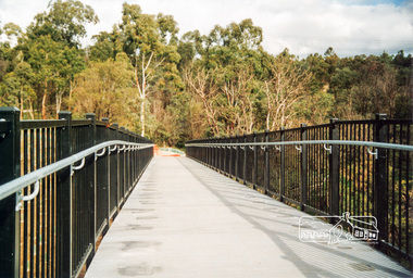
Photograph, Doug Orford, Completion of bridge works across Yarra River at rear of Eltham Lower Park, July 2004, July 2004
... River off Homestead Road, Eltham which was completed in July... River off Homestead Road, Eltham which was completed in July ...Brand new Eltham-Templestowe footbridge over the Yarra River off Homestead Road, Eltham which was completed in July 2004. The Yarra River Footbridge was opened in August 2004 and links the Diamond Creek Trail between the Shire of Nillumbik and City of Manningham. It is a shared pathway and also links with the Main Yarra Trail. It affords lovely views over the Yarra River.One of three colour photographs.yarra river, eltham south, eltham lower park, lenister farm, homestead road, shared pathway, diamond creek trail, footbridge -
 Eltham District Historical Society Inc
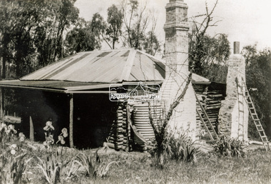
Photograph - Black and White Print, Old settler's cottage, Floods Lane, North Warrandyte, c.1935
... Road off Kangaroo Ground-Warrandyte Rd near boundary of North... Road off Kangaroo Ground-Warrandyte Rd near boundary of North ...An early settler's cottage of 1920s vintage near Floods Rd taken in the 1930s. Was originally Floods Lane and became Floods Road off Kangaroo Ground-Warrandyte Rd near boundary of North WarrandyteInscribed in pencil on reverse "early 20's near Flood Rd taken 30's. 21/1.89" and in pen ".16/1.80"cottage, floods lane, floods road, houses, kangaroo ground-warrandyte road, north warrandyte, pioneers -
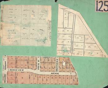 Ringwood and District Historical Society
Card, Collage of Residential Subdivision Map Clippings - Ringwood, Victoria - (Undated)
... of residential allotments off Warrandyte Road in Milne Road and Berringa... of residential allotments off Warrandyte Road in Milne Road and Berringa ...Three maps mounted on green cardboard - Hand-drawn map of residential allotments off Warrandyte Road in Milne Road and Berringa Road Park Orchards. Map with acres roods and perches measurements of allotments in Canterbury Road and Miller Street Heathmont. Clipping from a land sale brochure with street names not existing together in the area - Rangeview Avenue, Press Avenue and Mountview Avenue. -
Glen Eira Historical Society
Document - Goe, Field Flowers, Bishop
... Flowers and Goe Street names off Bambra Road, South of Glenhuntly...). Field Flowers and Goe Street names off Bambra Road, South ...Three items about this Bishop of Melbourne and his connection to Caulfield: An article taken from Australian Dictionary of Biography v.9 1891-1939 on Field Flowers Goe (1832-1910). Field Flowers and Goe Street names off Bambra Road, South of Glenhuntly Road. Handwritten document researched by M. Dunbar 12/03/2013 taken from Sand, Swamp and Heath.goe field flowers, priest, caulfield historical society, field street, flowers street, goe street, bambra road, glenhuntly road, sand swamp and heath, goe emma, rodgers emma, anglican church -
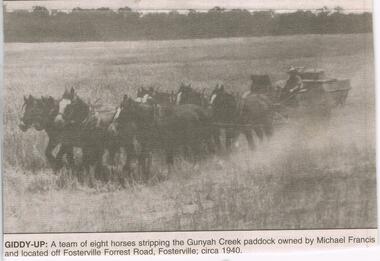 Bendigo Historical Society Inc.
Newspaper - JENNY FOLEY COLLECTION: GIDDY-UP
... by Michael Francis and located off Fosterville Forrest Road... Francis and located off Fosterville Forrest Road, Fostervill ...BHS CollectionBendigo Advertiser ''The way we were'' from 2003. Giddy-up: a team of eight horses stripping the Gunyah Creek paddaco owned by Michael Francis and located off Fosterville Forrest Road, Fostervill; circa 1940. The clip is in a folder.newspaper, bendigo advertiser, the way we were -
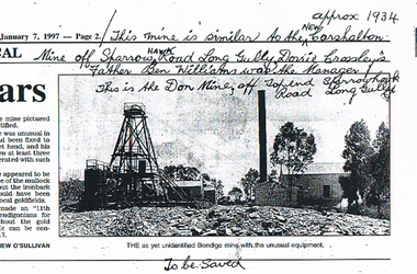 Bendigo Historical Society Inc.
Newspaper - LONG GULLY HISTORY GROUP COLLECTION: THE DON MINE
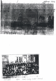
... Mine Approx 1934 off Sparrow Hawk Road Long Gully. Dorrie... is: This mine is similar to the New Carshalton Mine Approx 1934 off ...BHS CollectionCopy of a newspaper article dated 7/1/1997. Photo shows a photo of a mine. Printed under the photo is: The as yet unidentified Bendigo mine with the unusual equipment. In the photo is the poppet head, chimney, buildings and some gum trees. Written at the top of article is: This mine is similar to the New Carshalton Mine Approx 1934 off Sparrow Hawk Road Long Gully. Dorrie Crossley's Father Ben Williams was the Manager. This is the Don Mine, off Top end Sparrowhawk Road Long Gully.bendigo, history, long gully history group, the long gully history group - the don mine, carshalton mine, dorrie crossley, ben williams, matthew o'sullivan -
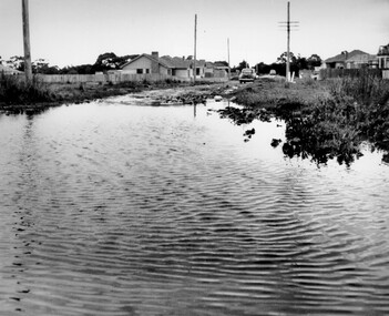 City of Kingston
Photograph - Black and white, c. 1958
... in Beaumaris, located off Balcombe Road. Roads in the Beaumaris area... in Beaumaris, located off Balcombe Road. Roads in the Beaumaris area ...This photograph depicts flooding of Ozone Avenue in Beaumaris, located off Balcombe Road. Roads in the Beaumaris area lacked sufficient drains to clear surface water. In many cases streets were unsealed and without footpaths and some were dirt tracks. Gutters and road surfaces were made of clay and in the wetter months of winter, unsealed roads and tracks became impossible quagmires that were unnavigable for vehicles and pedestrians. In the first decade after World War II there was rapid expansion in construction of new houses in the suburb of Beaumaris. Utilities and infrastructure to support the growth of housing was inadequate and not provided for prior to the development of the area. Without rudimentary drainage, flooding was frequent. Storm water runoff, domestic sullage and septic tank overflow would form large pools and families were sometimes marooned within their homes. The frequent flooding caused isolation and hardship and residents endured difficulties with accessibility to facilities. These disadvantages had the potential to cause social issues for the new residents.Black and white photograph of flooding in Ozone Avenue, Beaumaris. The image shows floodwaters with boggy and rough terrain on an unsealed road with housing in the distance.Handwritten in blue ink: 2124 circled Handwritten in red ink: 80% Handwritten in blue ink on yellow Post-It note: Chap 6. underlined, 2194 Ozone Ave Beaumaris 1958beaumaris, ozone avenue, balcombe road, flooding, roads, infrastructure -
Glen Eira Historical Society
Letter - MEMORIES GLEN EIRA ROAD
... off Orrong Road in 1911 Sands and McDougall directory.... Barton on street names and residents off Orrong Road in 1911 ...2 items: 1/A ten page handwritten letter from Mrs. C.R. Biesse on 12/12/1976 to Mr. Murray. The letter gives her memories of the area around Judge Hood’s Estate, related to her by an elderly acquaintance and her grandfather. Includes a small handdrawn map. 2/Handwritten research by Claire Barton on street names and residents off Orrong Road in 1911 Sands and McDougall directory.biesse c.r. mrs., merton street, caulfiled north, judge hood, hood crescent, droving, judge hood’s estate, land subdivision, judge stephens, st. mary’s church, otira road, helenslea road, shelford, landscapes, kerr b. mrs., palmer florence mrs., morrice street, glen eira road, kambea grove, bushland, cattle, mitchell mr. builder, palmer florence, mitchell colin, mitchell clive, mitchell francis, mitchell mrs., perry family, orrong road, st. aubins ave., ‘orotava’, hayes g.h., ‘kambea’, lothian henry, oswald j.d., ‘merton’, glen eira road -
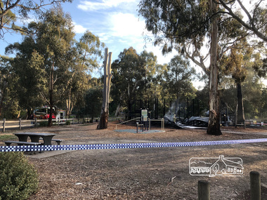 Eltham District Historical Society Inc
Photograph, Vicki Ward, Day breaks over the destroyed Adventure Playground at Eltham North, 16 December 2017
... to the construction of the Eltham North Adventure Playground which opened off... to the construction of the Eltham North Adventure Playground which opened off ...A community group project steered by Bambi McLean led to the construction of the Eltham North Adventure Playground which opened off Wattletree Road in 1995. The structure was mainly wooden and included an undercover element with slides and areas to climb. It was destroyed by fire in the early hours of 16 December 2017. These phtoos of the aftermath were taken at approx. 6:45am in the morning by Vicki Ward, MP for Eltham A new adventure playground was built in 2018. Digital fileeltham north, north eltham adventure playground, arson, wattletree road -
 Eltham District Historical Society Inc
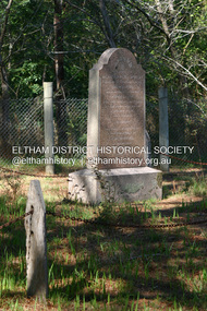
Photograph - Digital Photograph, Alan King, Henry Hurst grave, 1 February 2008
... , by Greysharps Road off Arthurs Creek Road erected ‘by a grateful public..., by Greysharps Road off Arthurs Creek Road erected ‘by a grateful public ...Henry Hurst, after whom Hurstbridge was named, had a hard and adventurous life in the raw colony of the mid 1800s. His tragic end is recounted on his tombstone at the Hurst family cemetery, by Greysharps Road off Arthurs Creek Road erected ‘by a grateful public as a memorial to his heroic self-sacrifice.’ The memorial reads, ‘Sacred to the memory of Henry Facey Hurst (formerly of Hanford Dorset) who while defending his home fell near this spot by a ball fired by the bushranger Burke on October 4 1866 aged 34 years’. Published: Nillumbik Now and Then / Marguerite Marshall 2008; photographs Alan King with Marguerite Marshall.; p15This collection of almost 130 photos about places and people within the Shire of Nillumbik, an urban and rural municipality in Melbourne's north, contributes to an understanding of the history of the Shire. Published in 2008 immediately prior to the Black Saturday bushfires of February 7, 2009, it documents sites that were impacted, and in some cases destroyed by the fires. It includes photographs taken especially for the publication, creating a unique time capsule representing the Shire in the early 21st century. It remains the most recent comprehenesive publication devoted to the Shire's history connecting local residents to the past. nillumbik now and then (marshall-king) collection, hurst family cemetery, hurstbridge, gravestones, henry hurst, memorial -
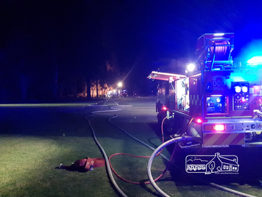 Eltham District Historical Society Inc
Photograph, Anthony Owen, Arson fire in early hours of the morning destroys the Adventure Playground at Eltham North, 16 December 2017
... to the construction of the Eltham North Adventure Playground which opened off... to the construction of the Eltham North Adventure Playground which opened off ...A community group project steered by Bambi McLean led to the construction of the Eltham North Adventure Playground which opened off Wattletree Road in 1995. The structure was mainly wooden and included an undercover element with slides and areas to climb. It was destroyed by fire in the early hours of 16 December 2017. These phtoos were taken at approx. 2am on the morning of 16 December 2017 by 2nd Lieutenant Anthony Owen of Eltham Fire Station. A new adventure playground was built in 2018.Digital fileeltham north, north eltham adventure playground, arson, wattletree road, fire engine, eltham fire brigade, eltham fire station, eltham cfa -
 Ringwood and District Historical Society
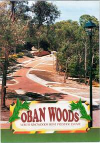
Document - Land Sale Folder, Oban Woods Subdivision, Ringwood North, Vic., - circa 1997
... Estate off Oban Road and Kubis Drive, Ringwood North. Agents... Estate off Oban Road and Kubis Drive, Ringwood North. Agents ...Folder containing multi-fold colour pamphlet advertising Lots 6 to 12 of Oban Woods Estate with location map and summary of subdivision features. A4 size attachments include subdivision layout of Lots 2 to 25 with summary of property sizes and undated indications of whether sold or still available at the time, with price where known. Dates not documented however early sales within the development took place around 1997.Estate plan includes Oban Woods (thoroughfare) and Chifley Parade. Location map of area shows development site of Oban Woods Estate off Oban Road and Kubis Drive, Ringwood North. Agents - R.E. Appleby Ringwood Pty Ltd., 170 Warrandyte Road Ringwood North 3134, Telephone 9876 4222, Fax 9876 4209. -
 Eltham District Historical Society Inc
Slide - Photograph, Adventure Playground, Wattletree Road, Eltham North, c.Nov. 2001
... Adventure Playground which opened off Wattletree Road in 1995... Adventure Playground which opened off Wattletree Road in 1995 ...Part of a slide show presentation "A Trip Down the Diamond Creek" by Russell Yeoman to the Eltham District Historical Society meeting of 14 Nov. 2001 A community group project steered by Bambi McLean led to the construction of the Eltham North Adventure Playground which opened off Wattletree Road in 1995. The structure was mainly wooden and included an undercover element with slides and areas to climb. It was destroyed by fire in the early hours of 16 December 2017. A new adventure playground was built in 2018. 35mm colour positive transparency Mount - Black and Whiteadventure playground, eltham north, wattletree road -
 Ringwood and District Historical Society
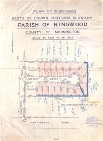
Map - Plan of Subdivision, Parts of Crown Portions 10 and 10B Parish of Ringwood - 1958
... in McKay Court Ringwood, off Wantirna Road north of Canterbury Road... in McKay Court Ringwood, off Wantirna Road north of Canterbury Road ...Folded subdivision map of 15 residential allotments in McKay Court Ringwood, off Wantirna Road north of Canterbury Road. Rubber stamped by Surveyors and Chartered Engineers J.S. Watson & Associates, Mornington and South Yarra, with illegible signature dated 17/2/58. Handwritten notations indicating allotment sale names and amounts or where passed in. Accompanying clipping on scrap paper backing from Land Sale Brochure with description of available services and local facilities and terms of sale - £75 Deposit £10 Monthly. -
 Glen Eira Historical Society
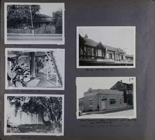
Album - Album page, Hawthorn Road, Circa 1972
... HAWTHORN RD / WEST SIDE - SOUTH OFF BALACLAVA ROAD [under bottom... / WEST SIDE - SOUTH OFF BALACLAVA ROAD [under bottom right photo ...This photograph is part of the Caulfield Historical Album 1972. This album was created in approximately 1972 as part of a project by the Caulfield Historical Society to assist in identifying buildings worthy of preservation. The album is related to a Survey the Caulfield Historical Society developed in collaboration with the National Trust of Australia (Victoria) and Caulfield City Council to identify historic buildings within the City of Caulfield that warranted the protection of a National Trust Classification. Principal photographer thought to be Trevor Hart, member of Caulfield Historical Society. Most photographs were taken between 1966-1972 with a small number of photographs being older and from unknown sources. All photographs are black and white except where stated, with 386 photographs over 198 pages. 17 Hawthorn Road, North Caulfield is a contributory building to HO14 Caulfield North and environs, Caulfield North - Heritage Precinct in the City of Glen Eira.Page 83 of Photograph Album with five portrait photographs of 3 different properties on Hawthorn Road. Addresses are handwritten underneath each property.Handwritten: 17 HAWTHORN ROAD [under top left photo] / 17 HAWTHORN ROAD [under middle left photo] / 17 HAWTHORN ROAD [under bottom left photo] / 158-162 HAWTHORN ROAD [under top right photo] // STATE SAVINGS BANK CAULFIELD WEST BRANCH / 144 HAWTHORN RD / WEST SIDE - SOUTH OFF BALACLAVA ROAD [under bottom right photo] / 83 [bottom left] trevor hart, caulfield, hawthorn road, verandahs, houses, shops, banks, state savings bank, caulfield west, caulfield north, tudor style, victorian style -
 Ringwood and District Historical Society
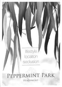
Flyer, Residential Land Sale Brochure, Peppermint Park, Heathmont, Vic. - 2010
... and Barbara Court off Culverlands Road and Armstrong Road in Heathmont... and Barbara Court off Culverlands Road and Armstrong Road in Heathmont ...Double-sided A3 size advertisement for Peppermint Park, Heathmont, Victoria, advertising sale of ten homesites with diagram showing locality map, size of blocks and layout of streets within and around the subdivision.Subdivision layout includes Pleasant Drive, Swain Court and Barbara Court off Culverlands Road and Armstrong Road in Heathmont. Agents - Carter Real Estate Agency, 90 Maroondah Highway, Ringwood Vic 3134 (Telephone) 98706211. Auctioneers - Richard Carter & William Lyall - 0411823337. Handwritten price list notations included, and Stage 2 Plan digitally signed by Michael Herwald Hipfel, Licensed Surveyor, 10/2/1916. -
 Ringwood and District Historical Society
Document - Land Sale Folder, Auburn Grove Estate Ringwood East - 2011-2013
... Estate plan includes Auburn Grove off Longview Road...Estate plan includes Auburn Grove off Longview Road ...Folder containing flyers and multi-fold colour pamphlet advertising Auburn Grove Estate with maps and layout of subdivision and photographs of area. Flyers for First Release Auction 6 August, 2011 enclosed, and Second and Final Release Private Sale flyer with copy showing handwritten sale prices.Estate plan includes Auburn Grove off Longview Road and adjoining Tintern Grammar School, Ringwood East, Vic. Agents - Carter Real Estate, 90 Maroondah Highway, Ringwood Vic 3134. Phone 9870 6211 Fax 9870 6024. Accompanying folder includes handwritten auctioneer's notation (Richard Carter) on the name, that Auburn Grove Estate is adjacent to Tintern Farm - Tintern School originally having moved to Ringwood East from Auburn, Melbourne (1953). -
 Ballarat Tramway Museum
Photograph - Digital image, Wal Jack, 29/03/1956 12:00:00 AM
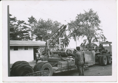
... crane, lifting No. 1 end bogie off Yellow Express Road transport... No. 1 end bogie off Yellow Express Road transport, (No. 40 ex ...Yields information about how bogie trams were transported to Ballarat from Geelong and then received into the depot and offloading the bogies.Digital image from the Wal Jack Ballarat Album of photographs of Geelong No. 40 bogies being off loaded by Yellow Express Crane from the delivery truck in the depot yard, Wal Jack photo 29-3-1956. Became Ballarat No. 43 - see Reg Item 5345 and 7786 also. . See image i2 for rear of photograph. See image i3 for hi res scan of print. See image i4 for hi res scan of negative On rear in blue ink "SEC Ballarat No. Yellow Express No. 10 crane, lifting No. 1 end bogie off Yellow Express Road transport, (No. 40 ex Geelong) Wendouree depot 29-3-56" with Wal Jack stamp in top right hand corner with number "T231" written in.trams, tramways, delivery of tramcars, bogie trams, depot, tram 40, tram 43 -
 Ballarat Tramway Museum
Slide - Set of 10 - COTMA 2000 Visit to BTM, David Verrier, 22-11-2000
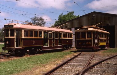
... flag displayed 10 - Tram 18 off the road... - Tram 18 off the road Demonstrates part of the BTM fleet ...Set of nine slides taken during the 2000 COTMA Conference visit to the Ballarat Tramway Museum depot on 22-11-2022 1 - not used 2 - 661 and 26 on depot fan 3 - Trams 26 and 38 on depot fan 4 - Tram 661 in Wendouree Parade and 40 on access track. 5 - Tram 671 in Wendouree Parade near depot junction. 6 - Tram 671 in Wendouree Parade near depot junction. 7 - Tram 661 in Wendouree Parade near depot junction. 8 - Trams 661 and 671 at depot junction 9 - Tram 661 running into the depot access track with red flag displayed 10 - Tram 18 off the roadDemonstrates part of the BTM fleet and operations during the COTMA visit,Set of nine Kodak colour slides - white plastic mountEach slide has details written on it.ballarat, specials, cotma, btm depot, tram 26, tram 671, tram 661, wendouree parade, tram 38, tram 40 -
 Lakes Entrance Historical Society
Photograph - Nyerimilang, 1999
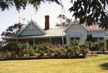
... view, including rose garden. Situated off Kalimna West Road... rose garden. Situated off Kalimna West Road, Nungurner ...Nyerimilang Homestead is in public ownership, managed by Parks Victoria.Colour photograph of Nyerimilang Homestead showing front view, including rose garden. Situated off Kalimna West Road, Nungurner, it is a large white painted timber homestead, corrugated iron roof of hips and gables, painted green, five internal brick chimneys. Situated above the lake with views of Fraser Island and Flannagan Island, outer barrier and distant ocean. Nungurner Victoriahistoric buildings, local history -
 Bendigo Historical Society Inc.
Photograph - Aerial View Sydenham Gardens Estate Circa 1972
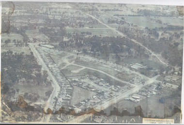
... . It was situated off Holdsworth Road in what is now Jackass Flat. T O.... It was situated off Holdsworth Road in what is now Jackass Flat. T O ...The Sydenham gardens were set up in 1854 to provide an area of relaxation for diggers. A German, Mr Kraemer, made extensive plantings of ornamentals and fruit trees. The area expanded to 11 acres in 1865 and 25 acres in 1916. T O Hunter owned the gardens from about 1896 and initially it was used for many types of entertainment including, picnics, festivals and sporting events. It was situated off Holdsworth Road in what is now Jackass Flat. T O Hunter was a cordial manufacturer in Macrae Street, who was prominent in many sporting areas. He was President of the Bendigo Coursing Association and raced both dogs and horses. By the time he sold the gardens in 1936 to Mr Muir, he was using the gardens as grazing for his horses.Photograph: aerial view of Sydenham Gardens Estate Circa 1972 , as noted on photo Colour photo, A5 sizephoto sydenham gardens estate, aerial photo -
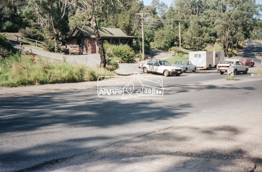 Eltham District Historical Society Inc
Negative - Photograph, Intersection of Mt Pleasant Road at Main Road, Eltham, c.Dec. 1983
... driveway to properties 622-642 Main Road with access off Mount... driveway to properties 622-642 Main Road with access off Mount ...Reconstruction work was planned for Main Road to install a roundabout at Mount Pleasant Road. Traffic to Lower Plenty and Templestowe to be diverted down Bridge Street (and Bolton Street) effective January 1984. The proposed roundabout did not proceed. Instead traffic islands on Mount Pleasant Road were installed in place of temporary blocked out islands and revised extended driveway to properties 622-642 Main Road with access off Mount Pleasant Road instead.Film - Kodak CM 400 5079 7 strips, 26 framesinfrastructure, roads, road construction, roundabout, road sign, main road, mount pleasant road, eltham -
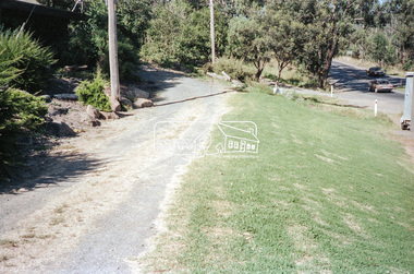 Eltham District Historical Society Inc
Negative - Photograph, Intersection of Mt Pleasant Road at Main Road, Eltham, c.Dec. 1983
... driveway to properties 622-642 Main Road with access off Mount... driveway to properties 622-642 Main Road with access off Mount ...Reconstruction work was planned for Main Road to install a roundabout at Mount Pleasant Road. Traffic to Lower Plenty and Templestowe to be diverted down Bridge Street (and Bolton Street) effective January 1984. The proposed roundabout did not proceed. Instead traffic islands on Mount Pleasant Road were installed in place of temporary blocked out islands and revised extended driveway to properties 622-642 Main Road with access off Mount Pleasant Road instead.Film - Kodak CM 400 5079 7 strips, 26 framesinfrastructure, roads, road construction, roundabout, road sign, main road, mount pleasant road, eltham