Showing 282 items matching "park street (kew)"
-
 Kew Historical Society Inc
Photograph, J F C Farquhar, Dight's Falls, 1891
At the beginning of the 1890s, the Kew businessman and Town Councillor, Henry Kellett, commissioned J.F.C. Farquhar to photograph scenes of Kew. These scenes included panoramas as well as pastoral scenes. The resulting set of twelve photographs was assembled in an album, Kew Where We Live, from which customers could select images for purchase.The preamble to the album describes that the photographs used the ‘argentic bromide’ process, now more commonly known as the gelatine silver process. This form of dry plate photography allowed for the negatives to be kept for weeks before processing, hence its value in landscape photography. The resulting images were considered to be finely grained and everlasting. Evidence of the success of Henry Kellett’s venture can be seen today, in that some of the photographs are held in national collections.It is believed that the Kew Historical Society’s copy of the Kellett album is unique and that the photographs in the book were the first copies taken from the original plates. It is the first and most important series of images produced about Kew. The individual images have proved essential in identifying buildings and places of heritage value in the district.Dight’s Falls in Studley Park is an artificial weir built on a natural rock bar across the Yarra. The weir was built in the 1840s to provide water to the ‘Ceres’ flour mill, one of the earliest industrial sites in Melbourne. The falls were later to be named after the owner of this mill. In 1888, William Guilfoyle, Director of the Melbourne Botanical Gardens had called for fresh water to be piped from above the weir to the Botanical Gardens, using a pumping station on the Kew side of the Falls, a holding reservoir in Walmer Street and a series of pipes from there to the Gardens. This system was opened in May 1891. Farquhar’s photograph of the man-made weir obscures the industrial activity on both sides of the Falls and focusses solely on the river and the surrounding natural vegetation. The photograph probably predates the disastrous flooding of the Yarra River in July 1891, the greatest to have occurred in the Colony since the foundation of Melbourne.Dight's Fallskew illustrated, kew where we live, photographic books, henry kellett, yarra river -
 Kew Historical Society Inc
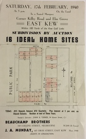
Plan - Subdivision Plan, Subdivision by Auction: 16 Ideal Home Sites, East Kew, 1940, 1940
An advertisement for the sale of a subdivision by Auction: of 16 Ideal Home Sites, East Kew, 1940. This significant sale of land between the Kew Golf Course and Willsmere Park led to the streets having a high degree of architectural uniformity.The subdivision in the second year of the war indicates that land sales for homes and speculation continued from the 1930s into the period of the Second World War. There is no indication on the plan that a war is occurring.Single page subdivision plan advertising the sale by Auction of 16 Ideal Home Sites, in East Kew, on 17 February 1940. Streets named in the plan include: Kilby Road, Belford Road, Elm Grove, Willow Grove. Willsmere Park is indicated but not named. The auction was conducted by Beauchamp Brothers. A number of lots are coloured pink on the plan indicating those lots for sale and/or those already sold.subdivision plans - kew east (vic) -
 Kew Historical Society Inc
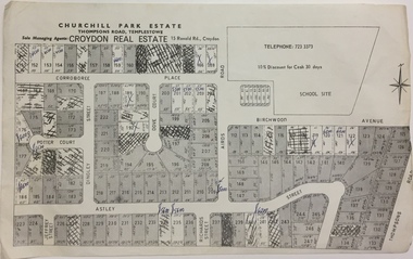
Plan - Subdivision Plan, Churchill Park Estate, Templestowe
Historic subdivision plan of the Churchill Park Estate in Templestowe.Undated subdivision plan advertising the Churchill Park Estate inTemplestowe. Streets identified in the plan include: Corroboree Place, Astley Street, Jeffrey Street, Airds Road, Dove Court, Potter Court, Thompsons Road, Richards Street, and Birchwood Avenue.Annotations in ink on the plan by agentsubdivision plans - templestowe (vic), churchill park estate - templestowe (vic) -
 Kew Historical Society Inc
Plan - Subdivision Plan, Churchill Park Estate, Templestowe
Historic subdivision plan of the Churchill Park Estate in Templestowe.Undated subdivision plan advertising the Churchill Park Estate inTemplestowe. Streets identified in the plan include: Corroboree Place, Astley Street, Jeffrey Street, Airds Road, Dove Court, Potter Court, Thompsons Road, Richards Street, and Birchwood Avenue. This record includes a copy of the price list.Annotations in ink on the plan by agentsubdivision plans - templestowe (vic), churchill park estate - templestowe (vic) -
 Kew Historical Society Inc
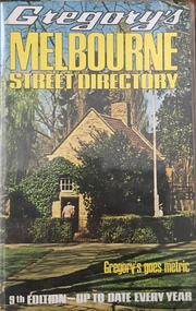
Book, Gregory's Publishing Company Pty Ltd, Gregory's Street Directory of Melbourne and suburbs and Metropolitan Road Guide, 1971
Street DirectoryRevised edition of Gregory's Directory including a series of road maps of Melbourne and its suburbs, newly extending to Lilydale, Mornington, Laverton, Deer Park, Epping, Diamond Creek, Olinda, Belgrave, and Doveton.non-fictionStreet Directorystreet directories - melbourne, gregory's street directories -
 Kew Historical Society Inc
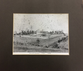
Photograph, 'Hallatrow', Holroyd Street, Kew, 1886, 1886
An important early photograph of a significant Kew mansion - Hallatrow - dating from 1886, soon after it was constructed.What appears to be a reprint of an earlier photograph of Hallatrow, now mounted, originally listed as A'Beckett Street West or Conran Street, but now 6 Holroyd Street in Studley Park. The photograph was originally taken when the house was occupied by the family of Thomas Brodribb. Pencil: “Hallatrow, Kew, 1886” hallatrow - 6 holroyd street - kew )vic), historic buidlings - studley park - kew (vic) -
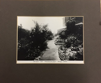 Kew Historical Society Inc
Photograph, Snow at Hallatrow, Aug 1899, 1899
An important early photograph of a significant Kew mansion - Hallatrow - dating from 1899.What appears to be a reprint of an earlier photograph of Hallatrow, now mounted, originally listed as A'Beckett Street West or Conran Street, but now 6 Holroyd Street in Studley Park. The photograph was originally taken when the house was occupied by the family of Thomas Brodribb. Pencil: “Snow at Hallatrow, Aug 1899” hallatrow - 6 holroyd street - kew )vic), historic buidlings - studley park - kew (vic) -
![Toast 25-5-1986 [Hallatrow]](/media/collectors/550653872162f11fb04854aa/items/5e3037ba21ea6717786eae87/item-media/5e3038b121ea6717786f92e1/item-fit-380x285.jpg) Kew Historical Society Inc
Kew Historical Society IncDocument, Toast 25-5-1986 [Hallatrow], 1986
Hallatrow is located at 6 Holroyd Street Kew. It was the home of Thomas Brodribb. The notes were written by his descendant and recall his family's occupation of the house.A manuscript, written by Jim Brodribb, the grandson of Thomas Brodribb, the original owner of Hallatrow, recalling his family's years at Hallatrow (now 6 Holroyd Street in Studley Park.) hallatrow - 6 holroyd street - kew )vic), historic buidlings - studley park - kew (vic) -
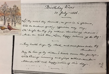 Kew Historical Society Inc
Document - Document [copy], Birthday Verses, 31 July 1886, 1886
Hallatrow was the home of Thomas Brodribb. The house is located at 6 Holroyd Street.2 page copy of birthday verses written by Thomas Brodribb of Hallatrow, 6 Holroyd Street, Studley Park in 1886. The verses celebrate his wife Emily. hallatrow - 6 holroyd street - kew )vic), historic buidlings - studley park - kew (vic) -
 Kew Historical Society Inc
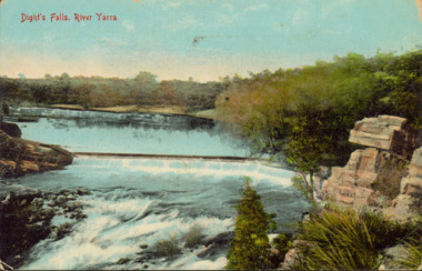
Postcard - Dight's Falls, River Yarra, c.1911
Dight’s Falls in Studley Park is an artificial weir built on a natural rock bar across the Yarra. The weir was built in the 1840s to provide water to the ‘Ceres’ flour-mill, one of the first in Victoria. The falls were later to become known as Dight’s Falls after the owners of the mill. Later, a pumping station was built on the Kew side of the river, which pumped water uphill to a reservoir in Walmer Street that provided water to the Melbourne Botanical Gardens and to Albert Park Lake. The area around Dight’s Falls was and is frequently used for recreational activities.Dated postcard allowing one to analyse the form of the Falls in 1911Colour postcard, of Dight's Falls on the River Yarra between Kew and Fairfield. The photograph is taken looking upstream towards the Falls from the Kew side, from the embankment in the vicinity of the Pumping Station. Obverse: "Dight's falls, Kew" Reverse: "Printed in Great Britain Writing in ink on Reverse: "31/3/1911 / To dear Nell with best wishes for a happy birthday from your old friend Eve / [Addressed to] "Mrs N Dunn, Prahran" Franked Victorian 1d stamp on Reverse top rightdight's falls, dight's falls - kew (vic) - fairfield (vic) -
 Kew Historical Society Inc
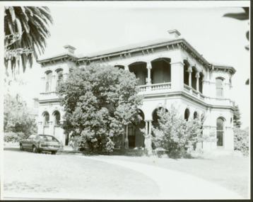
Photograph - 'Mandalay', 3 Molesworth Street (Kew), 1979
'Mandalay' at 3 Molesworth Street, Kew was originally named 'Kaikoura'. Pru Sanderson's 'Kew Urban Conservation Study' (1988) describes the house as: "The first documentary evidence of this property records that William Dawson was the original owner and occupier of this substantial two-storey mansion, built at the outset of the economic depression of the 1890s. Having an initial N.A.V. of £120 4, the house was occupied by Dawson until at least 1904. This two-storeyed rendered house is Italianate in styling and is dominated by a two-storeyed loggia that spans two facades. At ground floor level it is supported on coupled cast iron colonettes and above has single colonettes that support stilted segmental arches. The house is quite typical of its time, however it bears a strong resemblance to 39 Sackville Street probably by Beswicke and Coote (q.v.), and 'Kawarau'.in Hawthorn, designed by Coote. The similarity of these buildings and the fact that Beswicke and Coote called tenders for a house in Molesworth Street, both suggest that this house was also by that firm.Large original, black and white print positive photograph of 3 Molesworth Street, Kew The two storey Italianate mansion has a double loggia and two bay windows on the side of the property. A car is parked in front.manadaly - molesworth street (kew), historic houses -- kew, italianate architecture -- kew (vic.), kaikoura -- molesworth street -- kew (vic.), beswicke & coote -
 Kew Historical Society Inc
Journal, Kewriosity : August 1991
The greening of Kew [Street Tree Masterplan] / p1. Free mulching of prunings / p1. Looming threat to the character of Kew [Victorian Government plans for medium-density housing] / p1. Diary dates for August / p2. Free self-defence and relaxation classes / p2. Anonymous house [house numbering requirements] / p2. Tom's incredible Spider Ring! ['The Spider Ring' by Track Players] / p2. Commentary / Cr Daryl Oldaker p3. Chief Executive's Column [Property valuations] / p3. Looking down rat holes [storm water drain audit] / p4. Waste plans not half baked [120 Litre Mobile Bin Recycling Trial] / p4. Lower your gas and electricity bills [Kew Community House workshops] / p4. Tribute to John Fleet Maughan 1898-1991 [City Engineer 1924-63] / p4. Indoor celebration of parkland [opening of Burke Road to High Street section of Outer Circle Linear Park] / p5. Forward planning for youth [survey] / p5. Kew saves an endangered species [Studley Park Red Gum - E.Studleyensis] / p5. Compliments, criticism and complaints [Kew Library Comments Book] / p6. Life in East Kew / Mr Tony de Clifford p6. New face [Pierrette Boustany, Outside School Hours Co-ordinator] / p6. New face [Lisa Gaffney, Public Relations Officer] / p6. Kewriosity deadlines / p6. Advertising [charges] / p6. Thankyou to the volunteers of Kew / p7. Another Anniversaire [Count Francoise de la Perouse] / p7. Heartfelt thanks [donation by East Kew Synagogue congregation to Kew Citizens' Advice Bureau] / p7. Kew Rotary Club good works / p7. Cinema to expand [Balwyn Cinema] / p7. Winter Song [Brian Hansford performs 'Winterreise at St John's Hall, Camberwell] / p8. Come to Cameron Country [Donald Cameron et al at Kew Gallery] / p8. You be the Gypsy [Victor Herbert's 'Gipsy Lady' by Viola Musical Comedy Society] / p8. Classical music in Kew [Kew Philharmonic Society] / p8.Kewriosity was a local newsletter combining Kew Council and community news. It was published between November 1983 and June 1994, replacing an earlier Kewriosity [broad] Sheet (1979-84). In producing Kewriosity, Council aimed to provide a range of interesting and informative articles covering its deliberations and decision making, together with items of general interest and importance to the Kew community and information not generally available through daily media outlets.non-fictionThe greening of Kew [Street Tree Masterplan] / p1. Free mulching of prunings / p1. Looming threat to the character of Kew [Victorian Government plans for medium-density housing] / p1. Diary dates for August / p2. Free self-defence and relaxation classes / p2. Anonymous house [house numbering requirements] / p2. Tom's incredible Spider Ring! ['The Spider Ring' by Track Players] / p2. Commentary / Cr Daryl Oldaker p3. Chief Executive's Column [Property valuations] / p3. Looking down rat holes [storm water drain audit] / p4. Waste plans not half baked [120 Litre Mobile Bin Recycling Trial] / p4. Lower your gas and electricity bills [Kew Community House workshops] / p4. Tribute to John Fleet Maughan 1898-1991 [City Engineer 1924-63] / p4. Indoor celebration of parkland [opening of Burke Road to High Street section of Outer Circle Linear Park] / p5. Forward planning for youth [survey] / p5. Kew saves an endangered species [Studley Park Red Gum - E.Studleyensis] / p5. Compliments, criticism and complaints [Kew Library Comments Book] / p6. Life in East Kew / Mr Tony de Clifford p6. New face [Pierrette Boustany, Outside School Hours Co-ordinator] / p6. New face [Lisa Gaffney, Public Relations Officer] / p6. Kewriosity deadlines / p6. Advertising [charges] / p6. Thankyou to the volunteers of Kew / p7. Another Anniversaire [Count Francoise de la Perouse] / p7. Heartfelt thanks [donation by East Kew Synagogue congregation to Kew Citizens' Advice Bureau] / p7. Kew Rotary Club good works / p7. Cinema to expand [Balwyn Cinema] / p7. Winter Song [Brian Hansford performs 'Winterreise at St John's Hall, Camberwell] / p8. Come to Cameron Country [Donald Cameron et al at Kew Gallery] / p8. You be the Gypsy [Victor Herbert's 'Gipsy Lady' by Viola Musical Comedy Society] / p8. Classical music in Kew [Kew Philharmonic Society] / p8. publications -- city of kew (vic.), kewriosity, council newsletters, community newsletters -
Kew Historical Society Inc
Journal, Kewriosity : April 1990
Rates reminder / p1. The greening of Kew / p1. Dates for April / p2. Dog fees due / p2. Streetscaping plan / p3. Commentary / Cr Michael Montalto / p3 Residential policies review / p3 . Community bus / p3. High Street parking changes / p3. [Easter] Holiday Program / p4. Library corner / p4. Notices [Anniversary fete] / p4. The view from the dome [Sacred Heart Church] / p4. Car control course for young drivers / p4. Singles talk / p4. Anzac Day / p5. Office [development] Policy launched / p5. Federal Minister in firing line [Family Day Care programs] / p5. Possums playgroup / p5. World focus on literacy this year / p6. Credit card debt a nightmare / p6. Garden weddings fee [Alexandra Gardens] / p6. Siena [College] is 50 / p6. Painting for Kew Library [Studley Park Conservation Society, Louise Folleta - 'Yarra River at Studley Park'] / p7. One year on for women's club [Kew Ladies Probus Club] / p7. In Brief / p7. Council strengthens YMCA links [Kew Recreation Centre] / p7. Neighbourhood Watch / p8. Traffic Management update / p8. Consumer matters / p8. Back care seminar / p8. Introducing the "Fact Pack" [Youth Services] / p8.Kewriosity was a local newsletter combining Kew Council and community news. It was published between November 1983 and June 1994, replacing an earlier Kewriosity [broad] Sheet (1979-84). In producing Kewriosity, Council aimed to provide a range of interesting and informative articles covering its deliberations and decision making, together with items of general interest and importance to the Kew community and information not generally available through daily media outlets.non-fictionRates reminder / p1. The greening of Kew / p1. Dates for April / p2. Dog fees due / p2. Streetscaping plan / p3. Commentary / Cr Michael Montalto / p3 Residential policies review / p3 . Community bus / p3. High Street parking changes / p3. [Easter] Holiday Program / p4. Library corner / p4. Notices [Anniversary fete] / p4. The view from the dome [Sacred Heart Church] / p4. Car control course for young drivers / p4. Singles talk / p4. Anzac Day / p5. Office [development] Policy launched / p5. Federal Minister in firing line [Family Day Care programs] / p5. Possums playgroup / p5. World focus on literacy this year / p6. Credit card debt a nightmare / p6. Garden weddings fee [Alexandra Gardens] / p6. Siena [College] is 50 / p6. Painting for Kew Library [Studley Park Conservation Society, Louise Folleta - 'Yarra River at Studley Park'] / p7. One year on for women's club [Kew Ladies Probus Club] / p7. In Brief / p7. Council strengthens YMCA links [Kew Recreation Centre] / p7. Neighbourhood Watch / p8. Traffic Management update / p8. Consumer matters / p8. Back care seminar / p8. Introducing the "Fact Pack" [Youth Services] / p8. publications -- city of kew (vic.), kewriosity, council newsletters, community newsletters -
Kew Historical Society Inc
Journal, Kewriosity : November 1985
Our window [Alan Sumner, The Four Seasons] / p1. Linear Park will not affect E6 [Outer Circle railway reserve] / p1&5. Dates for November / p2&8. [Community] Notices / p2. Update: Notes from Council - [Council] Budget Go-ahead / Cr Phyllis Hore [Mayor of Kew] / p3. Traffic management / p3. In Brief [Recycling transfer; Walmer Street Appeal quashed; Deregulation of shared housing; Review sought on full day care decision; Whither Willsmere?; Cable tram centenary exhibition; Election possible; Community Assistance Grants] / p4. Death of Councillor Murray Wood / p4. 40 years of home-help in Kew / p5. Three year old Kinder [Argyle Road; Davis Street] / p5. Youth Page - New publications for youth [Streetwise comics; Making unemployment work] / p6. How we passed our time - 2 [social history] / Bill Stent p7. A Group Apprenticeship Scheme for Eastern Suburbs / p7. Kew Community House / p8. Room for one more [student hosting] / p8. North Kew Tennis Club / p8. Kew Young Liberals / p8. Kew Band in concert / p8.Kewriosity was a local newsletter combining Kew Council and community news. It was published between November 1983 and June 1994, replacing an earlier Kewriosity [broad] Sheet (1979-84). In producing Kewriosity, Council aimed to provide a range of interesting and informative articles covering its deliberations and decision making, together with items of general interest and importance to the Kew community and information not generally available through daily media outlets.non-fictionOur window [Alan Sumner, The Four Seasons] / p1. Linear Park will not affect E6 [Outer Circle railway reserve] / p1&5. Dates for November / p2&8. [Community] Notices / p2. Update: Notes from Council - [Council] Budget Go-ahead / Cr Phyllis Hore [Mayor of Kew] / p3. Traffic management / p3. In Brief [Recycling transfer; Walmer Street Appeal quashed; Deregulation of shared housing; Review sought on full day care decision; Whither Willsmere?; Cable tram centenary exhibition; Election possible; Community Assistance Grants] / p4. Death of Councillor Murray Wood / p4. 40 years of home-help in Kew / p5. Three year old Kinder [Argyle Road; Davis Street] / p5. Youth Page - New publications for youth [Streetwise comics; Making unemployment work] / p6. How we passed our time - 2 [social history] / Bill Stent p7. A Group Apprenticeship Scheme for Eastern Suburbs / p7. Kew Community House / p8. Room for one more [student hosting] / p8. North Kew Tennis Club / p8. Kew Young Liberals / p8. Kew Band in concert / p8. publications -- city of kew (vic.), kewriosity, council newsletters, community newsletters -
Kew Historical Society Inc
Journal, Kewriosity : July 1984
Street trees in Kew [Carol Frank-Mas & Associates, Landscape Architects Report] / p1. Community [Gamblers Annymousl Action Programme; Save the Children Fund; Kew Garden Club; Native Plant Group; Kew Baptist Church; Hyde Park Fellowship; Film afternoon; Toy Library; Kew Junction Traders - advertising] / p2. Raoul Wallenberg Gardens / p3. Kew Recreation Centre / p3. Kew Historical Society / p3. Kew Community House / p4. Youth Pages [New Youth Centre for Kew; Unemployed? / p5. International Youth Year 1985 [What is it? So..., In Kew! Plans] / p6-7. [Youth] Talkback / p7. Things to do in Kew [&] A bit further afield [Kew Drop-in; After school activities; The Gap; Teen Club; Community House] / p8. Mayoral Comment - "Villa Alba" / Cr Jill O'Brien [Mayor of Kew] / p9. Community Directory updates / p9. Sahara Yoga [Centre] / p10. Community artists / p10. Highbury Grove Playgroup / p10. Kew Senior Citizens' Centre / p10. Powerlines and street trees / p11. Kindergarten enrolments / p11. Immunisation sessions / p11. Roadworks / p11. Drivers needed [Kew Community Bus] / p11. Domestic noise / p11. C.A.B. [Citizens' Advice Bureau] / p11. Kew (Daytime) Garden Club / p11. Kew people for nuclear disarmament / p11. H.K.C. Activities Centre / p11. Children's Services in Kew [Occasional Care Centre; Children's Services Officer; Full-Time Day Care Centre; Three Year Old Kindergarten; After School Programme; Extended Hours Kindergarten] / p12.Kewriosity was a local newsletter combining Kew Council and community news. It was published between November 1983 and June 1994, replacing an earlier Kewriosity [broad] Sheet (1979-84). In producing Kewriosity, Council aimed to provide a range of interesting and informative articles covering its deliberations and decision making, together with items of general interest and importance to the Kew community and information not generally available through daily media outlets.non-fictionStreet trees in Kew [Carol Frank-Mas & Associates, Landscape Architects Report] / p1. Community [Gamblers Annymousl Action Programme; Save the Children Fund; Kew Garden Club; Native Plant Group; Kew Baptist Church; Hyde Park Fellowship; Film afternoon; Toy Library; Kew Junction Traders - advertising] / p2. Raoul Wallenberg Gardens / p3. Kew Recreation Centre / p3. Kew Historical Society / p3. Kew Community House / p4. Youth Pages [New Youth Centre for Kew; Unemployed? / p5. International Youth Year 1985 [What is it? So..., In Kew! Plans] / p6-7. [Youth] Talkback / p7. Things to do in Kew [&] A bit further afield [Kew Drop-in; After school activities; The Gap; Teen Club; Community House] / p8. Mayoral Comment - "Villa Alba" / Cr Jill O'Brien [Mayor of Kew] / p9. Community Directory updates / p9. Sahara Yoga [Centre] / p10. Community artists / p10. Highbury Grove Playgroup / p10. Kew Senior Citizens' Centre / p10. Powerlines and street trees / p11. Kindergarten enrolments / p11. Immunisation sessions / p11. Roadworks / p11. Drivers needed [Kew Community Bus] / p11. Domestic noise / p11. C.A.B. [Citizens' Advice Bureau] / p11. Kew (Daytime) Garden Club / p11. Kew people for nuclear disarmament / p11. H.K.C. Activities Centre / p11. Children's Services in Kew [Occasional Care Centre; Children's Services Officer; Full-Time Day Care Centre; Three Year Old Kindergarten; After School Programme; Extended Hours Kindergarten] / p12. publications -- city of kew (vic.), kewriosity, council newsletters, community newsletters -
Kew Historical Society Inc
Journal, The Kewriosity Sheet Vol.1 No.3 : August 1979
What's doing in Kew for August / p1. We want your news! / p1. Kew Municipal Library: Where children are VIP / p1. 25 years of service: Kew Lions Anniversary / p1. Miss Shepheard retires [Stawell Street Kindergarten] / p1. Studley Park Progress Association / p1. Entertainers needed [Kew Entertainment Workshop] / p1. Rotaract ski weekend / p1. Kew Historical Society: Memorials in Kew / p2. Children's Week 1979 / p2. Limerick of the month / p2. Theatre in Education [Kew High School] / p2. Nursing Mothers Association / p2. Mid-week tennis / p2. [Kew] Swimming Club / p2. Help where it's needed [Sacred Heart Kew Caring Group] / p2. Kew City Bowmen / p2. Holiday help [Meals on Wheels] / p2. Child Development Seminar / p2. Council News: For your safety [Roundabouts; If you're un-building [demolitions]; Traffic School; School Holidays] / p2. Citizens' Advice Bureau / p2.The Kewriosity Sheet (1979-83) was first published in the City of Kew (Victoria) in June 1979 as a two-sided 'community newssheet'. It aimed to: 'share news about Kew happenings and Kew people, and to exchange ideas about living in Kew'. Later issues gradually evolved into a 4-page, quarto sized publication. The Kewriosity Sheet was superseded by the Kew Council publication 'Kewriosity' (1983-1994).non-fictionWhat's doing in Kew for August / p1. We want your news! / p1. Kew Municipal Library: Where children are VIP / p1. 25 years of service: Kew Lions Anniversary / p1. Miss Shepheard retires [Stawell Street Kindergarten] / p1. Studley Park Progress Association / p1. Entertainers needed [Kew Entertainment Workshop] / p1. Rotaract ski weekend / p1. Kew Historical Society: Memorials in Kew / p2. Children's Week 1979 / p2. Limerick of the month / p2. Theatre in Education [Kew High School] / p2. Nursing Mothers Association / p2. Mid-week tennis / p2. [Kew] Swimming Club / p2. Help where it's needed [Sacred Heart Kew Caring Group] / p2. Kew City Bowmen / p2. Holiday help [Meals on Wheels] / p2. Child Development Seminar / p2. Council News: For your safety [Roundabouts; If you're un-building [demolitions]; Traffic School; School Holidays] / p2. Citizens' Advice Bureau / p2. community publications --- kew (vic.), the kewriosity sheet, newsletters - kew (vic.) -
Kew Historical Society Inc
Journal, The Kewriosity Sheet Vol.1 No.5 : October 1979
What's doing in Kew for October / p1. Keeping Kew beautiful [Parks and Gardens: Alexandra Gardens - Kew; Kew Garden Club; Willsmere Park; Victoria Park; Eglinton Reserve] / p1. Your news is good news / p1. Got some spare time [Henry Pride] / p1. Young people's club [Fitzwilliam Street People's Church] / p1. Fun and fellowship [Kew Uniting Church Youth Group] / p1. Learn to swim next year! / p1. Bring your orchid [Kew Garden Club] / p2. Retired and looking for something to do? [Kew Elder Citizens] / p2. Your help needed [The Kewriosity Sheet] / p2. [Aphorisms] / p2. Songs my mother sang / p2. Recreation courses / p2. Multiple Sclerosis Unit / p2. You you get ideas? [East Kew Uniting Church] / p2. E.P.R.G. (Early Planning for Retirement Group] / p2. Mum - It's for you! / p2. Action for the handicapped / p2. Biggest rug in the world / p2. Council News [City Hall Bookings; Town Planning; Unburnable rubbish; Family Day Care Scheme; Community Occupational Therapist; Kew Community Directory; Come meet your Mayor (Cr Kaye Cole) / p2. Do it yourself duplicating [Copy Shop] / p2. Meals on - tables [Kew Elderly Citizens' Club] / p2.The Kewriosity Sheet (1979-83) was first published in the City of Kew (Victoria) in June 1979 as a two-sided 'community newssheet'. It aimed to: 'share news about Kew happenings and Kew people, and to exchange ideas about living in Kew'. Later issues gradually evolved into a 4-page, quarto sized publication. The Kewriosity Sheet was superseded by the Kew Council publication 'Kewriosity' (1983-1994).non-fictionWhat's doing in Kew for October / p1. Keeping Kew beautiful [Parks and Gardens: Alexandra Gardens - Kew; Kew Garden Club; Willsmere Park; Victoria Park; Eglinton Reserve] / p1. Your news is good news / p1. Got some spare time [Henry Pride] / p1. Young people's club [Fitzwilliam Street People's Church] / p1. Fun and fellowship [Kew Uniting Church Youth Group] / p1. Learn to swim next year! / p1. Bring your orchid [Kew Garden Club] / p2. Retired and looking for something to do? [Kew Elder Citizens] / p2. Your help needed [The Kewriosity Sheet] / p2. [Aphorisms] / p2. Songs my mother sang / p2. Recreation courses / p2. Multiple Sclerosis Unit / p2. You you get ideas? [East Kew Uniting Church] / p2. E.P.R.G. (Early Planning for Retirement Group] / p2. Mum - It's for you! / p2. Action for the handicapped / p2. Biggest rug in the world / p2. Council News [City Hall Bookings; Town Planning; Unburnable rubbish; Family Day Care Scheme; Community Occupational Therapist; Kew Community Directory; Come meet your Mayor (Cr Kaye Cole) / p2. Do it yourself duplicating [Copy Shop] / p2. Meals on - tables [Kew Elderly Citizens' Club] / p2. community publications --- kew (vic.), the kewriosity sheet, newsletters - kew (vic.) -
Kew Historical Society Inc
Journal, The Kewriosity Sheet Vol.1 No.7 : December 1979
What's doing in Kew for December / p1. Kew Elder Citizens [Members; The building; Activities; The Choir; Over 80s; Opportunity Shop; Outings; Supervisor; "For Friends of the Aged"] / Gwlad Wade p1. Your news s good news / p1. Village without a name [Edgevale Road] / Barbara Giles p2. Kew Joggers Group / p2. Kinder contributes to the International Year of the Child [Davis Street Kindergarten] / p2. Christmas Church Services / p2. Australian Kite Association / Helen Bushell p2. A.R.A.F.E.M.I. - A new association for Victoria [Association of Relatives and Friends of the Emotionally and Mentally Ill] / p2. Other meetings of local interest / p2. Council News [Roadworks for the year; Municipal Offices - Access for the disabled; Parks and recreations areas; Human Services; Christmas Holiday Programme] / p2. Kew Croquet Club / p2.The Kewriosity Sheet (1979-83) was first published in the City of Kew (Victoria) in June 1979 as a two-sided 'community newssheet'. It aimed to: 'share news about Kew happenings and Kew people, and to exchange ideas about living in Kew'. Later issues gradually evolved into a 4-page, quarto sized publication. The Kewriosity Sheet was superseded by the Kew Council publication 'Kewriosity' (1983-1994).non-fictionWhat's doing in Kew for December / p1. Kew Elder Citizens [Members; The building; Activities; The Choir; Over 80s; Opportunity Shop; Outings; Supervisor; "For Friends of the Aged"] / Gwlad Wade p1. Your news s good news / p1. Village without a name [Edgevale Road] / Barbara Giles p2. Kew Joggers Group / p2. Kinder contributes to the International Year of the Child [Davis Street Kindergarten] / p2. Christmas Church Services / p2. Australian Kite Association / Helen Bushell p2. A.R.A.F.E.M.I. - A new association for Victoria [Association of Relatives and Friends of the Emotionally and Mentally Ill] / p2. Other meetings of local interest / p2. Council News [Roadworks for the year; Municipal Offices - Access for the disabled; Parks and recreations areas; Human Services; Christmas Holiday Programme] / p2. Kew Croquet Club / p2. community publications --- kew (vic.), the kewriosity sheet, newsletters - kew (vic.) -
 Kew Historical Society Inc
Photograph - Second Johnston Street Bridge in Flood, 1934
Original, small black and white print photograph of crowds lining the Johnston Street Bridge watching the flood waters below. The annotation on the reverse clarifies that Kew is in the distance.Annotated on reverse: "Gift of G.S. Beard / 2nd bridge / Johnston St. Studly Park Rd. Bridge looking towards Kew / 1st bridge 1858–1876, 2nd bridge built (bad bend), 1876–1958, 3rd bridge 1958, lined up Johnston St and Studley Park Rd."johnston street bridge, bridges - yarra river -- kew (vic.), flood -- 1934 -
 Kew Historical Society Inc
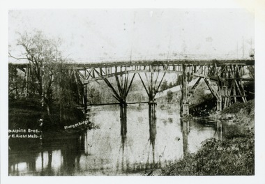
Print, Studley Pk Toll Bridge, July 12 1899
Black and white print photograph of the wooden 'Penny Bridge' at Studley Park. The name was colloquially arrived at as a penny wa the toll one paid to cross the bridge. The copy of the postcard identifies the photographers as McAlpin Bros, Richmond.Reverse: "Studley Pk Toll Bridge / joining Church Street Abbotsford / Penny Bridge"toll bridges -- river yarra, bridges - yarra river -- kew (vic.), penny bridge -
 Kew Historical Society Inc
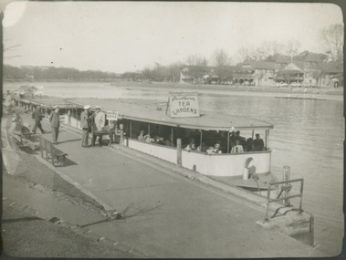
Photograph - Hicks' Cruiser berthed on the Yarra at Princess Bridge, c.1953
Commercially-operated boat tours on the Maribyrnong and Yarra Rivers in Melbourne were a major tourist attraction, especially in the first half of the twentieth century. A number of companies ran ferries and motor-launches to locations such as the Riverview Tea Gardens (1909-1947) at Ascot Vale, and the Hawthorn Tea Gardens on the corner of Power Street and Riversdale Road. One of the families which ran these services was Hicks Bros, which from circa 1921 operated a ferry service from Princess Walk (Melbourne) to Studley Park. This is one of a series of 17 black and white undated photographic proofs donated to the Kew Historical Society in 2013 by the Queenscliffe Historical Museum. The series includes images of individuals, tea rooms, ferries, motor launches, ocean liners and tugs. In 1953, the owner of Hicks Bros was involved in an inquest into the drowning of a Ukrainian tourist on a ferry operated by Melbourne Ferries, a rival firm. In published reports of the inquest, reference is made to a number of photographs taken by Robert Irvine Atchison, part-owner of Hicks Bros. As the reverse of the photographs indicates copyright is held by the State of Victoria, the collection may have derived from that year.Black and white print of a tourist cruiser berthed on the River Yarra at Princess Bridge. The sign on the cruiser says 'Tea Gardens' so its destination may have been the Hawthorn Tea Gardens. The single story, wide barge like roofed ferry has passengers on board. The ticket seller can be seen beside the boat on the moorings. tourism -- melbourne (vic.), ferries, yarra river, hick's cruises, hawthorn tea gardens -
 Kew Historical Society Inc
Photograph - Hicks' Cruises ticket seller at Princess Bridge, c.1953
Commercially-operated boat tours on the Maribyrnong and Yarra Rivers in Melbourne were a major tourist attraction, especially in the first half of the twentieth century. A number of companies ran ferries and motor-launches to locations such as the Riverview Tea Gardens (1909-1947) at Ascot Vale, and the Hawthorn Tea Gardens on the corner of Power Street and Riversdale Road. One of the families which ran these services was Hicks Bros, which from circa 1921 operated a ferry service from Princess Walk (Melbourne) to Studley Park. This is one of a series of 17 black and white undated photographic proofs donated to the Kew Historical Society in 2013 by the Queenscliffe Historical Museum. The series includes images of individuals, tea rooms, ferries, motor launches, ocean liners and tugs. In 1953, the owner of Hicks Bros was involved in an inquest into the drowning of a Ukrainian tourist on a ferry operated by Melbourne Ferries, a rival firm. In published reports of the inquest, reference is made to a number of photographs taken by Robert Irvine Atchison, part-owner of Hicks Bros. As the reverse of the photographs indicates copyright is held by the State of Victoria, the collection may have derived from that year.Closeup photograph of a ticket seller touting for business for a tourist ferry moored at Princess Bridge The sign on the boat identifies the destination of the ferry as 'Studley Park via Hawthorn Tea Gardens'. The ferry is empty of passengers.hicks' cruises, tourism -- melbourne (vic.), river yarra, studley park, hawthorn tea gardens -
 Kew Historical Society Inc
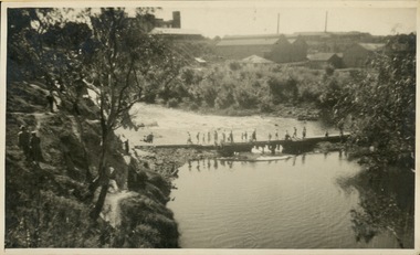
Photograph - Crossing Dights' Falls on the Yarra by foot
Dight’s Falls in Studley Park is an artificial weir built on a natural rock bar across the Yarra. The weir was built in the 1840s to provide water to the ‘Ceres’ flour-mill, one of the first in Victoria. The falls were later to become known as Dight’s Falls after the owners of the mill. Later, a pumping station was built on the Kew side of the river, which pumped water uphill to a reservoir in Walmer Street that provided water to the Melbourne Botanical Gardens and to Albert Park Lake. The area around Dight’s Falls was and is frequently used for recreational activities.Rare original print photograph of people walking across Dight's Falls when the river flow was low. View west towards Abbotsford. Photograph taken from Kew side of river above the Falls.Reverse: "M Holmes"dight's falls, river yarra -- kew - abbotsford -
 Kew Historical Society Inc
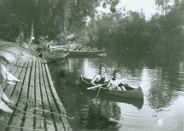
Photograph - Canoeing at Macauley's Boathouse, 1950s
Macauley's boat sheds (aka Kew Boatsheds) was located on the river at the western end of Molesworth Street, Kew.Black and white enlargement. Two children pictured in a canoe at Macauley's Boathouse on the River Yarra at Studley Park.Reverse: "Macauley's Boatsheds / M Holmes"boathouses -- river yarra, boathouses -- kew, macauley's boat shed, recreation -- canoeing -
Kew Historical Society Inc
Journal, The Kewriosity Sheet Vol.2 No.9 : March 1981
[Kew] Festival issue [programme] / p1&2. Typical craft work of the colonial period [Stefan Nechwatal] / p1. Festival photo competition / p2. What's doing in Kew for March / p2&3. The Alexandra Gardens / Elizabeth Mackie p3. Hyde Park Fellowship / p3. English classes for migrant women [Denmark Street Baby Health Centre] / p4. Citizens' Advice Bureau [International Year of the Disabled Person] / p4. Full participation and equality / [Disability; Rheumatism & Arthritis Association of Victoria] / M.J. Meyers p4.The Kewriosity Sheet (1979-83) was first published in the City of Kew (Victoria) in June 1979 as a two-sided 'community newssheet'. It aimed to: 'share news about Kew happenings and Kew people, and to exchange ideas about living in Kew'. Later issues gradually evolved into a 4-page, quarto sized publication. The Kewriosity Sheet was superseded by the Kew Council publication 'Kewriosity' (1983-1994).non-fiction[Kew] Festival issue [programme] / p1&2. Typical craft work of the colonial period [Stefan Nechwatal] / p1. Festival photo competition / p2. What's doing in Kew for March / p2&3. The Alexandra Gardens / Elizabeth Mackie p3. Hyde Park Fellowship / p3. English classes for migrant women [Denmark Street Baby Health Centre] / p4. Citizens' Advice Bureau [International Year of the Disabled Person] / p4. Full participation and equality / [Disability; Rheumatism & Arthritis Association of Victoria] / M.J. Meyers p4. community publications --- kew (vic.), the kewriosity sheet, newsletters - kew (vic.) -
Kew Historical Society Inc
Journal, The Kewriosity Sheet Vol.2 No.12 : June 1981
Choral Festival Service 1981 [Kew Inter-Church and Church Affiliated Schools Choral Festival Service; Holy Trinity Church] / p1. Save the Children Fund / p1. Do you live in Kew or nearby? [Volunteers; Meals on Wheels] / p1. Kew Crossroads Club [A Christian Fellowship for Handicapped Teenagers] / p1. Volunteer Reader / p1. The Mouse House [104 Peel Street] / Elizabeth Mackie p2. What's doing in Kew for June / p2&3. Kew C.A.A. Winter wine bottling [Kew Community Aid Abroad] / p3. Multicultural Church [East Kew Baptist Church] / p3. Kew Philharmonic Society / p3. Council News - I.Y.D.P: Can you help [International Year of Disabled Persons]; Victoria Welcome Group [Volunteers; Migration]; Message from the Minister [Jeff Kennett; Immigration and Ethnic Affairs] / p4. Kew Garden Club / p4. Hyde Park F'ship [Hyde Park Church] / p4. New members needed for [Kew Royal Women's Hospital Auxiliary] / p4. Copy Shop / p4.The Kewriosity Sheet (1979-83) was first published in the City of Kew (Victoria) in June 1979 as a two-sided 'community newssheet'. It aimed to: 'share news about Kew happenings and Kew people, and to exchange ideas about living in Kew'. Later issues gradually evolved into a 4-page, quarto sized publication. The Kewriosity Sheet was superseded by the Kew Council publication 'Kewriosity' (1983-1994).non-fictionChoral Festival Service 1981 [Kew Inter-Church and Church Affiliated Schools Choral Festival Service; Holy Trinity Church] / p1. Save the Children Fund / p1. Do you live in Kew or nearby? [Volunteers; Meals on Wheels] / p1. Kew Crossroads Club [A Christian Fellowship for Handicapped Teenagers] / p1. Volunteer Reader / p1. The Mouse House [104 Peel Street] / Elizabeth Mackie p2. What's doing in Kew for June / p2&3. Kew C.A.A. Winter wine bottling [Kew Community Aid Abroad] / p3. Multicultural Church [East Kew Baptist Church] / p3. Kew Philharmonic Society / p3. Council News - I.Y.D.P: Can you help [International Year of Disabled Persons]; Victoria Welcome Group [Volunteers; Migration]; Message from the Minister [Jeff Kennett; Immigration and Ethnic Affairs] / p4. Kew Garden Club / p4. Hyde Park F'ship [Hyde Park Church] / p4. New members needed for [Kew Royal Women's Hospital Auxiliary] / p4. Copy Shop / p4. community publications --- kew (vic.), the kewriosity sheet, newsletters - kew (vic.) -
Kew Historical Society Inc
Journal, The Kewriosity Sheet Vol.3 No.3 : September 1981
Home tutors for migrants [Jill Manton] / p1. Harp, Browse and Buy [Harp Browse and Buy Shop; Victoria Schizophrenia Fellowship] / p1. East Kew Uniting Church / p1. Spring-time Fair [East Kew Uniting Church] /p2. Do you know? [Parents of Disabled Persons] / p2. What's doing in Kew for September / p2&3 Women's Recreation Program /p3. Guest to preach at Kew Baptist Church [Rev. Brian Willersdorf] / p3. Minibus drivers and jockeys [Meals on Wheels] / p3. Hyde Park Fellowship [Hyde Park Church] / p3. Mission Spring Fair [Missionary Sisters of St Peter Claver / p3. The gateway to Kew [Charles Grimes Expedition; Johnston Street Bridge; Studley Park Road; Raheen; Campion Hall; Burke Hall; Studley House; Villa Alba] / Elizabeth Mackie p4. Council News - Family and Community Services (FACS) Programme; Community Service Grants; Deafness Awareness Week; ] / p4.The Kewriosity Sheet (1979-83) was first published in the City of Kew (Victoria) in June 1979 as a two-sided 'community newssheet'. It aimed to: 'share news about Kew happenings and Kew people, and to exchange ideas about living in Kew'. Later issues gradually evolved into a 4-page, quarto sized publication. The Kewriosity Sheet was superseded by the Kew Council publication 'Kewriosity' (1983-1994).non-fictionHome tutors for migrants [Jill Manton] / p1. Harp, Browse and Buy [Harp Browse and Buy Shop; Victoria Schizophrenia Fellowship] / p1. East Kew Uniting Church / p1. Spring-time Fair [East Kew Uniting Church] /p2. Do you know? [Parents of Disabled Persons] / p2. What's doing in Kew for September / p2&3 Women's Recreation Program /p3. Guest to preach at Kew Baptist Church [Rev. Brian Willersdorf] / p3. Minibus drivers and jockeys [Meals on Wheels] / p3. Hyde Park Fellowship [Hyde Park Church] / p3. Mission Spring Fair [Missionary Sisters of St Peter Claver / p3. The gateway to Kew [Charles Grimes Expedition; Johnston Street Bridge; Studley Park Road; Raheen; Campion Hall; Burke Hall; Studley House; Villa Alba] / Elizabeth Mackie p4. Council News - Family and Community Services (FACS) Programme; Community Service Grants; Deafness Awareness Week; ] / p4. community publications --- kew (vic.), the kewriosity sheet, newsletters - kew (vic.) -
Kew Historical Society Inc
Journal, The Kewriosity Sheet Vol.4 No.1 : August 1982
Community effort for St Paul's [School for the Blind] / p1. Annual elections for the City of Kew - North Ward [J. Ormando, P.R. Palmer]; College Ward [P.M. Tunney, P.N.V. Wallinga]; Studley Park Ward [R.E.H. Saunders, M.J. Slattery] / p1. Scrabble / p1. School Holiday Program / p1. R.A.A.V. [Rheumatism and Arthritis Association of Victoria] / p1. Early Planning for Retirement Group / p1. Calling all pioneers!!! [Kew Historical Society; Allen family] / p1. Hyde Park Fellowship [Hyde Park Uniting Church] / p2. What's doing in Kew for August / p2&3. Starlight Theatre Company presents "Gi Gi" / p3. Kew's library grows [Large print books] / p3. Remember boneseed blitz [Studley Park] / p3. "Drop in" [Kew Uniting Church] / p3. Kew Garden Club / p3. Kew Elder Citizen's Club / p3. In the Streets of Kew [transport history] / Barbara Giles p4. Play Centre [Toddler/Kindy Gym Play Centre] / p4. Native Plant Group / p4.The Kewriosity Sheet (1979-83) was first published in the City of Kew (Victoria) in June 1979 as a two-sided 'community newssheet'. It aimed to: 'share news about Kew happenings and Kew people, and to exchange ideas about living in Kew'. Later issues gradually evolved into a 4-page, quarto sized publication. The Kewriosity Sheet was superseded by the Kew Council publication 'Kewriosity' (1983-1994).non-fictionCommunity effort for St Paul's [School for the Blind] / p1. Annual elections for the City of Kew - North Ward [J. Ormando, P.R. Palmer]; College Ward [P.M. Tunney, P.N.V. Wallinga]; Studley Park Ward [R.E.H. Saunders, M.J. Slattery] / p1. Scrabble / p1. School Holiday Program / p1. R.A.A.V. [Rheumatism and Arthritis Association of Victoria] / p1. Early Planning for Retirement Group / p1. Calling all pioneers!!! [Kew Historical Society; Allen family] / p1. Hyde Park Fellowship [Hyde Park Uniting Church] / p2. What's doing in Kew for August / p2&3. Starlight Theatre Company presents "Gi Gi" / p3. Kew's library grows [Large print books] / p3. Remember boneseed blitz [Studley Park] / p3. "Drop in" [Kew Uniting Church] / p3. Kew Garden Club / p3. Kew Elder Citizen's Club / p3. In the Streets of Kew [transport history] / Barbara Giles p4. Play Centre [Toddler/Kindy Gym Play Centre] / p4. Native Plant Group / p4. community publications --- kew (vic.), the kewriosity sheet, newsletters - kew (vic.) -
Kew Historical Society Inc
Journal, The Kewriosity Sheet Vol.4 No.3 : October 1982
St Paul's School for the Blind and Visually Handicapped / p1. Volunteer drivers needed [Kew Community Bus] / p1. East Central Weights and Measures Union / p1. Uniting Church East Kew - Dairy [sic] for October / p2. Save the Children Fund / p2. Kew Skin Diving Club / p2. Kew Library [Deafness Awareness Week] / p2. St Paul's luncheon and fashion parade / p2. Scouts 50th anniversary dinner [6th Kew Scouts] / p3. Kew Garden Club / p3. R.A.A.V. [Rheumatism and Arthritis Association of Victoria] / p3. Patchwork quilts [Exhibition; Australian Quilters Association] / p3. Cabaret [Kew Baptist Church Young People's Cabaret] / p3. Hyde Park Fellowship [Hyde Park Uniting Church] / p3. Annual Fete [St Paul's East Kew] / p3. They built well: State School No. 1075, Peel Street, Kew [school history] / p4. Native Plant Group / p4.The Kewriosity Sheet (1979-83) was first published in the City of Kew (Victoria) in June 1979 as a two-sided 'community newssheet'. It aimed to: 'share news about Kew happenings and Kew people, and to exchange ideas about living in Kew'. Later issues gradually evolved into a 4-page, quarto sized publication. The Kewriosity Sheet was superseded by the Kew Council publication 'Kewriosity' (1983-1994).non-fictionSt Paul's School for the Blind and Visually Handicapped / p1. Volunteer drivers needed [Kew Community Bus] / p1. East Central Weights and Measures Union / p1. Uniting Church East Kew - Dairy [sic] for October / p2. Save the Children Fund / p2. Kew Skin Diving Club / p2. Kew Library [Deafness Awareness Week] / p2. St Paul's luncheon and fashion parade / p2. Scouts 50th anniversary dinner [6th Kew Scouts] / p3. Kew Garden Club / p3. R.A.A.V. [Rheumatism and Arthritis Association of Victoria] / p3. Patchwork quilts [Exhibition; Australian Quilters Association] / p3. Cabaret [Kew Baptist Church Young People's Cabaret] / p3. Hyde Park Fellowship [Hyde Park Uniting Church] / p3. Annual Fete [St Paul's East Kew] / p3. They built well: State School No. 1075, Peel Street, Kew [school history] / p4. Native Plant Group / p4.community publications --- kew (vic.), the kewriosity sheet, newsletters - kew (vic.) -
Kew Historical Society Inc
Journal, The Kewriosity Sheet Vol.4 No.10 : June 1983
Kew Recreation Program [courses] / p1. Letter to the editor (Nursing homes) / William Martin p1. Kew Kite Club / p1. Kew (Daytime) Garden Club / p2. Kew Library (printing equipment) p2. East Kew Uniting Church (calendar of events) / p2. Kew Historical Society / p2. Save the Children Fund / p2. Scared Heart Kew Caring Group / p2. Why call it that? (street names) / Barbara Giles p3. Melbourne College of Advanced Education (courses & lectures) / p3. Hyde Park Fellowship (Hyde Park Uniting Church) / p4. Solo Club - East Kew / p4. Scrabble / p4. Save the Children Fund / p4. Interested in native plants (Kew Native Plant Group) / p4. The Rheumatism and Arthritis Foundation of Victoria {R.A.A.V.) p4. Rotaract Club of Kew / p4. Kew Toy Library / p4.The Kewriosity Sheet (1979-83) was first published in the City of Kew (Victoria) in June 1979 as a two-sided 'community newssheet'. It aimed to: 'share news about Kew happenings and Kew people, and to exchange ideas about living in Kew'. Later issues gradually evolved into a 4-page, quarto sized publication. The Kewriosity Sheet was superseded by the Kew Council publication 'Kewriosity' (1983-1994).non-fictionKew Recreation Program [courses] / p1. Letter to the editor (Nursing homes) / William Martin p1. Kew Kite Club / p1. Kew (Daytime) Garden Club / p2. Kew Library (printing equipment) p2. East Kew Uniting Church (calendar of events) / p2. Kew Historical Society / p2. Save the Children Fund / p2. Scared Heart Kew Caring Group / p2. Why call it that? (street names) / Barbara Giles p3. Melbourne College of Advanced Education (courses & lectures) / p3. Hyde Park Fellowship (Hyde Park Uniting Church) / p4. Solo Club - East Kew / p4. Scrabble / p4. Save the Children Fund / p4. Interested in native plants (Kew Native Plant Group) / p4. The Rheumatism and Arthritis Foundation of Victoria {R.A.A.V.) p4. Rotaract Club of Kew / p4. Kew Toy Library / p4. community publications --- kew (vic.), the kewriosity sheet, newsletters - kew (vic.)