Showing 296 items matching "park west road"
-
 City of Moorabbin Historical Society (Operating the Box Cottage Museum)
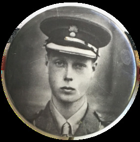
Badge - Visit of the Prince of Wales in 1920, 1954
At the Imperial War Conference in 1917, and again at the conference of overseas Prime Ministers in 1918, King George V had foreshadowed a visit to the Dominions by his eldest son, “when peace comes”. At the end of the War, the King kept his pledge and, following on from successful visits to other countries, including the USA and West Indies in 1919, Edward Albert Christian George Andrew Patrick David, the Prince of Wales, embarked on a journey to Australia. The visit was in part to offer official thanks for the support Australia had shown Great Britain during World War I. It was also designed to strengthen the links between Australia and the Empire. The Prince of Wales arrived in Australia on board the HMS Renown in April 1920, having left England the previous month. He spent nine days in Victoria, eleven days in New South Wales, four days in Tasmania, eleven days in Western Australia, six days in South Australia and eight days in Queensland. In all, he visited 110 cities and towns across Australia.Metal badge with photo of Prince of Walesprince of wales, royal visit 1920, badge -
 Port Melbourne Historical & Preservation Society
Photograph - Port Melbourne, Pat Grainger, 2003
.01 Princes Street facade of Excelsior Hall, prior to renovation 2003 .02 Arnott's biscuit truck converted into camper van, seen parked in Station Street, 2003 .03 Railway Reserve from Station Street, 2003 .04 Notice for Trash & Treasure, Todd Road offramp, 2003parks and gardens, excelsior hall, west gate bridge, arnott's biscuits ltd, station street, todd road, railway reserve, swallow & ariell ltd -
 Coal Creek Community Park & Museum
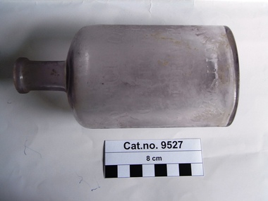
Bottle, glass, c. 1885
150 years of experience and commitment. Norwegians have been producing and exporting cod liver oil for more than 1000 years. But it was not before 1645 it was reported that cod liver oil could be used to prevent and cure disease. At the end of the 18th century the first scientific article was published to support this. In the middle of the 19th century, the pharmacist Peter Möller observed that people along the west coast of Norway consuming cod liver oil regularly were rarely ill. He dedicated himself to finding out how this healthy liquid could be produced with better taste and pureness at a lower price. He developed a method of using steam to extract the oil from fresh cod livers. Based on this technological advance, the company Peter Möller was founded in 1854 in Lofoten on Norway’s arctic coast, where you find pure, cold, clean seas and high quality raw material. Peter Joachim Möller (1793-1869) At first Möller’s Cod Liver Oil was believed to be a good source of vitamin D and A, and the health benefits were associated with these vitamins. Peter Möller believed, however, that there were other significant benefits from fatty acids and other ingredients in the cod liver oil – both known and unknown. Peter Möller was dedicated to understanding more about these benefits. His dedication and commitment is clear in Möller's vision to improve people’s health by delivering the highest quality omega 3 products. Timeline 1793 Peter Möller is born in Røros, Norway 26 April. 1819 Peter Möller travels to Christiania (Oslo) and is employed by the pharmacist Frantz Peckel at the Svane chemist. He is employed on condition that he passes his pharmaceutical exam within one year. 1822 Graduated as a pharmacist with a unanimous first grade and with the award of the Professor's special satisfaction. 1842 Together with professors A. Holst and Chr. Boeck, Peter Möller participates in the commission which develops the first Norwegian Pharmacopoeia. 1853 Peter announces his method to cod liver oil works along the coast. He equips cod liver oil factories with new equipment in Lofoten, Ålesund and Kristiansund. The facility outside Ålesund is the most important for testing the method. 1854 The Peter Möller company is established as production has started at the three factories. Sales are lower than anticipated even though the quality is considerably better with the new method. The consumers of cod liver oil had been used to the fact that “good medicine must taste bad” and would not believe that the new and better quality was as healthy. Therefore, the following years are used to introduce consumers to the product, and also to convert more producers to the new method. 1869 Peter Möller dies. There are 70 cod liver oil steamers which use his steam rendering method, and 5000 barrels are produced every year. Möller’s company increases the quality by better routines for quality controls. 1870 Severin A Heyerdal, Möller’s son-in-law, assumes the leadership of the firm after Peter's death. He continues the work by improving the quality of the cod liver oil. The goal was to make it as pure and unaltered as in the liver. At this time, Möller had already started selling its product in the USA. In 1870, WH Schieffelin & Co. ("The oldest drughouse in America") was engaged by Peter Möller in the USA. 1881 Frantz Peckel Möller assumes the leadership of the Peter Möller company. He saw it as his duty to further the work on cod liver oil, and through a combination of solid scientific education and an eminent sense of the great mercantile possibilities, he made Möller’s cod liver oil the number one in the world market. 1914 The first world war leads to Möller’s bottled cod liver oil being shut out of the export market. However, domestic sales are good. 1924 The subsidiary Møystad Möller & Co. is established for bulk exports and the Association of Medicinal Cod liver oil Exporters is established in Bergen in 1925. 1925/26 The green bottles are introduced. Medicinal cod liver oil exports remain almost constant, while total Norwegian cod liver oil exports increase. 1938 The factory on the Løren grounds in Oslo, Norway is built. The factory is in the same place today. Peter Möller’s Pharmaceutical Laboratorium A/S is also established to separate out the scientific business. Investment is made in a new facility for refining and bottling veterinary cod liver oil, and increased production of industrial cod liver oil. 1940 The outbreak of the 2nd world war sees exports fall dramatically, while cod liver oil’s significance as a dietary supplement receives increased attention. Domestic sales increase strongly. 1945 After the war, medicinal cod liver oil retains its high status as an important dietary supplement in the “rebuilding" of the country. Cod liver oil becomes an ”emergency product in ravaged areas where the supply situation is difficult. Competition from other countries such as the USA, England and Iceland increases, and Norway no longer dominates the market. 1983 Möller’s cod liver oil in capsule form is launched and palatable cod liver oil is launched. 1990 Peter Möller A/S merges with Orkla Borregaard A/S (now ORKLA) 2005 Peter Möller merges with CollettPharma. The new company is called MöllerCollett. 2007 Merger between MöllerCollet and DanskDroge. The new company is called Axellus. Oval in section with a thin neck, mauve tinted clear glass bottle with text embossed on side.On side : 'P.MOLLER', 'OL JECOR', 'GADOR VER', 'CHRISTIANIA'.cod liver oil, norway, peter moller, christiana, oslo -
 Coal Creek Community Park & Museum
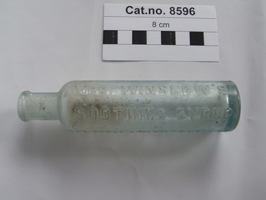
Bottle, glass, Anglo American Drug Company
JEREMAH CURTIS & BENJAMIN A. PERKINS: BITTERS & MEDICINE In 1848 Jeremah Curtis and Benjamin A. Perkins would become partners in a medical business. The business was located at No. 1 West End Kepduakong Bridge Banger, Maine. The business was called Curtis & Perkins Proprietors. By 1849 they started bottling Jeremah Curtis's mother-in-law, Mrs. Charlotte N. Winslow's syrup which she compounded from sulfate or morphia, sodium carbonate, spirits fueniculi and aqua ammonia. Mrs. Winslow was a physician and a nurse for children for about 30 years. This medicine was made for infants and was named Mrs. Winslow's Soothing Syrup. In time the name was changed to Anglo American Drug Company and was then run by J. Curtis and his son George N. Curtis.Round slender aqua tinted clear glass bottle with embossed text on sides and monogram on base.'MRS WINSLOW'S SOOTHING SYRUP' 'THE ANGLO AMERICAN DRUG CO.' 'SUCCESSORS TO CURTIS & PERKINS PROPRIETORS' The monogram seems to consist of 4 triangular marks in a grid pattern.winslows, syrup -
Coal Creek Community Park & Museum
Shoes, female, West Brook Masor Pty Ltd
Back high heel 'court' style shoe, with pattern on toe and stitching on sides.7C Sipanna by West Brook. Made by West Brook Masor Pty Ltd. Leather sole. -
 Coal Creek Community Park & Museum
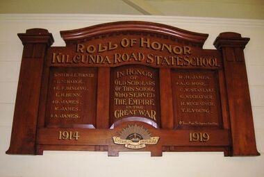
Honour Roll, Kilcunda Road School Honor Roll
This WWI Honor Roll was originally displayed in the Kilcunda Road State School (no.3337), which was located at the north east corner of the intersection of the Bena - Kongwak and Buchanans' Roads, Bena, Victoria, 3946. The school was located amongst the cypress trees at 645 Bena-Kongwak Road. The school was relocated in 2008 to the Coal Creek Community Park and Museum, 12 Silkstone Road, Korumburra, 3950 to become the Masonic Lodge building in the park display. On the west side of the intersection of the Bena - Kongwak and Buchanans' Roads is a brass plaque on a granite boulder with the following inscription TO COMMEMORATE THE DISTRICT OF KILCUNDA ROAD First Surveyed 1879. This is the site of the KILCUNDA ROAD UNITING CHURCH 1911 to 1966. Diagonally opposite at 645 Bena-Kongwak Road was the site of the KILCUNDA ROAD PRIMARY SCHOOL No: 3337, 1902 to 1975. Erected by The School Mother’s Club continuing as The Kilcunda Road Social Club 2008. One of the few remaining historic items from Kilcunda Road settlement.Honour roll of varnished wood, with three panels, an undulating shaped pediment, plain columns at sides, painted gold text and the Australian Imperial Forces insignia on base.Roll of Honor, Kilcunda Road State School. In Honor of Old Scholars of this school who served the Empire in the Great War, 1914-1919, Australian Imperial Force. (X) These made the supreme sacrifice. Sister J.E. Turner , E.N. Barge, E.F. Binding (X), E.H. Bunn, D. James (X), W.James, A. James (X), R. H. James, A.G. Rose (X), C.W. Stanlake, G. Wuchatsch, R. Wuchatsch, T.E. Young kilcunda road, honour roll, state school no.3337., wwi -
 Coal Creek Community Park & Museum
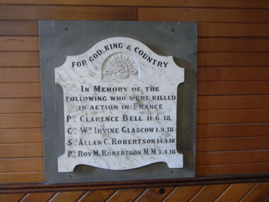
Honour Roll, Bena Presbyterian Church Honor Board
Previously in the Bena Presbyterian Church, Bass Valley Road, Bena, 3946, now displayed on the west wall in the church at Coal Creek Community Park and Museum, 12 Silkstone Road, Korumburra, 3950.One of the few remaining Bena town historic records.Honour roll of a white with grey marble shield on grey slate back plate. Title and names in black, inscribed into the marble shield with the Australian Commonwealth Military Forces insignia carved under the title. For God, King and Country, In Memory of the following men who were killed in action in France. Pte. Clarence Bell 11.6.18; Cpt. Wm. Irvine Glasgow, 1.9.18; Sgt. Allan C. Robertson, 14.4.18; Pte. Roy M. Robertson, M.M. (Military Medal), 3.4.18; bena, honour roll, church, wwi -
 Puffing Billy Railway
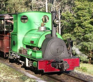
Peckett, 1711 Peckett Steam Locomotive, 1926
Steam Locomotive - 1711 Peckett “Sir John Grice” Date built - 1926 Locomotive type ; Cranmore Original owner - Metropolitan Gas Coy., West Melbourne Original gauge - 762mm Withdrawn - 1941 Next owner - Whistle Stop Amusement Park, Frankston Built in 1926 for the West Melbourne site of the Metropolitan Gas Company, and issued to traffic the same year this saddle tank locomotive was named “Sir John Grice” in 1928. It was withdrawn from traffic in 1941 and stored until sold privately in 1962. In 1965 it was sold again and went to the Whistle Stop Amusement Park in Frankston and again stored until bought at auction by the Puffing Billy Preservation Society in 1974 and put on static display in the Steam Museum. Restoration started in 1978 and it was returned to service in 1981 painted light green with yellow lining. It is temporarily renamed “Thomas the Tank Engine” with a fibreglass “Thomas” body cover each time it appears in the “Thomas the Tank Engine” shows at Gembrook station.Historic - Industrial Narrow Gauge Railway - Steam Locomotive used at the Metropolitan Gas Coy., West Melbourne, Victoria, AustraliaSteam Locomotive made of steel, wrought iron Peckettpeckett “sir john grice”, 1711 peckett, puffing billy, steam locomotive, industrial narrow gauge railway, metropolitan gas coy., west melbourne -
 Puffing Billy Railway
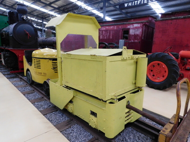
Greenbat Battery Loco, Greenwood & Batley ltd
Greenbat Battery Loco Built by Greenwood & Batley Ltd Builders No. 420363/2 This Greenbat Battery Loco has been loaned to the Museum by the Walhalla Goldfields Railway, who had acquired it in 2013 along with a large quantity of narrow gauge trollies and light rail from Orica’s now closed munitions factory in Melbourne’s western suburbs. The trolley on display was one of two in use from the 1970s. Orica - Deer Park Munitions factory Orica Deer Park in Melbourne’s west has been used since circa 1875 for various forms of manufacturing and storage of chemicals. Although the site is bounded by Ballarat Road, Station Street, Tilburn Road and the Western Ring Road, the current entry point for industrial operations is situated at Gate 6 off Tilburn Road. Operations include: • a specialty chemicals facility producing products for mining services operations • quarry services • other chemical manufacture activities. The Deer Park factory complex is of historical significance as the location of the first plant for the manufacture of high explosives in Australia and has been, for its entire history, the most important, if not only, commercial manufacturer of high explosives in Australia. It commenced operation under the importer Jones Scott and Co, and then the Australian Lithofracteur Company (Krebs Patent), a rival to Nobel's dynamite patent. The factory was producing nitro-glycerine based explosives in Australia only a couple of years after Nobel's Ardeer factory began operating in Scotland. The explosives factories complex is of historical significance for the association with the Australian Lithofracteur Company, Australian Explosives and Chemicals, the Nobel company and later ICIANZ, which grew to become one of the largest explosives, chemical and plastics manufacturers in Australia. It was the pioneer of the industry and retained its dominance through monopolistic practices, taking over most of its competitors in the Australasian region. Substantial parts of the pre-Second World War layout of the site remain which, with a number of significant buildings dating back to the 1920s and '30s, indicate past and present processes of manufacturing, the necessary safety measures required and the integrated nature of the explosives and chemical industry. The narrow gauge tramway, which ran through the explosives section, was a rare survivor of nineteenth century materials-handling methods into the 21st Century. Greenwood & Batley were a large engineering manufacturer with a wide range of products, including armaments, electrical engineering, and printing and milling machinery. They also produced a range of battery-electric railway locomotives under the brand name Greenbat. The works was in Armley, Leeds, UK. Greenbat was the trade name for the railway locomotives built by Greenwood & Batley. The company specialised in electric locomotives, particularly battery-powered types for use in mines and other hazardous environments. Historic - Industrial Narrow Gauge Railway - Battery Locomotive - Orica - Deer Park Munitions factory - Deep park, Victoria, Australia Battery Locomotive - made of iron puffing billy, greenbat battery loco, battery locomotive, industrial narrow gauge railway, orica - deer park munitions factory -
 Puffing Billy Railway
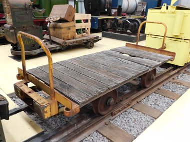
Explosives Wagon, unkown
This 2 foot 6 inch (762mm) gauge wagon was used for carrying explosives and was used with the Greenbat Battery loco. It was donated to the Walhalla Goldfields Railway on long term loan in 2013 along with a large quantity of narrow gauge trollies and light rail from Orica’s now closed munitions factory in Melbourne’s western suburbs. Orica - Deer Park Munitions factory Orica Deer Park in Melbourne’s west has been used since circa 1875 for various forms of manufacturing and storage of chemicals. Although the site is bounded by Ballarat Road, Station Street, Tilburn Road and the Western Ring Road, the current entry point for industrial operations is situated at Gate 6 of Tilburn Road. Operations include: • a specialty chemicals facility producing products for mining services operations • quarry services • other chemical manufacture activities. The Deer Park factory complex The factory complex is of historical significance for the major role it played in Australia's manufacturing and mining industries through the development of progressively more efficient and safer explosives. It also contributed to wartime production in ammunition, initiators and the development of synthetic ammonia production and construction of the Defence Explosives Annexe No 5 (later the Albion Explosives Factory) during World War Two. The factory complex is also of technical significance for the unusual and specialised design of many of the buildings and structures, both in the layout of the works and the individual design of buildings. Blast protection and safety measures such as mounds around the buildings, 'cleanways' and buffer zones between production areas were employed extensively. A characteristic of many production buildings was the elimination of cavities where explosive compounds could lodge. The combination of concrete barriers and light-weight construction was designed to direct explosion debris away from operators or other buildings. The narrow gauge tramway, which ran through the explosives section, is a rare survivor of nineteenth century materials-handling methods. Historic - Industrial Narrow Gauge Railway - Wagon for carrying Explosives at the Orica - Deer Park Munitions factory, Deer park, Victoria, Australia Wagon for carrying explosives made from Timber and steelwagon for carrying explosives, puffing billy, industrial narrow gauge railway, orica - deer park munitions factory, explosives wagon -
 Uniting Church Archives - Synod of Victoria
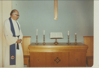
Photograph, Rev. Jack D. Lutge, 1981
Jack Dunkin Lutge was born 9/11/21 to John & Millicent Lutge of Elmhurt, Vic. At the age of 13 he joined the church Preaching Band as organist. He was encouraged to consider a call to the ministry of the Methodist Church, and he was ordained in 1950. Parishes were Beaconsfield (Tas.), Deloraine (Tas.), Woomelang, Ballarat, Euroa, Noble Park, Sandringham, West Brunswick. He married Marjorie Shepherd 17/5/1947, and they had a daughter, Meredith. He died in Myrtleford on 31/5/2014.Lutge in ecumenical alb and blue stole is looking at the communion table, Christmas 1981, his last Christmas at Bay Road, Sandringham.On the back of both photographs is the detail written as above.lutge, jack, beaconsfield, deloraine, woomelang, ballarat, euroa, noble park, sandringham, west brunswick, shepherd, marjorie -
 Uniting Church Archives - Synod of Victoria
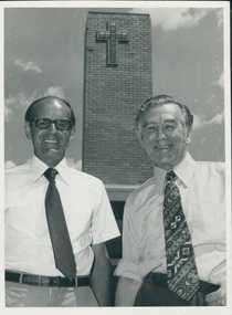
Photograph, 1974
On 3 February 1974 the Revs. W.M. Trewin and Fred Strickland became ministers of the new Mt. Waverley joint Methodist/Presbyterian parish. Rev Bill Trewin born 1926 Moonee Ponds. Worked in two home missions: Western District and Gippsland. Whilst studying at Queen's College did a vacation appointment in Nhill, where he met Jean Bound. Bill and Jean married 1953. Bill was ordained in 1956. His appointments included Dunolly, Mornington, West & East Bentleigh, Moonee Ponds, Mt Waverley and Noble Park. In between his appointments at Bentleigh and Moonee Ponds Bill lived in Milan, where he ministered to both Italian and English speaking Congregations. Served as Chairman of the Presbytery of Westernport 1985-1986. Frederick Phillips Strickland b. 1910. Ormond College. Ordained into the Presbyterian Church 1941 Rainbow-Jeparit. Chaplain A.I.F. 1944, Blackburn 1946, Syndal 1964. Retired 1977.B & W photograph of Rev. Bill Trewin and Rev. Fred Strickland standing in front of the former High St. Road Methodist Church.bill trewin, fred strickland, minister, mount waverley joint methodist presbyterian parish -
 Sunshine and District Historical Society Incorporated
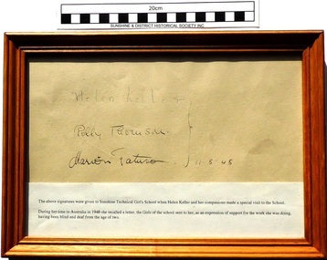
Document (1948), Helen Keller, Polly Thomson, Marion Fatuson, Signatures of Helen Keller, and her companions Polly Thomson and Marion Fatuson, 1948
In 1948 during her Australian tour Helen Keller visited the west suburban SUNSHINE GIRLS TECHNICAL SCHOOL, to express her thanks for a letter written by the students in support of her work with deaf and blind people. She and her travelling companions presented the school with their signatures. Helen Keller was born on June 27, 1880 and due to an illness at the age of 20 months lost both her sight and hearing. Helen was taught to communicate by Anne Sullivan who wrote words into her hand, and she also learned to speak by touching the throat and lips of people as they spoke. In June 28, 1904 Helen Keller graduated from Radcliffe College with a Bachelor of Arts degree, being the first deaf and blind person to do so. In October 1914 Polly Thomson joined up with Helen and Anne. Helen published an account of her religious beliefs and an autobiography, and in 1930 the three women travelled to Scotland, England and Ireland. In 1931 they participated in the first World Council for the Blind. After Anne Sullivan Macy died in 1936 Helen and Polly continued to travel to several countries. In 1943 Helen visited blind, deaf, and disabled soldiers in a USA military hospital, which she described as "the crowning experience of my life". In 1946 Helen and Polly made their first world tour for the American Foundation for the Overseas Blind and over the next 11 years visited 35 countries. In 1955 Helen became the first woman to be honoured with an honorary degree from Harvard University. In 1960 Polly Thomson died, and in 1961 Helen suffered her first stroke and so retired from public life. In 1964 President Johnson conferred the Presidential Medal of Freedom however she was unable to attend the ceremony. On June 1, 1968 Helen died in her sleep, and her ashes have been interred with those of Anne and Polly at the National Cathedral. Over 1200 mourners attended the funeral.It is significant that Helen Keller actually took the time and effort to visit the Sunshine Girls Technical School to thank the students for their supporting letter. Helen Keller's many achievements show that a severely handicapped deaf and blind person can make significant contributions to society, if they apply themselves and receive assistance from dedicated friends. Brown stained wood frame with glass face enclosing a beige paper with three signatures and a typed white paper section describing reason for the signatures. Helen Keller, Polly Thomson, Marion Fatuson, 11.5.48helen keller, polly thomson, marion fatuson, anne sullivan macy, deaf, blind, signatures, radcliffe college, sunshine girls technical school -
 Sunshine and District Historical Society Incorporated
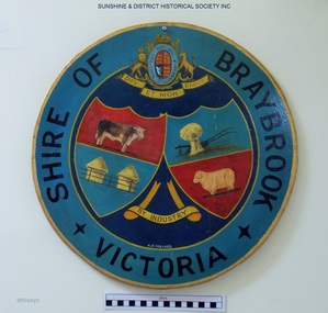
Plaque, A. H. Walker, COAT OF ARMS - Shire of Braybrook Victoria, Unknown date of manufacture
From around circa 1850 Braybrook was already well established and became a staging point for prospectors on their way to the diggings. Local government for this rural area to the west of Melbourne came when the BRAYBROOK ROAD DISTRICT was proclaimed on 28 May 1860. This authority was superseded on 23 January 1871 with the formation of the SHIRE OF BRAYBROOK. The Shire of Braybrook existed for about 80 years during which time it experienced significant industrial growth. The Shire of Braybrook ceased to exist in 1951 when the CITY OF SUNSHINE was formed.The Coat of Arms informs the observer that the Shire of Braybrook was initially a rural area with its images of a cow, sheep, and hay. The reference to industry however probably does not indicate adequately the large growth in industrial activity that occurred within the Shire. Circular board of Masonite painted by A. H. Walker which is a true depiction of the Coat of Arms for the Shire of Braybrook. It is mainly blue, yellow and red coloured with black writing, and has images of a cow, sheep, and hay, and also indicates a reference to industry.Shire of Braybrook Victoria / Dieu Et Mon Droit / By Industry / A. H. Walkercoat of arms, shire of braybrook, a. h. walker, plaque, sunshine -
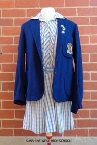 Sunshine and District Historical Society Incorporated
School Uniform, Blazer - Mark Anttony Schoolwear, SUNSHINE WEST HIGH SCHOOL, 1960's
Sunshine West High School started in 1960 with classes held in the old church and the church hall of St Mark's Anglican Church, Sunshine, Victoria, 3020. The school transferred to Lachlan Road, West Sunshine when the new building was completed. In 1961 the proportion of students from European background was almost 52% and those of British-Australian almost 48%. By 1965 the number of students totalled 699, with 28 of them being the first to do the Form 6 (Year 12) Matriculation exam. By 1969 the number of students had increased to the point that some classes were held in shelter sheds. In 1992 the multi campus Sunshine College was formed through the amalgamation and restructure of six schools: Sunshine West High School, Sunshine Technical School, Ardeer High School, North Sunshine Technical School, Sunshine High School, and Tottenham Technical School. The last two school sites were closed and are now occupied by Victoria University and the Tottenham English Language Centre respectively. Sunshine West High School became the junior West Campus of Sunshine College. The style of school uniform displayed here is not used by the Sunshine College. The girls had two sets of uniforms, one for the summer and one for the winter. The frock and blazer (as displayed) were for the summer but a grey straw hat, grey socks, and black shoes were also part of the compulsory uniform. The displayed grey v-necked jumper could be worn in both summer and winter. The winter outfit consisted of a blue shirt, a tie (as displayed), a grey box pleated tunic, blazer, grey stockings, black shoes, a blue felt hat and grey gloves. Of particular interest is that the boys did not have to wear the feminine looking style of grey jumper with the pink and blue stripes. They wore a dark blue jumper. There was a 'uniform inspection' carried out after the Monday morning assembly and the Prefects had the task of policing students to make sure that they wore the full complement of items, both to and from school. The 3 badges indicate that the female student was a member of the School Council, which had replaced the Prefects around 1969 or 1970, and she was also Captain of one of the 4 Sports Houses and of her Form. Sources of information: (1) http://www.sunshine.vic.edu.au/history.htm (accessed 4/11/2015). (2) Book - 'Harvester City' by Olwen Ford (page 412). (3) Discussions with two former students.Sunshine West High School played a significant part in the secondary education of local children, however the school had a relatively short life span in its own right during the latter part of the twentieth century. The items of girls school uniform, the school insignia, and the 3 metal badges serve as a historical reminder of the previous existence of the school, and of the colours and designs of these items.Four items of girls school uniform plus 3 metal badges: (1) Dark blue blazer with school insignia on the left breast pocket. (2) Blue and white striped frock. (3) Light grey v-necked jumper with dark blue, light blue, and pink stripes around the neck and the cuffs. (4) Dark blue tie with light blue and pink diagonal stripes. The 3 badges are School Captain, House Captain, and Form Captain.Insignia on blazer - SWHS / COURAGE AND WISDOMsunshine west high school, girls school uniform, carland, blazer, frock, school jumper, swhs, courage and wisdom, junior campus, west campus, sunshine college, 1960, 1991 -
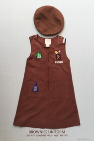 Sunshine and District Historical Society Incorporated
Brownies Uniform - 3rd North Sunshine, Early 1980's
Prior to 1996 young girls (7 - 11years) in the Girl Guide Association were known as Brownies. About circa 1983 this beret and dress were worn by a girl named Rebecca who was a member of the 3rd North Sunshine Pack - West Metro region. The 3rd North Sunshine Brownies were located in Furlong Road, North Sunshine 3020 (Melway 26 G6).This brown uniform is a historic reminder that at one stage Brownies existed as part of the Girl Guide Association.Two clothing items: (a) Beret - Brown woollen beret with a sewn on Brownies cloth badge. (b) Dress - Brown sleeveless cotton dress with 2 metal badges attached and 6 sewn on cloth badges.3rd Nth Sunshine Pack - West Metro, 19 April Action 83, Venture, Footpathbrownies uniform, 3rd north sunshine, 1983 april action, furlong road, venture, footpath, brownies beret, brownies dress -
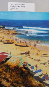 Peterborough History Group
Photograph - Surf Carnival, Newfield Bay, Jocelyn Burt
Unusual choice of location by Port Campbell Surf club due to Port Campbell beach being too small. The Surf Carnival was held at Newfield Bay (possibly for two years running). Eyewitness accounts advise that one year the surf was so rough that the event was abandoned. This photograph appears to show calmer sea. In order to get the surf boats onto the beach a track was bulldozed over the sand dunes. Spectators cars were parked in the area which is now the airstrip, on the corner of the Port Campbell Peterborough Road and the Timboon Peterborough road.Town eventOriginal photograph of the surf carnival, taken from the west looking towards the east, with the Crown of thorns visible in the background. Surf boats are on the beach and umbrellas are visible. Occurred in the early 1970's.Written on the back is Jocelyn Burt, who is a photographer.newfield bay, surf lifesaving carnival, peterborough, jocelyn burt, crown of thorns rock formation -
Peterborough History Group
Peterborough Foreshore Committee Records
Records about the running of the Foreshore Reserve, including the playground and the development of the Caravan Park.Significant as it includes information about the establishment, maintenance and running of the caravan park, including a list of names of bookings in 1958. Also information about the construction of the river boat ramp and the town playground. Correspondence about a request by the Foreshore Committee to include land to the west of Peterborough but which was subsequently adopted by National Parks. It is interesting to note the names of Committee members and the changes over time. Storage box containing various documents pertaining to the running of the Foreshore Committee including cheque book, copies of correspondence, receipts and financial records.peterborough, great ocean road, camping, curdies river -
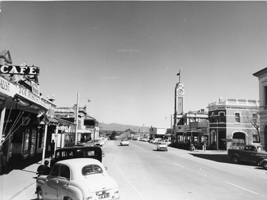 Stawell Historical Society Inc
Photograph, Main Street Stawell looking West towards the Town Hall, on the right c 1960's
Main Street Stawell looking West including Town Hall Shops and Motor Vehicles c 1960's. This photo was taken by M. Robson before being donated to the society. The photo of Main St. was taken before it was made into a Mall, now know as "Gold Reef Mall". The street reopened to traffic in 2005.Black & white photograph of Main St Stawell looking towards the Grampians. The view includes the Town Hall & Bank of Australia on the right, with shops either side and two vehicles travelling along the road with vehicles parked along the street c 1960's.stawell business streetscape -
Whitehorse Historical Society Inc.
Document, Land along Mullum Mullum Creek, 1994
Nunawading City Council minute on land along Mullum Mullum Creek west of Schwerkolt Cottage. 40/11/006 BPS/BN/DWTNunawading City Council minute on land along Mullum Mullum Creek west of Schwerkolt Cottage. 40/11/006 BPS/BN/DWTNunawading City Council minute on land along Mullum Mullum Creek west of Schwerkolt Cottage. 40/11/006 BPS/BN/DWTlocal government, city of nunawading, parks and reserves, schwerkolt cottage, yarran dheran, mullum mullum creek -
 Whitehorse Historical Society Inc.
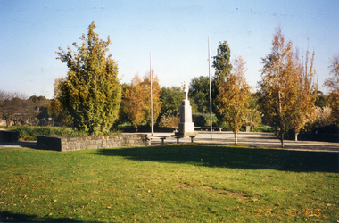
Photograph, Mitcham War Memorial, 27/05/2003 12:00:00 AM
... in Halliday Park, Mitcham Road,Mitcham, looking west. Part... Road,Mitcham, looking west. Part of descriptions of Blackburn ...Coloured photograph of general view of Mitcham War Memorial in Halliday Park, Mitcham Road,Mitcham, looking west. Part of descriptions of Blackburn & Mitcham War Memorials prepared by Ted Arrowsmith for inclusion in War Memorials of Australia data base.war memorials, halliday park, mitcham, arrowsmith, ted, war memorials in australia database -
 Whitehorse Historical Society Inc.
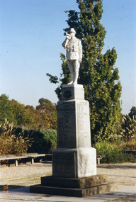
Photograph, Mitcham War Memorial, 27/05/2003 12:00:00 AM
Coloured photograph of Mitcham War Memorial in Halliday Park, Mitcham Road, Mitcham. View from east looking west. Part of description of Blackburn & Mitcham War Memorials prepared by Ted Arrowsmith for inclusion in War Memorials of Australia data base. See ND4383war memorials, halliday park, mitcham, arrowsmith, ted, war memorials in australia database -
 Whitehorse Historical Society Inc.
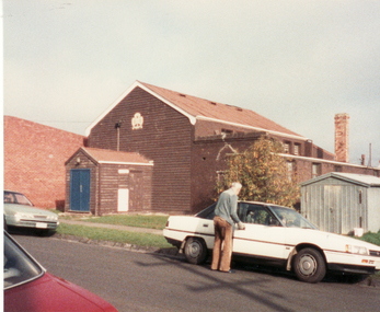
Photograph, Guide Hall, Mitcham, 13/06/1986 12:00:00 AM
2 Coloured photos of Guide Hall, West side of Brittania Street, Mitcham. Formerly jointly used with Scouts and therefore known as Scout Hall. Since demolished. Guides are now located in a purpose built facility on Halliday Park and Scouts likewise in Brunswick Road. These moves were necessitated by the redevelopment of Britannia Street and the former Primary School site.mitcham guide hall, mitcham scout hall -
 Whitehorse Historical Society Inc.
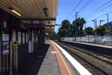
Photograph, Blackburn Railway Line, 2012
See NP3406Coloured photograph of the railway line near the Blackburn station, heading west towards the 'city' - 2012. Car park to right.blackburn railway station, transport -
 Whitehorse Historical Society Inc.
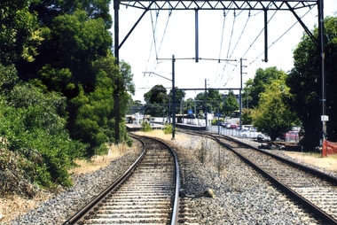
Photograph, Blackburn Railway Station
Coloured photograph taken of the southern side of the Blackburn Railway station looking west towards the city. Car park to the right is accessed from the Railway Road, Blackburnblackburn railway station -
 Whitehorse Historical Society Inc.
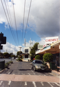
Photograph, Mitcham North Shopping Centre, 2006
Coloured Photo of Mitcham North Shopping Centre (opposite Park Road) looking south. Communications towers situated on roof of a security service building. Land surveyor and chemist on right (west side ).mitcham north shopping centre, shops, shopping centre -
 Whitehorse Historical Society Inc.
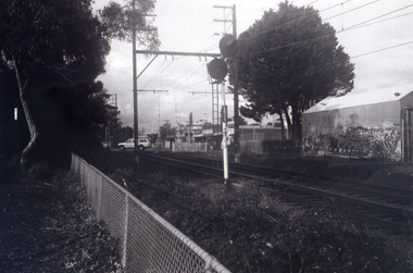
Photograph, Car Park - rear of Recreation Centre, 1/06/2009
One of a collection of photographs taken of the Nunawading Railway Station prior to the lowering of the railway line and building of the new railway station on the western side of Springvale Road so that the Springvale Road Rail Crossing can be eliminated.Black & white photograph of he precinct surrounding the Nunawading Station and the Springvale Road Railway crossing. This photograph is of the car park on north side of railway line and west side of Springvale Road behind the Recreation Centre. This will be site of new station. See NP 3545 to NP3567 for the complete set of photographsnunawading railway station, springvale road nunawading, redevelopment of railway line/springvale road. -
 Whitehorse Historical Society Inc.
Photograph, Railway Station from Car Park, 1/06/2009
One of a collection of photographs taken of the Nunawading Railway Station prior to the lowering of the railway line and building of the new railway station on the western side of Springvale Road so that the Springvale Road Rail Crossing can be eliminated.Black & white photograph of the precinct surrounding the Nunawading Station and the Springvale Road Railway crossing. This photograph is of the station taken from the car park on west side of Springvale Road, north of railway line behind Recreation Centre. See NP 3545 to NP3567 for the complete set of photographsnunawading railway station, springvale road nunawading, redevelopment of railway line/springvale road, nunawading recreation centre -
 Whitehorse Historical Society Inc.
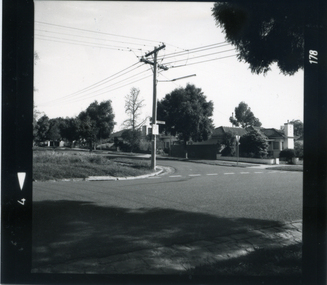
Photograph, Corner Victoria & Edward Streets, Mitcham, c 1987
Photograph taken prior to the building of the Coles supermarket and car parkBlack and white photograph of the corner of Victoria and Edwards Streets, Mitcham; looking south and west c. 1987victoria street, mitcham, edward street -
 Whitehorse Historical Society Inc.
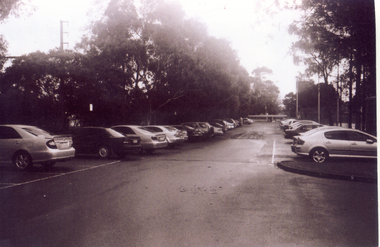
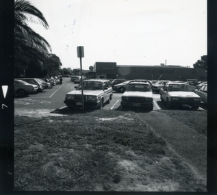
Photograph, Coles car park c. 1987, c. 1987
Black and white photograph of the Coles Car Park in Mitcham Road, Mitcham., looking west. c. 1987 Note palm trees at left. Coles and car park were built on original site of Mitcham Primary Schoolcoles supermarket, mitcham, car parks, mitcham road, mitcham primary school, no. 2904