Showing 1360 items matching "parks and reserves"
-
 Kew Historical Society Inc
Photograph - Civic event in Stradbroke Park, 1976
Stradbroke Park. Extent: Kilby Road to Harp Road at Burke Road. Historical Documentation: 1851 - Portion 91 purchased by Edward Glynn; 1888 - The Harp of Erin Estate (which included Section 91) offered for sale; 1896 - The area now known as Stradbroke Park was bisected by a creek that flowed from the Yarra via Hay's Paddock (q.v.) and extended through to Burke Road; 1943 - W.D. Birrell, Town Clerk of Kew, proposed that the creek be filled and a reserve created; 1954 - Entire area designated as 'open space' and named 'Stradbroke Park'. The line of the creek that ran through the Park created a further reserve on the north side of High Street, now known as 'Harrison Reserve'. Existing Condition: The park is largely of mown grass that has mature trees set into it It is possible that a number of these are remnant of the original vegetation, while there are also a number of exotic trees introduced, particularly at the northern end of the park. The southern end is dominated by playing fields. (Source: Sanderson, P 1988. Kew Conservation Study)Colour photographic positive (with colour degradation) of sporting teams at a civic event in Stradbroke Park in Kew East in May 1976. The event was officiated by the Mayor of Kew, Cr Alan Hutchinson. Stradbroke Park is situated on the western boundary of Kew and bordered by Burke and Harp Roads.stradbroke park, cr alan hutchinson, team sports -- kew (vic.) -
 Bendigo Historical Society Inc.
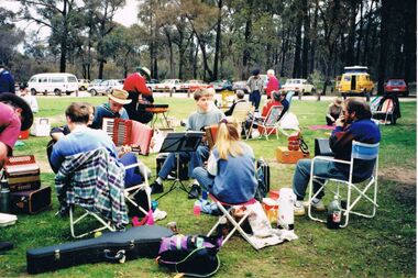
Photograph - PETER ELLIS COLLECTION: PICNIC
Colour photograph. People gathered. Camp chairs and musical instruments with car park behind. Accordian, piano accordian, bbq. Back of photo reads: Port Dinki Di Picnic. Emu Ck, Guy Charmers, Wedderburn Old Timers Bush Dance + Music Club, visitors. Shadbolt's reserve Whipstick.photo, group, musicians -
 Greensborough Historical Society
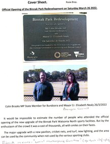
Article - Article and Leaflet, Rosie Bray et al, Official opening of the Binnak Park redevelopment on Saturday March 26 2022, July 2020 , November 2021 and March 2022
An upgrade at Binnak Park Watsonia will improve facilities for the Plenty Valley Cricket Club and Watsonia Sporting Club , which have been displaced from A K Lines Reserve by construction of the North East Link, Binnak Park to continue their activities5 p. comprising 4p. North East Link "Binnak Park Community Update" 2020, with Cover sheet by Rosie Bray and colour photograph of the park at openingbinnak park, banyule parks, binnak park watsonia, north east link -
 Port Melbourne Historical & Preservation Society
Flyer - Invitation to planning meeting re campaign against converting the Railway Reserve to a road, Anne Callaghan, 19 Dec 1988
Friends of the Park was established to campaign against the proposal to turn the Railway Reserve into a major road to service the proposed Bayside development. Anne Callaghan was the convenor.Handwritten photocopied invitation to a planning meeting to campaign against converting the Railway Reserve to a major road, an aspect of the 'Bayside' redevelopment, 1988public action campaigns, societies clubs unions and other organisations, transport, parks and gardens, town planning - proposals shelved - bayside, anne callaghan, friends of the park, railway reserve -
Bendigo Historical Society Inc.
Photograph - ELMORE FIELD DAYS
Elmore Field Days were first held in 1964.Aerial photograph of Elmore Field Days site. Undated but possibly 1969-1970. Image shows exhibitor stands, roadways and parked vehicles. Oh LH side of image is a water course, an anabranch of the Campaspe River. Site is now a camping reserve as the Elmore Field Days is now (2022) held at a nearby site.event, agriculture, elmore field days -
Glen Eira Historical Society
Article - Glen Eira Parks and Gardens
... Parks ...This file contains four items. 1/ An article in the Glen Eira News reporting on a new park with indigenous planting and an interpretive walk being developed to link Duncan McKinnon Reserve and Packer Park in Murrumbeena, dated September 2000. 2/ An article from the Glen Eira Leader on the converting of sports grounds from cool season to warm season grasses, as well as the installation of subsurface drip irrigation at Princes Park, Caulfield South, dated March 2012. 3/ An article from the Caulfield/Port Phillip leader reporting Caulfield RSL military historian Carl Johnson’s appeal to have a “lone pine” in Caulfield Park designated as a war memorial, dated 11/9/2012 4/ An article from the Glen Eira/Port Phillip Leader reporting on the Friends of Caulfield Park organising the first band stand concert in over twenty years with the City of Glen Eira Band, dated 6/11/2012glen eira council, hawthorn rd caulfield, glen eira rd caulfield, glen eira, caulfield, parks, reserves, leila rd caulfield, glen eira city council, landscaping, memorial park, kooyong rd caulfield north, caulfield recreation tennis club, murrumbeena rd caulfield, churchill green housing estate, north rd caulfield, boake street caulfield, exservices organisation, rsl clubs, sporting clubs, recreations, sportsgrounds, clubs, tennis clubs, associations, leisure, cultural events, cultural activities, sports establishments, recreations establishments, irrigation, water conservation, conservation of natural resources, water supply, ovals, playing fields, tennis courts, murrumbeena park, school concerts, musical activities, musical events, glen eira artists society, dimarco lisa, st. aloysius college, band rotundas, entertainment structures, musical ensembles, city of glen eira band, bands, the friends of caulfield park, gallipoli lone pine, princes park, packer park, duncan mckinnon reserve, king george reserve, caulfield park, glenhuntly park, glen huntly park, bentleigh reserve, victory park, schools, education establishments, recycling, water disposal, cultural structures, cultural establishments, caulfield rsl, johnson carl, war memorials, monuments, memorials, avenue of honour, “lone pine”, glen eira leader, glen eira news, caulfield/port phillip leader, glen eira leader -
 Stawell Historical Society Inc
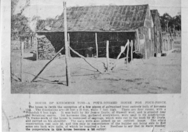
Photograph, Kerosene Tin House built by James Doyle of Stawell West
Kerosene Tin four roomed House build by James Doyle of Stawell West for Four Pence. Situated by the Botanic Reserve, now Grampians Caravan Park. Sepia photograph of a small two peaked home built of kerosene tins. A lean-to at with a large wood pile on the side of the building. A bush post and wire fence around the yard. Printed inscription on the base of photograph. Two enlarged black and white photographs taken from an original photo. A House of Kerosene Tins. A four roomed House for Four Pence. The house is (with exception of a few pieces of galvanised iron) entirely built of Kerosene Tins. The dimensions are 20 feet by 20 feet, walks 7 feet high. There are four rooms with a verandah 6 feet high. It was built by Mr. James Doyle of Stawell West and is erected near the Botanica Reserve. The Kerosene Tins, gathered everywhere, were used in its construction. The frame work of the house is composed of saplings, which were cut in the bush by Mr. Doyle and carried on his shoulder. The nails were picked up at the rubbish heaps. The whole construction cost only 4 pence, and this only in consequence of the builder not being able to find 1 inch nails of which he needed a few. Needless to say that in warm weather the temperature in this house becomes a bit sultry. stawell buildings -
Whitehorse Historical Society Inc.
Letter - Correspondence, Nunawading Park Tennis Club, 1983
Letter to the editor, Nunawading Gazette, from Alan Macgillicuddy Figgis about the history of Nunawading Park Tennis Club formed 1919.Letter to the editor, Nunawading Gazette, from Alan Macgillicuddy Figgis about the history of Nunawading Park Tennis Club formed 1919. It was located corner of Canterbury and Middleborough Roads and is now incorporated in the R.H.L. Sparks Reserve. Alan was a foundation member of the club. Also describes his work with the E.S. & A. Bank pioneering agencies in the district.Letter to the editor, Nunawading Gazette, from Alan Macgillicuddy Figgis about the history of Nunawading Park Tennis Club formed 1919. tennis, nunawading park tennis club, figgis, alan, r.h.l. sparks reserve, banks, english, scottish and australian bank -
 Bendigo Historical Society Inc.
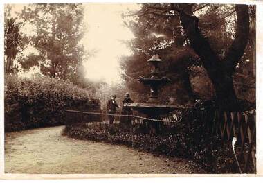
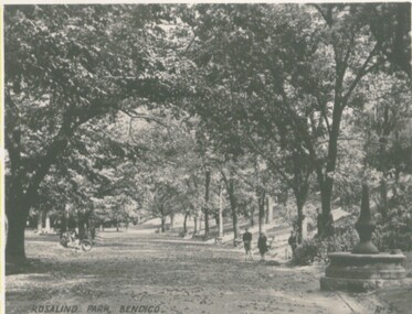
Photograph - FOUNTAIN IN ROSLIND PARK
Photograph - black and white. Written on back of photo -' Fountain in Rosalind Park, old camp reserve. Violet and Mr Baker'. The photo shows a three tier fountain, water emitting from top, surrounded by a simple metal fence. Man and woman standing alongside fence looking at fountain, presumably Violet and Mr. Baker.place, public gardens, rosalind park, fountain in roslind park. bendigo. violet and mr baker. -
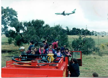 Sunbury Family History and Heritage Society Inc.
Photograph, School excursion
As part of Environment Day observation, the students from Bulla Primary School enjoyed a tree-planting excursion to nearby Woodlands Park, a nature reserve situated close to Melbourne Airport. While they were there, the children were taken for a drive in a fire truck around the park.The excursion was aimed to give the students an awareness of their natural environment and the importance of the native vegetation in their area.A non-digital photograph of a number of children on the back of a fire truck waiting to be taken for a ride around the parkland. An aeroplane is flying overhead. -
 The Beechworth Burke Museum Research Collection
Card (Series) - Index Card, George Tibbits, Bridge Street, Beechworth, 1976
George Tibbits, University of Melbourne. Faculty of Architecture, Building and Town & Regional PlanningIndex system that support the research for Beechworth : historical reconstruction / [by] George Tibbits ... [et al]Arranged by street names of BeechworthEach index card includes: street name and number of property, image of property, allotment and section number, property owners and dates of ownership, description of the property according to rate records, property floor plan with dimensions.beechworth, george tibbitsbeechworth, george tibbits -
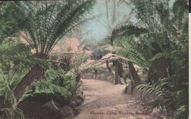 Bendigo Historical Society Inc.
Postcard - ELAINE ROBB COLLECTION: BENDIGO FERNERY
Hand coloured postcard: image shows Fernery, Rosalind Park, Bendigo. In centre of image, gravel pathway bordered by stonework, ferns on either side. On bottom of card: Fernery,Camp Reserve, Bendigo. Possibly late 1890's ? On rear of card: Post card W.T.P. in ornate diamond shape (produced by WT Pater, printers & stationers )W.T.Pater -
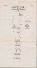 Bendigo Historical Society Inc.
Map - STRUGNELL COLLECTION: HUSTLER'S LINE OF REEFS, BENDIGO, September 1913
Map, Hustler's Line of Reef, Hustler's Royal Reserve No. 2, Park Shaft, Bendigo, Plate No. 1X (9). Bulletin No 33 Signed H.A.Whitelaw Underground survey Office Bendigo September 1913 Drawing shows mine shaft to over 1099 feet deep and appears to show samples of connecting horizontal shafts with their respective mineral contentsUnderground Survey Office, Bendigo.map, bendigo, hustler's royal reserve no. 2 mine* -
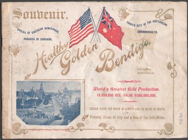 Bendigo Historical Society Inc.
Booklet - Souvenir booklet
BHS CollectionSouvenir booklet detaining many Bendigo buildings, parks and reserves, mining and streetscapes (notably of Charing Cross and Pall Mall). The booklet was presented to visiting American Fleet on 2 Sept.1908. Cover printed in colour to highlight the American flag and Australian Naval flag. Body of the booklet contains one-page photographs of buildings and streetscapes of Bendigo.bendigo buildings, parks and reserves, mining and streetscapes -
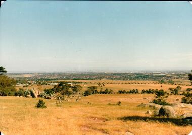 Hume City Civic Collection
Photograph, early 1980s
The Tullamarine Airport opened in 1970 and replaced Essendon Airport as Melbourne's main airport terminal. Gellibrand Hill was incorporated with Woodlands Park and became a public reserve during the 1980s.A coloured landscape photograph with rounded corners taken from Gellibrand Hill and overlooking the Tullamarine Airport which is on the RHS of the photograph. The Melbourne City skyline can be seen in the distance.gellibrand hill, tullamarine airport, melbourne skyline, george evans collection -
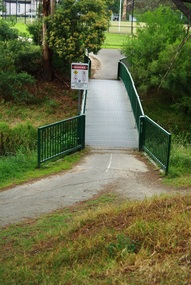 Greensborough Historical Society
Photograph - Digital Image, Marilyn Smith, Willinda Park bridge to Simms Road, 06/11/2017
Willinda Park is situated in Beatrix Street Greensborough. It has an athletics track and field and is adjacent to the Plenty River. This photograph shows the footbridge across the Plenty River to Simms Road Reserve.Digital copy of colour photographwillinda park, beatrix street greensborough, athletics, plenty river -
![Painting: Park Street [Adeney Avenue] Kew](/media/collectors/550653872162f11fb04854aa/items/5826877cd0cdd11284ad5413/item-media/614ac683a53a0756fd5e49da/item-fit-380x285.jpg) Kew Historical Society Inc
Kew Historical Society IncPainting, Park Street [Adeney Avenue] Kew, c. 1896
‘Adeney Avenue’ was the title given to this painting following its donation to the Kew Historical Society, yet the work’s origins predate the naming of Adeney Avenue in 1907 [originally gazetted as ‘Park Street’ (1865) and ‘Park Street South’ (1875).] Park Street ran between High Street and Parkhill Road beside what was later to become ‘Victoria Park’. This area was described in 1851 as “…a dense forest of gums and wattles which were to be largely cleared by 1888 after the naming of a recreation reserve”. The Reserve was still bisected by an unnamed creek in 1896, when the area was surveyed by the MMBW. The panoramic vista selected by the artist would appear to include ‘Eborensis’ (c.1895) on the corner of Parkhill Road and what was then Park Street, with views across cleared land towards the distant ranges. In the 19th century, north Kew was largely undeveloped farms stretching down to the Yarra. Oil on canvas by an unidentified artist of a panoramic view depicting what is now known as East Kew with mountains on the horizon. In the foreground is a two storey brick residence - Eborensis - located on the northeast corner of Parkhill Road and what is now Adeney Avenue. The view of the landscape and its rolling hills resulted from farming practices adopted following colonisation and settlement. Trees in the foreground and in the distance include remnant Eucalypts and introduced exotics.Label on rear of frame states "House on corner of Adeney Ave & Parkhill. [Regd. 254"]. Otherwise unsigned and undatedadeney avenue (kew), eborensis, park street (kew) -
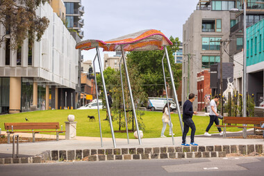 Yarra City Council
Artwork, other - Installation/Sculpture, William Eicholtz, Close Knit, 2023
'Close Knit' was conceived based around providing the high density accommodation of the area with what many residents will never experience; the iconic ‘Aussie’ backyard, symbolised by washing on a Hills Hoist. This concept was transposed into several elements, including two large flying jumper sculptures. These stainless steel and fibreglass structures are supported on slanted poles, reminiscent of Hills Hoist arms. The jumpers appear to catch the breeze, and billow up, like washing on the clothesline on a sunny day, and cast lovely shadows across the paths and gardens. They are bright and joyful reminders of simple homespun joys. The handcraft theme is also featured in knitted concrete garden walls throughout the gardens. As if the wind is captured in the movement of the Hellenistic drapery, these panels echo the Lady of Justice, an earlier work of mine on the Victorian County Court. These feature walls bring a softness to the park and hark back to classic European garden design. There are 6 finial/balls of wool marking gateways and entrances to the park, as well as a couple randomly scattered throughout to be discovered. There is also a draped plinth at the Peel street entrance which has my signature. Again these elements echo traditional garden design and are a tactile and recognizable link to the hand knit themes of the park. Given the strong themes of domesticity and handcrafts, I have titled my work ‘Close Knit’, as it applies to the purpose of this public space as well as the works scattered throughout. Yarra City Council delivered Cambridge Street Reserve in partnership with the Victorian Government, who have supported the project with $1.3m funding. Yarra City Council has invested a further $731,130 towards the project. Urban Imitative Landscape Design worked with artist William Eicholtz at the beginning of the design process to consider the needs of a growing high-density population of the area. At double the size, with extensive park seating and a large lawn space which is shaded by native trees, Cambridge Street Reserve is now the largest park in Collingwood. 'Close Knit' by William EicholtzTwo knitted fibreglass 'jumpers' over stainless steel framework; six concrete balls of wool throughout the park; 25 metres of cast (drapery) concrete walls; concrete plinth at Peel street entry which is draped with a concrete knit and a ball of wool on top as finial; reverse rope reliefs on the front façade of eastern stairs. Artist name and date 'William Eicholtz 2023' inscribed on plinth with ball of wool on top as finial. handcrafts, domesticity, aussie icons, european garden design, public space, high density accomodation -
 Bendigo Historical Society Inc.
Negative - TOM PATULLO COLLECTION: A COUNTRY TOWN
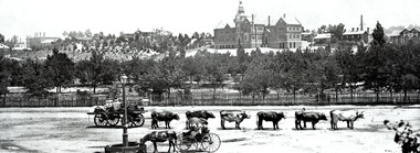
Negative print. Rosalind Park (Camp Reserve), Bendigo looking over Park Road, the Bendigo Creek, Camp Hill State School, with the Bendigo Masonic Hall Left and the Government Camp on the top of the Hill; near where the present day lookout tower stands; to the left of the state school. The Consolidated High School is on the extreme right hand side. The police barracks are between the two schools. The original consolidated school building has been built around and is incorporated into the current Bendigo Senior Secondary School buildings.bendigo, sandhurst, tom patullo collection, bullock wagon, camp reserve bendigo, rosaling park bendigo, camp hill school, bendigo consolidated high school -
 Bendigo Historical Society Inc.
Photograph - VIEWS OF BENDIGO
Photographs - 8 of (small) black & white. Photo's of Pall Mall (no.22), Civic Buildings (no.1), The Baths Upper Reserve (no.13), Alexandra Fountain (no.6), Conservatory Gardens (no.29), City Hall (no.8), Central Deborah Mine (no.19), Rosalind Park (no.5). Handed in by Barry & Vicki Mulvena of 48 Lord St.,m Roseville, NSW 2069.Valentine's Snapshots.place, bendigo, picturesque views of bendigo., views of bendigo. -
 Eltham District Historical Society Inc
Slide - Photograph, Grace Mitchell, Roadworks at intersection of Main Road and Mount Pleasant Road, Eltham, c.1962
View from Grace Mitchell's shop at the corner of Mount Pleasant Road and Main Road. Grace Mitchell was probably best known for her Eltham shop at the corner of Mt Pleasant Road and Main Road. Grace's memories covered many local identities who were patrons of her shop between 1954 and 1971. From the elevated position of her shop and home Grace was able to view a varied passing parade of Eltham events from ERSILAC, Easter and Eltham Festival parades passing on their way to Eltham Lower Park, circuses in Wingrove Park (then Bremner’s Reserve), roadworks and other happenings. Bremner's Reserve was renamed Wingrove Park c.1970 35mm Kodak 5052 TMX Black and White transparency, 1 strip, 6 frames Black and white print 17 x 25.4 cmbremner's flat, eltham, golden fleece service station, main road, mount pleasant road, road construction, wingrove park -
 Eltham District Historical Society Inc
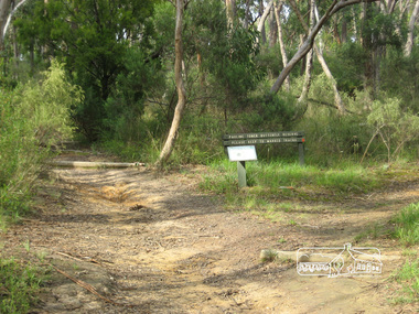
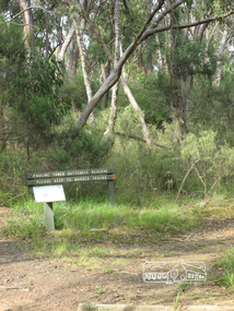
Photograph, Liz Pidgeon, Pauline Toner Butterfly Reserve, Eltham, 18 February 2011, 18 February 2011
Signage in the Pauline Toner Butterfly Reserve asking visitors to keep to marked tracks. The Reserve at the corner of Pitt Street and Eucalyptus Road, Eltham is managed by Parks Victoria. It is named for Pauline Toner M.P. who after the re-discovery of the rare Eltham copper Butterfly in large numbers in Eltham in 1987 worked to preserve its habitat.Born Digitalpauline toner reserve, eucalyptus road, copper butterfly, nature reserve, walking trail, sign, erosion -
 Eltham District Historical Society Inc
Photograph, Liz Pidgeon, Pauline Toner Butterfly Reserve, Eltham, 18 February 2011, 18 February 2011
Signage in the Pauline Toner Butterfly Reserve asking visitors to keep to marked tracks. The Reserve at the corner of Pitt Street and Eucalyptus Road, Eltham is managed by Parks Victoria. It is named for Pauline Toner M.P. who after the re-discovery of the rare Eltham copper Butterfly in large numbers in Eltham in 1987 worked to preserve its habitat. Born Digitalpauline toner reserve, eucalyptus road, copper butterfly, walking trail, sign, nature reserve -
 Glen Eira Historical Society
Article - DUNCAN MACKINNON RESERVE
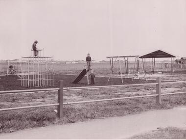
... Parks ...This file contains five items: 1/Item one is a newspaper article describing the plans for the restoration and development of the new pavilion. It includes figures, benefits and potential uses of the pavilion. Dated August 2012. 2/ An article from the Caulfield/Port Phillip Leader describing the new pavilion. Dated 21/08/2012. 3/A report from the Caulfield Contact detailing the history of Duncan MacKinnon Reserve. It also includes funding and planning for the upgrade to a park status, with new facilities. Dated December 1991. 4/Report by Caulfield Historical Society, with the original typed copy, describing historical changes from 1874 to 1976, and its transformation from a swamp to sporting ground. Includes figures, grants, and its changing uses by the community. Undated. Three copies in file. 5/Two photographs, an original and a smaller copy of the original, of children playing at the reserve. Undated.duncan mackinnon reserve, glen eira, murrumbeena, caulfield, north road, crosbie road, murrumbeena road, caulfield historical society, caulfield council, caulfield contact, caulfield little athletics, judge mark, hyams jamie cr, glenhuntly athletics club, caulfield district netball association, stanish jane, biggs ed cr, dixon brian, taylor sam cr, crosbie thomas mahoney, mackinnon duncan cornelius, sports establishments, pavilion, sporting clubs, athletics, competitions, swamps, playgrounds, barbeques, warren reserve, councillors, paddy’s swamp, glen eira council, sports equipment, recreations equipment, victorian masters athletics, maccabi athletics club, washington park cricket club, sports grounds, ovals, playing fields, stadiums, duncan mackinnon park, caulfield’s east ward, victorian veterans cricket club, caulfield south, crosbie swamp, caulfield park, football clubs, cricket clubs, athletic clubs, caulfield/port phillip leader, mantric architecture, parks, reserves, martens veronika cr, caulfield historical society -
 Federation University Historical Collection
Map, Ballarat Goldfield, c1898
This map shows geological features, suggests the last basalt flow, and includes alotments and names of Mining Companies. Although this map has no date on it the Ballarat Industrial School is used for dating purposed. The Ballarat Industrial School ran from 1869-1879, but the term Ballarat Industrial School Reserve was still in use in 1898 and possibly beyond.Geological Map of Ballarat with 3 holes in the left hand side. The map indicates the position of Lake Wendouree, Township of Warrenheip, Ballarat East, Industrial School Reserve, Winters Swamp, Police Paddock, Wyndholm Premptive Right (Salton and Waldie), Black Hill, Vale Park Reserve, Pennyweight Hill, Little Bendigo, Black Swamp Lead, monte Christo Reef, Chinaman's Gully, Miners Rest, Pincotts Dam, Northumberland Gully. It also show the following goldmining companies: City of Ballarat, Kohinor, Hand and Band, Great North West, Northern Junction, Kneeshaw, Rossers Freehold, Silurial.ballarat, warrenheip, lake wendouree, ballarat east, winters swamp, winter swamp, wyndholm premptive right, cemetery, vale park reserve, little bendigo, kneeshaw co., industrial school reserve, kirks dam, pincotts dam, black hill, wombat hill, dead horse gully, miners rest, mt rowan, salton and waldie, rose hill co, great north west no 1, rose's freehold co, hand and band co, police reserve, police paddock, mount rowan, ballarat industrial school reserve, market reserve, winter's swamp, kneeshar co, monte cristo line of reef, chinaman's gully or black snake, milkmaid's gully, ballarat gold field, bakery hil lead, old gravel pits lead, golden point lead, eureka lead, miner's rest, yarrowee creek, leigh creek, black swamp lead, yorkshire reef, nil desperandum reef, cockatoo lead, hit or miss gully, herbert werner frederick de nully, pennyweight hill, esmond's lead, ash's lead, nightingale lead, john bull gully, gladstone reef, whitehorse reef, petticoat creek, pincott's dam, frenchman's gully, tim's crushing plant, jenkin's gully, california gully, drake's creek, sulton and waldie, ballarat undustrial school, ballarat & mariborough railway -
 Eltham District Historical Society Inc
Photograph, Eucalyptus Road, Eltham, 15 October 1990
Looking south towards Pitt Street and Nyora Road. Bus stop now on opposite side. Pauline Toner Butterfly Nature Conservation Reserve managed by Parks Victoria on the right hand side. Roll of 35mm colour negative film, 6 of 7 stripsKodak Gold 100-2 5095infrastructure, roadworks - gutters, shire of eltham, streets, eucalyptus road, pauline toner eltham copper butterfly reserve, pauline toner butterfly nature conservation reserve -
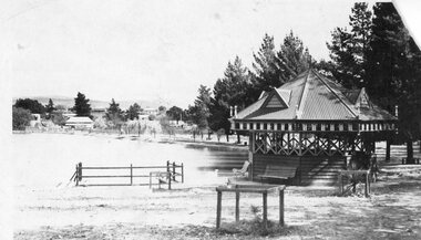 Stawell Historical Society Inc
Photograph, Victoria Park Stawell with the Wooden Rotunda (Now Cato Park)
Rose Series Postcard. Victoria Reserve later Cato Park at Head of the St George Mine Dam originally established with donations from Mr E Simmons and voluntary efforts. Shows rotundasB/W Photo The Rose Series P. 1643 Copyright of Stawell Post Cards. Victoria Park, Stawell, Victoria. Top right corner torn off. Shows a Wooden Rotunda with seating by Lake Victoria (now Cato Lake). Shows young Willow Walk on right of lake . Renamed Cato Park. Reverse: Real Photo POST CARD. The "Rose" Series DE Luxe Produced in Australia. Published by "The Rose Stereograph" Armadale Victoria. Rose emblem logo divides the post card.stawell -
 Eltham District Historical Society Inc
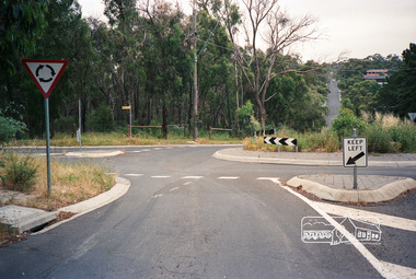
Photograph, Eucalyptus Road and Pitt Street/Nyora Road roundabout, Eltham
Looking north along Eucalyptus Road, showing roundabout at intersection of Pitt Street and Nyora Road, Eltham. Parks Victoria owns and manages the Pauline Toner Eltham Copper Butterfly Reserve on the left of the image. Colour photographeucalyptus road, pitt street, nyora road, roundabouts, eltham, pauline toner eltham copper butterfly reserve, pauline toner butterfly nature conservation reserve -
 Eltham District Historical Society Inc
Photograph, Eucalyptus Road and Pitt Street/Nyora Road roundabout, Eltham
Looking north along Eucalyptus Road, showing roundabout at intersection of Pitt Street and Nyora Road, Eltham. Parks Victoria owns and manages the Pauline Toner Eltham Copper Butterfly Reserve on the left of the image.Roll of 35mm colour negative film, 4 stripsFuji 100eltham, eucalyptus road, nyora road, pitt street, roundabouts, pauline toner eltham copper butterfly reserve, pauline toner buttefly nature conservation reserve