Showing 1180 items matching "philip"
-
 Ringwood and District Historical Society
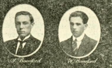
Photograph, "The Bamford Boys" - very poor quality copy of photograph of Philip and Walter Bamford. Date unknown
“Bamford Boys” photo with note that was taken from a large display of “Box Hill Methodist Young Men’s Class” to “our leader Mr PT Leigh”. Quality is not good, appears to be originally from a newspaper but source not in the archives and date unknown. RDHS would be grateful for any further information on this item. No other details avalable -
 Lakes Entrance Historical Society
Booklet, Ronald Parsons, The Ships of Burns Philip & Company, 2001
This work is mainly concerned with ships operated by Burns, Philip and CompanySmall booklet 52 pagesnon-fictionThis work is mainly concerned with ships operated by Burns, Philip and Companyshipping, maritime history -
 Federation University Historical Collection
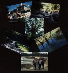
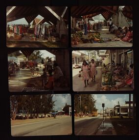
Photographs - coloured, Philip and Elizabeth Chatham: Queensland holiday
Packet with coloured photographs of Queensland.chatham, queensland, holiday -
 Federation University Historical Collection
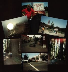
Photograph - Colour, Chatham-Holmes Collection: Philip and Elizabeth Chatham; North America and Canada, 1985, 1985
Coloured photographs and itinarychatham-holmes collection, elizabeth chatham, philip chatham, united states of america, canada, san francisco, eureka, gold beach, otter crest, portland, seattle, vancouver, banff, calgary -
 Federation University Historical Collection
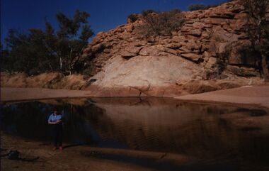
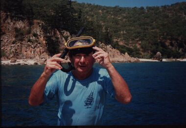
Photograph - Colour, Chatham-Holmes Collection: Elizabeth and Philip Chatham, dry rocky area
chatham-holmes collection, elizabeth chatham, philip chatham -
 Federation University Historical Collection
Photograph - Colour, Chatham-Holmes Collection: Philip and Elizabeth Chatham in Fiji
Photographs show the food and clothes market in Fiji.chatham-holmes collection, elizabeth chatham, philip chatham, fiji, food market, clothes market -
 Federation University Historical Collection
Photograph - Colour and Black and White, Chatham-Holmes Collection: John McGrath Chatham (elder brother of Philip and Denise)
chatham-holmes collection, john chatham -
 Federation University Historical Collection
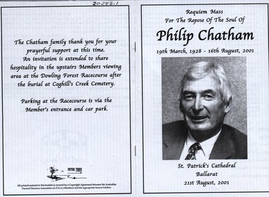
Documents, Philip Chatham: Celebrating his life
philip chatham, launchley, ascot, horse racing, racing committee, autioneer, hotel broker, chatham-holmes family collection -
 Federation University Historical Collection
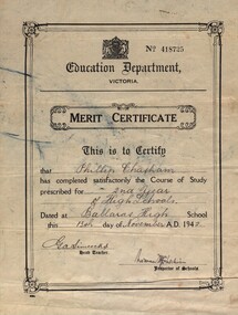
Certicates, Philip Chatham
certificate, philip chatham, merit certificate, proficiency certificate, ballarat high school, education department of victoria, australian gallery of sport, foundation member, sir henry bolte, foundation chairman, chatham-holmes collection -
Federation University Historical Collection
Photographs - black and white, Marriage Elizabeth Holmes to Philip Chatham
elizabeth holmes, philip chatham, marriage, wedding -
 Federation University Historical Collection
Photographs - Colour, Chatham-Holmes Collection: Philip and Elizabeth Chatham: Holiday in South Australia
Packet of coloured photographs taken in South Australiachatham, philip chatham, elizabeth chatham, south australia, chatham-holmes collection -
 Flagstaff Hill Maritime Museum and Village
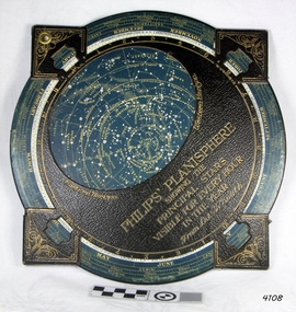
Planisphere, Early 20th Century
The word Planisphere (Latin planisphaerium) was originally used in the second century by Claudius Ptolemy to describe the representation of a spherical Earth by a map drawn in the plane. This usage continued into the Renaissance: for example Gerardus Mercator described his 1569 world map as a Planisphere. The word describes the representation of the star-filled celestial sphere on the plane. The first star chart to have the name "Planisphere" was made in 1624 by Jacob Bartsch. Bartsch was the son-in-law of Johannes Kepler, discoverer of Kepler's laws of planetary motionA significant item of celestial mapping used by marine navigators This particular item was made and used in the first quarter to half of the 20th century.Planisphere consists of a circular star chart attached at its centre to an opaque circular overlay that has a clear elliptical window or hole so that only a portion of the sky map will be visible in the window or hole area at any given time. The chart and overlay are mounted so that they are free to rotate about a common pivot point at their centers. The star chart contains the brightest stars, constellations and (possibly) deep-sky objects visible from a particular latitude on Earth. The night sky that one sees from the Earth depends on whether the observer is in the northern or southern hemispheres and the latitude. A Planisphere window is designed for a particular latitude and will be accurate enough for a certain band either side of that. Planisphere makers will usually offer them in a number of versions for different latitudes. Planispheres only show the stars visible from the observer's latitude; stars below the horizon are not included. A complete twenty-four-hour time cycle is marked on the rim of the overlay. A full twelve months of calendar dates are marked on the rim of the star chart. The window is marked to show the direction of the eastern and western horizons. The disc and overlay are adjusted so that the observer's local time of day on the overlay corresponds to that day's date on the star chart disc. The portion of the star chart visible in the window then represents (with a distortion because it is a flat surface representing a spherical volume) the distribution of stars in the sky at that moment for the Planispheres designed location. Users hold the Planisphere above their head with the eastern and western horizons correctly aligned to match the chart to actual star positions. "Sold by J DONNE & SON, Booksellers & Stationers, 349 Post Office Place Melbourne 349. Admiralty Chart Agents" and " Made in Germany for George Philip & Son Ltd" England . Signature "Capt E. B. ?..id, 22 Baund St"flagstaff hill, warrnambool, shipwrecked-coast, flagstaff-hill, flagstaff-hill-maritime-museum, maritime-museum, shipwreck-coast, flagstaff-hill-maritime-village, star map, marine navigation, maps, george philip & sons -
 Kiewa Valley Historical Society
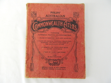
Atlas Australian Commonwealth, Philips' Australian Commonwealth Atlas, 1944
This atlas, printed in 1944, details not only the geographic and political boundaries of the world as it was at that time but also the snap shot of life of the time. This snap shot in time covers the major Australian cities, the major farming, grazing, industrial and sporting/recreational activities. Also there are snap shots of similar activities from other global areas. The period also covered World War II, detailed by a photo of "shell making", munitions, required by Australian soldiers. The great political and territorial changes made as a result of World War II can be clearly identified for example , Israel (the Jewish homeland). The various prewar colonies of major European nations.This atlas was used by children of a Kiewa Valley family and shows the value and the general educational exposure that these children had at this time. The rural setting and within the backdrop of a world war did not severely alter the life style of children in this region. The "news reels" shown in cinemas of cities and larger towns were the only visual realisations of major events of global significance available to these children. The information provided by this atlas allowed students to glimpse at what the "outside world" was. The majority of these students would possibly never see these regions for themselves. The great communication facilities of the late 1900s and beyond, was still only science fiction.This atlas has a thick (350 g/m) red cardboard cover with bold black lettering and shading. The cover is set out within a shield like frame. The shield is held up by two square markings, each with a four part circular pattern and a cord entwining two pendulum structures ending with a bowl figure at the bottom. There is a semi circular form enclosing a printed book contents list. The inside cover has the atlas title and contents and the publisher details. The atlas contain 56 pages of world and Australian maps, vegetation and rainfall maps. Within this atlas there are 27 double sided pages of black and white photographs depicting life styles, buildings, landscapes and prominent and significant to Australia males from 1652 to 1944. The pages are of approximately 200 g/m and have the yellow aged appearance.On front cover "Philips' Australian COMMONWEALTH ATLAS" and underneath "Containing" underneath "60 PHYSICAL, POLITICAL AND ECONOMIC MAPS". Publisher George Philip & Son, Limited 32 Fleet Street, London E.C. 4. Inside cover are: written, in freehand and in ink the following names and dates; "J.Muller Form V 1945", "L L Muller Form IV 1946", "N.J. Muller Form I + II + III 1948 +49 + 50" and "D Muller Form I 1949". also handwritten and in pencil is "Peter Leslie". On the last page is a small freehand sketch of Australia in biro.1940s school curriculum, rural education, 1940s atlas, australian atlas -
 Clunes Museum
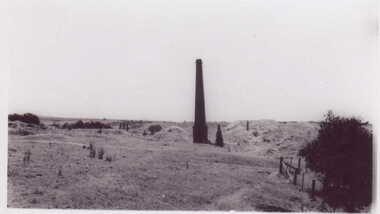
Photograph
SMALL BLACK AND WHITE PHOTOGRAPH OF MINE CHIMNEY PORT PHILIP MINEREVERSE SIDE MINE CHIMNEY JUST WEST OF SANDHEAPS FROM TALBOT ROAD LOOKING NORTH TO CHIMNEY OF PORT PHILIP MINElocal history, photography, photographs -
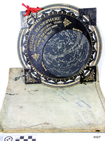 Flagstaff Hill Maritime Museum and Village
Planisphere, Early 20th Century
The word Planisphere (Latin planisphaerium) was originally used in the second century by Claudius Ptolemy to describe the representation of a spherical Earth by a map drawn in the plane. This usage continued into the Renaissance: for example Gerardus Mercator described his 1569 world map as a Planisphere. The word describes the representation of the star-filled celestial sphere on the plane. The first star chart to have the name "Planisphere" was made in 1624 by Jacob Bartsch. Bartsch was the son-in-law of Johannes Kepler, discoverer of Kepler's laws of planetary motion. A significant item of celestial mapping used by marine navigators This particular item was made and used in the first quarter to half of the 20th centuryPlanisphere of northern hemisphere, with canvas bag. Planisphere consists of a circular star chart attached at its centre to an opaque circular overlay that has a clear elliptical window or hole so that only a portion of the sky map will be visible in the window or hole area at any given time. The chart and overlay are mounted so that they are free to rotate about a common pivot point at their centres. The star chart contains the brightest stars, constellations and (possibly) deep-sky objects visible from a particular latitude on Earth. The night sky that one sees from the Earth depends on whether the observer is in the northern or southern hemispheres and the latitude. A Planisphere window is designed for a particular latitude and will be accurate enough for a certain band either side of that. Planisphere makers will usually offer them in a number of versions for different latitudes. Planispheres only show the stars visible from the observer's latitude; stars below the horizon are not included. A complete twenty-four-hour time cycle is marked on the rim of the overlay. A full twelve months of calendar dates are marked on the rim of the starchart. The window is marked to show the direction of the eastern and western horizons. The disc and overlay are adjusted so that the observer's local time of day on the overlay corresponds to that day's date on the star chart disc. The portion of the star chart visible in the window then represents (with a distortion because it is a flat surface representing a spherical volume) the distribution of stars in the sky at that moment for the Planispheres designed location. Users hold the Planisphere above their head with the eastern and western horizons correctly aligned to match the chart to actual star positions. "Made in Germany for GEORGE PHILIP & SONS Ltd. Geographical and Educational Depot, 32 Fleet Street, London" Canvas bag has "Capt. H (Howard) Tyler from Captain H. F. Woolf" "Tyler 22 ? St East Brighton" also "13 Halls St Flinders"flagstaff hill, warrnambool, shipwrecked-coast, flagstaff-hill, flagstaff-hill-maritime-museum, maritime-museum, shipwreck-coast, flagstaff-hill-maritime-village, planisphere, star map, marine navigation, maps, george philip & sons -
 RMIT Design Archives
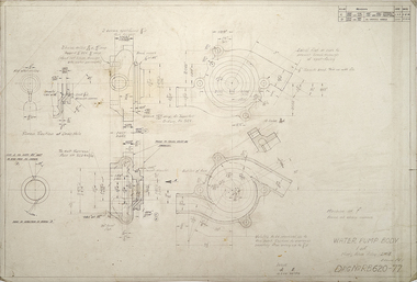
Drawings, Water Pump Body, RB620-77
Designed for Repcopencil, acetate -
Thompson's Foundry Band Inc. (Castlemaine)
Sheet Music, Almost Persuaded to Believe
For Brass Band -
 Clunes Museum
Photograph
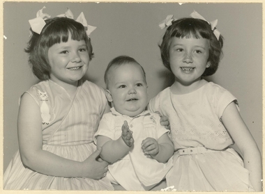
BLACK AND WHITE PHOTOGRAPH, ALISON, ADELE & PHILIP CLARKE CHILDREN OF ALEX AND FLORENCE CLARKE CIRCA 1963BLACK AND WHITE PHOTOGRAPH THREE CLARK CHILDREN; ALISON, ADELE AND PHILIP CIRCA 1963CD & RA RADFORD PHONE 278075local history, photography, photographs, hudson - laura -
Whitehorse Historical Society Inc.
Letter - Correspondence, Unlicensed charcoal burners at Nunawading, 1864
Letter to Superintendent of Police from Mounted Constable Philip Purcell, November 1864 about unlicensed charcoal burners on crown land.Letter to Superintendent of Police from Mounted Constable Philip Purcell, November 1864 about unlicensed charcoal burners on crown land.Letter to Superintendent of Police from Mounted Constable Philip Purcell, November 1864 about unlicensed charcoal burners on crown land.charcoal burning, bourke district - nunawading, purcell, philip -
Whitehorse Historical Society Inc.
Article, Visitor Centre Upgrade, 2016
Mayor Philip Daw opened the new Blackburn Lake Sanctuary Visitor Centre on April 30th 2016.Mayor Philip Daw opened the new Blackburn Lake Sanctuary Visitor Centre on April 30th 2016.Mayor Philip Daw opened the new Blackburn Lake Sanctuary Visitor Centre on April 30th 2016.blackburn lake information centre, blackburn, daw, philip, blackburn lake sanctuary -
 Whitehorse Historical Society Inc.
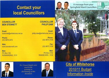
Document, Message from your Springfield Ward Councillors, 2010
Brochure about City of Whitehorse's 2010/11 budget by Crs. Ben Stennet and Philip Daw of Springfield Ward.Brochure about City of Whitehorse's 2010/11 budget by Crs. Ben Stennet and Philip Daw of Springfield Ward.Brochure about City of Whitehorse's 2010/11 budget by Crs. Ben Stennet and Philip Daw of Springfield Ward.daw, philip, city of whitehorse, stennett, ben -
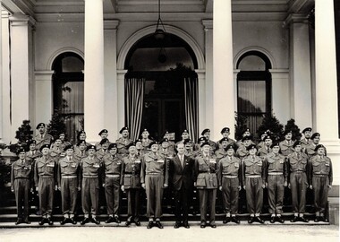 8th/13th Victorian Mounted Rifles Regimental Collection
Photograph - Officers meeting Prince Philip 1954
Black and white photograph of officers of 2nd Armoured Brigade at Government House Melbourne with HRH Prince Philip, March 1954.military, philip, 2nd armoured brigade, melbourne, royal visit -
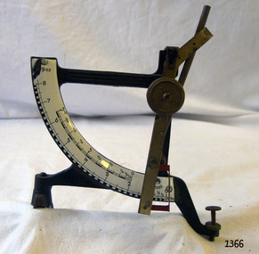 Flagstaff Hill Maritime Museum and Village
Instrument - Letter Scale, Philip Jakob, Maul, 1930s
Jakob Maul (1866-1953) founded a metal works factory in 1912 at Zell in Odenwald not far from Frankfurt. He was born the son of a winegrower from the Rheinhessen region of Germany that lies on the left bank of the river Rhine. At the age of 45, he started a metal works factory to produce various types of scales but during the second world war the factory was bombed and production ended. Production for the manufacture of scales resumed in 1948. In 1953 at his death Jakobs son Fritz Scharmann an engineer who had been working with his father since 1923 took over the management of the Maul companies. In 1970 the production responsibilities for Philip J Maul was taken over by Porti Office Equipment who was based in Hamburg. The company has undergone several integrations with subsidiary companies. Today the company has diversified into different areas one of which is manufacturing solar scales. An original postal scale made in Germany before the Second World War and regarded today as a collector's item. It is significant as it is a snapshot into the past and how everyday vintage items were used and interacted within society in the 1930s.Antique German Jacob Maul "Concav" brass postal or letter scale, quadrant type, with pendulum, measuring up to 9ozs. The scale has a level-adjusting screw.The balance is marked "CONCAV" and graduated in imperial ounces to 9 ozflagstaff hill, warrnambool, shipwrecked-coast, flagstaff-hill, flagstaff-hill-maritime-museum, maritime-museum, shipwreck-coast, flagstaff-hill-maritime-village, scale, quadrant scale, postal weight, 9 oz, philip jakob, maul, scale manufacturer, german industry, weighing instrument, inclination scale -
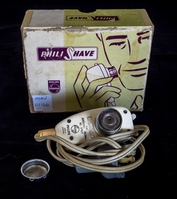 City of Moorabbin Historical Society (Operating the Box Cottage Museum)
Personal Effects electric shaver 'Philishave' c1950, c1950
The Philips Company was founded in 1891, by Gerard Philips and his father Frederik Philips in Holland (Netherlands) and started the production of carbon-filament lamps and other electro-technical products in 1892. The first Philips shaver was introduced in the 1930s, and was simply called Philishave. The Philishave has remained part of the Philips product . In 2018, the independent Philips Lighting N.V. was renamed Signify N.V. However, it continues to produce and market Philips-branded products such as LED light bulbs After World War 11 1939-45, new estates were opened for housing returned soldiers in City of Moorabbin and most of the men began using the new convenient electric razors manufactured by Philips and Gillette.An electric shaver 'Philishave' c 1950 with box, shaver head protector, electrical cord and plug Box ; PHILI SHAVE / PHILIPS Trademark Shaver :PHIL / SHAVE / AW / 209230V 4030 / AC ONLY / RTM / PHILLIPS / MADE IN / AUSTRALIApersonal effects, razors, electric shavers, philips pty ltd,, early settlers, city of moorabbin, post world war 11 settlement, bentleigh, highett, cheltenham, ormond, reed george, clark judy -
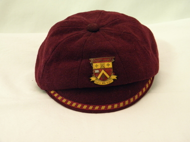 Galen Catholic College
Cap school uniform, Philip Joseph & Son, Melbourne were the makers. Callenders Pty Ltd, Wangaratta were the local suppliers, 1955 to mid 1970s
Champagnat College Wangaratta was opened in 1955 by the Marist Brothers. The sheaf of wheat on the badge represents the agricultural nature of the region. The southern cross represents Australia, the open book represents learning and the Jerusalem crosses represent the Catholic / Christian heritage of the college. The Marist 'M' represents the values and beliefs of the Marist Brothers, especially their devotion to Mary, the Mother of God. Maroon woolen boy's cap with gold and maroon braid trim on the peak. Cap is sewn in eight segments with cloth covered button at peak. Black cotton lining with circle of cream cotton in the centre where details of maker and owner are recorded. A yellow and maroon metal badge with gold detail is sewn to the front of the cap at four points. The words CHAMPAGNAT and DIEU ME VOIT are on the badge. Metal badge has Champagnat, the name of the college. Dieu Me Voit was the college motto. There is a sheaf of wheat, an open book, Marist Insignia 'M' and two Jerusalem crosses are also on the badge. Inside the makers were Philip Joseph and Son, Melbourne. It was made for Callenders Pty Ltd Wangaratta. Size is 6 5/8. Two owner's names: Original owner M.J. Monga or Mongu and Mongan has been written above this. Cap has information 'Improved fitting',' Pure wool,' 'Guaranteed Quality' and 'Genuine Flexite Peak.' -
Linton Mechanics Institute and Free Library Collection
Book - Novel, Gibbs, Philip (Philip Armand Hamilton Gibbs), The age of reason, [n.d.] [1928?]
288 p. : section of original dust jacket pasted to front cover, with image of a man engrossed by scientific instruments while a woman dances in the background.fictionfiction, philip gibbs -
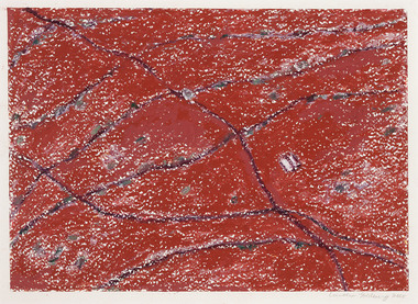 Footscray Community Arts
Corner Store, Carolyn Goldberg, (exact); 2005
MEDIUM: Oil pastel on paper DESCRIPTION: Red oil and pastel painting Cream outer frame with glass front Image and white board inner frame under glassSigned and dated; bottom proper left corner Signed and dated on backing board - geographical referencecorner, store, goldberg, pastel -
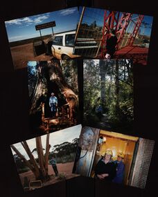
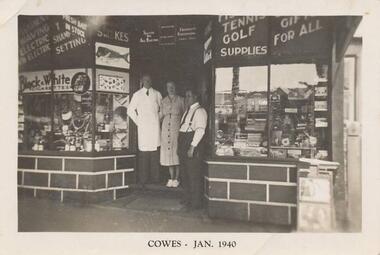 Phillip Island and District Historical Society Inc.
Photograph, 1940
Nine photographs from a collection of 33 donated by Leonie Brennan. Photographs belonged to Edward (Ted) Sands, hairdresser.Photograph 215-01 Black & White photograph of 3 people standing in front of Mr Anderson's shop in Cowes. Miss D Winson?? Mr O S Kennedy & Mr R Anderson. Photograph 215-02 Black & White photograph of landing cranes on the Cowes pier. Cowes foreshore and mature trees in background. Photograph 215-03 Black & White photograph of the early construction of Phillip Island bridge viewed from Phillip Island. Shows the base structure of the first bridge. Photograph 215-04 Black & White photograph of the Newhaven - San Remo Punt on the shore on the Phillip Island side. Photograph 215-05 Black & White photograph of Edward (Ted) Sands standing in front of R Anderson's shop in Cowes. Photograph 215-06 Black & White photograph of a koala in tree in front of shed and water tanks. Photograph 215-07 Black & White photograph of the Isle of Wight Hotel showing front footpath and shop next door. Photograph 215-08 Black & White Photograph of the Cowes beach at low tide, showing mature trees on the foreshore and boats in the water. Photograph 215-09 Black & White Photograph of Mr R Anderson's Shop in Cowes.All photographs except for one marked on front with "Cowes" the month and year 1940.cowes shop phillip island, mr anderson, mr o s kennedy, mr edward (ted) sands, isle of wight hotel phillip island, cowes pier phillip island, cowes beach phillip island, newhaven-san remo punt, wildlife - koala, koala cowes phillip island, phillip island first bridge, leonie brennan -
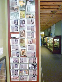 National Vietnam Veterans Museum (NVVM)
Poster - Poster, Information Board, 9th Battalion
One small and one large maroon coloured board with lettering in yellow. Small one has embedded name of 9th Battalion- Roll of honour. Large one has 35silver frames with Photograph of those who sacrified. On the bottom of the board is the Roman number IX with a RAM's head in the centre.Royal Australian Regiment - Duty first (All 35 photos have names, rank, company, date of passing and a short history of their lives, one silver frame is missing)honour roll, 9 rar -
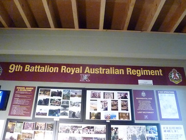 National Vietnam Veterans Museum (NVVM)
Poster - Poster, Information Board, 9th Battalion Roll of Honour
Maroon colourded board with two square boards with Regiment emblem on it, attached to beginning and end of main board. Main board displays Battalion/Regiment name and the number "9" in Roman numerals with RAMs head in centre. Lettering Yellow9th Battalion Royal Australian Regiment. On Ensignia - Duty First9th battalion, honour roll