Showing 1571 items
matching prior street
-
 Orbost & District Historical Society
black and white photograph, early 20th century
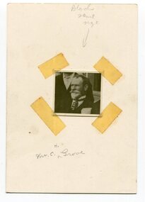
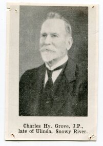
This is a photograph of Councillor Charles Henry Grove who represented South Riding on the Orbost Shire Council. from 1893 - 1901. He was president in 1893-1894, 1895-1896 and 1900-1901. He also served on the Tambo Shire prior to the formation of the Croajingolong / Orbost Shire. Charles Henry [Carl] Grove died on 17/4/1938 at Box Hill at the age of 88 and was buried in Orbost. Prior to coming to the Snowy River district, Carl worked as overseer on Buchan Station. In 1880, he selected land at Newmerella after first coming here in 1874 with early selector James A Robertson. He married Annie Robertson in 1876. Carl was a farmer, hop and seed grower and nurseryman. He was an elected Councillor of the newly formed Tambo Shire in 1882, and then in 1892 to the Orbost Shire where he served for many years filling various public roles. In 1911, he shifted to Queensland, but later returned to Victoria and died at Box Hill. (info. Newsletter 113Carl Grove was a prominent early Orbost citizen.A small square head and shoulders photograph of a man. It is attached to a white card with tape.on front - "Mr C. Grove"grove-charles -
 Orbost & District Historical Society
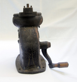
pump, late 19th -early 20th century
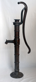
Hand operated water pumps were used to supply water prior to the widespread use of windmill pumps, electric pumps and city water systems. Usually an old pump was made from cast iron, wood or tin. Pumps were very important to people up through the 19th century as farm houses seldom had indoor plumbing with running water. These pumps were also used for outdoor irrigation or laundry purposes.Hand operated water pumps were important before indoor plumbing was adequate. An iron water pump - hand-operated by a lever to the side. A plunger moves up and down (missing). It has a spout and has been painted brown.pump-water irrigation rural -
 Orbost & District Historical Society
metal letters, Before 1969
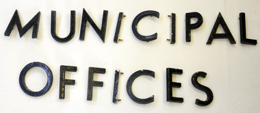
These letters are from the Shire Office prior to its amalgamation to East Gippsland. They were located directly above the front doors at the front entrance to the building. The Shire coat of arms was on the wall on the right of the front entrance to the building directly above the front doors. The current building was opened on Friday 28th February 1969 by the Premier of Victoria, The Hon. Sir Henry E. Bolte, K.C.M.G., M.P. Originally, Orbost was part of the Bairnsdale Road District which was created on 30 April 1867. Splitting away as part of the Shire of Tambo in 1882, Orbost was first incorporated as a shire in its own right as the Shire of Croajingolong on 30 May 1892. It received its present name on 17 February 1893. On 3 January 1913 part of its western riding was annexed to Tambo as its Cunninghame Riding. On 2 December 1994, the Shire was abolished, and merged with City and Shire of Bairnsdale, Shire of Tambo, most of Shire of Omeo and the Boole Boole Peninsula from Shire of Rosedale into the Shire of East Gippsland. Sixteen metal letters - M U N I C I P A L O F F I C E S They are probably painted aluminium.municipal orbost-shire-council government -
 Orbost & District Historical Society
nurse's cap, before late 1960's
This cap would have been worn by a student nurse in her third year of training as in the first year her cap had no arrows. Prior to the transfer of nursing education to the university sector, nurses were trained in a course of instruction in hospital nursing schools that awarded a certificate in general nursing. These courses were generally for a three-year period, and nurses were paid employees of the parent hospital. In Melbourne after WW11 because individual hospitals couldn't get enough nursing students a school of nursing was established - The Royal Melbourne and Associated Hospitals School of Nursing.A white cotton cap which draws up at the back with string to form a frill. It was pinned on the hair. The cap has two red arrows on the rim.H.D. MURRELL 5485health nursing uniform -
 Orbost & District Historical Society
aerial photograph, 1970's
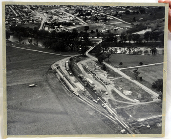
This photograph was taken prior to the closure of the Orbost -Bairnsdale freight line in 1987.The Orbost-Bairnsdale railway initially played a crucial role in developing agricultural industries in Gippsland as well as tourism. It opened in 1916 and operated until 1987, principally carrying timber and farming produce. In the early days of the railway's operation dedicated passenger trains ran but these ceased by the 1930s. The line was completely closed to freightage in 1987.The track infrastructure was dismantled in 1994 and has been redeveloped as the East Gippsland Rail Trail.A large black and white aerial photograph of Orbost Railway Station in the foreground and the Orbost township in the background. It has been pasted onto a piece of Masonite. railway photography orbost, railway photography orbost -
 Orbost & District Historical Society
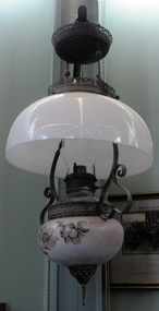
lamp, c. 1892
A large lamp used used to light a room by showing light from above. Used in the Orbost district late 19th to early 20th century prior to electricity connection. Generally, lamps like this had a matching decorations on the shade and vase. It would have been almost impossible to find an exact match if the shade was broken so the next best thing was to replace it with a plain white one. The majority of the removable slip fonts were made to the same dimensions so it was not uncommon for an original font to be replaced with a different brand if it became unusable. This is an example of a domestic lighting device in use before the widespread connection of electricity to houses in Orbost.A large lamp which hangs from a bracket. It has a large white glass cover above the wick burner and below is a white bowl decorated with flowers. The hanging lamp is American and, from the design and pattern of the brass work, it was made by Edward Miller & Co. Both the shade and vase (font holder) are glass. It is most likely that the shade has been replaced at some stage. (ref. oillampantiques.com) illumination-lamp hanging-lamp kerosene-lamp -
 Orbost & District Historical Society
cream separator, 1920s - 1950s
This item would have been very common on farms throughout the Orbost area. Prior to bulk milk, cream was the major commodity which was sold to the butter factory. This is a small separator, typical of home use. This domestic kitchen appliance is typical of the period when food processing was done at home. It would have been before the time of mass food processing factoriesHand operated rusted metal cream separator with metal and wood handle.Front - A.O Handle-75.T.PR.MIN Back- (RHS) A.O. (LHS) Co-op in outline of Australia.cream-separator domestic-food-preparation dairy-farming -
 Orbost & District Historical Society
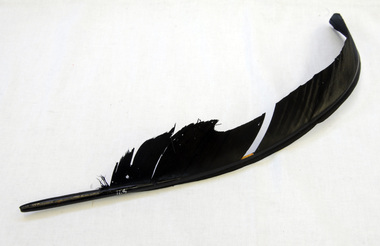
feather quill pen, 19th Century
Used for writing with ink prior to metal nibs and fountain pens.A black feather with hollowed out end for a nib or to be shaped for writing with ink.feather quill writing -
 Orbost & District Historical Society
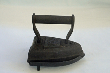
iron, 19th Century
Used in the Orbost district prior to electicity being connected. Was heated on the top of a wood-fired stove. This is an example of a common domestic appliance used before electricity was widely connected to households.A small triangular shaped cast iron clothes iron on a metal stand. The stand has small legs and holes in its base. The iron has a Salter brand.A symbol on the top of the iron in the shape of a bow.iron clothes-iron household-item -
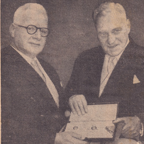 The Beechworth Burke Museum
Newspaper - Photograph, c.1950
Taken in the 1950s, this picture is of two veterans of the First World War, Colonel Sir William Leggatt and Brigadier Sir Lionel Harris who fought together in France over 30 years prior. The two men were invested by the Queen at Buckingham palace as Knights, a prestigious honour for Australian soldiers, who for another 20 years would have no official recognition by the Australian government through the 'Order of Australia.' This image showcases the role of Australian service members who fought during the first world war being honoured by the British Government, personally meeting the Queen. Black and white photograph accompanied by text below taken from a NewspaperObverse: VICTORIA'S Agent-General, Colonel Sir William Leggatt (right) and his old / cobber's Brigadier Sir Lionel Harris, outside Buckingham Palace yesterday after hav- / ing received the accolade form the Queen. Thirty-two years ago as sergeant and private / they shared a trench in France. Yesterday as they waited to be knighted by the / Queen, Sir William said, "if anyone had told us then that we were ever going to / meet like this, we would have thought he was off his block. - Today's radiophoto / Reverse: 6539 (in pencil) / burke museum, beechworth, beechworth museum, world war one, military album, trenches, nighted, queen, buckingham palace, wwi, sir william leggatt, sir lionel harris -
 The Beechworth Burke Museum
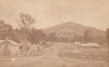
Photograph - Carte de Visite
In July of 1880, Ann Jones' successful hotel in Glenrowan burnt to the ground during the Kelly siege. She had opened her business in the year prior having been unsuccessful in her attempt to run a tea-room business in Wangaratta. The first building on this particular site was the home Ann Jones had built for herself and her family. Two years later she converted the home and added the hotel to the rear of the structure. One year later it was burnt to the ground. This image depicts the streetscape of Glenrowan in 1883, three years after the siege. Importantly, it reveals the appearance of several buildings which can reveal information for how Glenrowan (as a small town) might have stood during the siege. These buildings are of typical Australian colonial "miner's cottage" style. On what would have been the site of Ann Jones' hotel, to the far left of the photograph, a police station stands. This police station was built before April 1883. This image was captured by an unknown photographer. This Carte-de-viste (CdV) previously belonged to the donor's grandfather, Daniel Mullins who was a Police Officer stationed at Glenrowan soon after the Kelly gang siege. Today, the siege has become an important part of Australian culture and Ned Kelly and the Kelly Gang (comprising of Ned Kelly, Dan Kelly, Steve Hart and Joe Byrne) has become ingrained in Australian history and mythology. A CdV is a sepia toned photograph mounted on card and is generally of a small size. This particular style was first patented by Andre Adolphe Eugene Disdéri (1819-1889) in 1854. In 1857, the CdV was introduced to England and after photographs of Queen Victoria, Prince Albert and their family were taken using CdV in 1860 the popularity of this method reached a peak.This photograph is part of the Burke Museum "Kelly album" which includes a significant collection of photographs and artefacts connected to Ned Kelly and the Kelly Gang. Ned Kelly and his gang have become ingrained in Australian popular culture and thus many museums, art galleries and private collections house material connected to the Kelly story which allows the events and people to be researched and interpreted. Artefacts and photographs pertaining to the Kelly gang are particularly valuable for Australian museums. This particular photograph is significant for its connection to the Glenrowan Siege and Ann Jones' Hotel which burnt down during the siege in June 1880. Taken in 1883, this photograph (taken by an unidentified photographer) has the opportunity to provide information about the townscape of Glenrowan shortly after the siege. It also provides important insight into the architecture and layout of the town. To the far right of the image, the photograph depicts the police station which was built on the site of Ann Jones' Hotel which can provide important information for the Kelly story and how the town evolved following 1880. It is also interesting to emphasise that the police station was built on the site of Ned Kelly and the Kelly gang's last stand.This photograph is a sepia image of the Glenrowan streetscape depicting several buildings. The newly built police station (in 1883) stands on the far right of the image on the site of the former Ann Jones Hotel. On the left are several buildings built in typical 'miner's cottage' Australian colonial style. This includes the gable roof with the skillion at rear. An unidentifiable individual stands next to the chimney of the front left building. Numerous paddocks appear in the image, particularly in the front right and the rear of the houses contain many trees. To the rear of the image, there is a mountain. A street runs through the centre of the photograph.Glenrowan / taken 1.4.83 ... / BMM 8086kelly album, ned kelly, glenrowan, police history, police, australian architecture, streetscape, glenrowan 1883, 1883, dan kelly, steve hart, joe byrne, carte-de-viste, james bray, daniel mullins, william e barnes, colonial australia, police station, photograph -
 The Beechworth Burke Museum
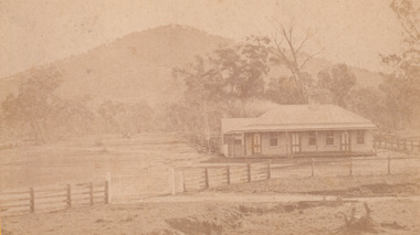
Photograph - Carte de Visite, William E Barnes
In July of 1880, Ann Jones' successful hotel in Glenrowan burnt to the ground during the Kelly siege. She had opened her business in the year prior having been unsuccessful in her attempt to run a tea-room business in Wangaratta. The first building on this particular site was the home Ann Jones had built for herself and her family. Two years later she converted the home and added the hotel to the rear of the structure. One year later it was burnt to the ground. This image depicts the streetscape of Glenrowan in 1883, three years after the siege. Importantly, it reveals the appearance of several buildings which can reveal information for how Glenrowan (as a small town) might have stood during the siege. These buildings are of typical Australian colonial "miner's cottage" style. On what would have been the site of Ann Jones' hotel, to the far left of the photograph, a police station stands. This police station was built before April 1883. This Carte-de-viste (CdV) taken by renowned Wangaratta based photographer William Edward Barnes previously belonged to the donor's grandfather, Daniel Mullins who was a Police Officer stationed at Glenrowan soon after the Kelly gang siege. Today, the siege has become an important part of Australian culture and Ned Kelly and the Kelly Gang (comprising of Ned Kelly, Dan Kelly, Steve Hart and Joe Byrne) has become ingrained in Australian history and mythology. A CdV is a sepia toned photograph mounted on card and is generally of a small size. This particular style was first patented by Andre Adolphe Eugene Disdéri (1819-1889) in 1854. In 1857, the CdV was introduced to England and after photographs of Queen Victoria, Prince Albert and their family were taken using CdV in 1860 the popularity of this method reached a peak.This photograph is part of the Burke Museum "Kelly album" which includes a significant collection of photographs and artefacts connected to Ned Kelly and the Kelly Gang. Ned Kelly and his gang have become ingrained in Australian popular culture and thus many museums, art galleries and private collections house material connected to the Kelly story which allows the events and people to be researched and interpreted. Artefacts and photographs pertaining to the Kelly gang are particularly valuable for Australian museums. This particular photograph is significant for its connection to Wangaratta based photographer William Edward Barnes and to the Glenrowan Siege and Ann Jones' Hotel which burnt down during the siege in June 1880. Taken in 1883, this photograph has the opportunity to provide information about the townscape of Glenrowan shortly after the siege. It also provides important insight into the architecture and layout of the town. To the far right of the image, the photograph depicts the police station which was built on the site of Ann Jones' Hotel which can provide important information for the Kelly story and how the town evolved following 1880. It is also interesting to emphasise that the police station was built on the site of Ned Kelly and the Kelly gang's last stand.This photograph is a sepia image mounted on yellow card which depicts the newly built police station (in 1882) which stands on the far right of the image on the site of the former Ann Jones Hotel. A fence appears through the lower front of the image and an open paddock is to the left. In the rear centre of the image, there is a mountain. In front of the mountain are many trees, most of them gum. The police station is a one storey structure with a veranda and there are three doorways visible in the image. The image depicts four windows on the front of the station.W.E.Barnes / photographer / Wangaratta / ...1882 / BMM8087kelly album, william barnes, wangaratta photographer, carte-de-viste, glenrowan, 1882, police station, ann jones inn, ann jones hotel, kelly siege, glenrowan siege, colonial australia -
 The Beechworth Burke Museum
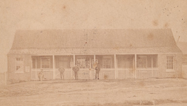
Photograph - Carte de Visite, William E Barnes
In July of 1880, Ann Jones' successful hotel in Glenrowan burnt to the ground during the Kelly siege. She had opened her business in the year prior having been unsuccessful in her attempt to run a tea-room business in Wangaratta. The first building on this particular site was the home Ann Jones had built for herself and her family. Two years later she converted the home and added the hotel to the rear of the structure. One year later it was burnt to the ground. This image depicts the police station in 1882 on what would have been the site of Ann Jones' hotel. This Carte-de-viste (CdV) taken by renowned Wangaratta based photographer William Edward Barnes previously belonged to the donor's grandfather, Daniel Mullins who was a Police Officer stationed at Glenrowan soon after the Kelly gang siege. Today, the siege has become an important part of Australian culture and Ned Kelly and the Kelly Gang (comprising of Ned Kelly, Dan Kelly, Steve Hart and Joe Byrne) has become ingrained in Australian history and mythology. A CdV is a sepia toned photograph mounted on card and is generally of a small size. This particular style was first patented by Andre Adolphe Eugene Disdéri (1819-1889) in 1854. In 1857, the CdV was introduced to England and after photographs of Queen Victoria, Prince Albert and their family were taken using CdV in 1860 the popularity of this method reached a peak.This photograph is part of the Burke Museum "Kelly album" which includes a significant collection of photographs and artefacts connected to Ned Kelly and the Kelly Gang. Ned Kelly and his gang have become ingrained in Australian popular culture and thus many museums, art galleries and private collections house material connected to the Kelly story which allows the events and people to be researched and interpreted. Artefacts and photographs pertaining to the Kelly gang are particularly valuable for Australian museums. This particular photograph is significant for its connection to Wangaratta based photographer William Edward Barnes and to the Glenrowan Siege and Ann Jones' Hotel which burnt down during the siege in June 1880. Taken in 1882, this photograph has the opportunity to provide information about the townscape of Glenrowan shortly after the siege. It also provides important insight into the architecture and layout of the town. To the far right of the image, the photograph depicts the police station which was built on the site of Ann Jones' Hotel which can provide important information for the Kelly story and how the town evolved following 1880. It is also interesting to emphasise that the police station was built on the site of Ned Kelly and the Kelly gang's last stand.Sepia coloured photograph with a faded appearance. Image depicts four policemen with three standing and one sitting on a chair outside the Glenrowan police station. The station takes up the majority of the image and is placed in the centre of the photo. The four men are positioned on the left side of the station. The station is a large building with a gabled roof and extensions built into the veranda on either side. In between these extensions, the property has a white picket fence which runs from the extensions directly beneath the veranda enclosing the front of the structure. The letters 1, 2, 3, 4 are written on the yellow paper on which the image is situated and relate to the images in the photo. The reverse of the photo provides the names of each policeman and reveals the image as being from the collection of William E Barnes a Wangaratta based photographer.Obverse: 1. 2. 3. 4. Reverse: No. 1. is Mullins, D. G. / 2. Lord, Edward. / 3. Millar, Allex. / 4. Hedberg, O. G. / All Comrades / Glenrowan Police Station / 1 August 1882 / W. E. Barnes / Photographer / Wangaratta /kelly album, william barnes, wangaratta photographer, carte-de-viste, glenrowan, 1882, police station, ann jones inn, ann jones hotel, kelly siege, glenrowan siege, colonial australia, ned kelly, steve hart, joe byrne, william e barnes -
 The Beechworth Burke Museum
Postcard
This Australian yesteryear postcard was published by Cobb & Co in circa 1990. It is a sepia toned artwork of the Ann Jones Inn in Glenrowan which was taken prior to 1880. The building at rear in this photograph was the private residence of Ann Jones, a migrant from Tipperary, Ireland. Two years after building her private residence, in 1878/1879, Ann Jones added the Inn to the front of the building which is depicted in the postcard. In 1880 the Inn was burned to the ground during the Kelly Gang siege. After the siege, Ann Jones and her children continued to live on the same location in a makeshift hut. This hut was later replaced with a dwelling using compensation money provided to Ann from the government for the loss of her property and goods; however, she was denied a new trading licence which did not enable her to re-establish her previously successful business. The reverse of this postcard provides a snippet of information into the Glenrowan siege, for which this site is most well-known. It outlines the role and demise of the members of the Kelly Gang but what it does not include is how Ann Jones, owner of the Inn depicted on the postcard, was impacted. Ann’s son of 13 years, Johnny was killed during the siege, and a bullet grazed the forehead of her daughter, Jane Jones. Jane would die two years after this event from tuberculosis, but it was believed by Ann that the cause was grief for the death of her brother and distress at having witnessed the siege. Ann was provided with 100 pounds in compensation money for the loss of her children. Her husband, Owen Jones passed away late 1880 and in 1891 Ann Jones remarried. She died at the age of 80 in 1910. The “last stand” of the Kelly Gang at this location is estimated by Dr Stuart Dawson of Monash University to have taken less than 10 minutes in duration. During and following this time, the life of Ann Jones was turned upside down and everything she had worked for in the preceding years was now in ruins. This postcard has the capacity to reveal information about the popularity of the Kelly story in Australia. It was created in approximately the 1990s which perhaps reveals a resurgence in interest into the Kelly Gang and Australian history when card was made. This image, and others depicting the Ann Jone’s Inn, have the ability to shed light on the Kelly story and the events of the Glenrowan Siege. Additionally, they can reveal information into the life of a female business owner during the 1870-1880 period. Archaeological research has been conducted at this site by LaTrobe University and a study of these images alongside the analysis of the material culture found at this location can help to build more comprehensive understanding into life in Australia during this period and Ann Jones herself.Sepia rectangular postcard printed on cardObverse: [Illegible] Reverse: G4/ 3276/ Australian / Yesteryear / cards/ correspondence / address / Published by Cobb & Co (03) 5766 2409 / The Glenrowan Inn owned by Ann Jones. / It was this Inn in which the Kelly Gang imprisoned / 62 people, while waiting for the special train / carrying the police to arrive from Benalla. On 28th / June 1880, following a seige which lasted over 12 / hours, Ned Kelly was captured. Joe Byrne was shot, / and the Inn was set on fire in an attempt to flush out / the two remaining outlaws, Dan Kelly and Steve / Hart. However, some time prior, the two boys, it / was believed, had committed suicide, as a result, / their bodies were incinerated beyond recognition. / A sepia tone facsimile of / an early Australian photograph. /kelly album, postcard, glenrowan inn, kelly siege, australia yesteryear card, cobb & co publisher, ned kelly capture, jones ann, dan kelly, joe byrne, steve hart, fire, train, police, benalla, 28 june 1880 -
 The Beechworth Burke Museum
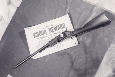
Photograph
In this image a Colt 1855 Revolving Rifle is placed upon a sign detailing an £8,000 reward for robbery and murder. Writing on the rear of the photograph identifies the rifle as having belonged to Joe Byrne. In colonial Victoria, the Colt brand firearm was highly popular. They began their popularity in the goldfields of the early 1850s. Individuals, particularly those coming to Victoria with prior experience in the goldfield, brought with them a means of self-defence because of the prevalence of assault and robbery on the goldfields. In the 1860s, the Colt firearm became popular among the Victorian Police force. It was decided in June 1864 by Chief Commissioner of Police, Frederick Standish that the Colt revolvers were far more practical, being of simpler construction and therefore, more easily cleaned and less dangerous than the revolvers used prior to this: the Adams and Kerr firearms. The Colt revolver remained in use in regional districts of Victoria as late as the early 1880 when they were used at the Kelly siege at Glenrowan. The £8,000 reward was issued in 1879 after the Kelly Gang committed numerous bank robberies at Euroa and Jerilderie. In the year prior, the Kelly Gang murdered three policemen at Stringybark Creek. This resulted in the creation of the “Felon’s Apprehension Act 1878” which enabled an individual, whether a part of the Police force or civilian, to shoot a declared outlaw on sight. After the bank robberies, the Police force of NSW and Victoria increased the existing reward to this £8,000 amount.This photograph is significant for what it can potentially reveal about the Kelly Gang and firearms made in this period. The rifle in the image is a Colt Revolving Rifle which was known to have been used by the Victorian Police force from the early 1850s to the late 1880s. It is also known that the Kelly Gang stole police rifles which they used to practise with and so the identification of the rifle as having belonged to Joe Byrne is of significant importance to researchers studying the firearms of the Kelly Gang. More research is needed to solidify the connection of this particular weapon to Byrne other than the handwritten note on the back of the photograph. The Burke Museum Beechworth is home to a significant collection of photographs connected to Ned Kelly and the Kelly Gang. Photographs like this one are valuable for what they can potentially reveal about the Kelly Gang and the Police force during this period. Alongside the study of the other images, photographs from this collection have the ability to further expand current knowledge on this period of Australian history. There is also the capability to provide an analysis of how these firearms and Kelly memorabilia have been received in the past. It could be beneficial to undertake a close study of the use history and reception of these artefacts within the museum context.Black and white rectangular reproduced photograph printed on matte photographic paperReverse: 10268 / Joe Byrne's / Riflekelly album, ned kelly, kelly gang, joe byrne, rewards, outlaw, criminals, bushrangers, colt, police, firearm, beechworth, reward, felon's apprehension act 1878, 1880, glenrowan, colt revolver, revolving rifle, 8000 pound reward, jerilderie, euroa, beechworth goldfield -
 The Beechworth Burke Museum
Photograph
This photograph is of Robert O'Hara Burke (6 May 1821 – c. 28 June 1861) who was an Irish soldier and police officer who achieved fame as an Australian explorer. He was the leader of the ill-fated Burke and Wills expedition, which was the first expedition to cross Australia from south to north, finding a route across the continent from the settled areas of Victoria to the Gulf of Carpentaria. Prior to leading this expedition, Burke was the superintendent of Police in Beechworth from 1858-1860. The Robert O’Hara Burke Memorial Museum was named in honour of Robert O’Hara Burke after his death at Coopers Creek in 1861 during expedition. This particular image of Robert O'Hara Burke features on the 'Pioneer Board' which is currently on display in the Museum. Black and white rectangular copy of a photograph. Image is printed on gloss photographic paper and has a white unprinted boarder. Reverse: 34 / Photo credit: Burke Museum / BEECHWORTH / 46% /robert o'hara burke, pioneers of beechworth, pioneer board, beechworth, police superintendent -
 Flagstaff Hill Maritime Museum and Village
Photograph, early 1900's
This photograph of the 10 crew of the SPECULANT would have been taken prior to Feb 10th 1911, when the ship was wrecked on the south coast of Victoria at a place called Cape Patton. The barquentine SPECULANT was a steel, three-masted sailing ship built in 1895 in Inverkeithing, Scotland, registered in Warrnambool, Victoria and wrecked at Cape Paton, Victoria, 10th February 1911. The SPECULANT had been involved in the timber trade between the United Kingdom and Russia, until sold to its Warrnambool owners and timber merchants Messrs. P.J. McGennan & Co. (Peter John McGennan) in 1902 for 3000 pounds and had her sailed to Warrnambool as her new port. Peter John McGennan was born in 1844 and worked as a builder and cooper in Holyhead, Anglesea, Wales. He immigrated to Australia in 1869 as a free settler and arrived in Warrnambool in 1871 and undertook management of a property in Grassmere for Mr. Palmer. Peter met his wife Emily in South Melbourne and they married in 1873. They had ten children including Harry who lived to 1965, and Andrew who lived until 1958. (The other children were their four brothers - John who was killed in the Dardenalles aged 35, Frederick who died aged 8, Peter who died aged 28, Frank who died aged 5 weeks - and four sisters - Beatrice who died age 89, Edith who died aged 49, Blanche who died aged 89 and Eveline who died aged 48.) In 1874 Peter starting a boating establishment on the Hopkins River. In 1875 he opened up a Coopers business in Kepler Street next to what was Bateman, Smith and Co., moving to Liebig Street, next to the Victoria Hotel, in 1877. In 1882 he then moved to Lava Street (which in later years was the site of Chandlers Hardware Store). He was associated with the establishment of the Butter Factory at Allansford. He started making Butter Boxes to his own design and cheese batts for the Butter Factory. In 1896 established a Box Factory in Davis Street Merrivale, employing 24 people at its peak, (it was burnt down in 1923); and in Pertobe Road from 1912 (now the Army Barracks building). Peter was a Borough Councillor for Albert Ward from 1885 to 1891, he commenced the Foreshore Trust (including the camping grounds along Pertobe Road), and he was an inaugural Director of the Woollen Mill in Harris Street, buying an extensive share-holding in 1908 from the share trader Edward Vidler. They lobbied the Town Hall to have a formal ‘Cutting’ for the waters of the Merri River to be redirected from its natural opening south of Dennington, to its existing opening near Viaduct Road, in order to have the scourings from the wool at the Woollen Mill discharged into the sea. He sold Butter Boxes around the state, and had to ship them to Melbourne by rail. Peter’s purchase of the SPECULANT in 1902 enabled him to back-load white pine from Kaipara, New Zealand to Warrnambool to make his butter boxes then, to gain profitability, buy and ship potatoes and other primary produce bound to Melbourne. (McGennan & Co. had also owned the LA BELLA, which had traded in timber as well, until she was tragically wrecked with the loss of seven lives, after missing the entrance channel to Warrnambool harbour in 1905. It appears that the SPECULANT was bought to replace the LA BELLA.) In 1911 the SPECULANT had been attempting to depart Warrnambool for almost the entire month of January to undergo docking and overhaul in Melbourne. A month of east and south-easterly winds had forced her to remain sheltered in Lady Bay, Warrnambool apart from one morning of northerlies, when an attempt was made to round Cape Otway; she had to return to shelter in Portland after failing to make any headway. With only 140 tons of sand ballast aboard, the ship would not have been easy to handle. Captain Jacobsen and his crew of nine, mainly Swedes, decided to make for Melbourne, leaving Portland Harbour on 5th February 1911. By the 9th they had reached Cape Otway, where they encountered a moonless night, constant heavy rain, and a heavy sea with a south-easterly wind blowing. After safely rounding Cape Otway the course was changed to east, then north-east to take the vessel to a point six miles off Cape Patton, following the orders of Captain Jacobsen, who told the crew to be very careful with the steering, as the wind and sea was running to leeward. The patent log (used to measure speed) had been out of order for the last four months as no-one in Warrnambool was able to fix it: it was intended to have it repaired in Melbourne. In the meantime the crew measured the vessel's speed by looking over the side and estimating wind strength. This compounded the difficulties of imprecise positioning, as the strong cross wind and sea were acting on the lightly laden vessel to steadily drive it towards the shore. At 3.30am on Friday 10 February 1911 Captain Jacobsen and the first mate were looking over the side of the vessel when they heard the sound of breakers and suddenly struck the rocks. The crew immediately knew they had no chance of getting the SPECULANT off, and attempted to rescue themselves by launching the lifeboat, which was instantly smashed to pieces. One of the crew then volunteered to take a line ashore, and the rest of the crew were all able to drag themselves to shore, some suffering hand lacerations from the rocks. Once ashore they began to walk along the coast towards Lorne, believing it was the nearest settlement. Realising their mistake as dawn broke they returned westwards to Cape Patton, and found a farm belonging to Mr C. Ramsden, who took them in and gave them a change of clothes and food. After resting for a day and returning to the wreck to salvage some of their personal possessions, at 10am on Saturday they set out for Apollo Bay, a voyage that took six hours, sometimes wading through flooded creeks up to their necks. The Age described the wreck as "listed to starboard. All the cabin is gutted and the ballast gone. There is a big rock right through the bottom of her, and there is not the slightest hope of getting her off". A Board of Marine inquiry found that Captain Jacobson was guilty of careless navigation by not taking steps to accurately verify the position of the vessel with respect to Cape Otway when the light was visible and by not setting a safe and proper course with respect to the wind and sea. It suspended his certificate for 6 months and ordered him to pay costs. The location of the wreck site was marked for a long time by two anchors on the shoreline, until in 1970 the larger of the two anchors was recovered by the Underwater Explorers' Club and mounted on the foreshore at Apollo Bay. The bell from the wreck was also donated to the Apollo Bay Surf Lifesaving Club but is recorded to have been stolen. Rusting remains of the wreck can still be found on the shoreline on the southern side of, and directly below Cape Patton. Parts of the SPECULANT site have been buried by rubble from construction and maintenance works to the Great Ocean Road, as well as by naturally occurring landslides. Peter J McGennan passed away in 1920. The Gates in the western wall of the Anglican Church in Henna Street/Koroit St are dedicated to him for his time of community work, which is matched with other prominent Warrnambool citizens; Fletcher Jones, John Younger, J.D.E (Tag) Walter, and Edward Vidler. After Peter J McGennan's death Harry, Andrew and Edith continued to operate the family business until July 11th 1923 when the company was wound up. (Andrew lived in Ryot Street Warrnambool, near Lava Street.) Harry McGennan (Peter and Emily’s son) owned the Criterion Hotel in Kepler Street Warrnambool (now demolished). His son Sid and wife Dot lived in 28 Howard Street (corner of Nelson Street) and Sid managed the Criterion until it was decided by the family to sell, and for he remained Manager for the new owners until he retired. Harry commenced the Foreshore Trust in Warrnambool around 1950. The McGennan Carpark in Pertobe Road is named after Harry and there are Memorial-Stone Gates in his memory. (The Gates were once the original entrance to the carpark but are now the exit.). Peter’s great-grandson, also called Andrew, is a Security Officer in Warrnambool. The Patent Log (also called a Taffrail log) from the SPECULANT, mentioned above, and a number of photographs, are now part of the Collection at Flagstaff Hill Maritime Village. The SPECULANT is historically significant as the largest ship to have been registered in Warrnambool, and is believed to have been the largest barquentine to visit Melbourne. It is evidence of the final days of large commercial sailing vessels involved in the Victorian and New Zealand timber trade. The SPECULANT is listed on the Victorian Heritage Register VHR S626Photograph, black and white. of the 10 crew of the SPECULANT on board the ship holding two 'Speculant Warrnambool' lifebuoys. Taken early 1900's flagstaff hill, warrnambool, shipwrecked-coast, flagstaff-hill, flagstaff-hill-maritime-museum, maritime-museum, shipwreck-coast, flagstaff-hill-maritime-village, warrnambool historical photograph, la bella, speculant, cumming and ellis, international timber trade, p. j. mcgennan and co. warrnambool, peter mcgennan, capt. james jacobsen, warrnambool maritime history, h. pengilley apollo bay -
 Mission to Seafarers Victoria
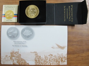
Medal, Service to Australia: 60th anniversary of WWII, 2005
Official issue in 2005 by the Australian Federal Government marking the 60th Anniversary of the ending of World War 2 in 1945. This medal marks Allan Charles Quinn's service in WW2.This Official medal complements the extensive holdings of memorabilia that comprises the Allan Charles Quinn Collection that extensively documents his life,the voyages, and career as a Merchant seaman in the immediate post world war 2 period and prior to the significant changes brought about by container shipping by the end of the 20th Century. Gold-coloured disc medallion in a magnetic black folding display box with plush display mount. Accompanying small brochure on 60th anniversary of WWII in 2005 and an official signed letter from the Australian GovernmentLetter signed by Prime Minister : John Howard and Veterans Affairs Minister De-Anne Kellymedal, gold, world war ii, wwii, world war 2, numismatics, allan charles quinn -
 Mission to Seafarers Victoria
Slide - Glass slide, Black and white, circa 1921
This image provides an additional later modified building view to that of the image of the original single storey building image published on back page of the 1910 MTS Annual Report. According to the Annual Report of 1915 the plans to build a residence on top ( the 2nd storey ) of the Port Melbourne building got the go ahead to commence and opened 1916. Originally designed by architect, Frederick Williams, who built the first brick Mission at Port Melbourne in the 19th C. Walter Butler was commissioned for the second storey.The Port Melbourne building in the image established in the 19th C., still survives. It was a key centre of operations for the Mission prior to the building of the Mission near Australian Wharf in 1907 and prior to the eventual opening of the current "Central Mission" in 1917. NB operations of The Port Melbourne Branch Mission were eventually transferred to the King George V memorial Building, dedicated in December 1937 but demolished in 1995. The Mission depicted here still survives as part of an apartment complex on the corner of Nott st.Positive photograph on medium format glass slide ; b & w image of brick building taken from a corner street level view, with upper storey at one end on glass transparency with a flagpole and flag (Flying Angel) just discernible. The slide is edged with adhesive tape.missions to seamen institute, mission building, frederick williams, walter butler, port melbourne, beach road, mission to seafarers, nott street -
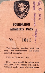 Phillip Island and District Historical Society Inc.
Ephemera - Member's pass, Phillip Island Auto Racing Club Foundation Member's Pass, 1960
Original constructors of the Island racetrack, prior to Lukeys.HistoricalSmall pink coloured cardboard ticket with black printing and PIARC logoPIARC Foundation Member's Pass No.1012 Valid to June 30 1961 R.A. Hunt 28 High Street Mont Albertphillip island car racing, motor car racing, membership ticket -
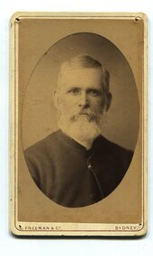 Orbost & District Historical Society
black and white photograph, Freeman & Co, second half 19th century
Mr. Robert Martin - First Church of England was a clergyman stationed at Orbost - 1884-1891. Mr Martin, who was appointed by Bishop Moorhouse of Melbourne, to be Stipendiary Reader in charge of the district in 1885. Prior to that, Mr Martin, a retired sea captain, had unofficially conducted services in all sorts of places, where a congregation could be gathered together, though his business officially was that of a fire insurance argent. (more information in October 2007 Newsletter)This item is associated with churches in Orbost.A black / white portrait photograph, head and shoulders, of a middle - aged man with a white beard.It is an oval shaped photograph set in a cream cardboard mount.on front at bottom - Freeman & Co Sydneymartin-robert church-of-england-orbost church-orbost -
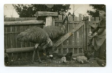 Orbost & District Historical Society
black and white photograph, Segerberg & Bulmer, late 19th century
Charles Henry [Carl] Grove died on 17/4/1938 at Box Hill at the age of 88 and was buried in Orbost. Prior to coming to the Snowy River district, Carl worked as overseer on Buchan Station. In 1880, he selected land at Newmerella after first coming here in 1874 with early selector James A Robertson. He married Annie Robertson in 1876. Carl was a farmer, hop and seed grower and nurseryman. He was an elected Councillor of the newly formed Tambo Shire in 1882, and then in 1892 to the Orbost Shire where he served for many years filling various public roles. In 1911, he shifted to Queensland, but later returned to Victoria and died at Box Hill. (info. Newsletter 113)Two black / white photographs of a woman in a pen feeding two emus and some chickens.grove-annie grove-carl -
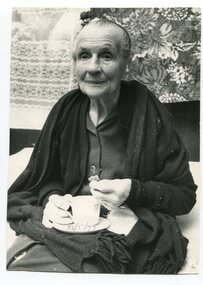 Orbost & District Historical Society
black and white photograph, May 22 1973
This is a photograph of Elizabeth Lawless on her 102nd birthday. The Lawless family lived in Orbost from 1907 - c 1920. John Francis Lawless had a saddlery shop. He died at an early age - 47 years - June 7 1912, leaving his wife, Elizabeth and seven children. The eldest son, Victor Rowland lawless volunteered for service in WW1 but did not leave Australia because of illness. The second son, Edward Vincent Lawless (b 1895 d 1917) worked for McCoy & Co. in Orbost, coachbuilding, undertakers, general blacksmiths and farriers, prior to enlisting in WW!. He was trained as a signaller and was sent to France where he was killed in action on 9.10.1917. Elizabeth Lawless worked as a ladies' nurse (midwife) in Orbost prior to leaving the district in 1920. She lived to 6.6.1975 aged 104 years.The Lawless family was a prominent family in Orbost in the early 20th century.A large black / white photograph of an elderly lady seated and holding a cup of, with biscuit. She has a shawl draped over her shoulders. -
 Orbost & District Historical Society
black and white photograph, late 19th century - early 20th century
This is a photograph of Councillor Charles Henry Grove who represented South Riding on the Orbost Shire Council. from 1893 - 1901. He was president in 1893-1894, 1895-1896 and 1900-1901. He also served on the Tambo Shire prior to the formation of the Croajingolong / Orbost Shire. Charles Henry [Carl] Grove died on 17/4/1938 at Box Hill at the age of 88 and was buried in Orbost. Prior to coming to the Snowy River district, Carl worked as overseer on Buchan Station. In 1880, he selected land at Newmerella after first coming here in 1874 with early selector James A Robertson. He married Annie Robertson in 1876. Carl was a farmer, hop and seed grower and nurseryman. He was an elected Councillor of the newly formed Tambo Shire in 1882, and then in 1892 to the Orbost Shire where he served for many years filling various public roles. In 1911, he shifted to Queensland, but later returned to Victoria and died at Box Hill. (info. Newsletter 113)This item is associated with Carl Grove, a prominent early Orbost citizen.A small black / whitee head and shoulders photograph of a man with beard and moustache, He is wearing a suit and tie.grove-charles -
 Orbost & District Historical Society
black and white photograph, 1884?
James Alexander Robertson was born 14th June, 1855, at Pentridge. the Coburg area which was known as Pentridge at the time, and prior to the building of the gaol. His parents were James Thomson Robertson and Esther (nee Hale), At age 20 James became the first selector on the Snowy River at Lochend. He took up Lots 1, 2 and 3, in the Parish of Newmerella in 1875; with his selection being ratified on May 1st, 1876. The selection included hill and river flat land in the area near where Icy Creek enters the Snowy River. James gradually improved and farmed the property; he cleared and drained Icy Creek and constructed the first known flood-gate on the Snowy River. To meet his farming commitments he supplemented his income by working on the construction and maintenance of roads and drains in the Newmerella area. He gained a contract with the Bairnsdale Shire council to construct the first road cutting down Burn’s Hill at Newmerella. His tender was for £16 ($32), and it took him, with four others, two months to complete the contract. He was single, and, after his untimely death at aged 29, in 1884, his parents and surviving unmarried sisters and brothers moved from Sarsfield to take over his selection at Lochend. (more information Newsletter April 2013)James Robertson was the first selector of land at Lochend, Orbost.A small black / white portrait photograph, oval shaped with a white background. It is of a middle-aged man with a full beard and moustache.on front at bottom - typed in black -:"James Alexander Robertson, Late of Lochend, Snowy River"robertson-james-alexander lochend-robertson -
 Orbost & District Historical Society
black and white photograph, first half 20th century
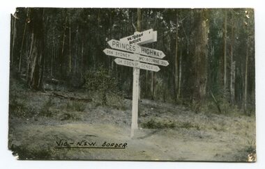
... Orbost & District Historical Society Ruskin Street Orbost ...Prior to the sealing of the Princes Highway west of Orbost, the road surface was anything but good, even by C1917 when cars started to use the road. From Orbost the old road via Marlo to Sydenham was abandoned for the new location which traversed more rugged country via Cabbage Tree, Bell Bird and Club Terrace to Cann River, and the reason for this diversion was on account of settlements being established at Murrungowar and Club Terrace, at which latter place there was a temporary rush to obtain gold. This road was constructed by the Public Works department and a maximum grade of 1 in 19 was adopted, and as speed was not to be catered for the grade followed in and out round the spurs and gullies, resulting in a maze of turns and twists which required a good deal of skill on the part of the horse driver to negotiate." - Bairnsdale Advertiser, Friday, May 2, 1947. (More information from Newsletter February 2010)This is a pictorial record of an early road distance sign on a major highway through East Gippsland. The distances are indicated in miles, a measurement standard no longer in use.A black / white photograph postcard of the signpost at the Victorian - New South Wales border. It shows distances to Sydney and Eden on one arrow and distances to Melbourne and Genoa on another. on front - Vic - NSW Borderprinces-highway-east-gippsland road-transport road-sign -
 Orbost & District Historical Society
black and white photograph, late 19th century - early 20th century
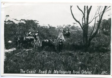
... Orbost & District Historical Society Ruskin Street Orbost ...Prior to the sealing of the Princes Highway west of Orbost, the road surface was anything but good, even by C1917 when cars started to use the road. From Orbost the old road via Marlo to Sydenham was abandoned for the new location which traversed more rugged country via Cabbage Tree, Bell Bird and Club Terrace to Cann River, and the reason for this diversion was on account of settlements being established at Murrungowar and Club Terrace, at which latter place there was a temporary rush to obtain gold. This road was constructed by the Public Works department and a maximum grade of 1 in 19 was adopted, and as speed was not to be catered for the grade followed in and out round the spurs and gullies, resulting in a maze of turns and twists which required a good deal of skill on the part of the horse driver to negotiate." - Bairnsdale Advertiser, Friday, May 2, 1947. (More information from Newsletter February 2010)n the late 1800's early 1900's transporting goods by road was difficult and at times impossible because roads as thoroughfares did not exist.The means of travelling along the roads in the 1800's was by bullock wagon, horse pulled dray, pack horse or simply by foot. This road is still in use in East Gippsland as a part of many four-wheel-drive touring routes.A large black / white photograph of two horse - drawn wagons on a narrow sandy bush track. It is surrounded by scrub. There is one man standing beside a horse not harnessed to a wagon.on front - "The Coast Road to Mallacoota from Orbost JPC" -
 Ringwood and District Historical Society
Account Book, Brown, Prior & Co, Dark purple coloured ledger with green suede spine. Applications and Allotments of shares in the Ringwood Fruit Assoc. Ltd with subsequent levies. Started 2-Dec1915 used until 1-Sep-1924, 1914
The Ringwood Fruit Association occupied the building in Adelaide Street that subsequently became 'The Mail' offices. Some nominations of committee and Rent rate notices for 1924 - 1925 under heading 'Ringwood C0-operative Cool Stores Society Ltd.Dark purple coloured ledger with green suede spine. Applications and Allotments of shares in the Ringwood Fruit Assoc. Ltd with subsequent levies. Started 2-Dec1915 used until 1-Sep-1924. +Additional Keywords: Many well known names -
Frankston RSL Sub Branch
Framed Artwork, Sketch of Frankston RSL Clubrooms, Davey Street, 1972
Framed artwork produced by artist Marie Minton, dated 1972. The artwork is an ink drawing with watercolour tonings and depicts the Frankston RSL Sub Branch clubrooms of the time. The artwork is mounted with a gold coloured wooden frame and glass front. Artist, Marie Minton was apparently the daughter of a member of the time, Laurie Minton. This scene is of a Frankston landmark building on the corner of Davey Street and Young Street, Frankston locally known as the 'Plowman Residence'. Prior to being the clubrooms of the Frankston RSL Sub Branch this building was the family home of Dr Sidney Plowman. In Dr Plowman's time the building was known as the 'The Lofts' and was his residence and operated as a private hospital, the building was constructed ca 1900. Dr Plowman died in May 1932. Title 'Frankston RSL' and the artist's name 'Marie Minton '72' appear on the front lower area of the sketch. The rear has the following note inscribed "Sketch of RSL clubrooms Davey St. by Marie Minton daughter of member (Laurie)" -
 Warrnambool and District Historical Society Inc.
Certificate - Warrnambool Legacy Club to Shire of Warrnambool
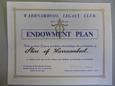
Warrnambool Legacy Club was founded in 1947; prior to that it was part of Geelong Legacy Club. It covers an area in South West Victoria bounded by Port Fairy in the west, Mortlake, Derrinallum and Lismore to the north, and Camperdown, Timboon and Port Campbell in the south and east. The Warrnambool Legacy Club has contributed to the welfare of widows and children of past soldiers. In turn it has relied upon the generosity of local organisations and people to maintain their work. The Shire of Warrnambool would have been one of many of these groups who contributed in a generous way.Cream card with gold border. Dark blue printing with Warrnambool Legacy club at the top. Legacy logo printed in gold underneath.Signed by W.G. Sinclair. warrnambool, shire of warrnambool, warrnambool legacy club, legacy club endowment plan, w g sinclair