Showing 238 items matching "railway line construction"
-
 Puffing Billy Railway
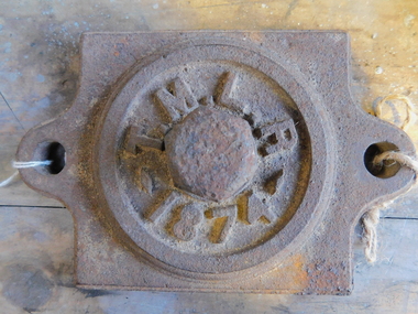
Axle Box Cover - Tasmanian Main Line Co, 1874
Axle box cover from a Tasmanian Main Line Railway rail vehicle from 1874 The Tasmanian Main Line Railway Company (T.M.R.L.) was a privately owned railway company that existed in Tasmania from 1872 to 1890. The company were the first operators of rail services between Hobart and Launceston, where it connected with the Launceston and Western Railway (L.W.R.) It started construction of a 3' 6" gauge line between Hobart and Launceston in 1873 which was completed in December 1875. and was officially opened on 1 November 1876. The route of the railway was selected largely as a result of vocal local interests and accordingly traversed some reasonably unfavorable topography, particularly in the southern section. Because the TMLR had limited finances, the line was built to the narrow (1067 mm) gauge and included long sections of steep gradients and sharp curves. The final eighteen kilometres of the route from Western Junction to Launceston used the existing broad gauge alignment of the Launceston and Western Railway, with a third rail being laid for use by the narrow gauge trains A close but uncomfortable relationship with the Government was resolved in 1890 with the purchase of the company's assets by the Crown and their incorporation into the Tasmanian Government Railways on 1 October 1890. Historic early Tasmanian Main Line Railway - Vehicle Axel Box cover Axle box cover from a Tasmanian Main Line rail vehicle from 1874.T.M.L.R - 1874 -axle, tasmanian main line railway, axle box, tasmania, main line, -
 Hume City Civic Collection
Photograph, late 1980s
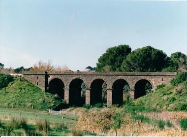
The five span masonry arch bridge over Blind Creek was one of the major constructions on the Melbourne to Echuca Railway. It was one of the first masonry rail bridges built in Victoria. Construction began in 1859 when the railway was extended from Sunbury and was designed by G C Darbyshire.A coloured photograph of the 5 arched bluestone rail bridge showing the grassy embankments on each side of the bridge and the creek flat at the base of the bridge. Some tree tops are visible on the other side of the bridge.bridges, transport, rail transport, darbyshire, g. c., blind creek, v line, george evans collection -
 Hume City Civic Collection
Photograph, late 1980s
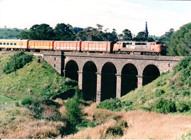
The five span masonry arch bridge over Blind Creek was one of the major constructions on the Melbourne to Echuca Railway. It was one of the first masonry rail bridges built in Victoria. Construction began in 1859 when the railway was extended from Sunbury and was designed by G C Darbyshire.A coloured photograph of the 5 arched bluestone rail bridge over Blind Creek with the embankments on either side and the tower of Rupertswood Mansion in the distance. A VLine diesel engine along with 3 goods carriages and a passenger carriage is on the bridge.bridges, transport, rail transport, darbyshire, g. c., blind creek, v line, george evans collection -
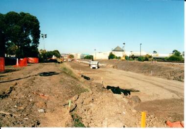
 Hume City Civic Collection
Photograph, 21/04/2005
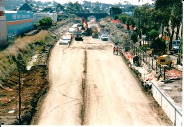
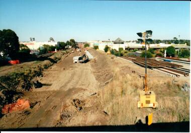
This photograph was taken during the upgrade of the Bendigo Railway line at the Sunbury Station in 2005. The upgrade took twelve months to complete and during this time bus services replaced the trains for commuters along Bendigo line.A coloured photograph of the construction on the site of the Sunbury Railway Station. The old railway lines have been removed and the bluestone road over rail bridge can be seen with excavation equipment in front of it. Concrete sleepers which replaced the old sleepers are on the LHS of the photograph.railways, bendigo line, railway stations, bridges, bluestone bridges, sunbury railway station, george evans collection -
 Hume City Civic Collection
Photograph, 21/04/2005
This photograph was taken during the upgrade of the Bendigo Railway line at Sunbury Station. The upgrade of the line took over twelve months to complete and bus services replaced the train service during that time.A coloured photograph of construction on the site of the Sunbury Railway Station. The photograph has been taken from the Macedon Street bridge and is looking south towards Station Street. The old rail tracks have been removed and excavation work is in progress to make way for the new tracks. The new rail lines have been placed on the side of the track on the RHS of the photograph.railways, bendigo line, railway stations, bridges, sunbury railway station, george evans collection -
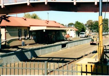
 Hume City Civic Collection
Photograph, 21/04/2005
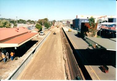
This photograph was taken during the upgrade of the Bendigo Railway line at Sunbury Station.A coloured photograph of construction on the site of the Sunbury Railway Station. The rail track has been lowered and the station platform has been narrowed to accommodate the new trains. The former bluestone wall below the platform on the Melbourne side of the station has been replaced by reinforced concrete. The rail lines have been placed along the track on the RHS of the photograph.railways, bendigo line, railway stations, bridges, sunbury railway station, george evans collection -
 Hume City Civic Collection
Photograph, 21/04/2005
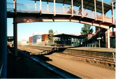
This photograph was taken during the upgrade of the Bendigo Railway line at Sunbury Station. The upgrade of the line took twelve months to complete and during that time buses replaced the train services.A coloured photograph of construction on the site of the Sunbury Railway Station. The photograph shows the pedestrian bridge and the platform for the Bendigo trains before the bluestone wall was removed and the platform was narrowed.railways, bendigo line, railway stations, bridges, sunbury railway station, george evans collection -
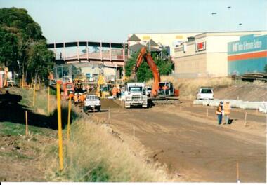
 Hume City Civic Collection
Photograph, 21/04/2005
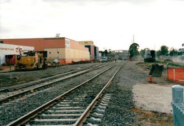
This photograph was taken during the upgrade of the Bendigo Railway line at Sunbury Station. The upgrade took twelve months to complete and during that time bus services replaced the trains.A coloured photograph of construction on the site of the Sunbury Railway Station. The photograph was taken near the Station Street level crossing and is looking north towards the Sunbury Station. The new tracks have been put into place.railways, bendigo line, railway stations, bridges, sunbury railway station, george evans collection -
 Hume City Civic Collection
Photograph, 21/04/2005
This photograph was taken during the upgrade of the Bendigo Railway line at Sunbury Station. For the twelve months when the upgrade of the line took place buses replaced the train services.A coloured photograph of construction on the site of the Sunbury Railway Station. The photograph was taken from the Macedon Street end of the station platform and shows the excavation taking place to allow for the placement of the new rail tracks.railways, bendigo line, railway stations, bridges, sunbury railway station, george evans collection -
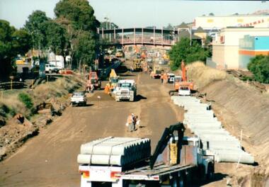 Hume City Civic Collection
Photograph, 21/04/2005
This photograph was taken during the upgrade of the Bendigo Railway line at Sunbury Station. The upgrade took twelve months to complete and during that time bus services replaced the trains.A coloured photograph of construction on the site of the Sunbury Railway Station. The photograph has been taken from the Macedon Street bridge looking south towards the station and the pedestrian bridge over the railway tracks. On the tracks the old railway lines have been removed and storm water pipes are being put into position before the new lines are to be laid.railways, bendigo line, railway stations, bridges, sunbury railway station, george evans collection -
 Hume City Civic Collection
Photograph, 21/04/2005
This photograph was taken during the upgrade of the Bendigo Railway line at Sunbury Station. The upgrade took twelve months to complete and during that time buses replaced the trains.A coloured photograph of construction on the site of the Sunbury Railway Station. The photograph was taken from the Bendigo platform and shows the concrete wall which replace the bluestone foundations on the Melbourne side of the station. A workman is on the platform working on the new surface.railways, bendigo line, railway stations, bridges, sunbury railway station, george evans collection -
 Hume City Civic Collection
Photograph, 21/04/2005
This photograph was taken during the upgrade of the Bendigo Railway line at Sunbury Station. The upgrade of the rail track took over twelve months to complete and during that time buses replaced the train services.A coloured photograph of construction on the site of the Sunbury Railway Station. The photograph has been taken from the end of the Melbourne platform and shows the various pieces of machinery, which included an excavator, a fork lift and trucks, that were used in the work on the line.railways, bendigo line, railway stations, bridges, sunbury railway station, george evans collection -
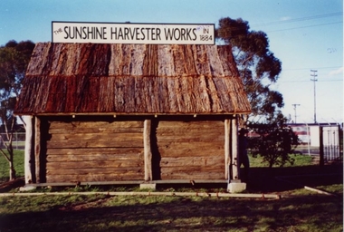 Sunshine and District Historical Society Incorporated
Replica of McKay Smithy, Opened on 10 October 2001
This Smithy is a replica of the building in which the first H. V. McKay harvester was built at Drummartin in northern Victoria in 1884. The original Smithy was moved from Drummartin to Sunshine Victoria where it remained for many years outside the H. V. McKay manufacturing plant. With the construction of the standard gauge railway line the road outside the Smithy was demolished, and the original Smithy was taken to the Melbourne Museum.The original Smithy is now in a fragile state and is no longer on public display at the Melbourne Museum. The site where the original Smithy stood in Sunshine was no longer available so the replica Smithy was erected a few hundred metres away, in the South East corner of Barclay Reserve on King Edward Ave, Albion 3020.The replica Smithy permits the public to view a full sized model of the building which eventually led to the formation of the H. V. McKay Sunshine Harvester Works. This firm grew to being considered the main manufacturing plant in the southern hemisphere, and also led to the local area being renamed in 1907 from Braybrook Junction to Sunshine.Brown wooden building with bark roof. This building is a FULL SIZED REPLICA of the original SMITHY that was used by H. V. McKay.THE SUNSHINE HARVESTER WORKS 1884smithy, h. v. mckay, sunshine harvester works, drummartin, replica, massey harris, massey ferguson -
 Sunshine and District Historical Society Incorporated
Photographs (1928), 'QUARTER MILE' BRIDGE Construction, 1928
One man lost his life during the building of this bridge. The bridge was constructed by the Victorian Railways between 1927 to 1929 to carry a new double track goods line. This enabled trains from all parts of the state except Gippsland to have direct access to the Tottenham marshalling and sorting yards. These yards were constructed in the 1920's to relieve congestion in the Melbourne Yard near Spencer Street station. The congestion was being caused by the construction of suburban passenger platforms associated with the electrification of the suburban railway network. Initially the bridge was for goods trains but during the Second World War it was also used by troop trains. When the standard gauge line was built in 1962 all trains to Albury and Sydney have used this route, thus avoiding travelling through Essendon and Pascoe Vale on the suburban tracks. The standard gauge track across the bridge took the place of one of the broad gauge tracks so broad gauge trains crossing the bridge in either direction have to now use the same track. The bridge is 1,257 feet (383.13 metres) long and 180 feet (54.86 metres) above the water level. It is just 63 feet (19.2 metres) short of a quarter mile in length between abutments. There is a similar bridge on the same railway line crossing the Moonee Ponds Creek between Gowenbrae and Glenroy, however it is smaller at 1060 feet (323.08 metres) length and 115 feet (35.05) height.The bridge is now Victorian Heritage Registered under Number: H1197, and Heritage Overlay Numbers HO5, and HO107. On the Heritage Register it is named RAIL BRIDGE (ALBION VIADUCT). According to the Heritage Report the bridge is scientifically and architecturally important because of its large size, and because of the cost effective design features such as two girders per span (one for each track), the K bracing in the towers, and the broad flange beams as columns. When it was being built it was the largest trestle bridge in Australia, and until the Sydney Harbour bridge was constructed it was the highest railway bridge.Five B&W yellowing photos showing stages of construction of the Maribyrnong River Viaduct known as the Trestle Bridge but mainly known locally as the QUARTER MILE BRIDGE. It is a railway only bridge which runs over the Maribyrnong River between Sunshine North and Keilor East. A sixth image, which is not part of this set of photos, is included to show what the completed bridge looks like. -
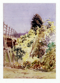 Nillumbik Shire Council
Painting: Walter WITHERS (b.1854 Warwickshire, UK — d.1914 Eltham, Aus), Trestle Bridge, Eltham, c.1903-10
Walter Withers was a significant Australian landscape artist and a member of the Heidelberg School of Australian Impressionists. In 1903 Withers bought 'Southernwood', a house on 2½ acres (1 ha) at Eltham, to which he added a studio. Because of ill health, he lived during the week at his studio in Oxford Chambers, Melbourne, and on weekends and holidays with his family at Eltham until his death in 1914. The Eltham rail bridge is a unique and valuable historic relic of an earlier steam locomotive transport era in the Diamond Creek Valley and has long formed an important part of a magnificent Eltham landscape. When built in 1902 it was close to the terminus point of the Heidelberg-Eltham rail extension, on the route of the proposed Diamond Valley Railway that was then planned to continue much further up the valley towards Kinglake. This bridge is situated in attractive river-valley parkland amidst the tall and spreading manna gums and candlebarks of the Diamond Creek Valley. The Alistair Knox Park river-valley landscape, of which the timber trestle bridge is an important visual component, has been classified by the National Trust. Large manna gum and candlebark trees adorn the adjacent creek banks, and historic Shillinglaw Cottage is also part of this much-prized Eltham landscape. Eltham is home to a historic wooden railway trestle bridge. Mainly of timber-pier and timber-beam construction, but varied by a few longer steel-joists spans on timber piers at the main stream channel, this substantial bridge has almost two hundred metres of timber deck. Built in 1902, it is the only railway bridge of predominantly timber construction that is still in regular use as an integral part of Melbourne's metropolitan electric railway network and one of extremely few timber rail bridges in the State that still carry trains. Apart from its important continuing social function as a carrier of rail transport for the Hurstbridge line, this impressive bridge and its beautiful parkland environs contribute much to the character of Eltham township and that town's special reputation as an historic centre of environmental and conservation concerns. This section of the Diamond Creek Valley was the subject of a Walter Withers painting in the earliest years of the twentieth century and has strong historic links with our Heidelberg School of painters. Watercolour painting on paper of Eltham's Trestle Bridge in the middle of the day. A small section of the wooden bridge is located to the left of the painting. The focus is predominately on the wattle, manna gum and candlebark trees that is to the right of the bridge. The golden hues typically represent the australian sunlight and landscape. "W.W" in gothic script on the lower right side of the painting. Not dated. withers, eltham, trestle bridge, railway, watercolour -
 Stawell Historical Society Inc
Map, Crowlands & Navarre Railway Construction Trust, VR Plan Showing Railway Construction District Crowlands to navarre Line 1916, 4 July 1916
Two (2) Very large Coloured Maps. Scale 40 Chains to 1 Inch. rail Line Drawn in RedShire of Kara Kara. Shire of Stawell Shire of Ararat 4 July 1916railways -
Stawell Historical Society Inc
Map, Rupunyup and Marnoo Railway Construction District 1900, 11/06/1908
Map Shows Rail Lines. Glenorchy Lubeck Rupunyup Marnoo Murtoa MinyipMap Showing line to be Constructed from Rupunyup to Newall's Corner Marnoo.Marnoo Railway Trustrailways -
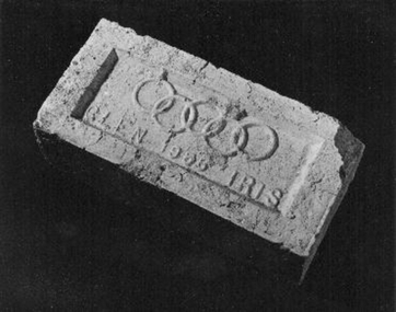 Whitehorse Historical Society Inc.
Memorabilia - Brick, 1956
The brick was used in the construction of a toilet block located behind the Blackburn Library and next to the railway line. it was donated by the City of Whitehorse after the toilet block was demolished in 1999.1956 Olympic Glen Iris cream brick'Glen 1956 Iris' with Olympic ringsbuildings, materials -
 Ballarat Heritage Services
Photograph - Photograph - Colour, Clare Gervasoni, Nimon's Bridge, 1999, 04/10/1999
Nimons Bridge was built in 1890, as part of the then Ballarat-Linton railway. The bridge is 17 spans with tall timber piers of four driven piles each, with triple sets of diagonal cross-bracing and walers and a single row of longitudinal horizontal bracing between piers. The spans are of a uniform twenty feet (6.1 metres), originally supported by four 21-inch x 9-inch (535 mm x 230 mm) Kauri timber beams per span, following the standard V.R. design of the period. When the superstructure was rebuilt after the 1953 fire, the timber beams were replaced with two 24-inch (610mm) deep rolled-steel-joists on each span. These are marked 'Lancashire Steel Co., Scotland' and are believed to have been second-hand. The deck of transverse-timber planks is 103.6 metres in length. Overall the bridge has an impressive appearance with its exceptionally tall triple-cross-braced piers creating a 'three-tiered' effect, with the deck 19.2 metres above the Woady Yaloak River. The Ballarat-Skipton line closed in 1985. Nimons Bridge has been recently restored, as part of the Ballarat-Skipton Rail Trail. How is it significant? Nimons Bridge is significant for technical, historic and aesthetic reasons at a State level. Why is it significant? Nimons Bridge is technically significant as Victoria's fourth-tallest timber trestle bridge when built, and as the third-tallest surviving example. It is also the second-largest composite bridge combining traditional timber piers with RSJ spans and a timber deck and falls within a select group of fewer than ten timber railway bridges with horizontal longitudinal bracing between the piers and three sets of double cross-bracing on its tallest piers, creating a visually striking 'three tiered' effect that enhances its viaduct form. Nimons Bridge is historically significant as having served initially the mining community at Linton, then the Western District agricultural area and in later years a kaolin quarry at Pittong. Nimons Bridge is historically significant as a representative of the 'light' branch line methodology that stimulated the explosion of railway construction in Victoria during the 1880s, and provides an interesting contrast with the more solid and vastly more expensive railway viaducts built in similar terrain on Victorian main lines, at Moorabool and Taradale, in the late 1850s. Approached by a deep cutting and high embankment at either end, the bridge represents a very cost-effective late 19th century engineering solution to the characteristic physiography of western Victoria with flat basalt plains intersected by deep wide valleys occasionally subject to severe flooding. Nimons Bridge is aesthetically significant for its visually impressive viaduct form, crossing a deep and steep-sided valley that is part of a rich cultural landscape. Within close proximity of the bridge are mullock dumps, tailings, shaft sites and other relics of the deep-lead alluvial mining era. The bridge is the most visually spectacular timber-trestle rail bridge in Western Victoria and is among the most spectacular timber-trestle rail bridges surviving anywhere in Victoria. It is part of the Ballarat-Skipton Rail Trail. Classified by the National Trust :02/10/2000 (http://vhd.heritagecouncil.vic.gov.au/places/67986)Colour photograph of a log bridge known as Nimon's Bridge.ballarat-linton, nimons bridge, nimon's bridge, log bridge, viaduct, timber-trestle rail bridge -
 Whitehorse Historical Society Inc.
Document, Heatherdale Spur, 18/11/2022
The history of Heatherdale Spur and the construction of the railway stationnon-fictionThe history of Heatherdale Spur and the construction of the railway stationheatherdale railway station, heatherdale community action group inc. -
 Otway Districts Historical Society
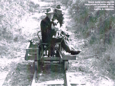
Photograph, R. Preston, Trolleying to work site, 1955, 14 December 1955
At its peak the Beech Forest railway employed more than 21 staff between Colac and Crowes. Gangers (men in charge of the track gangs) tended to be promoted into the Otways but many of their subordinate repairers were local recruits. A few of the men who worked in the original construction gangs of 1900-1902 remained and obtained positions in the track gangs along the line. The track was maintained by seven three-man gangs based at Colac, Barongarook, Gellibrand, Banool, Beech Forest (2), and Lavers Hill. However, track gangs lessened as the line shortened. After 1954, the sole surviving track gang, in charge of Paddy Balcombe, stayed until the line closed.A railway track gang, with helper, trolleying to a work site, on 14 December, 1955.beech forest; railways; track gang; -
 Otway Districts Historical Society
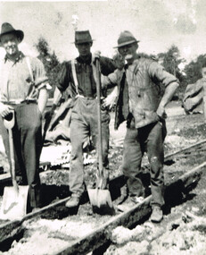
Photograph, Barongarook track gang, c.1925, c.1925
At its peak the Beech Forest railway employed more than 21 people between Colac and Crowes tending the line the trains ran over. The gangers (the men in charge of the track gangs) tended to be promoted into the Otways but many of their subordinate repairers were local recruits. A few of the men who worked on the original construction gangs of 1900-1902 remained and obtained positions in the track gangs along the line. The track was maintained by seven three-man gangs based at Colac, Barongarook, Gellibrand, Banool, Beech Forest (2), and Lavers Hill. The ganger for Beech Forest 2 gang resided at Wyelangta. However, the track gangs lessened as the line shortened. Three men with spades on the line, thought to be at Barongarook, c.1925. B/W.barongarook; railways; track gangs; -
 Otway Districts Historical Society
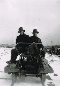
Photograph, Woosnan, Frank, Track gang at Beech Forest, c.1940, c.1940
At its peak the Colac-Beech Forest-Crowes railway employed more than 21 staff tending the lines that the trains ran over. Gangers (the men in charge of the track gangs) tended to be promoted into the Otways but many of their subordinate repairers were local recruits. A few of the men who worked on the original construction gangs of 1900-02 remained and obtained positions in the track gangs along the line, but these eased out over time. The track was maintained by seven three-man gangs based at Colac, Barongarook, Gellibrand, Banool, Beech Forest (where the second Beech Forest crew was based at Wyelangta), and Lavers Hill.Track gang on an NK wagon at Beech Forest, c.1940. Snow covers the ground. B/W.colac; beech forest; crowes; railway; track gangs; -
 Otway Districts Historical Society
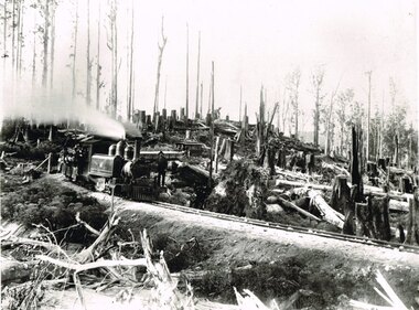
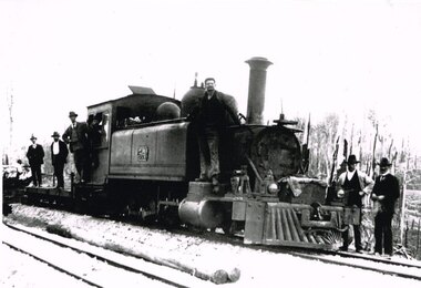
Photograph, Victorian Railways, Between Devitt Bros. Siding & Ditchley, 1901, 1901
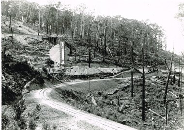
Construction of the Colac-Beech Forest railway line began in 1900 with about 100 men engaged in laying and ballasting the track, as well as others forming the earthworks and building culverts and bridges. The result of this labour saw the railway advance from Colac until it climbed a spur hugging the side of a forty degree slope emerging on top of the ridge at Beech Forest. This photograph was taken 28 miles (45 kilometres) from Colac between Devitt Bros. Siding and Ditchley, just out of Beech Forest. Two 2-6-2 Tank engines of the narrow-gauge A class built by Victorian Railway's Newport workshop, were commonly dubbed 'Coffee Pots'. As well as pulling a load of NQR wagons a NBB saloon car ended the train. The devastation to the standing timber was deliberate: the Engineer-in-Chief of VR ruled that all trees within a certain distance of the railway line were to be cut down. This certainly saved the line from destruction several times in the future.B/W. An NA class locomotive, NQR wagons and an NBB saloon car, all with workmen, going around a bend between Devitt Brother's Siding and Ditchley on the Beech Forest line in 1901.beech forest; ditchley; devitt bros siding, railways; -
 Otway Districts Historical Society
Photograph, Brucker, Beech Forest: Locomotive 5A during construction, c.1902, c.1902
In 1898 a recommendation for a railway of 2 ft 6 in gauge was handed down by the Parliamentary Standing Committee on Railways, to cost $138,000. Construction began in 1900. About 100 men were engaged in laying and ballasting the track while others, not included in the 100, formed the earthworks, culverts and bridges. Locomotive operations initially were two 2-6-2 Tank engines of the narrow gauge A class, dubbed "Coffee Pots", and these were used on the work trains between 1900 and 1902. Because of the lengthy periods of waiting time required to unload sleepers and rails or to load ballast meant that a handy replenishment of coal and water supply was necessary. With earthworks specified to the bare minimum landslips in the narrow cuttings were frequent so a repairer was stationed in each length to deal quickly with minor slips until 1904 when the cuttings were widened.B/W. The driver and seven other men on locomotive 5A and its flat cars at Beech Forest during construction of the line in c.1902. beech forest; railways; loco 5a; -
 Otway Districts Historical Society
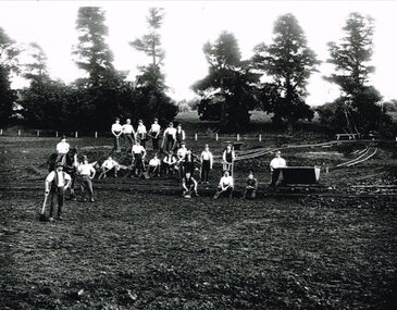
Photograph, Narrow gauge construction camp near Colac, c.1900
Construction of the Colac-Beech Forest railway line commenced in 1900 and the first activities were the work gangs and their camps. About 100 men were engaged in laying and ballasting the track while others formed the earthworks and the building of culverts and bridges. The first camp was established eight kilometres from Colac, the second 12 km south, and the remainder spaced at similar distances as the work progressed. The camps were served by butchers and bakers from Colac that visited them as many times each week to satisfy the mens' requirements. Many of the men had their families with them. They all lived in tents that consisted of a wooden floor around which the canvas cover was built. A calico partition divided the eating and sleeping quarters, and all cooking was done in camp ovens or at open fires.B/W. 158mm x 203mm. Near Colac, a narrow gauge construction camp comprising 21 workmen, a horse, and two tipping trays.construction camp; railways; colac; -
 Otway Districts Historical Society
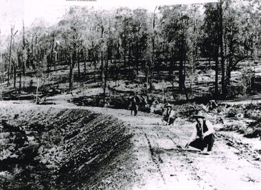
Photograph, Knox Collection, Surveying construction near Barongarook, 1900, 1900
In 1898 a recommendation for a railway of 2 ft 6 in gauge was handed down by the Parliamentary Standing Committee on Railways, to cost $138,000. Construction of the Colac-Beech Forest railway line began in 1900. About 100 men were employed in laying and ballasting the track while others formed the earthworks and the building of culverts and bridges. The earthworks of gravel ballast 150 mm deep were formed by horse and scoop or by shovel. Once the bed had been laid surveyors went along to check the layout, particularly all check rail curves and all 100 metre curves which the surveyors in the picture are doing.B/W. Three men surveying the construction of a curved bed on which track will be laid, near Barongarook, Victoria.colac; beech forest; barongarook; railways; -
 Otway Districts Historical Society
Photograph, Victorian Railways, Gellibrand ballast pit siding, c.1902
In 1902 a ballast siding was opened 4 km south of Gellibrand to provide materials for track construction. A spur siding with a capacity for six trucks was cut into the side of a slope. Above this was erected a loading bin and chute. The stone proved to be of durable quality so the siding continued after 1902 for periodic track re-ballasting works. The points were set for the main line and spiked shut when the siding was not in use. By the mid-1920s the Victorian Railways found it more economic to use ballast from Penshurst, so the siding was closed by 1925 and the rails lifted.B/W. Gellibrand ballast pit siding at 19 miles (30.6 km) south of Colac. gellibrand; gellibrand siding; railways; -
 Bendigo Historical Society Inc.
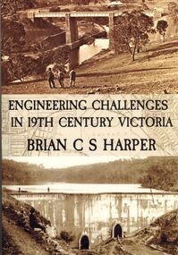
Book - ENGINEERING CHALLENGES IN 19TH CENTURY VICTORIA
... on the construction of the Bendigo Railway Line, Coliban Water Scheme, Lower... Railway Line, Coliban Water Scheme, Lower Stony Creek Dam ...Engineering Challenges in 19th Century Victoria by Brian C S Harper, or Brian Harper, soft cover 256 pages with black and white photographs. Book includes information on the construction of the Bendigo Railway Line, Coliban Water Scheme, Lower Stony Creek Dam, the Saltwater Railway Bridge, and the Taradale Railway Viaduct. Transferred to Specimen Cottage for use June 2016 Missing from Specimen Cottage. Check sale items 8.12.22Brian C. S. Harperbooks, technical, engineering -
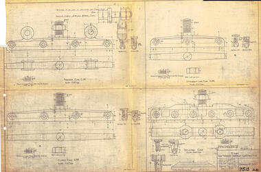 Ballarat Tramway Museum
Drawing, Victorian Railways (VR), Ears for Tramway Overhead Construction, 1924
Gives the design details of the device or fitting known as a trolley wire ears that holds a tramway copper trolley wire in position. Notes that the drawing was traced in 1924 from a MMTB drawing. Has details for a splicing ear, straight line ear. feeder ear and curve ear along with details for nuts and screws.Yields information about the design of four different types of trolley wire fittings and how they were fabricated for use on the two tram lines, or electric street railways operated by the Victorian Railways.Dyeline print of Victorian Railways drawing number 4057 - Ears for Tramway Overhead ConstructionHas number "7513 D.33" in black pen in bottom right hand corner.tramways, trams, overhead, victorian railways, trolley wire, engineering, electrical engineering