Showing 420 items
matching renovated building
-
 Kew Historical Society Inc
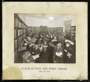
Photograph, C Stuart Tompkins, Junior Section, Kew Public Library, 15 May 1945
... was closed for a major overhaul of stock and renovation... of stock and renovation of the building. It reopened in December ...1860: Kew's first library was the Kew Literary and Scientific Society, which opened on 6 August 1860. 1884: Kew Town Hall was extended and the library transferred to a room on the upper floor. This was not an ideal arrangement as the room was required for Council purposes. 1904: A cottage adjoining Kew Town Hall was purchased for use as a library. 1937: The library was closed for a major overhaul of stock and renovation of the building. It reopened in December 1937 and remained there for more than 35 years. 1973: When the Civic Centre opened in Charles Street, Kew, the library moved in. 1987: Kew Library moved to its current location in the converted city hall, overlooking the beautiful Alexandra Gardens. The library was officially opened at this site on Friday 23 October 1987 by the Mayor of Kew, Cr James Tutt. (Source: Boroondara Library Service)Early original photograph of a children's library service taken by a notable Melbourne photographerOriginal photograph, in original frame, of the Junior Section of the Kew Public Library in Walpole Street, Kew. The photograph was taken by Stuart Tompkins who was the photographer of choice by the City of Kew from the 1930s to the 1960s. The details of the photograph are inscribed on the water-damaged mount, with the photographers signature at lower right. . "Junior Section, Kew Public Library, May 15th 1945"kew public library, photographers - c. stuart tompkins - camberwell (vic), children's libraries -
 Kew Historical Society Inc
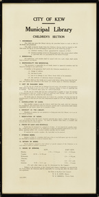
Document, City of Kew, City of Kew Municipal Library, Children's Section, 1953
... was closed for a major overhaul of stock and renovation... of stock and renovation of the building. It reopened in December ...1860: Kew's first library was the Kew Literary and Scientific Society, which opened on 6 August 1860. 1884: Kew Town Hall was extended and the library transferred to a room on the upper floor. This was not an ideal arrangement as the room was required for Council purposes. 1904: A cottage adjoining Kew Town Hall was purchased for use as a library. 1937: The library was closed for a major overhaul of stock and renovation of the building. It reopened in December 1937 and remained there for more than 35 years. 1973: When the Civic Centre opened in Charles Street, Kew, the library moved in. 1987: Kew Library moved to its current location in the converted city hall, overlooking the beautiful Alexandra Gardens. The library was officially opened at this site on Friday 23 October 1987 by the Mayor of Kew, Cr James Tutt. (Source: Boroondara Library Services)Historically and socially significant set of regulations governing the use of the children's library in Kew in the early 1950sOriginal framed rules and regulations of the junior section of the Kew Library, dated 16.6.1953, authorised by the Mayor (W.E.R. Hope) and Town Clerk (W.D.Birrell). The document also lists opening hours of the Kew and East Kew branches.kew public library - kew (vic), kew public library - east kew (vic), city of kew - library guidelines -
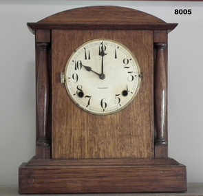
 Kew Historical Society Inc
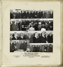
Photograph, Stuart Tompkins Studios, Kew Municipal Library: Opening of Extentions by The Hon. L.W. Balvin M.L.A. Chief Secretary, 19 October 1954
... : The library was closed for a major overhaul of stock and renovation... was closed for a major overhaul of stock and renovation ...Kew Library history: 1860: Kew's first library was the Kew Literary and Scientific Society, which opened on 6 August 1860. 1884: Kew Town Hall was extended and the library transferred to a room on the upper floor. This was not an ideal arrangement as the room was required for Council purposes. 1904: A cottage adjoining Kew Town Hall was purchased for use as a library. 1937: The library was closed for a major overhaul of stock and renovation of the building. It reopened in December 1937 and remained there for more than 35 years. 1973: When the Civic Centre opened in Charles Street, Kew, the library moved in. 1987: Kew Library moved to its current location in the converted city hall, overlooking the beautiful Alexandra Gardens. The library was officially opened at this site on Friday 23 October 1987 by the Mayor of Kew, Cr James Tutt.An historically interesting photographic record of investment in public infrastructure and services by municipal councils during the 1950s. Framed photographic collage showing the opening of Extensions to the Kew Municipal Library by The Hon. L.W. Balvin M.L.A. Chief Secretary on 19 August 1954. The photos are in their original mount and frame.[Inscription] "Kew Municipal Library: Opening of Extentions by The Hon. L.W. Balvin M.L.A. Chief Secretary 19.8.1954, with Cr. A.S.C. Stevens J.P. Mayor and Cr. W.D. Vaughan J.P. Chairman Library Council". [Photographer] "Stuart Tompkins Studios."kew library, cr a.s.c. stevens, cr w.d. vaughan, australian photographers - stuart tompkins studio -
 Otway Districts Historical Society
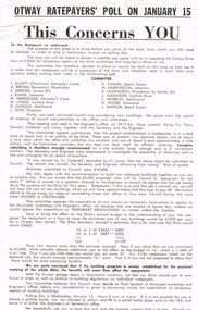
Poster, Colac Herald, Otway Ratepayers' Poll Flyer, 1963, 1963
... -Committee's recommendation to Council of a new, adequate building... for loans for temporary renovations of existing buildings ...On 15 January 1964 the Shire of Otway was going to poll its ratepayers about a loan required to build temporary municipal workshops and a Shire Engineer's office in the Apollo Bay Riding. This led to a number of objections at public meetings in the west and central ridings, such that a Committee of protest was formed, with a nominated Chairman, Secretary and members, to put to ratepayers their considered point-of-view of disapproval. After drafts the Committee produced a printed flyer for distribution to ratepayers summarising the Committee's position. The Committee knew and agreed with a Council Sub-Committee's recommendation to Council of a new, adequate building on one site of suitable size. However, this did not happen. Instead Council moved for loans for temporary renovations of existing buildings. This the Committee objected to believing that Council must decide on a final location before any consideration is given to borrowing money for temporary repairs. This was the opinion the Committee put to ratepayers.B/W Flyer. Otway Ratepayers' Poll on January 15. This concerns YOU. To the Ratepayer as addressed. Details on Ballot Paper.ratepayers; shire of otway; -
 Bacchus Marsh & District Historical Society
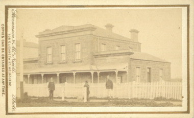
Photograph, Court House Main Street Bacchus Marsh 1883
... . The front courtyard of the building has been renovated since... been renovated since, but this building still operates ...The Court House in Main Street Bacchus Marsh was built in 1858 using local sandstone. It opened in 1859. It has been used for jury trials, a Court of Petty Sessions, a County Court and a Crown Land sales office. Other uses included an office for the Registrar of Births and Deaths, a Dairy Inspectors office from 1863-1865, and as meeting rooms for the Bacchus Marsh Roads Board, a forerunner of the Shire Council. It was also used by the Bacchus Marsh Shire Council for its offices until at least 1884. In more recent years it has functioned as a Magistrates Court with weekly court sessions. Small sepia unframed photograph on card with gold border framing photograph. Housed in the album, 'Photographs of Bacchus Marsh and District in 1883 by Stevenson and McNicoll'. The view of the Court House building is seen from the northern side of Main Street looking south or south-east. Three men are standing in the street in front of the building. The men on the left and the right wearing police helmets appear to be police officers. The man in the middle is in civilian clothes and might be an officer or employee of the Court House. He has his dog with him. A white picket fence runs along the front of the building. The front courtyard of the building has been renovated since, but this building still operates as a court house.On the front: Stevenson & McNicoll. Photo. 108 Elizabeth St. Melbourne. COPIES CAN BE OBTAINED AT ANY TIME. On the back: LIGHT & TRUTH inscribed on a banner surmounted by a representation of the rising sun. Copies of this Portrait can be had at any time by sending the Name and Post Office Money Order or Stamps for the amount of order to STEVENSON & McNICOLL LATE BENSON & STEVENSON, Photographers. 108 Elizabeth Street, MELBOURNE. stevenson and mcnicoll 1883 photographs of bacchus marsh and district, courthouses, bacchus marsh court house -
 Vision Australia
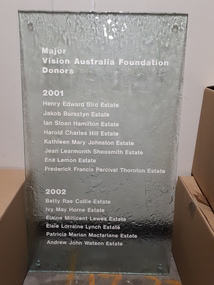
Photograph (Item), Major Vision Australia Foundation donors 2001 and 2002
... , particularly for building or renovation projects. In 2001 and 2002... for building or renovation projects. In 2001 and 2002, the following ...To assist in providing services, Vision Australia Foundation needed to raise additional funds through donor relations, particularly for building or renovation projects. In 2001 and 2002, the following donors were recorded as providing a substantial amount of funding towards this and were commemorated with a glass plaque displayed in the building. The following names (estates) were listed: 2001 - Henry Edward Bird Estate, Jakob Bursztyn Estate, Ian Sloan Hamilton Estate, Harold Charles Hill Estate, Kathleen Mary Johnston Estate, Jean Learmonth Shoosmith Estate, Ena Lemon Estate, Frederick Francis Percival Thornton Estate. 2002 - Betty Rae Collie Estate, Ivy May Horne Estate, Elaine Millicent Lewes Estate, Elsie Lorraine Lynch Estate, Patricia Marian Macfarlane Estate, Andrew John Watson Estate.Major Vision Australia Foundation donors vision australia foundation, nameplates -
 Wodonga & District Historical Society Inc
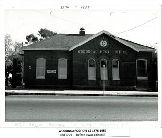
Photograph - Codling Collection 01 - Wodonga Post Office
... . This building, greatly renovated, is now part of the Wodonga Community... further south in High Street. This building, greatly renovated ...Miss Olive Codling was a Foundation Member and a Life Member of the Wodonga Historical Society. Many of her photos are held in the Society Collection. The Wodonga Post Office was constructed on the corner of Sydney Road (High Street) and South Street in 1874. It was Wodonga’s second Post Office. The original post office opened on June 1, 1856 near Wodonga Creek. This building was originally built of red brick, although it was later painted over in white. It had an attached residence in South Street and was connected to it by a door. The residence was later demolished to move the mail boxes which had faced High Street, to South Street. The brick Telephone Exchange was constructed in 1946 behind the Post Office but separated from it. It operated as a manual exchange until the late 1960’s or early 1970’s. In 1985 a new post office was opened further south in High Street. This building, greatly renovated, is now part of the Wodonga Community College.This photo collection is significant as it documents how the businesses and buildings in Wodonga have evolved and contributed to community throughout the 20th century. A black and white image of the 2nd Wodonga Post Office. There are 6 windows across the front of the building and the name Wodonga Post Office below a round clock. To the left of the building is the royal insignia of the crown above the letters E.R. A sign for the Commonwealth Saving Bank of Australia is also attached to the wall.high st wodonga, wodonga post office, businesses wodonga -
 The Beechworth Burke Museum
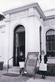
Photograph, c.1980
... '. The building was turned into a museum and renamed the Robert O'Hara...'. The building was turned into a museum and renamed the Robert O'Hara ...This photograph depicts the entrance to the Burke Museum in Beechworth, most likely in 1980. The building was originally established as the Beechworth Athenaeum in 1857 to provide a lecture hall and reading room at the peak of the gold rush. In 1859, it became the Beechworth Public Library, which is why the writing embossed above the main entry says 'Library' rather than 'Museum'. The building was turned into a museum and renamed the Robert O'Hara Burke Memorial Museum in 1863 in honour of Robert O'Hara Burke, former Police Superindendent of Beechworth who died in 1861 on the Burke and Wills expedition. The Burke Museum has been in almost continual operation since that time. In the 1970s, the building underwent renovations to create several verandas, though the main façade visible in this photograph remained as it was when originally built. The Burke Museum currently contains over 30,000 individual objects, including the Gold Rush era items and the Ned Kelly collection advertised on the a-frame in the photograph. The photograph itself is also part of the Burke Museum collection.The Burke Museum itself is very significant to Victorian history. It is on both the Victorian Heritage Register and is part of the National Trust due to its relevance to the history of the Gold Rush period, its architectural features, and its significant collection. Photographs of it throughout its history are an important part of telling the museum's story. This photograph in particular highlights what the museum staff believed would be appealing to a 1980s public, evident by the A-frame advertising board.A black and white rectangular photograph printed on photographic paper.Top right text: 5147. Bottom left text: Beryl Seatt (or possibly Scatt) & friend 1980beechworth, burke museum, beechworth museum, beechworth historic precinct, architecture, museum, library, 1980s, 1980s australia, museum staff -
 Glen Eira Historical Society
Document - GLEN EIRA ACTIVITY CENTRES
... use, building renovations, street renovations, public..., and is divided into six subsections pertaining to land use, building ...This file contains three items pertaining to the draft of the Glen Eira Activity Centre Strategy, each dated 11/2004 and composed by Peter McNabb and Associates Pty Ltd. (Unknown author of handwritten notes by John Campbell, Mayor of Caulfield 1986-87 and long-time observer of the Caulfield Council/Glen Eira Council): 1/A 53-page Overview Report, summarising the research conducted into the existing state of Glen Eira’s Activity Centres for the purposes of devising a Strategy to improve them. The Report constitutes the first of four components of a broader document termed the ‘Position Paper’, of which the remaining three are not present. The Report is divided into ten sections. The first is an executive summary of the entire document. The second is an introduction that explains the reasons why the Glen Eira City Council chose to embark upon this project. The third describes the methodology by which the research was conducted. The fourth describes what an Activity Centre is defined as. The fifth describes pre-existing policies and strategies pertaining to commercial development. The sixth describes the regional context of Glen Eira’s Activity Centres. The seventh describes the factors affecting Glen Eira’s Activity Centres plus the changes resulting from them, and is divided into four subsections pertaining to demographics, economics, decentralisation and housing, respectively. The eighth describes patterns of activity within Glen Eira’s Activity Centres, containing, for example, tables illustrating the number of particular types of businesses within each Centre. The ninth describes the new classification system for Glen Eira’s Activity Centres, the category each of Glen Eira’s Activity Centres belongs to under this system, and the future roles of each of the Centres. The tenth briefly recaps the entire document. Also included are three colour maps of Glen Eira noting the locations of existing Activity Centres. Handwritten notes and queries feature throughout, but the author thereof is unknown. 2/A 37-page Consultant Report issued for public comment, describing the draft of the Strategy to improve Glen Eira’s Activity Centres that has been formulated based on the data outlined in the Position Paper. The report is divided into six sections. The first is an introduction. The second describes the methodology used to develop the Strategy. The third describes the vision of Glen Eira’s Activity Centres plus the objectives necessary to achieve it. The fourth describes the new classification system for Glen Eira’s Activity Centres, the category that each of Glen Eira’s Activity Centres belongs to under this system, and future roles of each of the Centres. The fifth describes the improvements recommended for the Centres, and is divided into six subsections pertaining to land use, building renovations, street renovations, public transport, traffic plus parking, and marketing plus management, respectively. The sixth, finally, describes the amendment that ought to be made to the Glen Eira Planning Scheme on account of the Overview Report. Also included is a black-and-white map of Glen Eira noting the locations of existing Activity Centres. Again, handwritten notes and queries feature throughout, but the author thereof is unknown. 3/A 3-page summary of the draft, briefly outlining what the strategy is, why it has been prepared, what an Activity Centre is defined as, what the major influences of Glen Eira’s Activity Centres are, how the community has been consulted, what the key findings of the research process have been, what the process from here shall be, and how one can comment on the Strategy. Also included are three colour maps of Glen Eira noting the locations of existing Activity Centres.glen eira, city of glen eira, glen eira activity centre strategy, glen eira activity centres strategy, activity centres, peter mcnabb & associates pty. ltd., peter mcnabb and associates pty. ltd., glen eira city council, glen huntly, ormond, mckinnon, gardenvale, caulfield park, caulfield, murrumbeena, beauville estate, murrumbeena road, oakleigh road, carnegie, neerim road, hewitts road, ormond, koornang road, leila road, north road, caulfield park, kooyong road, gardenvale road, elsternwick, patterson, mckinnon road, bentleigh, alma village, phoenix precinct, parnell street, commercial development, commercial strategy, town planning, melbourne 2030, glen eira planning scheme, local planning policy framework, municipal strategy statement (mss), demography, economics -
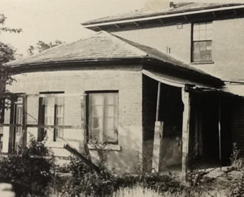
 Eltham District Historical Society Inc
Photograph - Digital Photograph, Marguerite Marshall, Jelbart home, 93 Arthur Street, Eltham, 11 November 2006
... family, have lived in and extensively renovated both buildings... family, have lived in and extensively renovated both buildings ...Situated at the top of the hill in Arthur Street, the former Jelbart residence and barn were part of a major change that transformed Eltham's character in the late 1960s. Built from the mid 1940s through mid 1950s when Eltham was a rural community, the Jelbrat residence and barn are all that remain of a family property of some 250 acres (100 ha). With growing population pressures, in the late 1960s, owners Ron and Yvonne Jelbart decided to subdivide their property creating the Woodridge Estate in the early 1970s, a major factor towards the transformation of Eltham to the suburb it is today. The Jelbarts had moved to Eltham in the early 1940s when they purchased a poultry farm in New Street, now Lavendar Park Road. (The local Black Friday bushire of January 13, 1939 had started at C.A. (Clarrie) Hurst’s Eltham Poultry Farm and Hatchery in New Street.) Jelbart was primarily a businessman importing office machinery but desired farm beef and dairy cattle so the couple purchased the virgin bushland at what was then at the end of a dirt road, Arthur Street. With post war shortages of most building materials, they followed the example of the Eltham Artists' Colony (later called Montsalvat) and built thier home from mud-bricks and recyclked materials. The barn was first to be completed in 1945 which they made their home whilst building the main residence. It took eight years to complete the two buildings. Both the main residence and the barn are now separate homes, and along with the remaining property being sub-divided further in 1998 are now part of the Kinloch Gardens Estate at 93 Arthur Street. Covered under Heritage Overlay, Nillumbik Planning Scheme. Published: Nillumbik Now and Then / Marguerite Marshall 2008; photographs Alan King with Marguerite Marshall.; p139 Standing on a hilltop at Arthur Street, Eltham, the Jelbart residence and former barn were part of a major change that transformed Eltham’s character in the late 1960s. Built from the late 1940s to the mid 1950s when Eltham was a rural community, they are all that remain of what was once a family property of around 250 acres (100 ha). As population pressure increased in the late 1960s, owners Ron and Yvonne Jelbart, decided to subdivide their property. The break-up of this property into the Woodridge Estate in the early 1970s, was a major factor towards transforming Eltham into the suburb it is today.1 Although standing only a few minutes from Eltham’s busy hub and hundreds of houses in Woodridge, scarcely any urban sound disturbs the peace. Views from the two buildings are almost exclusively of trees and extend to Mt. Dandenong to the south-east, the Great Divide to the north, and Melbourne city to the south-west. The Jelbarts had lived in Eltham since the early 1940s when they bought a poultry farm in New Street, now Lavender Park Road. Although Jelbart was primarily a businessman importing office machinery, he was keen to farm dairy and beef cattle, so the couple bought rough bushland at what was then the end of Arthur Street. But a shortage of building materials following World War Two hampered their plans to build their new home, so they followed the example of the Eltham Artists’ Colony (later called Montsalvat) and used mud-bricks and recycled materials.2 With great determination the family and friends constructed their house. Massive timber frames and huge quantities of mud-bricks were made on site. The barn was built first in 1945, and two years later, while camping inside, the Jelbarts started building their house. It took eight years to construct the two buildings, even with the help of professional tradesmen. The buildings, with timber frames infilled with mud-brick and plastered, are reminiscent of the English Tudor style. The Jelbarts are of Cornish stock. Much of the timber framework came from demolished bridges or warehouses, and recycled slate was used for roofs and floors. Quality second-hand materials were readily available in the late 1940s and 1950s when there was much demolition in Melbourne and little respect for heritage. A former 19th century Toorak mansion Woorigoleen provided the magnificent stone fireplace, the timber panelling and the parquetry floor in the living room. The large stone gateposts at the entry of the property came from Melbourne University. Almost no mechanical equipment was used to build the 55 square house and the 25 square barn. Massive timber frames were erected using block and tackle pulleys and timbers were shaped, sawn and drilled by hand. Son and architect Ian, with his family, have lived in and extensively renovated both buildings since the early 1970s. Ian transformed the steep ridge of the property into a plateau, where the main house Kinloch stands, surrounded by terraces and lawns. The grounds retain many native plants, including massive yellow boxes – some nudging 80 years. Ian attached 70 metres of pergolas draped with wisteria, roses and grape vines, to three sides of the house. The beautiful garden is featured in the book Through the Rose Arbour by Rosemary Houseman. The two-storey barn – now a house – retains traces of its original use. The cow-shed with milking and feed-rooms, and the machinery-shed remain. The house, separated on the ground floor by a breeze-way, soars two storeys and includes a mezzanine. These are connected by spiral staircases, to timber-beamed and plaster-lined high-pitched ceilings. The house also descends to a wine cellar. Curiously the roof is of corrugated iron on the south and slate on the north, to save costs. Small-paned windows and three French doors open onto the front lawn, which extends to Jelbart Court.This collection of almost 130 photos about places and people within the Shire of Nillumbik, an urban and rural municipality in Melbourne's north, contributes to an understanding of the history of the Shire. Published in 2008 immediately prior to the Black Saturday bushfires of February 7, 2009, it documents sites that were impacted, and in some cases destroyed by the fires. It includes photographs taken especially for the publication, creating a unique time capsule representing the Shire in the early 21st century. It remains the most recent comprehenesive publication devoted to the Shire's history connecting local residents to the past. nillumbik now and then (marshall-king) collection, eltham, arthur street, jelbart barn, jelbart home, kinloch gardens -
 The Beechworth Burke Museum
Photograph
... renovations have also been made to the original buildings. [https... renovations have also been made to the original buildings. [https ...Taken in Beechworth, this photograph depicts the business of Camp Street looking towards the Ovens and Murray Benevolent Asylum. In the foreground of right hand side; there are row of buildings, on the left hand side; there are a two standing figures. The Ovens Benevolent Asylum (or the Ovens and Murray Hospital for the Aged) was constructed in 1862 on an elevated site overlooking the township of Beechworth. This Asylum was built in response to boom in population due to the discovery of Gold in Beechworth in 1852. This period also saw the development of additional administration buildings such as; the Court house, the Town Hall, and offices. The original Benevolent Asylum building was designed in an unusual Flemish Gothic Revival style. The single storey building is of red brick on a dressed granite base, and the main facade is dominated by four curved, Flemish gable ends, those at the extremities being added to the original central section in 1867. This facade incorporates paired windows of pointed Gothic form and dark brick diaperwork patterning. The adjacent J. A. Wallace Wing of 1899 was designed by Donald Fiddes as a separate building. Also constructed of red brick, Fiddes adopted a conservative approach, designing a simple domestic scale building with central projecting gable porch and flanking bull nosed verandahs. The Benevolent Asylum was renamed the Ovens Benevolent Home in 1935 and The Ovens and Murray Home in 1954. Many buildings have been added to this site, particularly since the 1960s, including a poorly sited addition to the front of the original building. Extensive internal renovations have also been made to the original buildings. [https://vhd.heritagecouncil.vic.gov.au/places/118]The Ovens and Murray Hospital for the Aged is of architectural significance as an unusual example of Flemish influenced design from the 1860s. Although the facade has been partly obscured, it remains intact, and, together with the more simply designed Wallace wing, are important examples of early buildings designed for the specific purpose of aged care. The Flemish gables remain as a dominant form of Beechworth's urban landscape. The Ovens and Murray Hospital for the Aged is of historical significance due to its association with the early development of Beechworth and its dominant siting within the town. It is illustrative of the civic development that took place in the town after the peak of the gold rush, when Beechworth was develpoing as the administrative centre of the north east of Victoria. [https://vhd.heritagecouncil.vic.gov.au/places/118]Black and white rectangular photograph. Image is printed on matte photographic paper. Obverse: BOOT SHOE STORE Reverse: 7770.2 / 1997.3099beechworth, burke museum, diggings, camp street, the benevolent asylum, ovens benevolent hom, gold rush -
 The Beechworth Burke Museum
Photograph
... renovations have also been made to the original buildings. [https... renovations have also been made to the original buildings. [https ...Taken in Beechworth, this photograph depicts Albert Road looking towards the Ovens and Murray Benevolent Asylum. In the center of the image are figures standing of a bridge. The Ovens Benevolent Asylum (or the Ovens and Murray Hospital for the Aged) was constructed in 1862 on an elevated site overlooking the township of Beechworth. This Asylum was built in response to boom in population due to the discovery of Gold in Beechworth in 1852. This period also saw the development of additional administration buildings such as; the Court house, the Town Hall, and offices. The original Benevolent Asylum building was designed in an unusual Flemish Gothic Revival style. The single storey building is of red brick on a dressed granite base, and the main facade is dominated by four curved, Flemish gable ends, those at the extremities being added to the original central section in 1867. This facade incorporates paired windows of pointed Gothic form and dark brick diaperwork patterning. The adjacent J. A. Wallace Wing of 1899 was designed by Donald Fiddes as a separate building. Also constructed of red brick, Fiddes adopted a conservative approach, designing a simple domestic scale building with central projecting gable porch and flanking bull nosed verandahs. The Benevolent Asylum was renamed the Ovens Benevolent Home in 1935 and The Ovens and Murray Home in 1954. Many buildings have been added to this site, particularly since the 1960s, including a poorly sited addition to the front of the original building. Extensive internal renovations have also been made to the original buildings. [https://vhd.heritagecouncil.vic.gov.au/places/118]Black and white rectangular photograph. The image is printed on matte photographic paper. Obverse: NO INSCRIPTION Reverse: BMM7590 1997.2848 AO2848 beechworth, albert road, benevolent, asylum, burke museum, photograph, black and white -
 Bendigo Military Museum
Furniture - TABLES, MEETING ROOM BDRSL, Red Dog Furniture, Post 2008
The centre Timbers under the glass tops came from the old Passchendaele Barracks building in Mollison Street Bendigo. The old building dated back to 1916. The building Depot was closed down and dismantled with the unit based there moved out to the new “Multi User Depot in Junortoun”. The tables were made in Bendigo and placed in the new Meeting Room of the Bendigo District RSL in Havilah Road which was named “Kokoda Room”. In another round of renovations to the Club the two tables were placed in the Soldier's Memorial Museum Pall Mall now Bendigo Military Museum. One was placed in the old Meeting room which at that time was part of the Museum, the second was placed in the old kitchen which had been converted into an BDRSL Office. With more renovations the two tables were returned to the Bendigo District RSL in a new meeting room. The two computer insets for cabling was then put into the tables. .1) .2) Two tables solid construction brown stain colour, the top has in inset of Timbers narrow a lighter brown stain laying across the width dimension, a glass top sits over these Timbers level with the heavy outside frame. Each table has an inset centre to accomodate computer cabling. There is a small plaque on each table.On the small plaques, “ Original Timbers from Passchendaele Barracks Bendigo”.brsl, smirsl, bdrslinc -
 Bendigo Military Museum
Plaque - RECOGNITION PLAQUES 2011, C.2011
These 3 plaques were originally placed on 3 doors within the Soldiers Memorial Institute building in Pall Mall Bendigo in recognition of the years of service as volunteers to the Bendigo RSL Sub Branch & Bendigo District RSL Sub Branch in 2011. Over time the small plaques were added regarding their ongoing volunteer years and passing. During the renovations to the Soldiers Memorial Institute & Museum which closed in 2016 all plaques were taken down that were in the building. These 3 were not put back in the original positions. .1) John Kerr Barnes OAM, refer Cat No 8040 for his volunteer service. .2) John Edward Fay, refer Cat No 8129P for his volunteer service. .3) William James Norman Smart, refer Cat No 8131.2P for his volunteer service..1) Plaque, metal, front face gold colour, all text and edging in black, one small gold plaque placed on the bottom RH corner. .2) Plaque, metal, front face gold colour, all text and edging in black, 3 small gold colour plaques have been added. .3) Plaque, metal, front face gold colour, all text and edging in black, 2 small gold colour plaques have been added.brsl, smirsl, plaque, recognition, volunteer -
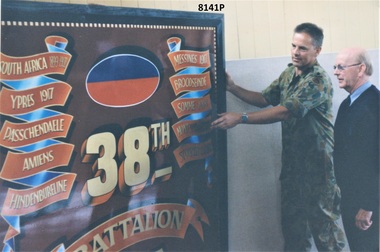 Bendigo Military Museum
Photograph - 38th BATTALION BATTLE HONOURS, C. Jan 1999
The Officer in Uniform was Major Phil Chapman OC of 15th Transport Sqd based in Bendigo in the old Passchendaele Barracks depot in Mollison Street where the Battle Honour board was held. The other in civilian clothes is Cliff Richards who was Junior Vice President of the Bendigo RSL Sub Branch at the time. The photo relates to the Board being donated to the Bendigo RSL Museum in the SMI building in January 1999. The 38th Battalion AIF was known as Bendigo's own, raised in Bendigo in 1916 for service in the Great War. Due to its size it was placed high up in what was the Billiard Room in the Museum. After a major renovation to the BDRSL Inc Club in Havilah Rd in 2013 it was then placed over the foyer front entrance. Due to another up grade it was placed in storage for awhile and is now on display in the rear foyer patrons entrance. Refer Cat No 8176.Photograph colour showing one person in military uniform and another in civilian clothes, the Officer is steadying the 38th Battalion Battle honours board.On rear in black pen, "Jan 99 C Richards Jnr Vice - Major Chapman OC 15th Tpt Platoon".brsl, smirsl, 38th -
 Bendigo Military Museum
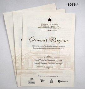
Pamphlet - SOUVENIR PROGRAM, SOLDIERS MEMORIAL INSTITUTE 2018, City of Greater Bendigo, C. Nov 2018
When the SMI was opened in Nov 1921 the Bendigo RSL Sub - Branch had occupancy from that day on. The Building became a Museum opened to the public in 1998 by the RSL. The origins of this project goes back to 2011 with a letter to the City of Greater Bendigo of the possibility of an upgrade to the SMI from the Bendigo District RSL Sub - Branch Inc. Some renovations had already taken place and some structural work. After initial talks a sub - committee of 3 persons from the RSL was elected to work with the Council along with other bodies who would be involved. Plans eventuated by 2015 and were put to the RSL for approval. From there the fund raising began from the State/Federal Govt's, RSL, the Public and Council itself. This was achieved and finally in Sept 2016 the SMI/Museum was packed up completely and the Renovations began in 2017. Souvenir program, card yellow colour folding, front page is in gold and black writing with an image of the Dome on the SMI followed by in gold, "Bendigo Soldiers Memorial Institute Revitalisation Project" then in gold, "Souvenir Program", in the centre has details re time, date, place. At the bottom are the logo's of the Federal & State Governments, RSL and City of Greater Bendigo Page 2 is titled "About the Bendigo Soldiers Memorial Institute" with a photo showing the "Hustlers Royal Reserve Mine No 2" which was on the site where the SMI now stands. Page 3 has details of the program, music, Official welcome, speakers, ribbon cutting, the ODE, Last Post, National Anthem, close of formalities and light refreshments. Page 4 has a photo of the original souvenir pamphlet used at the original opening on November 15th 1921, 97 years to the day. at the bottom, "Thankyou section to all those involved in the project""Official opening of the Bendigo Soldiers Memorial Institute Revitalisation and Military Museum 10am Thursday November 15, 2018, Lansell gardens, Pall, Mall Bendigo"brsl, smirsl, program -
 Bendigo Military Museum
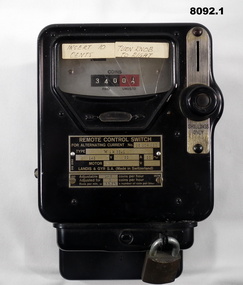
Functional object - HEATER METERS, ONE SHILLING, Landis & GYRS.A, Pre 1970
.1) This one was used in the Writing room which later became a Meeting room then finally the RSL Building & History room. it was attached to the LH side of the Fire Place and ran an old Electric Heater on the Hearth. It was used up to about 2005. .2) This one was in the Old Kitchen built on the side of the Soldiers Memorial Institute in the mid 1960's This one ran the Electric stoves used by the Womens Auxiliary of the Bendigo RSL and to make the Rum & Coffee for the ANZAC Day Dawn service. The kitchen was removed as part of the Renovations in 2016 - 18..1) Heater meter, metal construction black coating, top face has a glass section with a "usage meter" saying "coins paid, unused", metal plate under with details re numbers, maker, coins per hour, on right side slot for "Shillings only" with knob, removeable lockable tray at bottom for coin storage and removing. .2)Same style as .1) but a different glass face style metering, it has 11 circular dials with one hand, these show "Coins paid, coins unused", this one shows the round meter going around when in use. The only differance between to two shapes is at the top re fixing to a wall..1) On plate, "Remote Control Switch - for alternating switch No 26 204 020 - Type Wik 36.1 - Adjustable 1-6 coins per hour, Adjusted for 1 coin per hour" On stickers, "insert 10 cents - Turn knob to right". .2) On glass section, "230/240 revs per KWH - 1200 - Serial No 8338380 - 5 - 50". On label stuck on, "10 c equals 1/2 hour"brsl, smirsl, shilling -
 Bendigo Military Museum
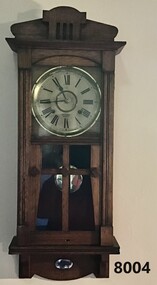
Domestic object - CLOCK, WALL PENDULUM, Gilbert Clock Co, C. 1918 - 1921
This clock was placed in what was called the "Writing Room" of the Soldiers Memorial Institute when it was opened in 1921. After the renovations to the SMI in 2016 - 18 the clock was placed back in the same position in what is now called "The Building and RSL History Room".Pendulum Wall Clock, timber frame with glass front insets in door, clock face has Roman Numerals, chimes on the hour and half hour, wind up key inside. A small silver plaque is on the front bottom space.On clock face under hands, "J.T. Knowlton & Co watch makers Bendigo". Around edge of clock face, "W.M.L Gilbert Clock Co Winsted Conn U.S.A" On small Plaque, "Presented by Pioneer Comforts Fund 15.11.1921"brsl, smirsl, domestic -
 Bendigo Military Museum
Domestic object - CLOCK, MANTLE PIECE, Gilbert Clock Co. U.S.A, possible 1918 - 1921
This clock was originally in the front Office of the Soldiers Memorial Institute Bendigo on the mantlepiece of the fireplace. Original donor or date of being placed is unknown. It was last used in 2005 by Jack Barnes OAM who wound it every day he was in the Office, he was Secretary for 43 years of the BRSL. After the renovations to the SMI in 2016 - 18 it was placed on the mantlepiece of the fireplace in what is now called "The Building and RSL History Room"Mantle Piece Clock, timber frame, hinged glass cover over the face is missing, numbers are 1 - 12 on clock face, rear door to the mechanism, a pendulum weight is taped to the inside, no wind up key.On Clock face, "Gilbert". Around clock face, "Made in Winsted Conn United States of America"brsl, smirsl, mantle -
 Bendigo Military Museum
Domestic object - CLOCK, WALL, PENDULUM, Prescott & Dawe Bendigo, possibly pre war
This clock was placed originally in what was called the "Billiard Room" of the Soldiers Memorial Institute Bendigo. There is no apparent connection to the RSL or Military service of F. Prescott. Frederick Napoli Prescott was a prominent Bendigo Optician and Jeweller at the corner of Mitchell and Hargreaves Street Bendigo. He was later in partnership with Mr C.M. Dawe trading as Prescott & Dawe. Mr Prescott died in 1913. After the renovations to the SMI 2016 - 18 this clock was placed in what is now called the "Building and RSL History Room"Pendulum wall clock timber frame with door on front, door has glass inset, each side has a glass inset, clock numbered 1 - 12, wind up key is inside, a small silver plaque is on the bottom front face.On clock face, "Prescott & Dawe". On plaque, " Presented by Mrs F Prescott in memory of F Prescott"brsl, smirsl, domestic -
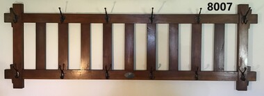 Bendigo Military Museum
Domestic object - COAT AND HAT RACK, Pioneer Comforts Fund, c. 1921
This item was placed in what was originally the "Writing Room" of the Soldiers Memorial Institute Bendigo when it was opened in 1921. After the renovations to SMI 2016 - 18 it was placed back in the same position. This room is now called the "Building and RSL History Museum.Coat and hat rack timber construction rectangular shape, has six hangars at top and six at the bottom. Each hangar holds two items, top hangars are different style to the bottom. A small silver oval plaque is central at the bottom.On the plaque, "Presented by the Pioneer Comforts Fund"brsl, smirsl, comforts -
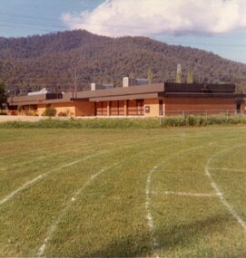 Kiewa Valley Historical Society
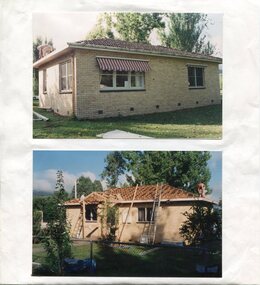
Photos - Mt Beauty Buildings in 1973. Set of 8, 1973
The shopping centre in Mt Beauty, both buildings and streetscape, have undergone significant changes since 1973. The kindergarten has undergone extensive remodelling, The Chalet has been replaced by Svarmisk Resort and Accommodation Spa. Tawonga hospital has undergone extensive renovation and is now Mt Beauty Hospital AND Kiewa Valley House. The Workman’s Club changed name to the Country Club and has since closed down. Hospital and Kiewa Valley House now occupy what is shown as a vacant lot opposite the motel which is now called Mt Beauty Motor Inn.The houses in Mt Beauty were brought in by the State Electricity Commission of Victoria when they constructed Mt Beauty Town for their workers building the Kiewa Hydro Electric Scheme. Mt Beauty is unique began as a construction town in the late 1940's.Colour photographs of various buildings in Mt Beauty taken in 1973 1. Workman’s Club 2. View over the pondage 3. Tawonga Hospital (Mt Beauty) 4. Mt Beauty Chalet 5. Mt Beauty Kindergarten 6. The Merjei Motel 7. 8 Valley Avenue 8. Shopping Centre Handwritten in ink on the back of photos 1. Workman’s Club 1973 (after the brick makeover) From the sports oval – the high school is to the right 2. A view over the pond 1973 3. Tawonga Hospital 1973 (Mt Beauty) 4. Mount Beauty Chalet 1973 5. Kindergarten 1973 6. The Merjei Motel 1973 7. Our house at 8 Valley Ave 1973, Owner after us erected the car port, let the front hedge run amok and vanquished the vegetable garden and citrus trees Dad created. 8. Shopping Centre 1973. At the end of the street is the hospital (believe it is now Mt Beauty Bush Nursing Hotel) mt beauty, workman's club, chalet, tawonga hospital -
 Kiewa Valley Historical Society
Photographs x 2 - Mount Beauty Infant Welfare Centre, February 1994
During the 1950's, Mt Beauty's population was rapidly increasing due to the post war baby boom and because there was a young workforce moving into the area due to the opportunity available for work on the construction of the Kiewa Hydro Electric Scheme. Maternal Infant Welfare Centre Sisters conducted regular check-ups on babies to ensure they were feeding well, gaining weight and reaching appropriate milestones for their age.Infants and young children in the Kiewa Valley area continue to be monitored by the Maternal Health Nurses to ensure their healthy development. The photographs are an historical record of early buildings in the Mt Beauty area, their uses and how they have changed to meet the changing needs of the community.2 x colour photographs of renovations to Mt Beauty Infant Welfare Centre. Mounted on white A4 copy paperPrinted at bottom of page underneath photos - Mt Beauty Infant Welfare Centre February 1994. Replacement of tile roof with Colourbond corrugated iron and construction of covered entry porch.mt beauty, infant welfare centre -
 Kiewa Valley Historical Society
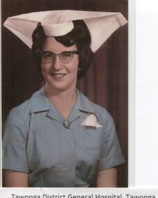
Photographs - Tawonga District General Hospital - Set of 21
In the early stages of the Kiewa Hydro-Electric Scheme the State Electricity Commission took over the financial and construction responsibility of the Tawonga District General Hospital building at a cost of 27,000 pounds. This included the removal and re-erection of the ex-military Bonegilla ward from Wodonga while in addition they carried out all the necessary building works that allowed the hospital to operate as a functional unit. The work was completed and handed over to the Hospital Committee of Management on September 1, 1949. Local residents raised 3,400 pounds through fund raising. The balance was met by the SEC and the Hospital and Charities Commission. The initial project was to provide for a basic temporary hospital which was later to include an Operating Theatre, Offices, Store, Mortuary and a Nurse’s Home, until the establishment of a permanent medical premises. Following the opening, 455 patients were admitted to the Tawonga District General Hospital and 254 operations were performed in the first year. The hospital relocated to Mount Beauty in the former SEC administration offices located in the town centre. Official opening of the 18 bed Tawonga District General Hospital on April 29 in 1961. Alpine Health CEO Mr Lyndon Seys oversaw the opening of the new Mount Beauty Hospital in November 2001 alongside Board of Management President Mr Andrew Randell, other board members and politicians. The Kiewa Hydro-Electric Scheme the State Electricity Commission played a pivotal part in the planning and initial funding of the Tawonga District General Hospital, with a view to providing medical support for its many workers on the Hydro scheme. Later, spouse and family members of workers were also able to access medical assistance The hospital was originally located in Tawonga away from the majority of the patients as the Hospital and Charities Board was not prepared to have it within the SEC controlled area. It was not until the gate at Tawonga South was taken down that the hospital was moved to the main centre of population at Mount Beauty. 1. Early nurses uniform; 2. Hospital Opening Ceremony; 3-7. Nursing Staff; 8. Delivery Room; 9. Mens Ward; 10.Enclosed Veranda; 11. Main Ward; 12-13. Kitchen; 14. Opening Ceremony 1949; 15.Original Hospital at Tawonga; 16-18. Relocated Hospital at Mt Beauty; 19. Rear of hospital and Matron’s quarters; 20. Hospital and Kiewa Valley House; 21. Renovated Hospital in 20001.Tawonga District General Hospital Tawonga; 2. Kiewa construction engineer Mr HHC Williams speaking at the opening of the hospital. Health Minister the Hon CP Gartside performed the official opening. L to R: TH Mitchell MLA; Manager of the hospital Mr RH Kronberg (obscured) Hon CP Gartside; CL McVilley; LT Knevitt; Matron AI Tarnish & W Sealey: 4. Dedicated Nursing Staff; 5. Nurse Campbell (nee Reid); 6. Sister Seager 1955 (nee Janice Burnett. First District Nurse; 7. L to R: Sister F Rosengrove; Sister J Griffiths; Matron AI Tarnish; Nurse D Satori; Nurse D Tregonning; Sister E Hill & Sister S O’Shannessy; 8. In the early years Tawonga District General Hospital had the second highest birth rate in Australia; 9. The men’s ward catered for men only in the early years of the hospitals operation; 10. The enclosed verandah at the original Tawonga District General Hospital allowed for an additional 10 beds; 11. Tawonga District General Hospital, Tawonga Main Ward. Ward ready and waiting for patients at Tawonga Hospital. Complete with lovely vases of flowers for every bed. Nice touch by the nurses; 12. Kitchen of Tawonga District General Hospital, Mt Beauty. The hospital kitchen provided meals for patients and a 3 course dinner for Meals on Wheels. In 1977, 11,795 meals were produced at an average cost of $2.60 per meal; 13. Tawonga District General Hospital, Tawonga. Kitchen. Kitchen staff employed in the old Tawonga District General Hospital 1949-1961; 14. The official opening ceremony of the Tawonga District General Hospital, 1949. The official ceremony was attended by a large number of residents and Tawonga District General Hospital was open for public inspection; 15. Original Tawonga District General Hospital transported form Bonegilla began operations in 1949; 16. In 1961, the Tawonga District General Hospital relocated to take a central position in the town of Mt Beauty in the former SEC Administration building; 19. The rear of the Tawonga District General Hospital and Matron’s house seen from Holland St, Mt Beauty during a snow storm in the mid 1960’s; 21. Tawonga District General Hospital & Kiewa Valley House, 2000. tawonga district hospital, mt beauty hospital, medical, health care, s.e.c. -
 Warrnambool and District Historical Society Inc.
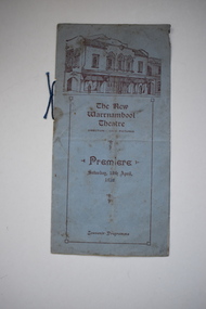
Document, The New Warrnambool Theatre, 1930
This is an original programme issued when the Warrnambool Theatre was opened in 1930 in Kepler Street. The programme for the premiere of the picture theatre included an ‘all talking’ feature, ‘Hollywood Revue’ and all of the 1150 seats were filled. The building replaced the Palais de Danse and the Mansions Theatre, part of the Hotel Mansions destroyed by fire in 1929. The architects for the new theatre were Bohringer, Taylor and Johnson in association with R.A. Le Poer Terry and H. Mervyn Thompson. The Warrnambool Theatre, one of six cinemas in Victoria built in the Spanish Mission style, was renamed the Capitol Theatre in 1935. In 1994 the Capitol Theatre interior was renovated and the rare original design features (only 3 remaining in Victoria at the time) were covered up.This programme has considerable interest as it concerns the opening of the Warrnambool Theatre (later the Capitol Theatre) in Warrnambool. This is a significant building in Warrnambool because of its architecture.This is a programme with a cover and one insert sheet folded into two. The cover is blue with red printing and has an image of the Warrnambool Picture Theatre on the front. The insert pages are buff-coloured with red printing and several advertisements. A blue piece of string holds the programme together. ‘The New Warrnambool Theatre. Direction Civic Pictures’ ‘Premiere Saturday 12th April 1930 Souvenir Programme’ capitol theatre warrnambool -
 Port of Echuca
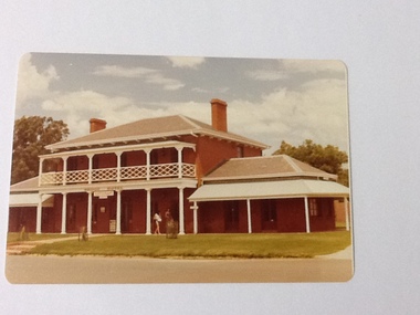
Colour Photograph, Approx.1979
The Bridge Hotel was built by Henry Hopwood, founder of Echuca. The building was in disrepair until it was bought by the Port of Echuca and renovated to be turned into part of the Port of Echuca tourist exhibits and was leased out to be run as a restaurant.The Bridge Hotel is of historical and social significance to Echuca as it was built be Echuca's founder Henry Hopwood. The hotel was situated between the 2 rivers, Murray and Campaspe, where Hopwood ran his punt business, charging people and animals to cross the rivers. The hotel accommodated a variety of paying guest from wealthy squatters to salesmen and general workers. The building was purchased by the Port of Echuca to be part of the tourist attraction. It was extensively renovated to bring it back to its former glory. The Bridge hotel played an important role in the TV series "All the Rivers Run". Colour photograph of the Bridge Hotel, Echuca, after restorations (c.1979)On front of building : Bridge Hotel / Restaurant Printed on reverse:"This paper manufactured by Kodak"bridge hotel, echuca, port of echuca, echuca, victoria -history, henry hopwood -
 Port of Echuca
Photograph - Black and white photograph, Late 1970s
Relates to a series of 5 photos:P000094-P000098 of the front of the Bridge Hotel on the corner of Murray esplanade and Hopwood gardens. These photos, taken about 1976, were before the Port Restoration Scheme renovated the hotel. The Bridge Hotel was built by Henry Hopwood in 1858. This and the Bond Store were Echuca's first 2 brick buildings. Named from Hopwood's nearby pontoon bridge. The building was bought be The Council in 1970. Restored and reopened in 1975.The Bridge Hotel is an important part of Echuca's settlement and development. It was originally built by Henry Hopwood, the European founder of Echuca, in 1859. Hopwood built the hotel to provide accommodation to people using his punts across the Campaspe and Murray rivers that area central to the landscape of the Port. The hotel was situated on the land between both rivers and punts and provided for a variety of levels of accommodation from grand rooms to very basic rooms. At the time of the photos the hotel was 120 years old and became an important part of the Port of Echuca tourism. Black and white photograph of the Bridge Hotel , showing western wing before restoration.Stamped on the reverse "Gazemore Studio, D. G. Gay, 18 Frances Street Echuca 3625.bridge hotel, echcua, port restoration scheme, bridge hotel restoration, echuca -
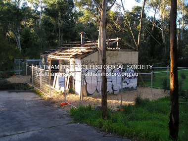 Eltham District Historical Society Inc
Photograph, Fay Bridge, Warrandyte cool store, 9 September 2019
Remains of the old Warrandyte Dairy — Originally constructed to store milk for delivery from Mapleoak Dairies, delivered by the Bellinger family, up until the early 1970s. The Warrandyte Dairy closed in 1987 before the land and building was purchased by Melbourne Water in 1988 to reduce flood risk to the community and preserve riverside land from development on the site which sits on the Yarra River flood plain. In 2017, through a partnership with Manningham City Council, Warrandyte Historical Society and the Warrandyte Community Association, Melbourne Water renovated the 73-year-old site and installed interpretive signs detailing its history for the community.2019-09-09, fay bridge collection, warrandyte cool store, warrandyte dairy -
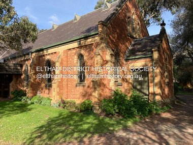 Eltham District Historical Society Inc
Photograph, Jim Connor, Eltham - Montmorency Uniting Church, 810 Main Rd, Eltham, 10 July 2023
Located on the corner of Main Road and John Street, the church first served the community as the Eltham Wesleyan Church since 1881. It became the Eltham Methodist Church in 1902, the year it united with the Primitive Methodists. Eltham Wesleyans first worshipped together in the home of William and Mary Crozier, on 24 acres bounded by Mount Pleasant Road and Pitt Street. From there they moved to a slab and bark hut in 1855 (this later served as the first school run by David Clark prior to the building of a new school in Dalton Street) and the members then built a chapel in 1858 on Lot 20, Henry Street (later to become the Rechabite Hall and Eltham Public Hall). The present church on John Street was designed by architects Crouch and Wilson in the Early English Gothic style with biochrome brick window frames, buttress heads and pinnacle. Church member George Stebbing built the church, the foundations were constructed with stone from the walls of the first Eltham State Primary School (No. 209) building which collapsed in 1874 and were purchased by Robert David Taylor. Stebbing was also responsible for building St Margaret’s Church and Shillinglaw Cottage. The Roll of Honour, which presently hangs in the church hall (which also doubles as the Opportunity Shop) lists 27 members of the congregation who served in the First World War, 11 of whom never returned. The red-brick Church Hall was opened in 1931 and in 1971 further additions linked the hall and church, including a foyer, vestry, meeting room and toilets reflecting the Eltham style of that time with its simplicity, extensive clear glass, reused baked clay-bricks from the 1881 church, heavy ceiling beams and compressed straw ceiling. On June 26, 1977, the church became part of the new Uniting Church in Australia consisting of the former Methodist and Congregational and most of the Presbyterian Churches. Following of declining numbers of worshippers, the church merged with the Montmorency Uniting Church on June 23, 1996. In 2023 the Uniting church approved a plan to renovate the church. It is understood that the historic church and the hall will be retained, and the building added in 1971 is to be demolished, to make way for a new purpose-built Opportunity shop. The proposed areas to be demolished include the current foyer, toilets, crèche, etc, including the area between the hall and the former RSL. Works are expected to commence mid to late July 2023. The Society was invited by a church member to take photographs of these areas to document them prior to demolition works commencing. Ref: “Nillumbik Now and Then” by Marguerite Marshall (2008)jim connor collection, 2023-07-10, eltham-montmorency uniting church, john street, methodist church, opportunity shop, uniting church, uniting church hall -
 Eltham District Historical Society Inc
Document - Sales Brochure, Dallas Price Homes Pty Ltd, Eltham Hub: A Unique New Entry To Eltham's Town Centre; the facts about this multi purpose development, 1996
Produced by Contour Consultants Australia Pty Ltd on behalf of Dallas Price Homes Pty Ltd as part of the planning process for redevelopment of the former Eltham Shire Office site at 895 Main Road. In 1963 the Shire of Eltham purchased the Shillinglaw property of approximately 2 acres in Main Road, Eltham for the widening of Main Road and as a site for new Council offices. This land, which contained the Shillinglaw Cottage (c1878-80), was the remaining section of the Shillinglaw family holding that originally comprised 30 acres, being Lot 90 of Holloway's 1851 subdivision. Eltham Council intended to demolish this cottage, but through extensive community action it was saved, funds were raised, and it was relocated to the current site adjacent to the Eltham Library. The new Eltham Shire Offices opened in 1965 were designed to ensure retention of the three Italian Cypress trees that were located outside the Shillinglaw Cottage. In 1971 the building was extended at the southern end to provide additional space, including for the Eltham Library and Council's Engineering Department. Renovations were undertaken to the offices during 1987. The Victorian State Government commenced to restructure local government in 1994, which resulted in the establishment of the Shire of Nillumbik and the cessation of the Shire of Eltham. This new Nillumbik Shire Council was headed by government appointed commissioners, who decided in 1995 to put the former Eltham Shire offices on the market. Eventually in June 1996 the property was sold for $1.1 million and the building was subsequently demolished. A planning application for the site was then submitted to Nillumbik Shire Council in September 1996 for construction of a 24-hour service station, convenience store, cafe/takeaway food premises, a retail facility and community facility. There were many objections to this proposed development and in controversial circumstances a planning permit was granted by the Nillumbik Shire Council commissioners. After protracted actions involving a planning panel and a planning advisory committee, established by the Minister for Local Government, the proposal was eventually rejected as not satisfying the requirements of the planning scheme. In December 1997 the purchaser withdrew from the contract of sale, just prior to Council announcing a withdrawal from the contract. While there have been a number of possible development proposals considered by subsequent Nillumbik Shire Councils, this site has remained vacant since July 1996. TIMELINE (Prepared by Jim Connor, Eltham District Historical Society- March 2018- Based on press, council and personal records) June 1996 - Eltham Shire offices sold to Dallas Price Homes for $1.1 million. July 1996 - Shire office building demolished against community's wishes. Council claimed building riddled with asbestos. September 1996 - Planning application submitted to Nillumbik Shire Council to construct on the site a 24 hours Shell service station, convenience store, Hungry Jacks café/takeaway food premises, a retail facility and community facility. 213 objections and petition of over 1400 signatures received. Minister for Planning and Local Government orders an independent investigation into valuation and sale. 9 October 1996 - Permit granted by Nillumbik Shire Council commissioners, in controversial circumstances. A Planning Special Committee consisting of 3 commissioners and 3 community representatives considered 32 community objections. One commissioner declared a potential conflict of interest so only 2 commissioners were able to vote. After hearing all objections, the community representatives moved a foreshadowed motion to refuse a permit. The commissioners then closed the meeting, formerly opened a council meeting (for about a minute) and approved the application. October 1996 - Community members appealed planning decision to Administrative Appeals Tribunal. November 1996 -Minister for Planning and Local Government Robert McClelland calls appeal in and directs MT to refer this 'major policy issue' to the Governor in Council. February 1997 - Planning panel (Dimity Reed and Margaret Pitt) established to consider submissions. March 1997 - New council elected with five councillors. April 1997 - Three of the five new councillors vote to fight Commissioner's decision to grant a permit. April 1997 - Planning panel (Dimity Reed and Margaret Pitt) conducts hearings at Nillumbik Shire offices. June 1997 -Planning panel rejected Dallas Price Homes proposal as being 'totally inappropriate' for the site and recommends the site be rezoned for 'public purposes'. July 1997 - Dallas Price Homes threatened to sue Council and individual councillors. October 1997 - Report released of an Advisory Committee (Paul Jerome) established by the Minister for Planning and Local Government. Committee considered Dallas Price Homes proposal and an alternative concept plan proposal by Council for a gallery, workshop, offices and cinema community-based development. Advisory Committee recommended Dallas Price Homes proposal be rejected as not satisfying the requirements of the planning scheme and recommended further testing of the financial viability of Council's proposal. December 1997 - Dallas Price Homes withdrew from the contract of sale, just prior to Council announcing a withdrawal from the contract, which expired on 28th November and was not renewed by either side, after previously being extended twice pending a decision by the Minister. Council had to pay developer $58,000 for demolition costs. February 1998 - Dallas Price Homes application rejected by Planning and Local Government Minister. October 1998 - Nillumbik Councillors suspended and an Administrator appointed (until March 1999). The demolition of the former Shire of Eltham offices and proposed sale and development driven by the Commissioners for Nillumbik Shire Council brought the community together in substantial protest at the infrigement of ratepayers democratic say in local government and ciommunity assets combined with protests about inappropraite development of Eltham's Gateway. This issue led to the formation of the Eltham Community Action Group which still operates strongly today (2023) on behalf of the community to ensure appropriate development within the community.895 main road, commissioners, dallas price homes, development application, eltham hub, hungry jacks, nillumbik shire council, re-zoning, shell service station, town planning, eltham gateway, eltham gateway action group, eltham shire offices, shillinglaw cottage, shillinglaw farm, shillinglaw trees, jim connor collection