Showing 164 items matching "right to occupy"
-
 Phillip Island and District Historical Society Inc.
Photograph, 1978/9
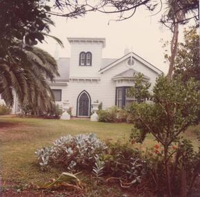
Woolamai House was built in approx 1869 on part of Capt Cleeland's property which covered most of the eastern end of Phillip Island. He maintained the Beacon Light on Woolamai Point close to his house. Owned and occupied by family since 1869.Photograph coloured. Front aspect of house showing front door and bay window on right. Timber turret above - garden in front. Construction built for Capt. John Cleeland approx 1869. Known as Woolamai House.local history, photographs, buildings - historical, coloured photograph, john cook, woolamai house, cleeland family history -
 Phillip Island and District Historical Society Inc.
Photograph, 1978/9
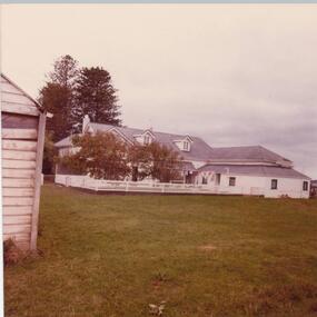
Woolamai House was built in approx 1869 on part of Capt Cleeland's property which covered most of the eastern end of Phillip Island. He maintained the Beacon Light on Woolamai Point close to his house. Owned and occupied by family since 1869.Coloured photograph - back view of the timber house, painted white with grey roof. Two turret rooms. White painted fence. Lawn in foreground. ?Fernery on right.local history, photographs, buildings - historical, woolamai house, coloured photograph, john cook, cleeland family history -
 Glenelg Shire Council Cultural Collection
Souvenir - Tea Towel - Maretimo, Portland, n.d
From the National Trust register: Statement of Significance Maretimo, a 22 room single storey Australian Colonial Georgian style mansion set on a prominent bluff overlooking Portland harbour, was erected c. 1854 for John Norman McLeod. The design of Maretimo, which is constructed of basalt ashlar with fine-axed parapet entablature, delicate open timber work verandah and Regency interior, has been tenuously attributed to Adelaide architect James Barrow. Maretimo is rivalled only by the stylistically similar Henty residence, Burwsood of 1853 by James Barrow, as perhaps the finest Australian Colonial Georgian style residence erected within the first twenty years of settlement in Victoria. The residence, which was occupied for twenty years by distinguished English-born gentleman parliamentarian, pastoralist and former Van Deimen's Land settler, J H McLeod, is now notable for the disciplined facade and elegantly crafted interiors. Maretimo has been meticulously maintained and is presented in near perfect original condition. The interiors have been sensitively enhanced and redecorated.Linen souvenir tea towel 'Maretimo'. Green and black on cream. 'MARETIMO' at top, front view of Maretimo beneath, then map of locaion, then view from air. 'HISTORIC HOME PORTLAND, VICTORIA' beneath 'Pure Linen', bottom right.historic building, historic homestead, maretimo, henty, souvenir -
 Halls Gap & Grampians Historical Society
Photograph - B/W
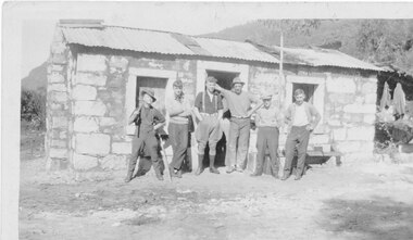
It is believed that the three stone cottages in the area were built c.1930 by Italian stonemasons. This cottage is a single room with open fireplace at one end. A hole was dug in the floor inside which a small drum was sunk and covered by a wooden lid. It served as a cool box for the storage of perishable food. It is not known when the cottage was last occupied but during the 1970s the drum was removed and the pit filled in for safety reasons. Photo shows 6 men standing in front of stone cottage at Heatherlie (Mt Difficult) quarry. Cottage made from sawnand off-cuts of stone with stone window frames and door lintel. Rough bush-pole awning at right hand end of cottage.houses, mt difficult quarry -
 Halls Gap & Grampians Historical Society
Photograph - B/W, 1920-1930
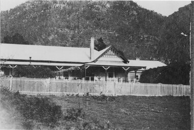
During the period 1924-1967 Bellfield operated as a licenced hotel. It became a popular destination for couples on their honeymoon The hotel was razed to the ground by fire in 1967 and was never rebuilt. The Grampians Motel now occupies the sitephotograph shows right hand section of Bellfield Hotel with woman on verandah to the right of bare tree Wonderland Range behindcopy done by AGFA Dec 99accommodation, hotels, bellfield -
 Eltham District Historical Society Inc
Photograph, The Weekly Times, Opening of the Heidelberg-Eltham Railway Line, 6 June 1902, 1902
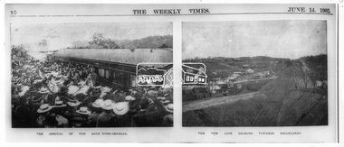
Reproduced from "The Weekly Times", 14th June 1902, page 10. 06 Jun 1902 Cross Reference Photo No.(s): 602, 604 Source: La Trobe Library and National Library, Canberra THE HEIDELBERG TO ELTHAM RAILWAY. OPENING CEREMONY. The opening of the railway line from Heidelberg to Eltham took place on the 6th inst. The special train, containing a large number of members of Parliament, including Mr Trenwith, the Minister for Railways, left Prince's Bridge at half-past eleven, and arrived at Eltham at twenty minutes past twelve. The party was accompanied by Mr Fitzpatrick, Acting Commissioner for Railways; Mr Lockhead, the Traffic Manager; and Mr Norman, Engineer for Existing Lines. On arrival, the visitors were entertained at a banquet in the marquee, of which a photograph is given, erected close to the railway station. Mr E. H. Cameron, M.L.A., the member for the district, occupied the chair, and, seated on his right, was Mr Mason, the Speaker of the Legislative Assembly, and on his left the Minister of Rail-ways. After the banquet His Excellency the Governor-General arrived, and was received and welcomed by Mr Cameron, the local State school children singing the National Anthem. The Governor-General, in declaring the line open, said that he felt highly honored at being asked to perform the opening ceremony, and he trusted that the railway would be a source of great convenience to the inhabitants of the district. He was sorry to say that this would be the last opportunity he would have of seeing them. It cost him a great deal to leave them. (Hear, hear.) He had a great many friends amongst all sections of the community, and he could hardly bear to trust himself to speak about leaving them. (Hear, hear.) He was sorry Lady Hopetoun was on the high seas, and unable to accompany him that day. Mr Cameron thanked his Excellency for performing the opening ceremony, and hoped the trip home would have the effect of restoring His Excellency to good health again. In replying. Lord Hopetoun thanked them sincerely for the cordial vote of thanks. He hoped Providence would shower her blessings over them, and that they would have a series of good seasons. He would always keep a warm corner in his heart for the people of Victoria. (Loud cheers.) THE COUNTRY. In our illustrations, views are given of a couple of sections of the new line, and glimpses of the surrounding country are shown. The line is eight miles in length, and cost £51,000 in construction. Eltham, which is the terminus, possesses many of the features that go to make a favorite holiday resort. It is a quiet picturesque little hamlet, snugly ensconced on the slope of one of many sombre-tinted hills by which it is sur-rounded. Even when viewed under ad-verse conditions one could not fail to be-impressed with the natural, rugged beauty of the place. It is situated about sixteen miles from Melbourne, and the line takes a circuitous course through a continuation of pretty undulating country. At intervals on the slopes of the surrounding green-mantled hills, patches of brown, freshly tilled soil indicate that for all its serene reposeful-ness Eltham possesses its phases of industrial life as well. Looking down into this valley from the main road which skirts the slope of a hill, distant something less than a quarter of a mile from the railway station is one of the prettiest pieces of scenery in the district. Verdure-clad hills ascend on all sides, whilst beneath stretches a broad expanse of carpet-like green sward, dotted here and there with picturesque homesteads, each with its patches of tilled soil. In the township itself the dwelling-houses are comparatively few, the larger portion of the inhabitants residing in the scattered homesteads. Eltham is as yet only in its youth, but energetic and un-tiring public men can effect wonders in a community's prosperity, and Eltham, whatever other real or imaginary advantages it may lay claim to, certainly possesses this one. The railway is the result of their endeavor. 1902 'THE HEIDELBERG TO ELTHAM RAILWAY.', Weekly Times (Melbourne, Vic. : 1869 - 1954), 14 June, p. 14. , viewed 26 Sep 2018, http://nla.gov.au/nla.news-article221230719This photo forms part of a collection of photographs gathered by the Shire of Eltham for their centenary project book,"Pioneers and Painters: 100 years of the Shire of Eltham" by Alan Marshall (1971). The collection of over 500 images is held in partnership between Eltham District Historical Society and Yarra Plenty Regional Library (Eltham Library) and is now formally known as the 'The Shire of Eltham Pioneers Photograph Collection.' It is significant in being the first community sourced collection representing the places and people of the Shire's first one hundred years.Digital image 35mm B&W negativesepp, shire of eltham pioneers photograph collection, eltham, heidelberg-eltham railway extension -
 Eltham District Historical Society Inc
Photograph, Opening of the Railway Line; The arrival of the Governor-General, 6 June, 1902, 1902
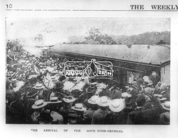
Published: The opening of the railway line by His Excellency The Governor General, The Weekly Times, June 14, 1902, p10. Governor General was John Hope, Earl of Hopetoun THE HEIDELBERG TO ELTHAM RAILWAY. OPENING CEREMONY. The opening of the railway line from Heidelberg to Eltham took place on the 6th inst. The special train, containing a large number of members of Parliament, including Mr Trenwith, the Minister for Railways, left Prince's Bridge at half-past eleven, and arrived at Eltham at twenty minutes past twelve. The party was accompanied by Mr Fitzpatrick, Acting Commissioner for Railways; Mr Lockhead, the Traffic Manager; and Mr Norman, Engineer for Existing Lines. On arrival, the visitors were entertained at a banquet in the marquee, of which a photograph is given, erected close to the railway station. Mr E. H. Cameron, M.L.A., the member for the district, occupied the chair, and, seated on his right, was Mr Mason, the Speaker of the Legislative Assembly, and on his left the Minister of Rail-ways. After the banquet His Excellency the Governor-General arrived, and was received and welcomed by Mr Cameron, the local State school children singing the National Anthem. The Governor-General, in declaring the line open, said that he felt highly honored at being asked to perform the opening ceremony, and he trusted that the railway would be a source of great convenience to the inhabitants of the district. He was sorry to say that this would be the last opportunity he would have of seeing them. It cost him a great deal to leave them. (Hear, hear.) He had a great many friends amongst all sections of the community, and he could hardly bear to trust himself to speak about leaving them. (Hear, hear.) He was sorry Lady Hopetoun was on the high seas, and unable to accompany him that day. Mr Cameron thanked his Excellency for performing the opening ceremony, and hoped the trip home would have the effect of restoring His Excellency to good health again. In replying. Lord Hopetoun thanked them sincerely for the cordial vote of thanks. He hoped Providence would shower her blessings over them, and that they would have a series of good seasons. He would always keep a warm corner in his heart for the people of Victoria. (Loud cheers.) THE COUNTRY. In our illustrations, views are given of a couple of sections of the new line, and glimpses of the surrounding country are shown. The line is eight miles in length, and cost £51,000 in construction. Eltham, which is the terminus, possesses many of the features that go to make a favorite holiday resort. It is a quiet picturesque little hamlet, snugly ensconced on the slope of one of many sombre-tinted hills by which it is sur-rounded. Even when viewed under ad-verse conditions one could not fail to be-impressed with the natural, rugged beauty of the place. It is situated about sixteen miles from Melbourne, and the line takes a circuitous course through a continuation of pretty undulating country. At intervals on the slopes of the surrounding green-mantled hills, patches of brown, freshly tilled soil indicate that for all its serene reposeful-ness Eltham possesses its phases of industrial life as well. Looking down into this valley from the main road which skirts the slope of a hill, distant something less than a quarter of a mile from the railway station is one of the prettiest pieces of scenery in the district. Verdure-clad hills ascend on all sides, whilst beneath stretches a broad expanse of carpet-like green sward, dotted here and there with picturesque homesteads, each with its patches of tilled soil. In the township itself the dwelling-houses are comparatively few, the larger portion of the inhabitants residing in the scattered homesteads. Eltham is as yet only in its youth, but energetic and un-tiring public men can effect wonders in a community's prosperity, and Eltham, whatever other real or imaginary advantages it may lay claim to, certainly possesses this one. The railway is the result of their endeavor. 1902 'THE HEIDELBERG TO ELTHAM RAILWAY.', Weekly Times (Melbourne, Vic. : 1869 - 1954), 14 June, p. 14. , viewed 26 Sep 2018, http://nla.gov.au/nla.news-article221230719This photo forms part of a collection of photographs gathered by the Shire of Eltham for their centenary project book,"Pioneers and Painters: 100 years of the Shire of Eltham" by Alan Marshall (1971). The collection of over 500 images is held in partnership between Eltham District Historical Society and Yarra Plenty Regional Library (Eltham Library) and is now formally known as the 'The Shire of Eltham Pioneers Photograph Collection.' It is significant in being the first community sourced collection representing the places and people of the Shire's first one hundred years.Digital image Negative black and white film 120 6x9 format 2 stripsAgfa APX 100sepp, shire of eltham pioneers photograph collection, eltham, heidelberg-eltham railway extension, earl of hopetoun, john hope, opening day, railway line construction -
 Kiewa Valley Historical Society
Stocks for Riding Boots, Late 1800's to early 1900's
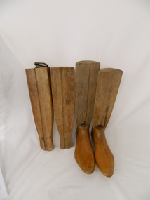
These wooden trees for riding stocks are a concept that was brought to early colonial days from "mother" England. Gentle folk of wealth and status used these trees from early 1800's to keep and maintain their riding boots in their correct form. This form of maintaining the tall riding boot structure was maintained in Australia by the rural "elite" both on cattle properties and smaller cattle stations in the early 1900's. Good riding boots were a status symbol in rural and outback Australia. The riding stocks "wooden trees" are very significant in the Kiewa Valley because they were used by members of some of the original grazing cattle families to settle there. Both cattle and sheep properties occupied large areas of the Kiewa Valley and they also herded their flock and herd on the Bogong High Plains region. These stocks and boots were worn by Fred Roper whose great grand daughter donated them to KVHS. Therefore these boots and stocks would date from 1880's to 1920's and are a good representation of the style of boots worn during this period. This pair of wooden stocks for riding boots trees has been manufactured to a very high standard. Each of the four boot tree parts fit snugly together and maintain their form, and that of the boot that they occupy. The groove channels and foot forms (tongue and groove) are exact and once snapped together become very solid. There is a brass ring, attached by a small brass "peg" on each of the thin "sliding" middle uprights. See KVHS 0177 - Riding boots.On top "L" (for left boot), "R" (for right boot)horse. country. leather. gaiters. high plains. grazing. cattlemen. laces. studs. stocks. roper family. bogong high plains. -
 Eltham District Historical Society Inc
Photograph, George W. Bell, Birch Cottage, Yarra Glen Road, Smiths Gully, Aug 1969, Aug 1969
EDHS Newsletter No. 182, September 2008 In the late 1970s when our Society was the Shire of Eltham Historical Society, an offer was made to the Society regarding use of an old cottage at Christmas Hills. For various reasons the offer ultimately lapsed The cottage sat beside Watsons Creek just outside the then Shire of Eltham but following municipal restructuring it now lies within the Shire of Nillumbik. At that time some research on the cottage was carried out for the Society by Keith Chappel as part of a larger research project that he was doing. Keith's notes were taken from Lands Department records and showed that house is the subject of a permissive occupancy of Crown land comprising the creek reserve. In 1903 a Miners Right of one acre in area was granted to Edwin Samuel Birch. In 1907 Birch applied to purchase this land but was unable to because it was part of the creek reserve. The documents show that the house existed at that time. Birch died in 1932 and his daughter Honor Mary Birch was granted a permit to occupy the residence. The future of the cottage remains precarious because of its location on Crown land. In 2007 the Andrew Ross Museum began a campaign to ensure that it is preserved. It included a video presentation on the history of the cottage under the title of "This Old House- Birch Cottage". Black and white photographWilliams Cottage Panton Hill 1969 Not to be reproduced without permission G.W. Bell Photographer Elthamhouses, cottage, early settlers, yarra glen road, smiths gully, williams cottage, watsons creek, christmas hills, birch cottage, edwin samuel birch, honor mary birch -
 Eltham District Historical Society Inc
Photograph, George W. Bell, Detail, Kitchen, Birch Cottage, Yarra Glen Road, Smiths Gully, Aug 1969, Aug 1969
EDHS Newsletter No. 182, September 2008 In the late 1970s when our Society was the Shire of Eltham Historical Society, an offer was made to the Society regarding use of an old cottage at Christmas Hills. For various reasons the offer ultimately lapsed The cottage sat beside Watsons Creek just outside the then Shire of Eltham but following municipal restructuring it now lies within the Shire of Nillumbik. At that time some research on the cottage was carried out for the Society by Keith Chappel as part of a larger research project that he was doing. Keith's notes were taken from Lands Department records and showed that house is the subject of a permissive occupancy of Crown land comprising the creek reserve. In 1903 a Miners Right of one acre in area was granted to Edwin Samuel Birch. In 1907 Birch applied to purchase this land but was unable to because it was part of the creek reserve. The documents show that the house existed at that time. Birch died in 1932 and his daughter Honor Mary Birch was granted a permit to occupy the residence. The future of the cottage remains precarious because of its location on Crown land. In 2007 the Andrew Ross Museum began a campaign to ensure that it is preserved. It included a video presentation on the history of the cottage under the title of "This Old House- Birch Cottage". Black and white photographWilliams Cottage Panton Hill 1969 Not to be reproduced without permission G.W. Bell Photographer Elthamhouses, cottage, early settlers, yarra glen road, smiths gully, williams cottage, watsons creek, christmas hills, birch cottage, edwin samuel birch, honor mary birch -
 Eltham District Historical Society Inc
Photograph, George W. Bell, Detail, Cottage Entrance, Birch Cottage, Yarra Glen Road, Smiths Gully, Aug 1969, Aug 1969
EDHS Newsletter No. 182, September 2008 In the late 1970s when our Society was the Shire of Eltham Historical Society, an offer was made to the Society regarding use of an old cottage at Christmas Hills. For various reasons the offer ultimately lapsed The cottage sat beside Watsons Creek just outside the then Shire of Eltham but following municipal restructuring it now lies within the Shire of Nillumbik. At that time some research on the cottage was carried out for the Society by Keith Chappel as part of a larger research project that he was doing. Keith's notes were taken from Lands Department records and showed that house is the subject of a permissive occupancy of Crown land comprising the creek reserve. In 1903 a Miners Right of one acre in area was granted to Edwin Samuel Birch. In 1907 Birch applied to purchase this land but was unable to because it was part of the creek reserve. The documents show that the house existed at that time. Birch died in 1932 and his daughter Honor Mary Birch was granted a permit to occupy the residence. The future of the cottage remains precarious because of its location on Crown land. In 2007 the Andrew Ross Museum began a campaign to ensure that it is preserved. It included a video presentation on the history of the cottage under the title of "This Old House- Birch Cottage". Black and white photographDetail Cottage Entrance Williams Cottage Yarra Glen Rd Panton Hill Aug 1969 Photo - G.W.Bhouses, cottage, early settlers, yarra glen road, smiths gully, williams cottage, watsons creek, christmas hills, birch cottage, edwin samuel birch, honor mary birch -
 Eltham District Historical Society Inc
Photograph, George W. Bell, Detail, Front Wall, Birch Cottage, Yarra Glen Road, Smiths Gully, Aug 1969, Aug 1969
EDHS Newsletter No. 182, September 2008 In the late 1970s when our Society was the Shire of Eltham Historical Society, an offer was made to the Society regarding use of an old cottage at Christmas Hills. For various reasons the offer ultimately lapsed The cottage sat beside Watsons Creek just outside the then Shire of Eltham but following municipal restructuring it now lies within the Shire of Nillumbik. At that time some research on the cottage was carried out for the Society by Keith Chappel as part of a larger research project that he was doing. Keith's notes were taken from Lands Department records and showed that house is the subject of a permissive occupancy of Crown land comprising the creek reserve. In 1903 a Miners Right of one acre in area was granted to Edwin Samuel Birch. In 1907 Birch applied to purchase this land but was unable to because it was part of the creek reserve. The documents show that the house existed at that time. Birch died in 1932 and his daughter Honor Mary Birch was granted a permit to occupy the residence. The future of the cottage remains precarious because of its location on Crown land. In 2007 the Andrew Ross Museum began a campaign to ensure that it is preserved. It included a video presentation on the history of the cottage under the title of "This Old House- Birch Cottage". Black and white photographDetail of Front Wall Williams Cottage Yarra Glen Rd Panton Hill Aug 1969 Photo - G.W.Bhouses, cottage, early settlers, yarra glen road, smiths gully, williams cottage, watsons creek, christmas hills, birch cottage, edwin samuel birch, honor mary birch -
 Eltham District Historical Society Inc
Photograph, George W. Bell, Detail, Shed Wall, Birch Cottage, Yarra Glen Road, Smiths Gully, Aug 1969, Aug 1969
EDHS Newsletter No. 182, September 2008 In the late 1970s when our Society was the Shire of Eltham Historical Society, an offer was made to the Society regarding use of an old cottage at Christmas Hills. For various reasons the offer ultimately lapsed The cottage sat beside Watsons Creek just outside the then Shire of Eltham but following municipal restructuring it now lies within the Shire of Nillumbik. At that time some research on the cottage was carried out for the Society by Keith Chappel as part of a larger research project that he was doing. Keith's notes were taken from Lands Department records and showed that house is the subject of a permissive occupancy of Crown land comprising the creek reserve. In 1903 a Miners Right of one acre in area was granted to Edwin Samuel Birch. In 1907 Birch applied to purchase this land but was unable to because it was part of the creek reserve. The documents show that the house existed at that time. Birch died in 1932 and his daughter Honor Mary Birch was granted a permit to occupy the residence. The future of the cottage remains precarious because of its location on Crown land. In 2007 the Andrew Ross Museum began a campaign to ensure that it is preserved. It included a video presentation on the history of the cottage under the title of "This Old House- Birch Cottage". Black and white photographDetail of Shed Wall Williams Cottage Yarra Glen Rd Panton Hill Aug 1969 Photo - G.W.Bhouses, cottage, early settlers, yarra glen road, smiths gully, williams cottage, watsons creek, christmas hills, birch cottage, edwin samuel birch, honor mary birch -
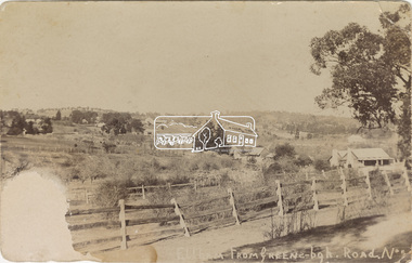 Eltham District Historical Society Inc
Postcard - Photograph, Eltham from Greensborough Road, No. 1, c.1910
The view is looking southeast from near Eltham Road (present-day Sherbourne Road) across Bolton and Bridge streets towards the village of Little Eltham running down the main road (Maria Street) . On the immediate right is Mrs Mary Jane Smart's family home located on the north side of Bridge Street at the intersection with Bolton Street, facing Bolton Street (now part of present day Brisbane Street and occupied by the Kitchen Design Centre). An original early settler's cottage, it was built by Mary Jane Smart's parents, Edwin Bailey and Jane (nee Matthews). Mary Jane Smart was born in the cottage. She married an Englishman, Alexander Wilson Smart who disappeared to Western Australia in the early 1900s in search of gold. He ultimately married again in W.A., committing bigamy and then committed murder and was hung in 1911. Visible at the top left are Watson's (two-storey) Eltham Hotel at the corner of Pitt Street and Maria Street and the Evelyn Hotel directly opposite.Sepia postcardNotations in biro 'A. Petrie', rest in pencil as follows St Margarets N end Shows Wesleyan Church Small Bank Double Storey on Hotel's south end Pearsons house Note roof structure Surface damage to lower left corner1910, bridge street, cba bank, church, clark bros. photo, early settlers, eltham, eltham hotel, evelyn hotel, fountain of friendship hotel, greensborough, mary jane smart (nee bailey), pearson house, pre 1900, road no 1, smart family home, smart home, st margarets, watsons hotel, wesleyan church -
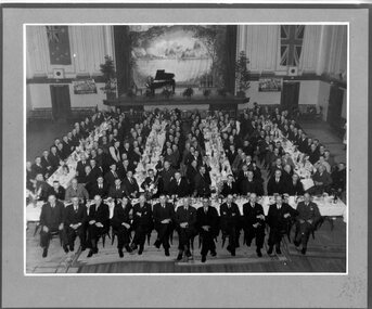 Victoria Police Museum
Photograph (Victoria Police), Police Officers on dinner event, February 1945
[see inscriptions] Black and white mounted photograph. Approximately 160 men (171 according to inscription on the back) sitting on large tables at a formal dinner event; all weatinh suits and posing for photograph. Photo was taken in a large rooom with a stage, Malvern Town Hall accoring to inscriptions on the back - tables occupy centre and front of photograph - but in the background: [left] Australia flag, WWII poster; [center] stage with painted landscape and piano; [right] WWII poster and Britain flag. [information of event on newspaper cutting stuck on the back - as described on Inscriptions]Handwritten: 171 PRESENT // FEB 1945 // (?) OFF SUPT KNOTT // INSPT SAMBLEBE // CONST GRAMBEU /// MALVERN TOWN HALL Newspaper cutting glued to frame: Supt. J. R. H. Knott, has rettired from the Police Force after 38 and half years' service, was farewelled by citizens and police officials at Malvern Town Hall on Tuesday night, The mayor of Malvern (Cr. J. Johnson) presided and presented SUpt. Knott with a chair and a wallet of notes. Similar presentations were made to Inspector C.H.D. Samblebe and First Constable O. Grambau, who have also retired. Supt. A.D. McKinnon of Ballarat will succeed Supt. Knott // handwritten: SUN 1/2/45victoria police museum, police officers, police academy, police force, superintendent mckinnon, superintendent knott, cr johnson, inspector samblebe, first constable grambau, poulter, william -
 Orbost & District Historical Society
black and white photograph, November 9 1896
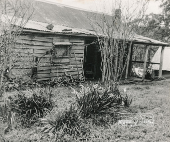
There is no information with this photograph. It could be a photograph of the first house that Henry James occupied.Henry James (1860-1932) was a well-known identity in the Orbost district.He was a stock agent and auctioneer who helped to establish the seed bean industry in Orbost. He was the second secretary of the Snowy River Shipping Co. as well as a shire councillor and prominent member of MUIOOF.A black / white photograph of a light coloured timber house with a neat picket fence in front. On the right is a trellis with trees behind it. On the left there is a barn and a shed in the backyard.on back - JAMES HOUSE - November 1896 (Henry James?)house-james -
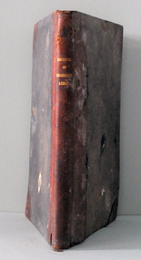 Orbost & District Historical Society
register, Register of Residence Areas, 10.2.1897 - 4.9.1934
This book is a register of land holders with miners' rights. The correspondence is associated with applications for miners' rights on privately owned land and business sites. They include application fotrms and objections to registrations. The areas referred to are Combienbar, Goongerah, Club Terrace, Wombat Creek and Dundong. One of the privileges under the Mines Act, conferred by the holding of a miner's right until 1935 was that of residence on up to one acre on a gold-fields area. Those occupying a residence area were "deemed in law to be possessed ... of such ... parcels ... and the property therein".This is a useful research tool.A large, heavy book with a grey cloth cover and red spine. The end papers are marbled. The inside pages are ruled in grey with red ruled columns. Entries are hand-written. There are copies of correspondence inside. Details given are the registration number and date, the name of the person, the number of the miner's right and its date, a description of the allotment and any remarks or references to other volumes. Any changes of ownership are shown. The book is mostly unused.register-mining miners-rights -
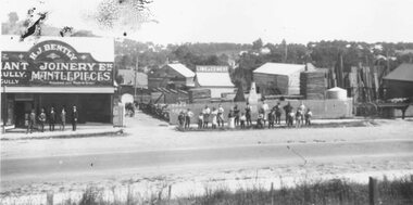 Ringwood and District Historical Society
Photograph, Maroondah Highway East, Ringwood- 1920. H.J. Bently, Timber Merchant and Joinery
Black and white photograph (2 copies) Typed below one photograph: "Maroondah Highway 1920. Coffeys now on right and building on left still there (1979)" Written on rear of backing sheet: "Whitehorse Road 1920- Coffeys site- looking north. Shop now rebuilt and occupied by Lawford. Building behind 'H. J. Bentley' sign still there 1976 as part of Lawfords. Matlocks Livery Stables in background to left of 'Lime and Cement' sign. -
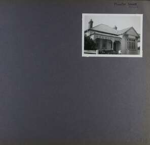 Glen Eira Historical Society
Album - Album page, Munster Avenue, Circa 1972
This photograph is part of the Caulfield Historical Album 1972. This album was created in approximately 1972 as part of a project by the Caulfield Historical Society to assist in identifying buildings worthy of preservation. The album is related to a Survey the Caulfield Historical Society developed in collaboration with the National Trust of Australia (Victoria) and Caulfield City Council to identify historic buildings within the City of Caulfield that warranted the protection of a National Trust Classification. Principal photographer thought to be Trevor Hart, member of Caulfield Historical Society. Most photographs were taken between 1966-1972 with a small number of photographs being older and from unknown sources. All photographs are black and white except where stated, with 386 photographs over 198 pages. This house continues to occupy the property at 5 Munster Avenue Carnegie (Google map image capture Feb 2019).Page 136 of Photograph Album with one landscape photograph of an Edwardian house on Munster Avenue.Handwritten: Munster Street / Avenue [top right] / 136 [bottom right]trevor hart, garden, verandah, bull nosed verandah, edwardian, coloured glass, corrugated iron roof, bay window, gable, chimneys, porch, munster avenue, carnegie, box bay window, weatherboards, cast iron work, timber houses -
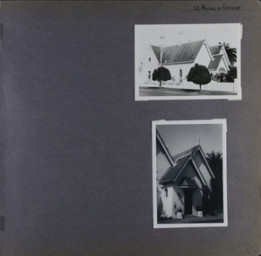 Glen Eira Historical Society
Album - Album page, Avoca Grove, 12, Circa 1972
This photograph is part of the Caulfield Historical Album 1972. This album was created in approximately 1972 as part of a project by the Caulfield Historical Society to assist in identifying buildings worthy of preservation. The album is related to a Survey the Caulfield Historical Society developed in collaboration with the National Trust of Australia (Victoria) and Caulfield City Council to identify historic buildings within the City of Caulfield that warranted the protection of a National Trust Classification. Principal photographer thought to be Trevor Hart, member of Caulfield Historical Society. Most photographs were taken between 1966-1972 with a small number of photographs being older and from unknown sources. All photographs are black and white except where stated, with 386 photographs over 198 pages.From Glen Eira Heritage Management Plan (1996) by Andrew Ward and Associates: The house at 12 Avoca Grove, part of "Merton", now demolished, is understood to have been built for and occupied by James Wilberforce Stephens from c.1865. It has aesthetic and historical significance. The building's aesthetic value is derived from the manner in which it demonstrates aspects of the Cottage Orne style, popular among Melboume's gentry during the mid Victorian period. Its historical value is derived from its association with J. W. Stephens, MLA, for East St Kilda and a prominent Caulfield resident.Page 20 of Photograph Album - two black and white exterior photographs of a house with both photographs on the right hand side of the page, the top in landscape mode and the bottom portrait. Hand written: 12 Avoca Grove [top right of page] / 20 [bottom right]trevor hart, avoca grove, church, caulfield north, merton, james wilberforce stephens, cottage orne style, j w stephens (mla) -
 Glen Eira Historical Society
Album - Album page, Paynswicke, Gladstone Pde & Hartington St, Circa 1972
This photograph is part of the Caulfield Historical Album 1972. This album was created in approximately 1972 as part of a project by the Caulfield Historical Society to assist in identifying buildings worthy of preservation. The album is related to a Survey the Caulfield Historical Society developed in collaboration with the National Trust of Australia (Victoria) and Caulfield City Council to identify historic buildings within the City of Caulfield that warranted the protection of a National Trust Classification. Principal photographer thought to be Trevor Hart, member of Caulfield Historical Society. Most photographs were taken between 1966-1972 with a small number of photographs being older and from unknown sources. All photographs are black and white except where stated, with 386 photographs over 198 pages. House is commonly spelt as "Payneswicke".From: Glen Eira Heritage Management Plan (1996) by Andrew Ward and Associates "Payneswicke" is locally significant as a prominent and substantially intact villa of its period, distinguished by its cast cement enrichment, unpainted stuccoed surfaces and commanding aspect to the south-west. Its role for a period as home for local builder, Patrick Millane (compare no. 11 Gladstone Parade) is of interest. In 1889, a nine roomed brick house was in the course of erection on the site. The house was completed in 1890 and Millane took up residence. Millane continued as owner/ occupant in 1894. However, in 1899, although Millane still occupied the house, ownership had been taken over by the Land Mortgage Bank. By 1910, Andrew Brown was occupant. Occupancy passed to Edward Brown by 1920 and to Miss A.N. Brown by 1930. Miss Brown continued to live there in 1941.Page 50 of Photograph Album with three exterior photographs (2 landscape and 1 portrait) of Paynswicke, a double storey house.Hand written: No 13 [top right] / "Paynswicke" N.E. cnr Gladstone Pd & Hartington St [top right] / 8 Oct 1966 [under top left photo] / 50 [bottom right] trevor hart, 1880's, 1890's, payneswicke, patrick millane, gladstone parade, unpainted stuccoed surfaces, cast cement enrichment, hartington street, villa residence, italianate, elsternwick, victorian, mansion, cast iron verandahs, return verandahs, curved windows, full length windows, land mortgage bank, andrew brown, edward brown, a n brown, paynswicke -
Federation University Historical Collection
Programme, Programme for the Official Opening of the Mt Helen Campus, 10/1970
The first building at the Mt Helen Campus was opened in October 1970. Students first starting using the campus in the same year. The programme includes the following historical information: "On 26th October, 1870, Sir Redmond Barry officially opened the first venture into formal technical education in Australia - the Ballarat School of Mines. Over the preceding year a small group of Ballarat citizens interested in mining had conceived and brought into being the idea of creating such a school. They leased a derelict Court House next to the Ballarat Gaol in Lydiard St., at a nominal rental for15 years, and started classes with 4 students and an honorary lecturer. The School developed its courses beyond the initially intended range of studies related to mining, increased in enrolments, took over neighbouring properties and buildings and developed three levels of education - tertiary, trade and secondary. From the latter part of the 19th Century, even though remaining under the control of its own autonomous Council, it developed close links with the State Education Department. From the earliest times the School achieved widespread recognition and a particularly high reputation, and its graduates spread across Australia and the world. For several years it was affiliated with Melbourne University. In the last decade its scope has been further broadened by the introduction of new tertiary courses. During 1965 the State Government created the Victoria Institute of Colleges - a non-teaching body empowered to award degrees and directed towards the task of co-ordinating and developing tertiary education in Victorian in institutions other than universities. the tertiary division of the School became affiliated with the V.I.C. at the end of that same year. Subsequently the Council of the School decided that, whilst retaining for the whole establishment the time honoured title - The School of Mines and Industries, Ballarat - it should more distinctly sub-title the three divisions. the tertiary division then became known as the Ballarat Institute of Advanced Education. On receipt of substantial Commonwealth-State Grants, made to it as a college of advanced education, the Council was enabled at the start of 1967, to purchase for the Institute the 20 acre campus at Mt Helen. A master plan has been produced to develop this beautiful and spacious site as a tertiary institution enrolling, in due course, some 3000 full time students. the first sod was turned, to initiate this development, by the then Governor General of Australia, The Right Honourable Lord Casey, on 19th October, 1967. The first building group, now completed and occupied, has involved an expenditure approaching $1,000,000. It contains the departments of Mechanical, Civil and Mining Engineering, Metallurgy and Geology. it also contains the Computer Centre, a temporary Library and temporary student amenities. Over the next two years a further four buildings, costing about $2,500,000, will be erected, and a further major portion of the Institute will move to Mt Helen. these buildings, in addition to one for direct teaching work, will include a Library, a Union and the first stage of a Hall of Residence."White, folded, paper programme printed on the occasion of the official opening of the Ballarat Institute of Advanced Education (BIAE) Mount Helen Campus on the occasion of the centenary of the Ballarat School of Minesuniversity of ballarat, ballarat school of mines, biae, mount helen, mt helen campus, mb john, jack barker, e.j. barker, rolly parfenovics, parfenovics, nigel bown, campus. victorian institute of colleges, m.b. john -
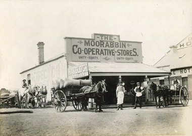 City of Moorabbin Historical Society (Operating the Box Cottage Museum)
Photograph - Photograph, 1906 The Moorabbin Co-Operative Stores, 1906 The Moorabbin Co-Operative Stores, 1906
1906: The Moorabbin Co-Operative Stores. Located on the Nepean Road, Cheltenham, (before 1st WW). . There are four men outside the Store and a 3 horse carriage. Two of the men are sitting on their carriages, one to the left and the other on the right of the photograph. The third horse and carriage is right beside the left of the store, carrying eight large sacks. Towards the side of the Moorabbin Stores there is a building located to right which is called The Exchange Hotel.1906: The Moorabbin Co-Operative Stores. Located on the Nepean Road, Cheltenham, (before 1st WW). The Leader Newspaper office occupied the site. The Exchange Hotel is to the right.Photograph is black and white. 1906: The Moorabbin Co-Operative Stores. Located on the Nepean Road, Cheltenham, (before 1st WW). The Leader Newspaper office occupied the site. The Exchange Hotel is to the right.Stamped on back :City of Moorabbin Historical Society Written on Front of mount : 1906moorabbin, stores, horses, men, ww1, world war 1, tobacco, nepean road, co-operative, cheltenham -
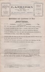
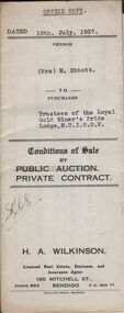 Bendigo Historical Society Inc.
Document - H.A. & S.R. WILKINSON COLLECTION: CONTRACT OF SALE
Conditions of sale by private contract dated 19th July, 1937 between Mrs. M. Ebbott (seller) and Trustees of the loyal Gold Miner's Pride Lodge M.U.I.O.O.F. (buyers) for land situate No.430 High Street, Bendigo being part of Crown allotments 1 & 2A section 38A described in certificate of title volume 3645 folio 728944. Also all the vendor's right, title and interest in that piece of permissive occupancy land described in permit to occupy No. W.54098, together with all buildings on the above mentioned land.. Price 306 pounds and 5 shillings.organization, business, h.a. & s.r wilkinson real estate -
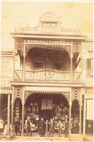 Bendigo Historical Society Inc.
Photograph - BLACK AND WHITE PHOTOGRAPH OF THE 'NEW TIMES' BUILDING OCCUPIED BY ABBOTTS BOOTS AN SHOES
Black and white photograph of the 'New Times' building in Pall Mall, next to myer. The top has a rather ornate masonry design. The lower edge of the guttering of the top verandah and the lower edge of the guttering at floor level of the top floor is a very ornate lacework display.Centre bottom is hitching post for horses. Signage on the building reads Manufacturers of Boots and Shoes, Abbott & Co is also faintly displayed. An adult male, and female standing next to the hitching post. A young man has his right arm draped over the hitching post and two other young people to his right. Two other young boys are standing between two posts on the left side. The business to the left is using two posts to support bags that are ready for sale. A male in white is at the very left of the photo.buildings, commercial, abbotts boot & shoe manufacturers -
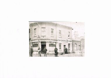 Bendigo Historical Society Inc.
Photograph - BLACK AND WHITE PHOTO OF THE HIBERNIA HOTEL LOCATED IN BRIDGE STREET
Black and white photograph of the Hibernia Hotel located at the corner of Bridge and Cemetery Streets Bendigo. Opposite Mulqueen funeral parlour. Currently owned and occupied by the Chinese Association of Bendigo. Top floor has five multi paned glass windows, the lower half of the window on the extreme right is broken. Above the door are the words 'Licensed to Sell Fermented & Spirituous Liquors'. Also the name P. M. McGrath. Windows each side of the door are 3 pane of which the lower half is decorated with the word BAR. To the right and part of the building is the name P. M. McGrath's Court. A lady and child are standing to the right in front of a door. The lady is dressed in black and the girl is dressed in what might be described as a colourful outfit.Four men are standing under a 'gas light' opposite the bar door. All are dressed in dark clothing with hats of different styles. The man to the right has a dog at his feet looking at the cameraman.bendigo, history, buildings/streetscapes -
 Bendigo Historical Society Inc.
Document - H. A. & S. R. WILKINSON COLLECTION: CONTRACT OF SALE
Conditions of sale by private contract dated 14th December, 1946 between Mr. J. R. Shields (vendor) and Mr. L. J. Trigg (purchaser). Property: land situate No. 110 Garsed Street, Bendigo at present occupied by Mrs. Cook as tenant, being part of Crown allotment 5 and 6 section 116C Parish of Sandhurst city of Bendigo described in certificate of title volume 1397 folio 279304, together with the right of carriage way over land coloured brown on map on certificate of title, together with 5 roomed weatherboard and rough cast dwelling and sundry outbuildings. Price: 1,020 pounds.organization, business, h.a. & s.r wilkinson real estate -
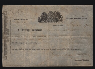 Bendigo Historical Society Inc.
Document - MINERS RIGHT/LAND LEASE, 1870
Document. Miners Right/Land Lease. Paper document dated 4th April 1870 authorizing Simon Albert to construct a puddling mill and dam on land in Devonshire Gully. It reads: I hereby authorize Simon Albert to occupy a piece of land, situated in Devonshire Gully and marked 'A' on the plan deposited in my office for the purpose of constructing a puddling mill and dam, thereon, and to hold the same until the ground is again required by the Government. Printed by John Ferres, Government Printer, Melbourne. Signed by Resident Warden (Signature Unreadable). Lithograph drawings - one of a lion and unicorn with Latin writing.cottage, miners, miners right/land lease, simon albert, devonshire gully, john ferres governmant printer -
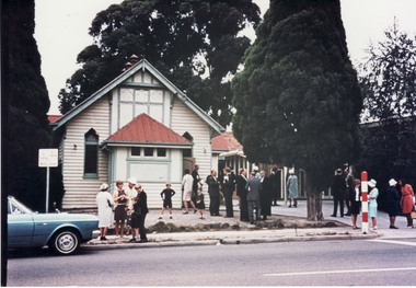 Whitehorse Historical Society Inc.
Photograph, Methodist Church, Mitcham, 26/02/1967 12:00:00 AM
Coloured photo of Methodist Church, Mitcham Road, Mitcham. Original street number 115-117, now 339. Service station presently occupies this site. Newer church hall on southern side - land previously occupied by church tennis court. Two medical practices located nearby - Dr. Liebert directly adjacent to left -taken up by Dr. Carter and Dr. Cochrane three houses to right- taken over by Drs. Threlkeld and Twiddy. Both practices now absorbed by 'progress'.methodist church, mitcham. -
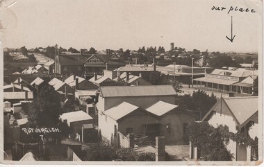 Rutherglen Historical Society
Image, 1910s
The large building left of centre is the Star Hotel. Two sides of Main Street on the eastern side of High Street are occupied by shops of David G HamiltonBlack and white postcard photograph of Rutherglen rooftops, probably taken from the roof of the Soldiers' Memorial Hall at the corner of Murray and High Streets.At bottom left of photo: "Rutherglen. 7." Written at top right of photo, with an arrow pointing to a house: "Our place". On back of card: "Rutherglen. April 4th 1918 [or 1910 - illeg.] | My dear Sister Marion, Mumma, Sadie, Florrie, Ruth & Mavis all join in wishing you Many Happy Returns of Your Birthday. We received Joan's letter today. Hope you are all well & that your arm is alright. Ruth is getting along nicely. Best love to all. Your affectionate Brother George."rutherglen, main street, high street, d g hamilton, star hotel