Showing 285 items
matching roadwork
-
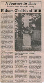 Eltham District Historical Society Inc
Folder, Eltham Obelisk (later Cenotaph), 1918-2018
The Eltham Obelisk was originally located at the corner of Bridge and Main Roads in 1919. In 1943 (WW2) the local community commenced plans to establish the Eltham War Memorial, a living memorial to benefit the children as opposed to a one in stone as per the obelisk. The Eltham War Memorial Trust was established in 1945. In 1947 the Trust intended for the Obelisk to be relocated from Bridge Street and Main Road to the Garden of Remembrance which was planned as part of the Baby Health Centre which was to be the first of three buildings of the Eltham War Memorial to be built in 1951. In 1951 the Eltham RSL was invited to be represented on the Eltham War Memorial Trust. Around this time, with pending roadworks, the obelisk was relocated to the front garden of the Eltham RSL sub branch on Main Road for safe keeping. In 2007, a suggestion was proposed by Harry Gilham (President, EDHS) to John Cohen (ERSL) to claim a special site along with the historic Shillinglaw trees on the now vacant former Eltham Shire Office site adjacent to the Eltham War Memorial precinct for relocation of the obelisk. In 2010 following the financial collapse and sale of the Eltham RSL Sub-Branch property and amalgamation with the Montmorency Eltham RSL sub-branch, the location of the obelisk was again in immediate jepoardy and in conjunction with Nillumbik Shire Council, the obelisk was relocated in front of the Eltham War Memorial buildings in preparation for the Dawn Service on Anzac Day 2012. Contents: Newspaper article: Eltham Obelisk of 1919, Harry Gilham, August 2000 as well as draft submitted dated 22 Aug 2000 Newspaper article: Eltham, The Advertiser 15 Nov 1918 and 18 Nov 1918 Newspaper article: An Obelisk at Eltham, The Advertiser, 11 Jul 1919 Newspaper advertisement: Unveiling of Obelisk at Eltham, The Advertiser, 1 Aug 1919 Newspaper article: Eltham Soldiers’ Memorial; Unveiled by Sir William Irvine, The Argus, Monday, 4 Aug 1919, p8 Newspaper article: Eltham Memorial to Fallen Soldiers, Diamond Creek Valley Advocate, 8 Aug 1919 Newspaper article: Memorial to the Fallen; Unveiled at Eltham, The Age, Monday, 4th August 1919 Newspaper article: Programme - Presentation of German Machine Gun at the Obelisk, Eltham on Sunday, 8th August, 1920, at 3.30 P.M. Newspaper article: article about presentation of a war trophy, a heavy machine gun placed beside obelisk, The Advertiser, 13 Aug 1920 Newspaper article: Eltham: ANZAC Services, The Advertiser, Friday, May 2, 1924 Newspaper article: Eltham War Memorial, The Advertiser, Oct 26, 1928 Handwritten note from Harry Gilham (President EDHS) to John Cohen (ERSL) regarding history of Eltham RSL site and 1947 newspaper article "Eltham War Memorial Trust "Garden of Remembrance" referencing relocation of Obelisk to the proposed Garden of Remembrance at the Baby Health Centre (Eltham War Memorial). Officers' reports, 11.113/10 Relocation of Eltham RSL Cenotaph, Nillumbik Shire Council Ordinary Meeting, 21 December 2010 Email Correspondence: EDHS President to NSC General Manager Community and Leisure re RSL Obelisk (Cenotaph) proposed relocation, 24 May 2011 Newsletter Extract: Eltham RSL and War Memorial, EDHS Newsletter 14 Sep 2011 Officers' reports, OCM.091/11 Interim Relocation site for the Eltham Cenotaph, Nillumbik Shire Council Ordinary Meeting, 23 August 2011 Officers' reports, OCM.004/121 Interim Relocation of the Eltham Cenotaph, Nillumbik Shire Council Ordinary Meeting, 31 January 2012 (includes Funding agreement between NSC and Montmorency-Eltham RSL Sub-branch Inc) Newspaper article: Move war memorial: RSL, c.2011 Newspaper article: Memorial move lags, Diamond Valley Leader, 1 February 2012 Newspaper article: New dawn for tribute, Diamond Valley Leader ca April 2012 Open letter to the residents of Eltham and Montmorency and copies of drafts by the Montmorency Eltham RSL, no date and final version published in Diamond Valley New 21 March 2012 and Banyule & Nillumbik Weekly, 27 March, 2012 Newspaper article: RSL site nets $1.8m, Diamond Valley Leader, 9 May 2012 Newspaper article: Memorial Moved, Banyule/Nillumbik Weekly, 10 April 2012 Newspaper article: Eltham cenotaph move goes 'like clockwork', Diamond Valley Leader, 11 April 2012 Advertisement, Program for Eltham Dawn Service, Diamond Valley Leader, April 2012 Newspaper photo: Veterans (l-r) Alan Field, Max Lowerson and John Cohen will join piper David Cretney to commemorate fallen Diggers, 2012 (standing beside relocated obelisk in front of the Eltham War Memorial complex) Program for Montmorency Anzac Day March 2012 (incomplete, some pages duplicated, some pages upside down). Newspaper article: Plan to expand memorial, Diamond Valley Leader, Sep. 2004, p5 Newspaper article: Names renewal, thanks to Barry, Diamond Valley Leader, 18 Apr 2007, p3 with picture featuring Eltham RSL president John Haines and Gwen Rosewall Letter: EDHS President to Manager Community Participation, Learning and Culture, Nillumbik Shire Council regarding a proposal by the Montmorency-Eltham RSL Sub-branch to expand the area occupied by the relocated obelisk further into the Eltham War Memorial Garden of Remembrance, 18 Aug 2014 Notices of Motion, NOM.001/14 pertaining to memorials Advisory Committee and Montmorency-Eltham RSL to upgrade the Eltham War Memorial site in time for ANZAC Day 2015, Nillumbik Shire Council Ordinary Meeting, 26 August 2014 Agenda: User Groups and Stakeholders Meeting, Proposed Extension to Memorial Terrace, 11 September 2014 EDHS presentation to NSC Policy and Services meeting 9 September 2014 regarding the Montmorency-Eltham RSL proposal to expand/upgrade the Eltham War Memorial Policy and Services reports, PSD.034/14 Eltham War Memorial Building Precinct - Proposed Extension to Memorial Terrace, Nillumbik Shire Council Ordinary Meeting, 9 September 2014 Email (copy): President EDHS re Eltham War Memorial Complex, Main Road, Eltham, 15 Sep 2014 requesting Nillumbik Shire Council place a Heritage Overlay upon the Eltham War Memorial Complex Media Release: Support for cenotaph expansion, Nillumbik Shire Council, Sep 2014 Newspaper article: Council defers RSL war memorial upgrade to see consultation, Diamond Valley News, 17 Sep 2014 Letter (copy): Harry Gilham, Eltham to local press and others, 20 Sep 2014 protesting attempts by the RSL to further expand upon the area already ceded from the Eltham War Memorial for the relocated WW1 obelisk and alter the original vision for an Eltham War Memorial complex. Letter: Alan Field, President, The Eltham Veterans War Memorial Preservation Society Inc. to CEO and Councillors, Nillumbik Shire Council protesting at perceived injustices and ‘veteran bashing’ regarding their previous efforts to relocate ‘their Obelisk and Cenotaph’ to the Eltham War Memorial complex and their frustration in their attempts to further expand upon the Memorial Terrace. Areas of letter are highlighted with handwritten markups and notes. Also notes on loose card and paper with definitions of Memorial, Obelisk, Cenotaph, commentary on establishment of Eltham War Memorial, The Eltham War Memorial Trust and RSL involvement and current actions by RSL in respect to claims in the letter (written by Harry Gilham ?). Policy and Services reports, PS.038/14 Eltham War Memorial Building Precinct - proposed extension to the Eltham Cenotaph Terrace, Nillumbik Shire Council Policy and Services Committee Meeting, 14 October 2014 Newspaper article: Centenary dawn service moves to Petrie Park, Diamond Valley Leader, 22 Oct 2014 Newspaper article: Upset over upgrade; war memorial revamp plans get culled, Diamond Valley Leader, 29 Oct 2014 Newspaper article: Memories of our heroes, Diamond Valley Leader, 25 Apr 2018 – also Veteran saluted, featuring article on Army veteran, Glen Ferrarotto. Handwritten notes in pencil (2 pages) by Harry Gilham, Items form the Eltham and Whittlesea Shires The Advertiser newspaper 7 June 1918 - 1919 providing a summary of the formation of the Peace Celebration Committee leading to the establishment of the Avenue of Honour and the Eltham Obeliskeltham cenotaph, nillumbik shire council, eltham war memorial, montmorency eltham rsl sub-branch, dawn service, cenotaph, eltham rsl sub-branch, eltham war memorial trust, garden of remembrance, harry gilham collection, john cohen, obelisk, remembrance garden, shillinglaw trees, german machine gun, war memorial, war trophy -
 Ringwood and District Historical Society
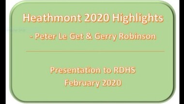
Mixed media - Video, RDHS Guest Speaker Presentation - "Heathmont 2020 Highlights" - Gerry Robinson and Peter Le Get
Digitised video (1.11GB). Duration: 20 minutes. Recorded March, 2021. (Video is available for viewing at Ringwood & District Historical Society Archives by appointment)Presenters: Gerry Robinson and Peter Le Get of Heathmont History Group (HHG) look back over developments in the area over the previous year. HEATHMONT HIGHLIGHTS FOR 2020 Summary - "Of course for 2020 the Covid 19 virus dominated. Other finalists included roadworks on Bedford Road corner, new Wards for MCC and their elections, 100th birthday and death of Rita James, opening of Milk & Wine Co. café replacing Barclays, election of Kylie Spears as Mayor, closure of Heathmont Medical Centre, demolition of Miller homestead in Coven Avenue, final edition of Maroondah Leader local newspaper, opening of HE Parker Sports pavilion, 50 more bollard arts, and the ugliness of the former Anglican Church and other local sites." -
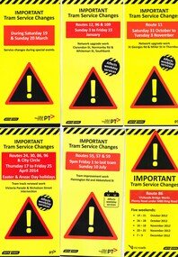 Melbourne Tram Museum
Pamphlet, Yarra Trams, "Important Tram Service Changes", 2012 to 2016
Set of 24 pamphlets, DL size when folded, Full colour, titled "Important Tram Service Changes", giving details of interruptions to the tram system due to Roadworks or events. Have been number .1 to .3 and .5 to .26. Have the logos of Yarra Trams, VicRoads, PTV, .1 - Grand Prix 2016 .2 - Roadworks - Clarendon St, Normandy Road and Whiteman St Southbank, track reconstruction of Southbank or Port junction accessible tram stops, 3/1/16 to 15/1/16 - put in siding for the Restaurant Tram .3 - Route 11 - reconstruction of junction into Preston Workshops - Oct. 2015 .5 - Victoria Parade and Nicholson St intersection reconstruction - April 2014 .6 - Reconstruction of junction - Abbotsford St and Flemington Road - July 2016 .7 - Route 86, VicRoads bridge works - Plenty Road - Oct. to Dec. 2012 .8 - Route 70, Swan St, Burnley track renewal - June 2012 .9 - as for .7 .10 - Route 70, Riversdale Road, Camberwell track renewal, Nov. 2012 .11 - Chapel and Carlisle Sts, Trackwork - June 2013 .12 - ditto .13 - Route 86 - Gertrude and Smith Streets Collingwood .14 - Route 78 and 79 - track renewal Chapel St Sept. 2013 .15 - Elizabeth St track reconstruction and accessible tram stops - Oct. 2013 - see also Reg Item 859. .16 - Tram track renewal, Mt Alexander Road - Ormond Road and Kent St - Routes 55 and 59 - Feb. 2014 .17 - St Kilda Road, between Southbank Blvd and Park St - Feb. 2014 .18 - Overhead Renewal Camberwell depot - March 2014 .19 - Gilbert Road and Miller St - track and overhead renewal - July 2014 .20 - Tram stop works - Melbourne and Olympic Park - August 2014 .21 - Tram stop works - Melbourne Town Hall - Collins St - August 2014 .22 - Matthews Ave, Airport West, route 59 - September 2014 .23 - Tram stop works, Flinders St - Sept. 2014 .24 - Tram stop works - Bourke and Swanston St - Oct. 2014 .25 - Tram stop works - Flinders Jan. 2015 .26 - Elizabeth St works - May and July 2013trams, tramways, grand prix, trackwork, overhead, southbank, tram stops, route 11, victoria parade, nicholson st, preston workshops, abbotsford st, flemington rd, route 86, chapel st, carlisle st, gertrude st, smith st, riversdale rd, swan st, route 70, route 55, route 59, mount alexander rd, st kilda rd, camberwell depot, gilbert rd, miller st, collins st, route 59, matthews ave, flinders st, port junction -
 Eltham District Historical Society Inc
Photograph, Eltham War Memorial 1914-1918. Cnr. Main Road and Bridge Street, 3 August 1919
Dated 1919, the Eltham Obelisk is decorated with wreaths, most likely for what was originally known as Armistice Day though now known as Remembrance Day, 11 November. The location of the Obelisk at the corner of Bridge Street and Main Road became known as Obelisk Corner and the Bridge Street bridge was also referred to as Obelisk Bridge. The Eltham Obelisk was originally located at the corner of Bridge and Main Roads in 1919. In 1943 (WW2) the local community commenced plans to establish the Eltham War Memorial, a living memorial to benefit the children as opposed to a one in stone as per the obelisk. The Eltham War Memorial Trust was established in 1945. In 1947 the Trust intended for the Obelisk to be relocated from Bridge Street and Main Road to the Garden of Remembrance which was planned as part of the Baby Health Centre which was to be the first of three buildings of the Eltham War Memorial to be built in 1951. In 1951 the Eltham RSL was invited to be represented on the Eltham War Memorial Trust. Around this time, with pending roadworks, the obelisk was relocated to the front garden of the Eltham RSL sub branch on Main Road for safe keeping. In 2007, a suggestion was proposed by Harry Gilham (President, EDHS) to John Cohen (ERSL) to claim a special site along with the historic Shillinglaw trees on the now vacant former Eltham Shire Office site adjacent to the Eltham War Memorial precinct for relocation of the obelisk. In 2010 following the financial collapse and sale of the Eltham RSL Sub-Branch property and amalgamation with the Montmorency Eltham RSL sub-branch, the location of the obelisk was again in immediate jepoardy and in conjunction with Nillumbik Shire Council, the obelisk was relocated in front of the Eltham War Memorial buildings in preparation for the Dawn Service on Anzac Day 2012.This photo forms part of a collection of photographs gathered by the Shire of Eltham for their centenary project book,"Pioneers and Painters: 100 years of the Shire of Eltham" by Alan Marshall (1971). The collection of over 500 images is held in partnership between Eltham District Historical Society and Yarra Plenty Regional Library (Eltham Library) and is now formally known as 'The Shire of Eltham Pioneers Photograph Collection.' It is significant in being the first community sourced collection representing the places and people of the Shire's first one hundred years.Digital image 4 x 5 inch B&W Negsepp, shire of eltham pioneers photograph collection, eltham, main road, bridge street, eltham war memorial, obelisk, obelisk corner, wreath -
 Eltham District Historical Society Inc
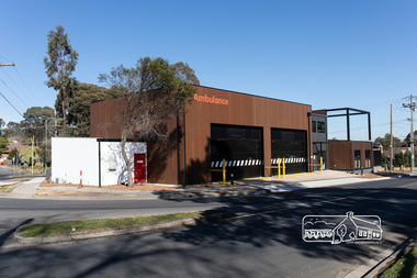
Photograph, Peter Pidgeon, Official opening of the new Eltham Ambulance Branch, Apex Way, Montmorency, 29 August 2018, 29 Aug 2018
Dignitaries included Ambulance Victoria CEO Tony Walker, Vicki Ward MP for Eltham and Jill Hennessey State Ambulance Services Minister The Eltham Apex Club conducted a Community Service Project (1965-1968) to raise funds for a new Ambulance Station to service the community. A site bounded by the intersection of Main Road, Grand Boulevard and Looker Road at Montmorency was purchased in 1969. In 1970, Eltham Shire Council undertook roadworks to construct Apex Way in preparation for the new station as well as duplicate Main Road, Lower Plenty, east of Grand Boulevard including the new Lower Plenty Bridge, which had been opened in November 1966, bordering with the City of Heidelberg. Diamond Valley Leader, September 5, 2018, p4. MONTMORENCY $1.6mil station unveiled A REVAMPED Montmorency ambulance station has been unveiled. State Ambulance Services Minister Jill Hennessy and Eltham State Labor MP Vicki Ward revealed the $1.6 million complex at the corner of Grand Boulevard and Apex Way in Montmorency. It replaces the 50-year-old station and now includes four ambulance bays, four rest and recline rooms, a large training room and offstreet parking for staff. “The community campaigned long and hard for this new ambulance station and I’m delighted to have stood with them all the way,” Ms Ward said. The latest quarterly performance data showed 90.4 per cent of ambulances in Banyule arrived within 15 minutes of Code 1 emergencies — up from 89.2 per cent three months earlier. Ms Hennessy said paramedics had worked in “cramped” facilities. “We’ve fixed that,” she said.55 born digital imagesambulance victoria ceo, apex way, apex-diamond valley ambulance station, eltham ambulance station, eltham apex club, jill hennessey, montmorency, mp for eltham, state ambulance services minister, tony walker, vicki ward -
 Eltham District Historical Society Inc
Negative - Photograph, Eltham War Memorial Obelisk 1914-1918, cnr. Main Road and Bridge Street, c.1925
Located on what was referred to as Obelisk Corner, improvements have been been made since the unveiling in August 1919 with the provision of a stone retaining wall topped with a chain link and granite stone boundary, most likely in conjunction with improvements to the intersection into Main Road. Along with the use of the name Obelisk Corner, the Bridge Street bridge was also known as Obelisk Bridge. The Eltham Obelisk was originally located at the corner of Bridge and Main Roads in 1919. In 1943 (WW2) the local community commenced plans to establish the Eltham War Memorial, a living memorial to benefit the children as opposed to a one in stone as per the obelisk. The Eltham War Memorial Trust was established in 1945. In 1947 the Trust intended for the Obelisk to be relocated from Bridge Street and Main Road to the Garden of Remembrance which was planned as part of the Baby Health Centre which was to be the first of three buildings of the Eltham War Memorial to be built in 1951. In 1951 the Eltham RSL was invited to be represented on the Eltham War Memorial Trust. Around this time, with pending roadworks, the obelisk was relocated to the front garden of the Eltham RSL sub branch on Main Road for safe keeping. In 2007, a suggestion was proposed by Harry Gilham (President, EDHS) to John Cohen (ERSL) to claim a special site along with the historic Shillinglaw trees on the now vacant former Eltham Shire Office site adjacent to the Eltham War Memorial precinct for relocation of the obelisk. In 2010 following the financial collapse and sale of the Eltham RSL Sub-Branch property and amalgamation with the Montmorency Eltham RSL sub-branch, the location of the obelisk was again in immediate jepoardy and in conjunction with Nillumbik Shire Council, the obelisk was relocated in front of the Eltham War Memorial buildings in preparation for the Dawn Service on Anzac Day 2012.This photo forms part of a collection of photographs gathered by the Shire of Eltham for their centenary project book,"Pioneers and Painters: 100 years of the Shire of Eltham" by Alan Marshall (1971). The collection of over 500 images is held in partnership between Eltham District Historical Society and Yarra Plenty Regional Library (Eltham Library) and is now formally known as the 'The Shire of Eltham Pioneers Photograph Collection.' It is significant in being the first community sourced collection representing the places and people of the Shire's first one hundred years.Digital image 4 x 5 inch B&W Negsepp, shire of eltham pioneers photograph collection, eltham, main road, eltham war memorial, bridge street, obelisk, obelisk corner -
 Glen Eira Historical Society
Album - Album page, Normanby Road, Circa 1972
This photograph is part of the Caulfield Historical Album 1972. This album was created in approximately 1972 as part of a project by the Caulfield Historical Society to assist in identifying buildings worthy of preservation. The album is related to a Survey the Caulfield Historical Society developed in collaboration with the National Trust of Australia (Victoria) and Caulfield City Council to identify historic buildings within the City of Caulfield that warranted the protection of a National Trust Classification. Principal photographer thought to be Trevor Hart, member of Caulfield Historical Society. Most photographs were taken between 1966-1972 with a small number of photographs being older and from unknown sources. All photographs are black and white except where stated, with 386 photographs over 198 pages. From: Glen Eira Heritage Management Plan (1996) - Vol 2 by Andrew Ward and Associates The widening of Dandenong Road during the late 1980's has resulted in the destruction of the houses in the path of the roadworks and the construction of a high fence serving as a visual barrier between that thoroughfare and the remaining houses. Where comparatively large villas once stood on spacious allotments, only "Wisteria" survives at No. 135 Normanby Road. Adopting forms and timber enrichment characteristic of the American Queen Anne style, it has this in common with the largely reconstructed timber villa at no. 11 Normanby Avenue and to a lesser extent, 746 Inkerman Road. Normanby Road retains its comparatively opulent Edwardian character in a mature landscaped setting with spacious gardens and mature planes parallel with the railway reserve which, on account of the low lying ground in its vicinity has a high embankment commencing on the alignment of Malvern Grove and continuing to Caulfield Station. The earliest villas are Edwardian. Page 148 of Photograph Album with one landscape photograph of a house on Normanby Road (not Street).Handwritten: Normanby St [top right] / 148 [bottom right]trevor hart, verandah, porch, bull nosed verandah, tower house, tower, stone fence, normanby road, wisteria, american queen anne style, queen anne style, 1890's, mayfield grove, normanby street, timber houses, caulfield north, house names, edwardian, edwardian style, gardens -
 Ballarat Tramway Museum
Photograph - Digital image Set of 11, Stuart Loddington, 10 images of Ballarat trams prior to closure, 1971
Yields information about Ballarat Tramways and trams prior to the closure of the tramway system.Set of 11 digital images, comprising 1 donation text image and 10 images of Ballarat trams prior to closure, scanned from original slides by Stuart Lodington, 1971 prior to closure of the system. .1 - Donation text slide. .2 - No. 26 southbound in Lydiard St North, with the Ballarat Railway Station level crossing gates in the background. .3 - No. 27 and 30 crossing at Bell St Loop, Skipton St. (see also btm4976i4) .4 - No. 17 Wendouree Parade, near Gardens Loop .5 - Single truck tram at Victoria St terminus, taken from the west side of the Buninyong Rail line bridge, with CRB Roadwork sign, Eureka Caravan Park and Meagher Hotel in the background, possibly No. 11, see entry for .10 .6 - No. 12 and 30 crossing at the Urquhart St Loop, Drummond St South. .7 - No. 12 westbound in Sturt St, with Grenville St in the background. .8 - No. 17 at Gardens Loop with the Trolley pole being reversed. .9 - No. 30, Lydiard St North with Reid's Palace building in the background. .10 - No. 11 passing over the Buninyong rail line bridge, with Gardens via Sturt St West and a Twin Lakes sign. Has a number of children alongside the driver. .11 - No. 21 heading northbound in Wendouree Parade, Gardens, just to the north of the now BTM depot junction.trams, tramways, ballarat, level crossings, buninyong railway, lydiard st north, bell st, victoria st, wendouree parade, gardens, drummond st, sturt st, tram 26, tram 27, tram 30, tram 17, tram 12, tram 21, tram 11 -
 Eltham District Historical Society Inc
Photograph - Digital Photograph, Marguerite Marshall, Avenue of Honour, Main Road, Eltham, 20 April 2008
The suggestion of an Avenue of Honour may have been originally put forward by Lady Irvine who was a member of the Welcome Home Committee. The Avenue of Honour was established to memorialise all those from Eltham who enlisted (some of whom were still fighting overseas at the time), similarly as the Shire of Eltham (Soldiers) Memorial Park was in tribute to all from the Shire who enlisted. The twenty-seven names of those killed from Eltham were engraved on the Eltham War Memorial Obelisk unveiled in 1919 at the corner of Main Road and Bridge Street. From an article in the Heidelberg News and Greensborough, Eltham and Diamond Creek Chronicle, September 22, 1917, p. 2, it was reported: Some few weeks ago a public meeting was held in the Eltham Rechabite Hall for the purpose of forming a committee to make necessary arrangements for the return of our brave lads from the front, with the result that the following officers were elected, viz., Sir William Irvine. president; Cr. R. D. Taylor, vice-president; Rev. T. W. Sapsford, secretary; Mr R. E. Gilsenan, treasurer; with a very strong committee of local residents. Lady Irvine then suggested that it would be nice to plant an Avenue of Honor, which was carried out in a very cheerful and spirited manner on Saturday afternoon. Cr Taylor and Mr R. E. Gilsenan occupied themselves during the fore-forenoon in getting the lining-out and other preliminaries ready, but shortly after one o'clock the willing workers could be seen wending their way towards the township, with picks, shovels. &c., on their shoulders, and in a very short time the gang at work was in appearance a very lively and pretty sight, the only thing that was missing was the camera, to have had a few snapshots taken. A little after 3 o'clock Sir William and Lady Irvine, and Mr W. Gray and family, arrived by motor. Cr Taylor then explained that their object in gathering together so hurriedly to plant the avenue was on account of the lateness of the season, and being offered 100 trees, free of charge, by Cr. Wm. G. Gray; of Allwood Nursery, Hurst's Bridge (for which the committee are deeply grateful to him and the public highly appreciate his generous offer). Sir Wm. Irvine then spoke at some length on the ravages of this cruel war, and the good that must result therefrom in bringing all closer together; he also referred to our brave lads who were fighting for us, and thought it was for those at home to show their appreciation by planting the Avenue of Honor. Lady Irvine thou proceeded to plant the first tree, which was an English oak: Sir William following by planting a Spanish chestnut; and Mrs W. G. Gray a sycamore. After that the gathering refired to the entrance of Mr R. E. Gilsenan's green paddock to partake of refreshments, which the ladies had kindly provided for the willing band of workers. Work was again taken to in earnest, and the planting finished, all being satisfied that they had done good work. At the Eltham Shire Council’s monthly meeting held May 6, 1918, Cr. Gray promised to give Council £20 to £25 worth of trees if the Council would plant and guard them. His desire was that a tree be planted in the name of every soldier lad who has gone to the front. Each tree was later adorned with a brass plaque with the name of a soldier and a wooden tree guard placed around them. Over the years many trees died, and following roadworks were replanted on a new alignment. Nillumbik Shire Council is continuing this process of replanting trees in a new alignment to move them away from overhead power lines and to clear the VicRoads reserve. Covered under Heritage Overlay, Nillumbik Planning Scheme. Published: Nillumbik Now and Then / Marguerite Marshall 2008; photographs Alan King with Marguerite Marshall.; p119This collection of almost 130 photos about places and people within the Shire of Nillumbik, an urban and rural municipality in Melbourne's north, contributes to an understanding of the history of the Shire. Published in 2008 immediately prior to the Black Saturday bushfires of February 7, 2009, it documents sites that were impacted, and in some cases destroyed by the fires. It includes photographs taken especially for the publication, creating a unique time capsule representing the Shire in the early 21st century. It remains the most recent comprehenesive publication devoted to the Shire's history connecting local residents to the past. nillumbik now and then (marshall-king) collection, avenue of honour, main road, eltham -
 Federation University Historical Collection
Document - Documents, Ken Clements (BCAE Registrar), Academic Registrar Information, 1972-1988
The collection of material was collected and compiled by Ken Clements, Academic Registrar.A grey cardboard file box with information compiled by Ken Clements, the first Academic Registrar at Ballarat Institute of Advanced Education and Ballarat College of Advanced Education (later Federation Univeristy). The information includes: 1. Ballarat School of Mines advertisement for the Academic Registrar Position 2. Details of Position 3. Ballarat Institute of Advanced Educaton information for Lectureship applicants 4. Copy of Ken Clements application for the position. 5. Principal's Recipt of application note 6. Request to and reference from R.F. Colbourne 7. Request to attend for interview from Deputy Principal 8. Principal's receipt of appointment advice from Ken Clements 9. Ballarat Courier Photo of January 1972 - Deputy Principal H. Trudinger, Principal E.J. (Jack) Barker, Academic Registrar Ken Clements. 10. Plans for storage and operation of student records with Electronic Data Processing 11. Memo to Heads of Departments for current enrolment data, with Academic Registrar duties statement attached for information 12. Subject COding Scheme first draft. 13. "The Developmen of Tertiary Education in Ballarat" a report to the Victorian Minister of Education 14. Director's Advice of change of classification for Ken Clements 15. "Professional Experience Program Report: Ken Clements 1980 16. Sample commuinuicaiton re Registry Stadd traditional end of year function 17. Sample Enrolment Manual 18. Copy of application for La Troe position 19 CAEnews, April - Produced for Registry as an information service for Ballarat College of Advanced Education Staff. Includes infromation on the northwest access to the Mount Helen Campus. Photos include roadworks on Greenhill Road, a rehearsal for the play "Little Malcom", John Langer, Jayne Wilkins, Ian Gomm, Gary Gorman 20. Part of Notes for participants in Conferring Ceremony 21. Ken Clements notes re admission to tertiary education 22. Letterhead re Ballarat College of Advanced Education 23. Memo re 1988 Admission process 24. Staff Club Activities Survey 25. 1988 Enrolment Manual 26. Sundry cards used by registry for public and internal communication, 27. Listing of Ken Clement snad B. Coldwell duties March 1988 28. Docuemnts and memos re classifications of Ballarat College of advanced Education Staff, most are to do with the Academic regsitrar position 29. Notes re Ken Clements leaving Ballarat College of Advanced Education in 1988 30. Ken Clements notes for University of Ballarat Retired Staff Association Newsletter 1997 31. Ken Clements data in Ballarat University College "Biographical Archive of Retired Staff, 1996 32. Listing of some projects undertaken by Ken Clements as a volunteer at the University of Ballarat art and Historical Collection. ken clements, john langer, ian gomm, gary gorman, leslie clements, jayne wilkins, academic registrar, retired staff association, staff club -
 Ballarat Tramway Museum
Film - Movie Film & Box, Kodak, 1960
Yields information in movie film format of Ballarat trams in 1960, how the system operated and was used by people., Yields information in movie film format of Ballarat trams in 1960, how the system operated and was used by people.Movie film - 8mm, approx. 17.5 mins, with leader strip on a plastic reel, within a black and white plastic box, titled "Ballarat No. 1. 1960" contained with a cardboard box, 'Tuscan Super 8 and Standard 8 Spool and Can' . Has been transferred to DVD - see Reg item 4100 as Segment No. 1. Filmed and made by Ben Parle. Also transferred to DVD by Rod Cook Oct. 2015, via Roger Greenwood for use in his DVD, "The City of Ballarat Trams, Gardens & Gold" of 2016. See Reg Item 6883. Synopsis: based on time. 0:00 Starts with bogies cars crossing railway level crossing (34?, 39?) 0:30 SEC Logo 0:45 Ballarat Station sign and intro “Some City Scenes” 0:49 35 turning from Lydiard St Nth to Sturt St towards Grenville St with Commonwealth Bank in view. and then 42 returning 1:19 42 showing Mt Pleasant, turns from Sturt St into Lydiard St Nth 1:53 Tramway road works in Lydiard St Nth, near intersection with Mair St with Jelbart Road roller in use, starts with an SEC roadworks sign. 2:12 39 passing the works out bound to Lydiard St Nth. 2:46 Good view of the roller working before 35 arrives. 3:01 35 passing the works in bound with 3:29 14 crossing Lydiard St in Sturt St, towards Grenville St 3:47 Trams in City Loop 3:55 21 coming up the hill 4:04 31 entering Bridge St from Sturt St with Bucks Head Hotel in the background. 4:27 Overhead work at corner of Sturt and Lydiard, with view of the sign at the City terminus “Trams leave here for Sebastopol, Gardens, View Point.” 4:34 Passengers getting off and then onto 38, ex Lydiard St Nth at city terminus including a young lady wearing gloves and a wheeling a pram hurriedly the photographer. A number of other prams in the view as well as. The Conductor helps to unload the pram. 5:07 41 proceeding up Sturt St, appears to have just rained. 5:26 11 using the Dawson St crossover, with a motor car doing a U turn as well. 6:00 14 descending Sturt St towards the City, filmed at Dawson St. 6:11 Title “The Gardens via Drummond St North Line” 6:16 19 showing Victoria St, turning from Drummond St Nth into Sturt St. 6:28 30 inbound in Drummond St Nth, approach and trailing shots. Trailing shot ahs the hospital in the background. 6:49 31 outbound, Drummond St Nth, approach and trailing shots, trees are in autumn colours. 7:04 12, inbound Drummond St Nth, with Macarthur St in the background, stopping to pick up a lady, approach and trailing shots and then entering the Mill St crossing loop. 7:53 14 outbound in Drummond St Nth, dropping a lady passenger off and then turning into Macarthur St and then tram going away. 8:37 View of overhead junction at View Point Jtn. 8:45 View of “Cars Stop Here” sign and pole sign “To City Only” 8:55 30 inbound in Wendouree Parade, stops to pick up passenger, and then a trailing shot of tram entering Macarthur St loop 9:37 View of “Cars Stop Here”, “End of Section” and timetable boards at Haddon St. 9:50 34, pausing at Haddon St and then proceeding towards depot – approach and trailing shots, with “Warning Oncoming Trams” sign in shot. 10:27 “Warning Oncoming Trams” sign 10:32 34 crossing 12 at the Martin Ave loop 10:48 39? Wendouree Parade, near Barrett Ave, stopping and letting off passengers. 11:24 30 passing depot junction and then trailing shot of it entering Tram Sheds or Depot Loop and then proceeding towards the City. 12:11 Shot of the “Caution Beware of Trams” sign at the depot. 12:14 25 stopping at depot junction and then trailing shot of it going toward Forrest St. 12:47 12 passing Depot Junction, trailing shot. 13:07 Shot of :Electricity Supply Department, Ballarat Branch” sign at depot. 13:13 View of a destination showing “Depot” on a bogie tram 13:15 Title “Some Depot Scenes” 13:19 View of a trolley pole and then 13 leaving the depot through the gates, destination showing “View Point”. 13:54 View of trolley pole and then 32 stopping at the depot gates. 14:08 12 (Sunny view) running out onto Wendouree Parade and then a bogie tram approaching Depot Loop. 14:43 View of 42 running in with a single trucker behind in Wendouree Parade, and another single trucker running out. 15:02 Title “Some Scenes in the Gardens” 15:05 25 running through the Gardens, approach and trailing shots, near our Depot Junction. 15:55 View of “No Parking East of Loop” sign 15:59 View of overhead and then trackwork (with points removed), but overhead still in position at the Old Gardens Loop or Gardens South Loop and then 12 entering the loop from the south and then a trailing shot looking along the Parade. 16:33 View of “Cars Stop Here” and “End of Section” and then timetable boards at Gardens Loop. 16:55 View of 34 leaving the loop 17:14 Title “The End”Written labels giving title information on outside of box.trams, tramways, ballarat, sebastopol, lydiard st north, victoria st, mt pleasant, sturt st west -
 Eltham District Historical Society Inc
Document, Russell Yeoman, Tour of Historic Buildings and Locations, 1978
Self guided heritage tour information produced by the Shire of Eltham Historical Society for 1978 Eltham Community Festival of 36 locations each numbered on accompanying map. Locations and detail provided current to 1978: 1. ELTHAM SHOPPING CENTRE Whilst very little remains in the centre of historical importance, this area has interest as the "village" which developed over many years following the opening of the railway from Melbourne in 1902. Previously the shopping centre had been spread out over a long length of Main Road to the south. Shops have been continuously demolished or remodelled and the majority of buildings date from the 1950's or later. The recently erected Post Office replaced the "old" Post Office opened on the same site only in 1958. 2. WOOLWORTHS ELTHAM VILLAGE Part of the site of this modern shopping development was occupied by the former Eltham Shire Offices and Hall. The hall was paid for by public subscription whilst the Council raised a loan for the offices. The combined building was opened in 1941. It served as office and Council meeting place until 1965 and as the hall until its demolition in 1970. 3. ELTHAM WAR MEMORIAL The complex of buildings adjoining the present Shire Offices were financed by public subscription as a Memorial following World War II. Their construction and for many years their operation was organised by the now disbanded Eltham War Memorial Committee. The original buildings were the; Infant Welfare Centre, Children’s Library (now War Memorial Hall and Dental Clinic) and Kindergarten. In later years the Elderly Citizens Club was built at the rear. 4. ELTHAM SHIRE OFFICES These offices were opened in 1965 and extended in 1971 to provide additional office accommodation and the Eltham Library. They represent the last of a long line of offices and meeting places of the Eltham Shire Council and its predecessor the Eltham District Road Board. The building occupies the former site of Shillinglaw Cottage. The three tall cypress trees which stood in front of the Cottage have been retained as a feature of the office surrounds. 5. OUR LADY'S CHURCH AND SCHOOL The Catholic Church and School complex opposite the Shires Offices shows a number of stages in the development of Eltham township. The recently constructed church adjoins its predecessor (now the parish centre). Many years ago the Catholic Church was located opposite Wingrove Park and the present central site follows the northerly drift of the township. 6. SHILLINGLAW COTTAGE The Cottage was built in 1859 by George Stebbing, a local builder who was responsible for a number of other prominent buildings in the area. Its removal from the site of the Shire Offices and re-erection on the present site was financed by public subscription. It is built of handmade bricks laid in Flemish Bond with an unusual design featuring burnt "leader" bricks over the whole facade. The Cottage is occupied by Eltham Fleececrafts and will be open during the Festival and at other times during weekends. It is classified by the National Trust. 7. RAILWAY BRIDGE The timber trestle bridge over the Diamond Creek was built in 1901. Whilst all of its timbers have been replaced at various times over the years the only change to its character has been the addition of pylons and wiring for electric trains in 1923. It is one of very few similar bridges remaining in the metropolitan area. In 1976 a proposal to replace the bridge with an earth embankment and large culvert pipes was abandoned following community protests. The bridge, however, remains under threat because of the necessity for future deuplication of the railway line. 8. ELTHAM CENTPAL PARK The area between the railway and the creek has for many years been used as a park which included Eltham' s main football oval. The access road, Panther Place is named after Eltham's team playing in the Diamond Valley League. In recent years a large area extending to Bridge Street and locally known as the Town Park has been landscaped and added to the area. The excellent blending of the park with the natural landscape of the creek valley has earned a National Trust Landscape Classification. 9. OLD BAKERY On the southern corner of York Street and Main Road is an old house with a shop front which was for many years the local baker's shop. The brick bakery at the rear is of somewhat later vintage than the house. 10. BRIDGE STREET CUTTING Before reconstruction of Main Road this intersection had deep cutting embankments on all four corners, forming a distinctive feature of the entrance to Eltham. Roadworks and private development have levelled the land on the low side of the road. A memorial to the Eltham soldiers of World War I which was located at the north-western corner is now situated at the Eltham R.S.L. 11. HILLTOP MILK BAR For many years this was the site of the Eltham Post Office under the control of the Hunniford family and later their descendants the Burgoynes. It was transferred to this site in 1855, although at that time the building apparently fronted Bridge Str e et. The site contained Eltham's first telephone exchange. The post office was relocated in 1954 but the shop was operated until recently by the Burgoyne family who still own the surrounding land. 12. UNITING CHURCH and former C.B.A. BANK The former Methodist Church was built in 1880 by George Stebbing. The Sunday School extension was built in 1929 and there have been more recent extensions. The adjoining opportunity shop was built as a bank in 1874 and purchased by the Methodist Church in 1954. 13. R.S.L. HALL, TELEPHONE EXCHANGE These relatively recent buildings occupy the site of a row of shops forming part of the early ribbon of business development along Main Road. In front of the R.S.L. building is the World War I Memorial relocated from the corner of Bridge Street and Main Road. 14. ELTHAM COMMUNITY CENTRE Australia's first mudbrick "community building" was opened in April this year. Part of the site of the building was purchased in 1856 by Henry Dendy (of Brighton fame). At the rear of the land near the creek was a steam flour mill whilst Dendy's house was at the Main Road frontage of the land. His purchase totalled about 2 Ha (5 acres) and included land on the opposite side of Maria Street (Main Road). Dendy became a prominent member of the Eltham community and served one term as President of the Eltham District Road Board. In 1867 Dendy sold his land and business to William Ford of Malmsbury and shifted to Walhalla. The avenue of trees leading past the Community Centre to the creek may well have bordered the track to the mill. 15. ELTHAM HOTEL The original part of this hotel was built in 1927 following the burning of the former Watson's Eltham Hotel on the same site. The car park on the opposite side of Main Road was also the site of a hotel variously known over the years as; the Fountain of Friendship, the Fountain and the Evelyn Arms. As the Fountain of Friendship it was the first meeting place of the Eltham District Road Board in 1856. 16. ST. MARGARET'S CHURCH, PITT STREET In 1860 Henry Dendy was appointed Chairman of a committee to establish a church of England in Eltham. He donated part of his land in Pitt Street and in 1861 the church was opened. It was built by George Stebbing and remains in a well preserved state today. Th adjoining old vicarage is now named Dendy Hou se. A new mudbrick church hall is under construction on the site. The church and Dendy House are now listed on the Register of Historic Buildings. 17. NO. 86 PITT STREET Cottage built by George Stebbing and believed to be his home for some years in the 1850s. 18. LIVING AND LEARNING CENTRE The house was built in the 1850s with the kitchen at the front being added about 40 years later. By the creek below the house a number of early Eltham industries were located. These included a tannery and a brewery. 19. ELTHAM COURT HOUSE A Court of Petty Sessions was established in Eltham in 1858 and the present building dates from 1860. It is the oldest public building remaining in Eltham. In its early days the building was used as the meeting place and office of the Eltham District Road Board and as an overflow classroom for the local school. The Court House has been classified by the National Trust. The citation states that it is an example of the simple form of early brick Court House with gabled roof and porch. 20. LANDS DEPARTMENT OFFICE This building is the former police station and is probably of about the same age as the Court House. The lockup at the rear has been demolished but the old stables remain as garages. A licence was first granted for a police station at Eltham in 1856. 21. JARROLD COTTAGE The old Cottage opposite Dalton Street was formerly owned by the Jarrold family. Early records indicate that this was the building leased from the Jarrolds as a temporary police station prior to construction of the building on the corner of Brougham Street. The small building on the corner of the property was used as a boot repairer's shop. The elevated studio at the rear is a more recent construction by the present owners. 22. STATE SCHOOL RESIDENCE Erected in 1891 23. WINGROVE COTTAGE This building fills an important place in the history of Eltham and is now used as a medical clinic. It was built in 1858 for Charles S. Wingrove who was Secretary to the Eltham District Road Board and Shire Council from 1858 to 1904. During part of this period he was also Shire Engineer and was Secretary to the Heidelberg Road Board. The house was used as the office of the Board and Council for many years. Wingrove is buried in the cemetery at St. Helena. 24. WINGROVE PARK The parkland opposite Wingrove Cottage has been named after Charles Wingrove. The old Manna Gums are an outstanding feature of the park. 25. ELTHAM FRI.MARY SCHOOL NO. 209 The school first opened in the slab building in 1855 and operated from the present site since 1857. The oldest part of the present school is the stone building erected in 1876. The first school teacher, David Clark remained at the school until 1888. This school is the government township and has always been known as the Eltham School. An earlier school (no.371) known as Little Eltham School operated in Swan Street from 1853 to 1872. 26. "SHOESTRING" This house was built for school teacher David Clark. It has been extensively extended in recent years but the extensions do not detract from the character of the older part of the building. 27. ELTHAM CEMETERY The cemetery contains the graves of many of the district's pioneers . 28. MONTSALVAT This unique complex of buildings was commenced in 1935 by the late Justus Jorgensen and its development has extended over many years. Montsalvat has exerted a significant impact on Eltham The earth and stone construction of many of the buildings has influenced local architecture to a great extent and it has served as a "nerve centre" of the local artistic community. Montsalvat is open to the public for a small charge. 29. MAIN ROAD BRIDGE This location has been the main crossing of Diamond Creek since the earliest days of settlement. The present concrete bridge was erected in 1925 .and was preceded by a number of timber bridges. 30. ELTHAM LOWER PARK This park, being an unusually large flat area for Eltham, was originally the local racecourse. Horse races were held here from 1855 and the area was gazetted as a reserve for a racecourse and recreation reserve in 1857. The park is well known as a venue for school "bird days" and more recently as the site of the Diamond Valley Railway. This miniature railway features scale models of modern and old locomotives and rolling stock and has operated on this site since 1961 . Before that the railway operated at Chelsworth Park, Ivanhoe. 31. FALKINER HOUSE Frederick Falkiner was one of the earliest settlers in the Eltham township area and occupied a substantial leasehold prior to the first land sales. Early records show that Falkiner was the subject of a number of complaints from his neighbours but he has nevertheless been considered a prominent enough citizen to have a street named for him. This house was the home of Evelyn (Ely) Falkiner a member of Frederick's family. 32. WEST HOUSE Behind the large house on the hill is an early house built by the West family. This was relocated from a site near the front of the land by the present owner Mr. Fabbro. 33. FALKINER HOUSE This very old house is believed to have been the home of Frederick and may have been Eltham's first post office. Falkiner was the first post master for a short period. in 1854/55. 34. WITHERS HOUSE This house was the home of famous artist Walter Withers who shifted here from Heidelberg in 1903. 35. ELTHAM HIGH SCHOOL This school celebrated its jubilee this year, having commenced as the Eltham Higher Elementary School 50 years ago. 36. DIAMOND CREEK FOOTWAY If returning from the High School to the town centre the footpath by the bank of the Diamond Creek provides a pleasant route to finish your walk. The creek is a major tributary of the Yarra River. Together with its own major tributaries Arthurs Creek and Running Creek it commences on the southern slopes of the Dividing Range at Kinglake. It gives the name Diamond Valley to an area extending well beyond its actual drainage catchment.Recognition of the significance of various landmarks to the history of the Eltham community as of 1978‘shoestring’, 1978, bridge street cutting, burgoyne store, c.b.a. bank, diamond creek trail, eltham cemetery, eltham central park, eltham community centre, eltham community festival, eltham court house, eltham festival, eltham high school, eltham hotel, eltham lower park, eltham primary school, eltham railway trestle bridge, eltham shire offices, eltham shopping centre, eltham state school no. 209, eltham village, eltham war memorial, falkiner house, heritage trail, hilltop milk bar, jarrold cottage, lands department office, living, living and learning centre, main road bridge, montsalvat, old bakery, our eltham artistic recollections, our lady help of christian’s church, our lady help of christian’s primary school, pitt street, post office, r.s.l. hall, shillinglaw cottage, st margaret’s church, state school residence, stebbing cottage, telephone exchange, uniting church, west house, wingrove cottage, wingrove park, withers house, woolworths -
 City of Moorabbin Historical Society (Operating the Box Cottage Museum)
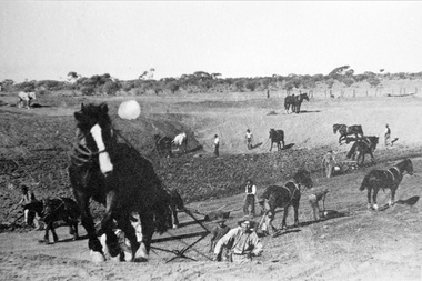
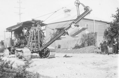
Photograph, Black & White Horse drawn scoops earthwork in Moorabbin Shire c1900, c1900
The, horse drawn metal scoop ,guided by a man, was used to clear earth for road making. Well before the introduction of motorised, mechanical graders and trucks the painstaking, labour-intensive work was undertaken by large teams of sturdy men using strong horses such as the draught horse. Roads were needed by the market gardeners to transport their produce to market. Later as the heavy wagon loads continually caused ruts and general degradation of the roadways a Plateway system was installed so that the wagon wheels could roll along the rails thus protecting the roadways. August 31st 2021 Ron Nash, from WA, informs us "The men and horses pulling earth scoops in the photo are not moving earth for road making - they are excavating an "earth tank", or dam, as described in common nomenclature today. This skill was known as "tank sinking", and tank sinkers were active in many rural and remote areas in the 1800's and early 1900's, establishing sizeable dams for important water reserves for community and farm and railway use. With the advent of mechanised equipment such as bulldozers, the trade of tank sinking was still carried out, but on a faster basis. I am a former tank sinker and earth moving contractor, now long retired." Early settlers in Moorabbin Shire had to build the roads, plateways, drains, as the settlement of the land, in Dendy's Special Survey 1841 Brighton, spread and market gardeners need to transport their produce to market. Their most valuable possession was the draught horse that was used for ploughing, drawing carts and these scoops.Black & White photograph showing many horses pulling metal scoops guided by men to move earth for road making in Moorabbin Shire c 1900Back Handwritten Informationplateway, roadworks moorabbin shire, draught horses, metal scoops, paviers, box alonzo, smith j l; chaff cutter, horse drawn carts, toll gates brighton, motor cars 1900, steam engines, early settlers, bentleigh, mckinnon, parish of moorabbin, city of moorabbin, county of bourke, moorabbin roads board, shire of moorabbin, henry dendy's special survey 1841, were j.b.; bent thomas, o'shannassy john, king richard, charman stephen, highett william, ormond francis, maynard dennis, market gardeners, vineyards, orchards -
 Greensborough Historical Society
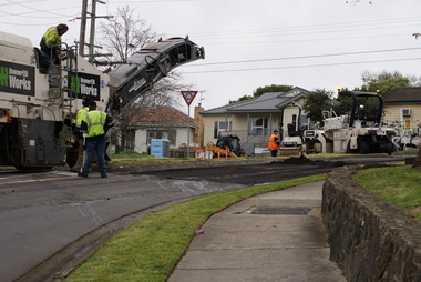
Photograph - Digital image, Jasmin Burge, Works on Nell Street roundabout August 2011: group of 6 photographs, 15/08/2011
Works on the Nell Street Greensborough roundabout, August 2011. Group of 6 photographs showing road workers completing an upgrade to the roundabout. Photographs taken by GHS member Jazz Burge.Digital copy of colour photograph.nell street, roadworks -
 Greensborough Historical Society
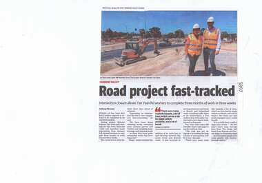
Newspaper Clipping, Diamond Valley Leader, Road project fast-tracked, 30/01/2019
Stage 1 of Yan Yean Road's $131.2 million upgrade is on track to be completed by its mid 2019 deadline.News article 1 page, black text.yan yean road, yan yean, traffic, roadworks -
 Greensborough Historical Society
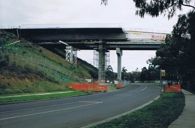
Photograph - Digital image, Frank Solomon, Plenty River Drive Bridge Roadworks 1, 1995c
These photos show the duplication of the bridge over Plenty River Drive on the Greensborough Bypass, circa 1995.Digital copy of colour photographplenty river drive, greensborough bypass -
 Greensborough Historical Society
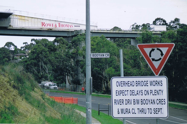
Photograph - Digital image, Frank Solomon, Plenty River Drive roadworks 2, 2005c
These photos show the duplication of the bridge over Plenty River Drive on the Greensborough Bypass, circa 2005.Digital copy of colour photographplenty river drive, greensborough bypass -
 Greensborough Historical Society
Photograph - Digital image, Frank Solomon, Plenty River Drive Bridge Roadworks 3, 2005c
These photos show the duplication of the bridge over Plenty River Drive on the Greensborough Bypass, circa 2005.Digital copy of colour photographplenty river drive, greensborough bypass -
 Greensborough Historical Society
Photograph - Digital image, Frank Solomon, Plenty River Drive Bridge Roadworks 4, 2005c
These photos show the duplication of the bridge over Plenty River Drive on the Greensborough Bypass, circa 2005.Digital copy of colour photographplenty river drive, greensborough bypass -
 Ringwood and District Historical Society
Photograph, Roadworks excavator - 1930s style
Black and white photograph of excavator. (2 copies) -
 Orbost & District Historical Society
black and white photographs, C1975
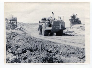
These four photographs show the construction of the Princes Freeway on the eastern edge near the cemetery. of the Orbost township. The road is from the eastern entrance to the cemetery.These photographs are pictorial records of the construction of roads in Orbost.Four black / white photographs of road construction machinery.road-construction-orbost roadwork-orbost-cemetery -
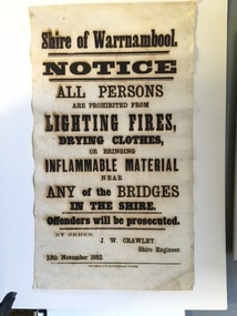 Warrnambool and District Historical Society Inc.
Document, Shire of Warrnambool Fire - Washing-Bridge 1882, 1882
This notice relates to the prohibition of lighting fires,drying clothes or bringing inflamable material near any of the bridges in the shire. Offenders will be prosecuted. With a date of 1882 and the fact that bridges were mostly made of wood, it would have been of concern that the destruction of bridges was not only of great inconvenience but also of considerable expense. But the reality of bridges providing shelter and warmth in the colder months and the ensuring fires and burnt bridges has more than likely precipitated this notice. J W Crawley was shire engineer from 1876 until 1895 and for 10 of those years he trained his son J W Crawley who succeeded his father and served in the position for 40 years.He in turn was succeeded by his son Rolf Crawley in 1935. In 1963 the bridge over the Hopkins Falls at Wangoom was named the Crawley bridge in honour of service to the Shire of Warrnambool by members of the Crawley family. The Shire of Warrnambool was proclaimed in 1863 and covered an area of over 600 square miles. Much of it was incorporated into the Moyne Shire in the 1990's with some being included into the boundaries of City of Warrnambool. This banner is an interesting piece of history. It shows the issues confronting early settlers such as shelter and the chores of daily life but also the importance placed on infrastructure which was slowly taking place around the district. It was in the era of drainage and roadworks and hence bridges were an important part of that infrastructure. The name J W Crawley is one of importance in the Warrnambool district for his service over many years. Rectangular piece of cloth printed in black ink. The back is plain.Shire of Warrnambool By order of J W Crawley Shire Engineer, 13th November 1882. Thos Smith gas Printing Works Koroit Street Warrnambool.warrnambool, shire of warrnambool, bridges of warrnambool shire, j w crawley, warrnambool shire engineer, crawleys of warrnambool -
 Kew Historical Society Inc
Journal, Kewriosity : November 1989
Paper collections / p1. Community Assistance Grants / 1. Stop Press [Community Services Department, Planning and Development Department] / p1. Dates for November / p2. Residential policies review / p2. Cotham/Glenferrie traffic plans / p2. Christmas cards / p2. And more Christmas cards / p2. History tapestry nears completion [bicentennial project, Kew Historical Society] / p2. Commentary / Cr Michael Montalto [Council finances] / p3. Municipal Offices temporarily relocate [asbestos] / p3. Osteoporosis apparatus installed at St George's [Hospital] / p4. Camberwell joins holiday program [Teenage Holiday Program] / p3. Notices / p4. Early parenting / p4. Roadworks for Kew / p4. Where are you Clark Kent? [Interchange Inner East] / p5. Bushwalkers clean up [Studley Park] / p5. [St George's] Hospital signs first health agreement / p5. [Royal Women's] Hospital honours work of Kew women / p6. Council waste disposal costs up 30% / p6. Merri Yarra [Municipal Protection] Committee disbands / p6. Keeping you informed [Citizens' Advice Bureaux] / p7. Overdevelopment review put on hold / p7. Kew's Parks - Is there room for improvement / p7. [Woodlands Avenue] Playgroup enrolments open / p7. Neighbourhood Watch / p8. Bowls at East Kew [Kew East Bowling Club] / p8. [Kew Bowling Club] / p8. Kew brothers rowed for gold [Bradley Kinninmonth, Eugene Kinninmonth] / p8.Kewriosity was a local newsletter combining Kew Council and community news. It was published between November 1983 and June 1994, replacing an earlier Kewriosity [broad] Sheet (1979-84). In producing Kewriosity, Council aimed to provide a range of interesting and informative articles covering its deliberations and decision making, together with items of general interest and importance to the Kew community and information not generally available through daily media outlets.non-fictionPaper collections / p1. Community Assistance Grants / 1. Stop Press [Community Services Department, Planning and Development Department] / p1. Dates for November / p2. Residential policies review / p2. Cotham/Glenferrie traffic plans / p2. Christmas cards / p2. And more Christmas cards / p2. History tapestry nears completion [bicentennial project, Kew Historical Society] / p2. Commentary / Cr Michael Montalto [Council finances] / p3. Municipal Offices temporarily relocate [asbestos] / p3. Osteoporosis apparatus installed at St George's [Hospital] / p4. Camberwell joins holiday program [Teenage Holiday Program] / p3. Notices / p4. Early parenting / p4. Roadworks for Kew / p4. Where are you Clark Kent? [Interchange Inner East] / p5. Bushwalkers clean up [Studley Park] / p5. [St George's] Hospital signs first health agreement / p5. [Royal Women's] Hospital honours work of Kew women / p6. Council waste disposal costs up 30% / p6. Merri Yarra [Municipal Protection] Committee disbands / p6. Keeping you informed [Citizens' Advice Bureaux] / p7. Overdevelopment review put on hold / p7. Kew's Parks - Is there room for improvement / p7. [Woodlands Avenue] Playgroup enrolments open / p7. Neighbourhood Watch / p8. Bowls at East Kew [Kew East Bowling Club] / p8. [Kew Bowling Club] / p8. Kew brothers rowed for gold [Bradley Kinninmonth, Eugene Kinninmonth] / p8. publications -- city of kew (vic.), kewriosity, council newsletters, community newsletters -
Malmsbury Historical Society
Photograph (Item), Roadworks At Evans St Malmsbury C2000, Malmsbury c2000
Associated with - "Mhs, Mrsc?" Buildings - "Station, Evans St" -
Malmsbury Historical Society
Photograph (Item), Roadworks At Evans St Malmsbury C2000, Malmsbury c2000
Associated with - "Mhs, Mrsc?" Buildings - Bus Shelter -
Malmsbury Historical Society
Photograph (Item), Roadworks At Evans St Malmsbury C2000, Malmsbury c2000
Associated with - "Mhs, Mrsc?" Buildings - Houses -
Kew Historical Society Inc
Journal, Kewriosity : July 1984
Street trees in Kew [Carol Frank-Mas & Associates, Landscape Architects Report] / p1. Community [Gamblers Annymousl Action Programme; Save the Children Fund; Kew Garden Club; Native Plant Group; Kew Baptist Church; Hyde Park Fellowship; Film afternoon; Toy Library; Kew Junction Traders - advertising] / p2. Raoul Wallenberg Gardens / p3. Kew Recreation Centre / p3. Kew Historical Society / p3. Kew Community House / p4. Youth Pages [New Youth Centre for Kew; Unemployed? / p5. International Youth Year 1985 [What is it? So..., In Kew! Plans] / p6-7. [Youth] Talkback / p7. Things to do in Kew [&] A bit further afield [Kew Drop-in; After school activities; The Gap; Teen Club; Community House] / p8. Mayoral Comment - "Villa Alba" / Cr Jill O'Brien [Mayor of Kew] / p9. Community Directory updates / p9. Sahara Yoga [Centre] / p10. Community artists / p10. Highbury Grove Playgroup / p10. Kew Senior Citizens' Centre / p10. Powerlines and street trees / p11. Kindergarten enrolments / p11. Immunisation sessions / p11. Roadworks / p11. Drivers needed [Kew Community Bus] / p11. Domestic noise / p11. C.A.B. [Citizens' Advice Bureau] / p11. Kew (Daytime) Garden Club / p11. Kew people for nuclear disarmament / p11. H.K.C. Activities Centre / p11. Children's Services in Kew [Occasional Care Centre; Children's Services Officer; Full-Time Day Care Centre; Three Year Old Kindergarten; After School Programme; Extended Hours Kindergarten] / p12.Kewriosity was a local newsletter combining Kew Council and community news. It was published between November 1983 and June 1994, replacing an earlier Kewriosity [broad] Sheet (1979-84). In producing Kewriosity, Council aimed to provide a range of interesting and informative articles covering its deliberations and decision making, together with items of general interest and importance to the Kew community and information not generally available through daily media outlets.non-fictionStreet trees in Kew [Carol Frank-Mas & Associates, Landscape Architects Report] / p1. Community [Gamblers Annymousl Action Programme; Save the Children Fund; Kew Garden Club; Native Plant Group; Kew Baptist Church; Hyde Park Fellowship; Film afternoon; Toy Library; Kew Junction Traders - advertising] / p2. Raoul Wallenberg Gardens / p3. Kew Recreation Centre / p3. Kew Historical Society / p3. Kew Community House / p4. Youth Pages [New Youth Centre for Kew; Unemployed? / p5. International Youth Year 1985 [What is it? So..., In Kew! Plans] / p6-7. [Youth] Talkback / p7. Things to do in Kew [&] A bit further afield [Kew Drop-in; After school activities; The Gap; Teen Club; Community House] / p8. Mayoral Comment - "Villa Alba" / Cr Jill O'Brien [Mayor of Kew] / p9. Community Directory updates / p9. Sahara Yoga [Centre] / p10. Community artists / p10. Highbury Grove Playgroup / p10. Kew Senior Citizens' Centre / p10. Powerlines and street trees / p11. Kindergarten enrolments / p11. Immunisation sessions / p11. Roadworks / p11. Drivers needed [Kew Community Bus] / p11. Domestic noise / p11. C.A.B. [Citizens' Advice Bureau] / p11. Kew (Daytime) Garden Club / p11. Kew people for nuclear disarmament / p11. H.K.C. Activities Centre / p11. Children's Services in Kew [Occasional Care Centre; Children's Services Officer; Full-Time Day Care Centre; Three Year Old Kindergarten; After School Programme; Extended Hours Kindergarten] / p12. publications -- city of kew (vic.), kewriosity, council newsletters, community newsletters -
Kew Historical Society Inc
Journal, The Kewriosity Sheet Vol.1 No.7 : December 1979
What's doing in Kew for December / p1. Kew Elder Citizens [Members; The building; Activities; The Choir; Over 80s; Opportunity Shop; Outings; Supervisor; "For Friends of the Aged"] / Gwlad Wade p1. Your news s good news / p1. Village without a name [Edgevale Road] / Barbara Giles p2. Kew Joggers Group / p2. Kinder contributes to the International Year of the Child [Davis Street Kindergarten] / p2. Christmas Church Services / p2. Australian Kite Association / Helen Bushell p2. A.R.A.F.E.M.I. - A new association for Victoria [Association of Relatives and Friends of the Emotionally and Mentally Ill] / p2. Other meetings of local interest / p2. Council News [Roadworks for the year; Municipal Offices - Access for the disabled; Parks and recreations areas; Human Services; Christmas Holiday Programme] / p2. Kew Croquet Club / p2.The Kewriosity Sheet (1979-83) was first published in the City of Kew (Victoria) in June 1979 as a two-sided 'community newssheet'. It aimed to: 'share news about Kew happenings and Kew people, and to exchange ideas about living in Kew'. Later issues gradually evolved into a 4-page, quarto sized publication. The Kewriosity Sheet was superseded by the Kew Council publication 'Kewriosity' (1983-1994).non-fictionWhat's doing in Kew for December / p1. Kew Elder Citizens [Members; The building; Activities; The Choir; Over 80s; Opportunity Shop; Outings; Supervisor; "For Friends of the Aged"] / Gwlad Wade p1. Your news s good news / p1. Village without a name [Edgevale Road] / Barbara Giles p2. Kew Joggers Group / p2. Kinder contributes to the International Year of the Child [Davis Street Kindergarten] / p2. Christmas Church Services / p2. Australian Kite Association / Helen Bushell p2. A.R.A.F.E.M.I. - A new association for Victoria [Association of Relatives and Friends of the Emotionally and Mentally Ill] / p2. Other meetings of local interest / p2. Council News [Roadworks for the year; Municipal Offices - Access for the disabled; Parks and recreations areas; Human Services; Christmas Holiday Programme] / p2. Kew Croquet Club / p2. community publications --- kew (vic.), the kewriosity sheet, newsletters - kew (vic.) -
Whitehorse Historical Society Inc.
Article, Roadworks to be finished in May, 1991
Duplication of Boronia Road due to be completed (photo).Duplication of Boronia Road due to be completed (photo).Duplication of Boronia Road due to be completed (photo).gardiner, bob, boronia road, vermont -
 Eltham District Historical Society Inc
Negative - Photograph, Eltham Shire Council, Unidentified road, Eltham district, c.1985
One of a series of images on roll of film shot by Eltham Shire Council officers focussing on road and street infrastructure maintenance and upgrades and new rollover kerb and channel profilesRoll of 35mm colour negative film, 4 stripsKodak CP100 5094infrastructure, road construction, road drainage, road sealing, roadworks, shire of eltham, streets, streetscape