Showing 510 items
matching settlement in victoria
-
 Warrnambool and District Historical Society Inc.
Publication, Collett and Bain, Heytesbury Forest School, c.1971
This booklet, by Rosamund Duruz, gives the history of the schools in the Heytesbury Forest area. The Heytesbury Shire Council was established in 1863 and the first schools in the area opened in the 1870s. Most of them were closed when Timboon Consolidated School (later Timboon High School) opened in 1948. The Heytesbury Forest was largely deforested by the Bailey Closer Settlement Scheme of the 1930s and later the establishment of more farming properties in the 1950s. This booklet is of interest as a comprehensive history of the schools in the Heytesbury Forest area pre 1970. It will be useful for researchers. This is a soft-cover booklet of 63 pages. The cover is a cream colour with brown images of trees and a school on the front cover. The booklet includes a map, a sketch and several black and white photographs. The booklet is bound with metal staples.schools in heytesbury forest, victoria, rosamund duruz, historian, history of warrnambool -
 Warrnambool and District Historical Society Inc.
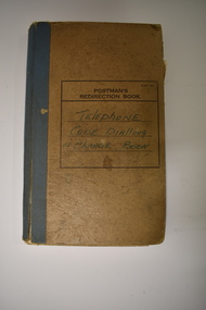
Notebook, Telephone Code Dialling & Change Book, Mid 20th century
This notebook has been used in the Nullawarre Post Office in the mid 1900s. It lists the telephone exchange codes of places in Victoria and also the code for the telephone charges to those places. Charles and Vida Williams were the Post Master and Post Mistress at Nullawarre Post Office during the mid 20th century years. Nullawarre is a small settlement 25 kilometres south east of Warrnambool and is mainly an agricultural area. European settlement first occurred in the late 1860s. This notebook is of some interest as one used in the day-to-day business of the Nullawarre Post Office in the mid 20th century.This is a notebook which was originally set up as a Postman’s Redirection Book but has been used to list alphabetically telephone exchange areas and their codes. The book has an alphabetical index on the side of the pages and printed black lines and hand-ruled lines on the pages. The cover is light brown with blue binding on the spine and the binding is partly giving way. There is black printing and handwritten writing on the front cover. The material on the pages is handwritten in blue ink and pencil. There is a blue stamp and some pieces of paper pasted into some pages. ‘Postman’s Redirection Book’ ‘Telephone Code Dialling & Charge Book’ ‘Nullawarre’ -
 Warrnambool and District Historical Society Inc.
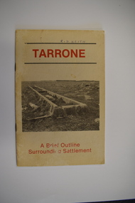
Booklet, Tarrone, 1983
A brief outline of the history of the Tarrone estateThis is a booklet of 20 pages. It has a buff-coloured cover with two black and white photographs and red print. The pages contain black and white photographs, printed text, maps and illustrations. The booklet is stapled non-fictionA brief outline of the history of the Tarrone estatesoldier settlements post world war two, tarrone estate -
 Eltham District Historical Society Inc
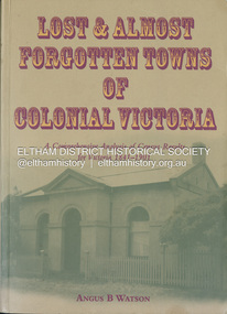
Book, Angus B. Watson, Lost & almost forgotten towns of colonial Victoria : a comprehensive analysis of census results for Victoria, 1841-1901, 2003
Lists all towns and villages with entries in the Victorian censuses between 1841 and 1901. It includes in excess of 1400 entries with the latitude and longitude for each town, numbers males and females in the town, and the number of occupied dwellings (where available). For many of these settlements the only visible trace of them today is in the census results collected by the fledgling governments of Colonial Victoria. It is a comprehensive reference and a fascinating insight into the movements of early populations of new Australians.cities and towns victoria, history 19th century, statistics, ghost towns - victoria, geographical names victoria, victoria census -
 Eltham District Historical Society Inc
Photograph - Digital Photograph, Alan King, St Margaret's Anglican Church, Pitt Street, Eltham, 30 January 2008
St Margaret’s Church of England was officially opened on December 12, 1861. It is the oldest intact church building in Eltham. At the time it was known as Christ Church until its consecration in 1871, when it was completely free of debt (£1,700 for the church and parsonage) despite the district’s poverty. This was largely due to the free labour and materials, including locally made bricks donated by local artisans and others. The church is historically significant because it is the oldest church in the former Shire of Eltham and has associations with the philanthropist and founder of Brighton, Henry Dendy (who donated the land on which the church is built), the architect Nathaniel Billing and the prominent local builder, George Stebbing. The church is architecturally and aesthetically significant because it is constructed in the Gothic Revival style with several stained-glass windows of various dates and is also a very early use of polychromatic brickwork in Victoria. Billing was one of the first Melbourne architects to employ polychromatic brickwork and an important early architect. The rear wall was intended to be temporary. A major feature of the design is the large buttresses with long, steeply graded upper faces. The overall design is well proportioned with the surface brick patterns relieving an otherwise austere design. The church is spiritually and socially significant because it has been an important place of worship for the people of Eltham for almost 150 years. The land on which the buildings stand was donated by Henry Dendy. Dendy arrived in Melbourne in 1841 after purchasing in England eight square miles at Brighton under the system of "special surveys". After this land passed out of his hands, Dendy moved about Victoria, visited England, then returned to settle in Eltham where he purchased a flour mill. Dendy chaired the meeting held in 1860 “for the purpose of devising such means as may be expedient for the establishment of a Church of England in the township of Eltham”. He became chairman and treasurer of the church committee. Unlike the establishment of many early churches in Victoria where a vicar was appointed to a parish and later a permanent church was constructed, the population at Eltham initiated action to build a church. The nearest church at that time was at Heidelberg and the Eltham settlement was part of the parish of St Johns Heidelberg. Isolation and the tedious, time consuming journey between Heidelberg and Eltham resulted in the Eltham community taking its own action. The original vicarage (Dendy House) at the rear of the church is also an important part of the cultural significance of this place because it is connected to the church and the development of the Eltham area. Together, the church and the vicarage are aesthetically significant because they form a significant streetscape feature. The mud-brick community hall designed by Robert Marshall was added in 1978. In 2014 the original temporary rear wall was removed as part of a modern extension designed by Architects Atelier Wagner and constructed by Conrad Construction and Management. Covered under Heritage Overlay, Nillumbik Planning Scheme. National Trust of Australia (Victoria) State significance Victorian Heritage Published: Nillumbik Now and Then / Marguerite Marshall 2008; photographs Alan King with Marguerite Marshall.; p67This collection of almost 130 photos about places and people within the Shire of Nillumbik, an urban and rural municipality in Melbourne's north, contributes to an understanding of the history of the Shire. Published in 2008 immediately prior to the Black Saturday bushfires of February 7, 2009, it documents sites that were impacted, and in some cases destroyed by the fires. It includes photographs taken especially for the publication, creating a unique time capsule representing the Shire in the early 21st century. It remains the most recent comprehenesive publication devoted to the Shire's history connecting local residents to the past. nillumbik now and then (marshall-king) collection, eltham, st margaret's anglican church, st margaret's church, christ church -
 Eltham District Historical Society Inc
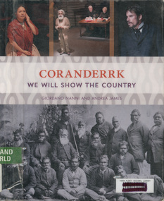
Book, Giordano Nanni et al, Coranderrk; We will show the country, 2013
Comprises twenty-three extracts from the Minutes of Evidence of the Coranderrk Inquiry, accompanied by an analysis of the historical text and context. The book relies strongly on primary-source materials and accurately references historical analysis from scholarly and Aboriginal perspectives. This book is derived from a verbatim-theatre performance in which professional actors portrayed the witnesses who gave evidence before the 1881 Coranderrk Inquiry.; Inscriptions and Markings: illustrations, photographs, facsimiles, maps, portraits About the book One of the first sustained campaigns for justice, land rights and self-determination in colonial Australia was undertaken by the Aboriginal people of Coranderrk reserve in central Victoria. Despite having created an award-winning farm they were targeted for removal to make way for white settlement. As skilled communicators and negotiators, they lobbied the government, in alliance with their white supporters, and succeeded in triggering a Parliamentary Inquiry in 1881. Coranderrk – We Will Show The Country derives from a unique verbatim-theatre performance where professional actors brought to life the witnesses who gave evidence before the 1881 Parliamentary Coranderrk Inquiry. Rescued from dusty archives, and including renowned Wurundjeri leader, William Barak, those witnesses continue to speak to contemporary audiences. Here, their powerful petitioning can be read alongside that of their non-Aboriginal allies, and those who would move them off their land. The book features a concise and accessible history of the Coranderrk Aboriginal Station and of the events that led to the appointment of the 1881 Parliamentary Coranderrk Inquiry. The book also contains a special edition of the verbatim script which has been annotated and referenced so as to provide a blueprint of how the original minutes of evidence from the 1881 Parliamentary Coranderrk Inquiry were adapted into a theatre script. Each scene of the play has also been introduced with a short biography of each character and a discussion of the key themes raised in their testimony. Supplementing the verbatim script of the performance, the book includes a range of historical images and stills from the ILBIJERRI Theatre Company’s production. Coranderrk – We Will Show The Country celebrates the spirit of collaboration between black and white in pursuit of justice, and offers an engaging way to learn about our past – and to think about our future. Coranderrk - We Will Show The Country. (2023, October 19). Retrieved from http://www.minutesofevidence.com.au/education/coranderrk-we-will-show-the-country-book/Ex Yarra Plenty Regional Library copyaboriginal australians, coranderrk, first nations people, healesville, indigenous history, performance, play -
 Marysville & District Historical Society
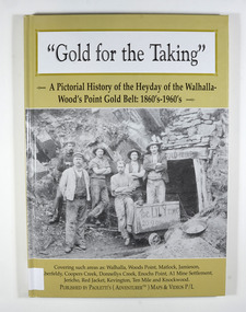
Book - Hardcover book, Gold for the Taking-A Pictorial History of the Heyday of the Walhalla-Wood's Point Gold Belt: 1860's-1960's, 2007
A pictorial history of the heyday of the Walhalla-Wood's Point gold belt in the 1860's-1960'sHardcover. The cover is a gold colour. The front cover has a photograph of a group of miners in front of the entry to a mine. On the top entry timber piece is a sign saying "Old Mine". The beginning of the wording is obscured by one of the miners standing in front of the entry. There is also an old mining trolley standing on tracks which lead into the mine.There is also an old gold mining dish sitting on a rock to the left of the entry into the mine.On the back cover is a photograph of Walhalla in modern times as well as a photograph of the publisher of this book. There is also a blurb about the publisher.Stamp of the Marysville & District Historical Society Inc / P.O. Box 22 / Marysville 3779gold, gold fields, gold mining, a1 mine settlement, aberfeldy, beardmore, black river group, coopers creek, donnellys creek, enochs point, fulton creek, gaffneys creek, gooleys creek, jamieson, jordan valley, kevington, knockwood, matlock, ten mile, walhalla, wood's point, history, victoria -
 Marysville & District Historical Society
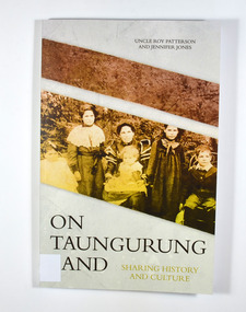
Book, Jennifer Jones et al, On Taungurung Land-Sharing History and Culture, 2020
... aboriginal station central victoria history white settlement ...On Taungurung Land: Sharing History and Culture is the first monograph to examine how the Taungurung Nation of central Victoria negotiated with protectors and pastoralists to retain possession of their own country for as long as possible.Front cover has a photograph of the Patterson family c.1904. Back cover has the blurb of the book and information about the authors of the book.non-fictionOn Taungurung Land: Sharing History and Culture is the first monograph to examine how the Taungurung Nation of central Victoria negotiated with protectors and pastoralists to retain possession of their own country for as long as possible.taungurung nation, elder uncle roy patterson, jennifer jones, acheron aboriginal station, mohican aboriginal station, central victoria, history, white settlement -
Federation University Historical Collection
Book, Frank Hurley, An Event That Never Happened: The history and politics of decentralisation in Victorian and New South Wales 1885-1985 (Thesis), 1989
This thesis is an account of movements and policies for decentralisation of population and economic activity away from metropolitan to non-metropolitan areas in Victoria and New South Wales between 1885 and 1985. Red hard covered thesis undertaken for a Doctory of Philosphy ot the University of Melbourne. frank hurley, thesis, doctorate, decentralisation, ppoulation, economics, policy, closer settlement acts, urbanisation, decentralisation league, war and reconstruction, central planning, town planning, victorian decentralisatoin league, owen paper mill, slough estate, noel mobbs, ballarat common, edgar bartrop, australian paper mills, bendix mintex, ball, ballarat development committee -
 Marysville & District Historical Society
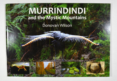
Book, Donovan Wilson, Murrindindi and the Mystic Mountains, Post 2009
A book of photographs of natural attractions, flora and fauna taken in and around the Murrindindi Shire.Paperback. Front cover has a large photograph of a lyrebird in full song. Along the lower edge of the front cover are four photographs; a Spotted March frog, the Gould Memorial Drive, a river and a wombat. Back cover has a photograph of the Cathedral Range at dawn.non-fictionA book of photographs of natural attractions, flora and fauna taken in and around the Murrindindi Shire.murrindindi, victoria, landmarks, flora, fauna, waterfalls, rivers, nature, natural attractions -
 Bendigo Military Museum
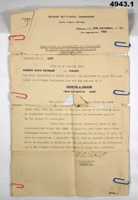
Certificate, Certificate of eligibility and suitability for soldier settlement
1. Foolscap size sheet (see condition) Letterhead is for the soldier Settlement Commission. State Public Offices. Tel F 0234. Dated Melb 16 Sep 1947. Letter No 8945. In the text is Cert No. 4677 for Kenneth Edwin Beckman of Cowangi. The purpose of the land is for cropping and grazing (non irrigation land) 2. Letter quarto size paper. Letterhead of Australian Mil Forces. Tel No. M 45966 Ext 30. Victoria Echelon and records 291 Lonsdale St Melbourne dated 2 Nov 1945. In the text is printed EX V64354 K E Beckman. Cert of Discharge 294425. RAS Badge No. A 99448. Will (AAF A.131) One..admin record, ww2 -
 Lara RSL Sub Branch
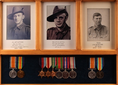
Photographs, Bob Wilson, Framed Photos and Medals - McIntyre Family, 2016
These photographs and medals are of the McIntyre family. Three members of Lara's McIntyre family served during the First and Second World Wars, and two were members of the Lara RSL. John Lachlan McIntyre was born at Beeac, Victoria in December 1890. He enlisted in the 1st AIF in July 1915. John fought on the Western Front, taking part in the battles of Fromelles and the 2nd Battle of the Somme. He was severely wounded at Fromelles and spent 12 months in hospital in England before returning to the front. John returned home in 1919 and was granted a soldier settlement block in Lara in 1937. He was a founding member of Lara RSL and is its longest serving member. John died in 1990. Thomas Gordon McIntyre was born at Lara in 1901. Thomas, known as Gordon, was too young to enlist in the First World War with his brothers. At the outbreak of the Second World War he joined the 2/2nd Pioneer Battalion. He fought in the Syrian Campaign, before being recalled to Australia to fight in the pacific campaign. Gordon was wounded in a battle against the Japanese in Java on the 19/02/1942, and taken prisoner. No record of him after this was ever discovered, and he is presumed to have been killed. Jim McIntyre was born in 1893, and grew up in Lara and Geelong. Jim enlisted in the 1st AIF in 1916, and served with the 14th Battalion through the war. He was wounded twice. Jim died in 1976. The McIntyre family were early pioneers in the Lara district, and the brothers were founding members of the Lara RSL. Their medals and photographs represent a significant link to the history of the town and sub-branch. Three photographs and three sets of medals in a pine wood frame with glass covering. Photographs are black and white portraits of soldiers in uniform mounted on cream card. The medals are mounted on black felt. T.G. McIntyre VX20754 - 35-45 Star, Africa Star, Pacific Star, Defence Medal, War Medal and the Australian Service Medal 39-45. J.L. McIntyre 3591 - War Medal and Victory Medal J.W. McIntyre 7049 - War Medal and Victory Medal J.L. McIntyre REG. No. 3591 58th. BATT. 1st A.I.F Foundation Member Lara R.S.L 1890 - 1990 REG. NO. VX20754 T.G. MC INTYRE 2/2nd PIONEERS 2nd A.I.F 7049 J.W. McINTYRE 14th BTN. 1893-1975photograph, mcintyre, medals, wwi, wwii, world war 1, world war 2, aif, pioneers, lara, rsl -
 Lara RSL Sub Branch
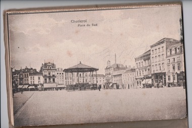
Postcards, France
John Lachlan McIntyre was born at Beeac, Victoria in December 1890. He enlisted in the 1st AIF in July 1915. John fought on the Western Front, taking part in the battles of Fromelles and the 2nd Battle of the Somme. He was severely wounded at Fromelles and spent 12 months in hospital in England before returning to the front. John returned home in 1919 and was granted a soldier settlement block in Lara in 1937. He was a founding member of Lara RSL and is its longest serving member. John died in 1990. This letter was written by John and sent to his mother in 1918 on his journey through Belgium. The McIntyre family were early pioneers in the Lara district, and the brothers were founding members of the Lara RSL. This letter represents a significant link to the history of the town and sub-branch.A brown envelope addressed to Miss J McIntyre. Within the envelope is a pack of 12 illustrated souvenir post cards. Envelope: O.A.S. Tower of London. Miss J McIntyre. Elcho Lara lake, Australia, Victoria. Rear of postcard pack: London December 27th 18 Dear Mother, I arrived here yesterday. Spent Xmas day travelling across France. The trip took the best part of four days. We are up near Belgium. Had to go into Belgium to get a train. Will write when I get settled. Hoping you are all well. With best wishes for a happy new year. Jack. Edition Martinetty Charleroi Front of pack: J. L. McIntyre Xmas 1918 Souvenir de Charleroi-Belgium 12 cartes postales 12 En Photochrommother, letter, postcard, first world war, wwi, world war one, belgium, lara -
 Federation University Historical Collection
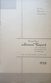
Booklet - Annual Report, Greater Ballarat Association Annual Report 1952-1974, 1952-1974
The first presedent of the Greater Ballarat Association in 1938 was Robert J. Cooke. Eighteen annual reports of the Greater Ballarat Association. Each one discussed the work of the association and lists the subscribers. greater ballarat association, annual report, edgar bartrop, g.b. richmond, a.w. nicholson, g.e. deeble, r.g> caddell, l.j. fraser, t.u. haymes, a.w. lynch, keith rash, tourist bureau, botanical gardens telepone booth, pryor park tree planting, ballarat zoological gardens, centenary window dressing competition, soldier settlement, proposal for university for ballarat, caravan park, ballarat common, ballarat common development, t.t. hollway, housing commission, wendouree housing commission, industrial development, s.s. ballarat, begomia festiva, r.g. caddell, w.gordon smith, f.h. menzies, olympic rowing, royal tour decorations, begonia float, widening of railway bridge, j. chatham, l.g. chester, s.v. playsted, n. ellis, langi kal kal, langi kal kal training centre, migrants to victoria, flood lighting of the arch of victory, olympics holidays, ballarat's projected olympic pool, ballarat fish hatcheries, olympic hostel, town planning, murray byrne, titles for residence areas, service club signs, railway level crossing, traffic, ploughing competition, w. fraser, young australia league, removal of raaf from ballarat, renumbering of streets, renumbering of streets to the block system, miners' racecourse reserve, historical museum, ballarat historical society, c.m. canty, mavis canty, university status, ballarat university college, j.w. murray, p.r. gray, b.c. mcorist, n.c. ellis, w.h. heinz, save the lake campaign, lake wendouree, weed, home host scheme, b. walker, develop victoria council, eureka development, victorian decentralization league, r.h. ramsay, allan c. pittard, w. gordon smith, c.h. davis, b.c. hedgcock, les kennedy, p.j. rice, a.f. waddington, john p. cook, historic markers, maze, traffic lights, bungal dam, camera clubs, sunraysia way, map, centre of road parking, paddle steamer, wendouree apex, local government women's association, may nelson, wes sobey, melton foo, l.l. zilles, dulcie sullivan, m. barnes, lou zilles, john wesley sobey, e.r. ingles, herb warren, kryal castle -
 Flagstaff Hill Maritime Museum and Village
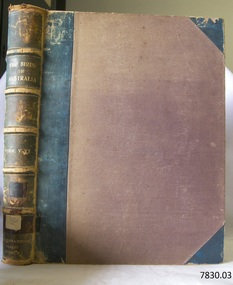
Book, The Birds of Australia Vol 3 - 4
The Work “The Birds of Australia; containing over 300 full-page illustrations, with a descriptive account of the life and characteristic habits of over 700 species” by Gracius J. [Joseph] Broinowski – Australian author, artist and ornithologist - was created in 40 parts for subscribers and sold for 10s [shillings]., These parts were later published in six volumes, which were later published and bound in pairs to make three volumes, each of which contain two of the six original volumes, numbered volumes, “I”, “III” and “V” on their fly page, but numbered “Vols. I-II”, “Vols. III-IV” and “Vols. V-VI” on their respective spines. The volumes were all published by Charles Stuart & Co. (Melbourne, Sydney, Adelaide, Brisbane, New Zealand, and Tasmania). All of the beautifully drawn and coloured illustrations in The Birds of Australia were illustrated by Broinowski. They were printed using a new 19th century method called chromolithography. This is the art of making multi-coloured prints. The skilled lithographer would work from an original coloured painting and create a copy for every one of the many layers of colour used to build the painting. These layers were then printed carefully over each other to re-build the picture. Gracius J. Broinowski’s Work “The Birds of Australia” was described by Jean.Anker as “a semi-popular but comprehensive treatment of the subject” in the book “Bird Books and Bird Art: an outline of the Literary History and Iconology of Descriptive Ornithology” 1979. It may be that these books were donated to, or ordered specifically for, the Warrnambool Public Museum, due to the embossing on the spine “WARRNAMBOOL PUBLIC LIBRARY”. The acquisition of these books would most likely to have made 1891-1910, between the date the books were published and the date that the Museum amalgamated with the Mechanics Institute, which then became part of The Museum and Art Gallery. These three books were part of the collection of books belonging to the Warrnambool Public Museum, established 1873 by Joseph Archibald. The Museum moved into the back of the Mechanics’ Institute in 1885, along with the Art Gallery and School of Dancing. In 1886 it was officially opened as The Warrnambool Museum and Art Gallery, with Joseph Archibald as its curator. In 1887 the Museum section was moved to the former court house in Timor Street, with Joseph Archibald as Curator until 1897. In 1910 the Museum was transferred back to the original building and the management of the Mechanics' Institute was handed over to the Warrnambool City Council. In 1935 Ralph Pattison was appointed as City Librarian. He developed his own sorting and cataloguing system and organised the collection of books accordingly. In the 1960’s the Warrnambool City Council closed down the Museum and Art Gallery and the books and artefacts were redistributed to other organisations in Warrnambool. Each spine of this book set, The Birds of Australia by Gracius Broinowski, shows a space on which a previous cataloguing label may have been affixed. The volumes are amongst the many books at Flagstaff Hill Maritime Village that display stamps and markings from Pattison as well as a variety of other institutions including the Mechanics’ Institute itself. Some other Australian Libraries also include these books in their collections; Australian National University, University of NSW, University of Western Australia, State Library of Western Australia, Deakin University, Queen Victoria Museum and Art Gallery, University of Adelaide, University of Queensland, University of Tasmania. The Library of Congress and the University of British Columbia also have sets of these volumes. These books are considered as Rare Book; a set of Broinowski’s 3 volumes was advertised in Melbourne’s Rare Book Fair 2012, “for ornithological collectors”. (See the more detailed information below in “Warrnambool Public Museum and Mechanics Institute” and the “Pattison Collection”.) GRACIUS JOSEP BROINOWSKI Gracius Joseph Broinowski (7/3/1837 – 11/4/1913), artist and ornithologist, was born in Walichnowy, Poland, son of a landowner and military officer of the same name. He was educated privately then later, at the Munich University, he was a student of languages, classics and art. To avoid conscription into the Russian army, he migrated to Germany. At the age of about 20 years he migrated to Portland (Victoria, Australia), working his passage as part of the crew of a windjammer. Broinowski worked in the country for a few years then found employment working for a Melbourne publisher and later sold his own paintings. In about 1863, while on one of his many travels in eastern Australia painting landscapes and scenes, he married Jane Smith in Richmond, Victoria (her father was captain of a whaler). In 1880 he settled in Sydney where his work involved teaching painting, lecturing on art and exhibiting his own work at showings of the Royal Art Society. Also in the 1880s he began to publish illustrated works on Australian natural history, including; - illustrations of the birds and mammals of Australia, commissioned by the Department of Public Instruction, New South Wales, and mounted, varnished and hung on walls in many classrooms - "The Birds and Mammals of Australia"; a bound collection of illustrations with appropriated text - 1888 "The Cockatoos and Nestors of Australia and New Zealand" - 1890-1891, "The Birds of Australia" Broinowski died in 1913 at Mosman, Sydney, survived by his wife, six sons and a daughter. His son, Leopold, became a significant political journalist in Tasmania. WARRNAMBOOL PUBLIC MUSEUM & MECHANICS INSTITUTE Warrnambool's Mechanics' Institute (or Institution as it was sometimes called) was one of the earliest in Victoria. On 17th October 1853 a meeting was held where it was resolved to request the Lieutenant Governor of the Colony to grant land for the erection of a Mechanics' Institutes building. A committee was formed at the meeting and Richard Osburne chaired the first meeting of this committee. The land on the North West corner of Banyan and Merri Streets was granted but there were no funds to erect the building. The Formal Rights of the Warrnambool Mechanics' Institute's encompassed its aims and these were officially adopted in1859; "This Institution has for its object the diffusion of literary, scientific, and other useful knowledge amongst its members, excluding all controversial subjects, religious or political. These objects are sought to be obtained by means of a circulating library, a reading room, the establishment of classes, debates, and the occasional delivery of lectures on natural and experimental philosophy, mechanics, astronomy, chemistry, natural history, literature, and the useful and ornamental arts, particularly those which have a more immediate reference to the colony." The Warrnambool Mechanics' Institute opened its first reading room in December 1854 in the National School building at the corner of Banyan and Timor Streets. The Institute was funded by member subscription, payable on a quarterly, half yearly or yearly basis. Samuel Hannaford, the Manager of the Warrnambool Bank of Australasia, was the first Honorary Secretary of the Mechanics' Institutes, and an early President and Vice-President. He also gave several of the early lectures in the Reading Room. Another early Secretary, Librarian and lecturer was Marmaduke Fisher, the teacher at the National School. Lecture topics included The Poets and Poetry of Ireland', 'The Birth and Development of the Earth', 'The Vertebrae - with Remarks on the pleasures resulting from the study of Natural History' and 'Architecture'. In 1856 the Reading Room was moved to James Hider's shop in Timor Street, and by 1864 it was located in the bookshop of Davies and Read. In the 1860's the Mechanics' Institute struggled as membership waned but in 1866, after a series of fund raising efforts, the committee was able to purchase land in Liebig Street, on a site then called Market Square, between the weighbridge and the fire station. A Mechanics' Institute building was opened at this site in August 1871. The following year four more rooms were added to the main Reading Room and in 1873 the Artisan School of Design was incorporated into the Institute. The same year, 1873, Joseph Archibald established the Warrnambool Public Museum [Warrnambool Museum], however it deteriorated when he was transferred to Bendigo in 1877. In 1880, with Archibald's return to Warrnambool, the Museum was re-established and he served as Curator 1882-1897. In 1885 a new building was added to the back of the Mechanics’ Institute to accommodate the re-created School of Design, the Art Gallery and the Museum. It was officially opened as the Warrnambool Museum and Art Gallery on 26th July 1886 with Mr Joseph Archibald as Curator. In 1887 the Museum section was moved to the former court house in Timor Street (for some time the walls of the building formed part of the TAFE cafeteria but all is now demolished). In 1910 the Museum was transferred back to the original building and the management of the Mechanics' Institute was handed over to the Warrnambool City Council. The Museum and Art Gallery became one and housed many fine works of art, and the Library continued to grow. The building was well patronised, with records showing that at the beginning of the 20th century there were between 500 and 800 visitors. During World War One the monthly figures were in the thousands, with 3,400 people visiting in January 1915. The Museum was a much loved Institution in Warrnambool until 1963 when the Museum and Art Gallery was closed and the contents removed to make room for the Warrnambool City Council Engineers' Department. The contents were stored but many of the items were scattered or lost. The Museum has never been re-opened. When the original building was demolished the site became occupied by the Civic Centre, which included the new City Library. (The library was temporarily located in the old Palais building in Koroit Street.) In the process of reorganisation the Collection was distributed amongst the community groups: -The new City Library took some of the historic books and some important documents, historic photographs and newspapers. -The Art Gallery kept the 19th Century art collection and some of the artefacts from the museum. -The Historic Society has some items -The State Museum has some items -Some items were destroyed -Flagstaff Hill Maritime Village has old newspapers, Government Gazettes, most of the Mechanics' Institute Library (which included books from the Warrnambool Public Museum), ledgers and documents connected to the Mechanics' Institute Library, some framed and unframed art works and some photographs. THE PATTISON COLLECTION These books “The Birds of Australia” by Broinowsky, are also listed as part of the ‘Pattison Collection’, a collection of books and records that was originally owned by the Warrnambool Mechanics’ Institute, which was founded in Warrnambool in 1853. In 1935 Ralph Pattison was appointed as City Librarian to establish and organise the Warrnambool Library, as the Warrnambool Mechanics’ Institute was then called. When the Warrnambool Mechanics’ Institute building was pulled down in 1963 a new civic building was erected on the site and the new Warrnambool Library, on behalf of the City Council, took over all the holdings of the Warrnambool Mechanics’ Institute. At this time some of the items were separated and identified as the ‘Pattison Collection’, named after Ralph Pattison. Eventually the components of the Warrnambool Mechanics’ Institute were distributed from the Warrnambool Library to various places, including the Art Gallery, Historical Society and Flagstaff Hill. Later some were even distributed to other regional branches of Corangamite Regional Library and passed to and fro. It is difficult now to trace just where all of the items have ended up. The books at Flagstaff Hill Maritime Village generally display stamps and markings from Pattison as well as a variety of other institutions including the Mechanics’ Institute itself. RALPH ERIC PATTISON Ralph Eric Pattison was born in Rockhampton, Queensland, in 1891. He married Maude Swan from Warrnambool in 1920 and they set up home in Warrnambool. In 1935 Pattison accepted a position as City Librarian for the Warrnambool City Council. His huge challenge was to make a functional library within two rooms of the Mechanics’ Institute. He tirelessly cleaned, cleared and sorted a disarrayed collection of old books, jars of preserved specimens and other items reserved for exhibition in the city’s museum. He developed and updated the library with a wide variety of books for all tastes, including reference books for students; a difficult task to fulfil during the years following the Depression. He converted all of the lower area of the building into a library, reference room and reading room for members and the public. The books were sorted and stored using a cataloguing and card index system that he had developed himself. He also prepared the upper floor of the building and established the Art Gallery and later the Museum, a place to exhibit the many old relics that had been stored for years for this purpose. One of the treasures he found was a beautiful ancient clock, which he repaired, restored and enjoyed using in his office during the years of his service there. Ralph Pattison was described as “a meticulous gentleman whose punctuality, floorless courtesy and distinctive neat dress were hallmarks of his character, and ‘his’ clock controlled his daily routine, and his opening and closing of the library’s large heavy doors to the minute.” Pattison took leave during 1942 to 1945 to serve in the Royal Australian Navy, Volunteer Reserve as Lieutenant. A few years later he converted one of the Museum’s rooms into a Children’s Library, stocking it with suitable books for the younger generation. This was an instant success. In the 1950’s he had the honour of being appointed to the Victorian Library Board and received more inspiration from the monthly conferences in Melbourne. He was sadly retired in 1959 after over 23 years of service, due to the fact that he had gone over the working age of council officers. However he continued to take a very keen interest in the continual development of the Library until his death in 1969. References: Archibald Street, Discover the History of Warrnambool Streets, https://www.warrnambool.vic.gov.au/sites/warrnambool.vic.gov.au/files/images/Property/roads/The%20story%20of%20Warrnambool's%20streets.pdf Broinowski, Bird Books and Bird Art etc, Jean Anker 1979, https://books.google.com.au/books?id=B5TpCAAAQBAJ&pg=PA66&lpg=PA66&dq=the+birds+of+australia,+broinowski,+bird+books+and+bird+art&source=bl&ots=nQroxqePdY&sig=a3lnn-_FqB-ZcFAwqRYVK6Y7ZeM&hl=en&sa=X&ved=0ahUKEwj5sL7-2JTSAhWIyLwKHaCHAJcQ6AEIUTAN#v=onepage&q=the%20birds%20of%20australia%2C%20broinowski%2C%20bird%20books%20and%20bird%20art&f=false Broinowski, Gracius Joseph, by A.H. Chisholm, Australian Dictionary of Biography http://adb.anu.edu.au/biography/broinowski-gracius-joseph-3061 Chromolithography, Wikipedia https://en.wikipedia.org/wiki/Chromolithography Document, Flagstaff Hill, ‘Mechanics’ Institute Collection’: Books on Dean, Melbourne Rare Book Fare 2015, BookFare Newsletter #5, www.anzaab.com/newsletters/BookFare_1207.pdf Flagstaff Hill archives; document “Re: Ralph Eric Pattison”] Gracius Broinowski, Wikipedia https://en.wikipedia.org/wiki/Gracius_Broinowski Gracius Joseph Broinowski, Design & Art Australia online, https://www.daao.org.au/bio/gracius-joseph-broinowski/biography/ Mechanics' Institutes of Victoria Pg ix, 283; Significance Assessment, Warrnambool Mechanics’ Institute Books, FHMV, 2010 The Birds of Australia by Gracius J. Broinowski, Libraries of Australia, Trove http://trove.nla.gov.au/work/12425131?q&sort=holdings+desc&_=1487246530281&versionId=210683608 The Birds of Australia, Broinowski; www.Librarything.com The History of Warrnambool, R. Osburne, 1887, p.72, p. 283 The Warrnambool Mechanics’ Institute – FHMV datasheet Warrnambool Art Gallery History, Warrnambool Art Gallery Foundation Information Booklet, http://www.wagf.com.au/cms/downloads/WAGF-Information-Booklet.pdf Warrnambool Museum and Art Gallery, The Argus, 29th July 1886 Web; The Birds of Australia (Broinowski), Wikipedia The Birds of Australia by Gracius J. Broinowski is a respected source of scientific information. It is also significant for its rarity and as an early Australian Work. The book is significant for its association with the Warrnambool Public Museum, which played an important educational and social role in the early settlement of Warrnambool and District. The book is also significant for its association with the Warrnambool Mechanics' Institute Library book collection, which is deemed to be of great importance because it is one of the few collections in an almost intact state, and many of the books are now very rare and of great value. The Warrnambool Mechanics’ Institute Collection is primarily significant in its totality, rather than for the individual objects it contains. Its contents are highly representative of the development of Mechanics' Institute libraries across Australia, particularly Victoria. A diversity of publications and themes has been amassed, and these provide clues to our understanding of the nature of and changes in the reading habits of Victorians from the 1850s to the middle of the 20th century. The Warrnambool Mechanics Institute book collection has historical and social significance for its strong association with the Mechanics Institute movement and the important role it played in the intellectual, cultural and social development of people throughout the latter part of the nineteenth century and the early twentieth century. The collection of books is a rare example of an early lending library and its significance is enhanced by the survival of an original collection of many volumes. The collection also highlights the Warrnambool community’s commitment to the Mechanics’ Institute, reading, literacy and learning in the regions, and proves that access to knowledge was not impeded by distance. These items help to provide a more complete picture of our community’s ideals and aspirations. The book is also significant for its inclusion in the Pattison Collection, a collection that as a whole shows a snapshot of the types of reading material offered to the local public at that point in time. The Birds of Australia Vol 3 - 4 Author and Illustrator: Gracius J Broinowski Publisher: Charles Stuart & Co Date: 1890Label on spine cover with typed text RA 598.2 BRO Pastedown front endpaper has sticker from Warrnambool Mechanics Institute and Free Library Embossing added to spine “WARRNAMBOOL PUBLIC MUSEUM” flagstaff hill, warrnambool, shipwrecked coast, flagstaff hill maritime museum, maritime museum, shipwreck coast, flagstaff hill maritime village, great ocean road, the birds of australia, gracius joseph broinowski, charles stuart & co, joseph archibald, warrnambool public museum, warrnambool museum, warrnambool library, warrnambool art gallery, warrnambool city librarian, pattison collection, ralph eric pattison, samuel hannaford, warrnambool mechanics’ institute and free library, mechanics’ institute library, victorian library board, warrnambool books and records, rare books, australian bird illustrations, australian bird text, australian natural history, the birds of australia vol 3 - 4 -
 Flagstaff Hill Maritime Museum and Village
Book, The Birds of Australia Vol 5 - 6
The Work “The Birds of Australia; containing over 300 full-page illustrations, with a descriptive account of the life and characteristic habits of over 700 species” by Gracius J. [Joseph] Broinowski – Australian author, artist and ornithologist - was created in 40 parts for subscribers and sold for 10s [shillings]., These parts were later published in six volumes, which were later published and bound in pairs to make three volumes, each of which contain two of the six original volumes, numbered volumes, “I”, “III” and “V” on their fly page, but numbered “Vols. I-II”, “Vols. III-IV” and “Vols. V-VI” on their respective spines. The volumes were all published by Charles Stuart & Co. (Melbourne, Sydney, Adelaide, Brisbane, New Zealand, and Tasmania). All of the beautifully drawn and coloured illustrations in The Birds of Australia were illustrated by Broinowski. They were printed using a new 19th century method called chromolithography. This is the art of making multi-coloured prints. The skilled lithographer would work from an original coloured painting and create a copy for every one of the many layers of colour used to build the painting. These layers were then printed carefully over each other to re-build the picture. Gracius J. Broinowski’s Work “The Birds of Australia” was described by Jean.Anker as “a semi-popular but comprehensive treatment of the subject” in the book “Bird Books and Bird Art: an outline of the Literary History and Iconology of Descriptive Ornithology” 1979. It may be that these books were donated to, or ordered specifically for, the Warrnambool Public Museum, due to the embossing on the spine “WARRNAMBOOL PUBLIC LIBRARY”. The acquisition of these books would most likely to have made 1891-1910, between the date the books were published and the date that the Museum amalgamated with the Mechanics Institute, which then became part of The Museum and Art Gallery. These three books were part of the collection of books belonging to the Warrnambool Public Museum, established 1873 by Joseph Archibald. The Museum moved into the back of the Mechanics’ Institute in 1885, along with the Art Gallery and School of Dancing. In 1886 it was officially opened as The Warrnambool Museum and Art Gallery, with Joseph Archibald as its curator. In 1887 the Museum section was moved to the former court house in Timor Street, with Joseph Archibald as Curator until 1897. In 1910 the Museum was transferred back to the original building and the management of the Mechanics' Institute was handed over to the Warrnambool City Council. In 1935 Ralph Pattison was appointed as City Librarian. He developed his own sorting and cataloguing system and organised the collection of books accordingly. In the 1960’s the Warrnambool City Council closed down the Museum and Art Gallery and the books and artefacts were redistributed to other organisations in Warrnambool. Each spine of this book set, The Birds of Australia by Gracius Broinowski, shows a space on which a previous cataloguing label may have been affixed. The volumes are amongst the many books at Flagstaff Hill Maritime Village that display stamps and markings from Pattison as well as a variety of other institutions including the Mechanics’ Institute itself. Some other Australian Libraries also include these books in their collections; Australian National University, University of NSW, University of Western Australia, State Library of Western Australia, Deakin University, Queen Victoria Museum and Art Gallery, University of Adelaide, University of Queensland, University of Tasmania. The Library of Congress and the University of British Columbia also have sets of these volumes. These books are considered as Rare Book; a set of Broinowski’s 3 volumes was advertised in Melbourne’s Rare Book Fair 2012, “for ornithological collectors”. (See the more detailed information below in “Warrnambool Public Museum and Mechanics Institute” and the “Pattison Collection”.) GRACIUS JOSEP BROINOWSKI Gracius Joseph Broinowski (7/3/1837 – 11/4/1913), artist and ornithologist, was born in Walichnowy, Poland, son of a landowner and military officer of the same name. He was educated privately then later, at the Munich University, he was a student of languages, classics and art. To avoid conscription into the Russian army, he migrated to Germany. At the age of about 20 years he migrated to Portland (Victoria, Australia), working his passage as part of the crew of a windjammer. Broinowski worked in the country for a few years then found employment working for a Melbourne publisher and later sold his own paintings. In about 1863, while on one of his many travels in eastern Australia painting landscapes and scenes, he married Jane Smith in Richmond, Victoria (her father was captain of a whaler). In 1880 he settled in Sydney where his work involved teaching painting, lecturing on art and exhibiting his own work at showings of the Royal Art Society. Also in the 1880s he began to publish illustrated works on Australian natural history, including; - illustrations of the birds and mammals of Australia, commissioned by the Department of Public Instruction, New South Wales, and mounted, varnished and hung on walls in many classrooms - "The Birds and Mammals of Australia"; a bound collection of illustrations with appropriated text - 1888 "The Cockatoos and Nestors of Australia and New Zealand" - 1890-1891, "The Birds of Australia" Broinowski died in 1913 at Mosman, Sydney, survived by his wife, six sons and a daughter. His son, Leopold, became a significant political journalist in Tasmania. WARRNAMBOOL PUBLIC MUSEUM & MECHANICS INSTITUTE Warrnambool's Mechanics' Institute (or Institution as it was sometimes called) was one of the earliest in Victoria. On 17th October 1853 a meeting was held where it was resolved to request the Lieutenant Governor of the Colony to grant land for the erection of a Mechanics' Institutes building. A committee was formed at the meeting and Richard Osburne chaired the first meeting of this committee. The land on the North West corner of Banyan and Merri Streets was granted but there were no funds to erect the building. The Formal Rights of the Warrnambool Mechanics' Institute's encompassed its aims and these were officially adopted in1859; "This Institution has for its object the diffusion of literary, scientific, and other useful knowledge amongst its members, excluding all controversial subjects, religious or political. These objects are sought to be obtained by means of a circulating library, a reading room, the establishment of classes, debates, and the occasional delivery of lectures on natural and experimental philosophy, mechanics, astronomy, chemistry, natural history, literature, and the useful and ornamental arts, particularly those which have a more immediate reference to the colony." The Warrnambool Mechanics' Institute opened its first reading room in December 1854 in the National School building at the corner of Banyan and Timor Streets. The Institute was funded by member subscription, payable on a quarterly, half yearly or yearly basis. Samuel Hannaford, the Manager of the Warrnambool Bank of Australasia, was the first Honorary Secretary of the Mechanics' Institutes, and an early President and Vice-President. He also gave several of the early lectures in the Reading Room. Another early Secretary, Librarian and lecturer was Marmaduke Fisher, the teacher at the National School. Lecture topics included The Poets and Poetry of Ireland', 'The Birth and Development of the Earth', 'The Vertebrae - with Remarks on the pleasures resulting from the study of Natural History' and 'Architecture'. In 1856 the Reading Room was moved to James Hider's shop in Timor Street, and by 1864 it was located in the bookshop of Davies and Read. In the 1860's the Mechanics' Institute struggled as membership waned but in 1866, after a series of fund raising efforts, the committee was able to purchase land in Liebig Street, on a site then called Market Square, between the weighbridge and the fire station. A Mechanics' Institute building was opened at this site in August 1871. The following year four more rooms were added to the main Reading Room and in 1873 the Artisan School of Design was incorporated into the Institute. The same year, 1873, Joseph Archibald established the Warrnambool Public Museum [Warrnambool Museum], however it deteriorated when he was transferred to Bendigo in 1877. In 1880, with Archibald's return to Warrnambool, the Museum was re-established and he served as Curator 1882-1897. In 1885 a new building was added to the back of the Mechanics’ Institute to accommodate the re-created School of Design, the Art Gallery and the Museum. It was officially opened as the Warrnambool Museum and Art Gallery on 26th July 1886 with Mr Joseph Archibald as Curator. In 1887 the Museum section was moved to the former court house in Timor Street (for some time the walls of the building formed part of the TAFE cafeteria but all is now demolished). In 1910 the Museum was transferred back to the original building and the management of the Mechanics' Institute was handed over to the Warrnambool City Council. The Museum and Art Gallery became one and housed many fine works of art, and the Library continued to grow. The building was well patronised, with records showing that at the beginning of the 20th century there were between 500 and 800 visitors. During World War One the monthly figures were in the thousands, with 3,400 people visiting in January 1915. The Museum was a much loved Institution in Warrnambool until 1963 when the Museum and Art Gallery was closed and the contents removed to make room for the Warrnambool City Council Engineers' Department. The contents were stored but many of the items were scattered or lost. The Museum has never been re-opened. When the original building was demolished the site became occupied by the Civic Centre, which included the new City Library. (The library was temporarily located in the old Palais building in Koroit Street.) In the process of reorganisation the Collection was distributed amongst the community groups: -The new City Library took some of the historic books and some important documents, historic photographs and newspapers. -The Art Gallery kept the 19th Century art collection and some of the artefacts from the museum. -The Historic Society has some items -The State Museum has some items -Some items were destroyed -Flagstaff Hill Maritime Village has old newspapers, Government Gazettes, most of the Mechanics' Institute Library (which included books from the Warrnambool Public Museum), ledgers and documents connected to the Mechanics' Institute Library, some framed and unframed art works and some photographs. THE PATTISON COLLECTION These books “The Birds of Australia” by Broinowsky, are also listed as part of the ‘Pattison Collection’, a collection of books and records that was originally owned by the Warrnambool Mechanics’ Institute, which was founded in Warrnambool in 1853. In 1935 Ralph Pattison was appointed as City Librarian to establish and organise the Warrnambool Library, as the Warrnambool Mechanics’ Institute was then called. When the Warrnambool Mechanics’ Institute building was pulled down in 1963 a new civic building was erected on the site and the new Warrnambool Library, on behalf of the City Council, took over all the holdings of the Warrnambool Mechanics’ Institute. At this time some of the items were separated and identified as the ‘Pattison Collection’, named after Ralph Pattison. Eventually the components of the Warrnambool Mechanics’ Institute were distributed from the Warrnambool Library to various places, including the Art Gallery, Historical Society and Flagstaff Hill. Later some were even distributed to other regional branches of Corangamite Regional Library and passed to and fro. It is difficult now to trace just where all of the items have ended up. The books at Flagstaff Hill Maritime Village generally display stamps and markings from Pattison as well as a variety of other institutions including the Mechanics’ Institute itself. RALPH ERIC PATTISON Ralph Eric Pattison was born in Rockhampton, Queensland, in 1891. He married Maude Swan from Warrnambool in 1920 and they set up home in Warrnambool. In 1935 Pattison accepted a position as City Librarian for the Warrnambool City Council. His huge challenge was to make a functional library within two rooms of the Mechanics’ Institute. He tirelessly cleaned, cleared and sorted a disarrayed collection of old books, jars of preserved specimens and other items reserved for exhibition in the city’s museum. He developed and updated the library with a wide variety of books for all tastes, including reference books for students; a difficult task to fulfil during the years following the Depression. He converted all of the lower area of the building into a library, reference room and reading room for members and the public. The books were sorted and stored using a cataloguing and card index system that he had developed himself. He also prepared the upper floor of the building and established the Art Gallery and later the Museum, a place to exhibit the many old relics that had been stored for years for this purpose. One of the treasures he found was a beautiful ancient clock, which he repaired, restored and enjoyed using in his office during the years of his service there. Ralph Pattison was described as “a meticulous gentleman whose punctuality, floorless courtesy and distinctive neat dress were hallmarks of his character, and ‘his’ clock controlled his daily routine, and his opening and closing of the library’s large heavy doors to the minute.” Pattison took leave during 1942 to 1945 to serve in the Royal Australian Navy, Volunteer Reserve as Lieutenant. A few years later he converted one of the Museum’s rooms into a Children’s Library, stocking it with suitable books for the younger generation. This was an instant success. In the 1950’s he had the honour of being appointed to the Victorian Library Board and received more inspiration from the monthly conferences in Melbourne. He was sadly retired in 1959 after over 23 years of service, due to the fact that he had gone over the working age of council officers. However he continued to take a very keen interest in the continual development of the Library until his death in 1969. References: Archibald Street, Discover the History of Warrnambool Streets, https://www.warrnambool.vic.gov.au/sites/warrnambool.vic.gov.au/files/images/Property/roads/The%20story%20of%20Warrnambool's%20streets.pdf Broinowski, Bird Books and Bird Art etc, Jean Anker 1979, https://books.google.com.au/books?id=B5TpCAAAQBAJ&pg=PA66&lpg=PA66&dq=the+birds+of+australia,+broinowski,+bird+books+and+bird+art&source=bl&ots=nQroxqePdY&sig=a3lnn-_FqB-ZcFAwqRYVK6Y7ZeM&hl=en&sa=X&ved=0ahUKEwj5sL7-2JTSAhWIyLwKHaCHAJcQ6AEIUTAN#v=onepage&q=the%20birds%20of%20australia%2C%20broinowski%2C%20bird%20books%20and%20bird%20art&f=false Broinowski, Gracius Joseph, by A.H. Chisholm, Australian Dictionary of Biography http://adb.anu.edu.au/biography/broinowski-gracius-joseph-3061 Chromolithography, Wikipedia https://en.wikipedia.org/wiki/Chromolithography Document, Flagstaff Hill, ‘Mechanics’ Institute Collection’: Books on Dean, Melbourne Rare Book Fare 2015, BookFare Newsletter #5, www.anzaab.com/newsletters/BookFare_1207.pdf Flagstaff Hill archives; document “Re: Ralph Eric Pattison”] Gracius Broinowski, Wikipedia https://en.wikipedia.org/wiki/Gracius_Broinowski Gracius Joseph Broinowski, Design & Art Australia online, https://www.daao.org.au/bio/gracius-joseph-broinowski/biography/ Mechanics' Institutes of Victoria Pg ix, 283; Significance Assessment, Warrnambool Mechanics’ Institute Books, FHMV, 2010 The Birds of Australia by Gracius J. Broinowski, Libraries of Australia, Trove http://trove.nla.gov.au/work/12425131?q&sort=holdings+desc&_=1487246530281&versionId=210683608 The Birds of Australia, Broinowski; www.Librarything.com The History of Warrnambool, R. Osburne, 1887, p.72, p. 283 The Warrnambool Mechanics’ Institute – FHMV datasheet Warrnambool Art Gallery History, Warrnambool Art Gallery Foundation Information Booklet, http://www.wagf.com.au/cms/downloads/WAGF-Information-Booklet.pdf Warrnambool Museum and Art Gallery, The Argus, 29th July 1886 Web; The Birds of Australia (Broinowski), Wikipedia The Birds of Australia by Gracius J. Broinowski is a respected source of scientific information. It is also significant for its rarity and as an early Australian Work. The book is significant for its association with the Warrnambool Public Museum, which played an important educational and social role in the early settlement of Warrnambool and District. The book is also significant for its association with the Warrnambool Mechanics' Institute Library book collection, which is deemed to be of great importance because it is one of the few collections in an almost intact state, and many of the books are now very rare and of great value. The Warrnambool Mechanics’ Institute Collection is primarily significant in its totality, rather than for the individual objects it contains. Its contents are highly representative of the development of Mechanics' Institute libraries across Australia, particularly Victoria. A diversity of publications and themes has been amassed, and these provide clues to our understanding of the nature of and changes in the reading habits of Victorians from the 1850s to the middle of the 20th century. The Warrnambool Mechanics Institute book collection has historical and social significance for its strong association with the Mechanics Institute movement and the important role it played in the intellectual, cultural and social development of people throughout the latter part of the nineteenth century and the early twentieth century. The collection of books is a rare example of an early lending library and its significance is enhanced by the survival of an original collection of many volumes. The collection also highlights the Warrnambool community’s commitment to the Mechanics’ Institute, reading, literacy and learning in the regions, and proves that access to knowledge was not impeded by distance. These items help to provide a more complete picture of our community’s ideals and aspirations. The book is also significant for its inclusion in the Pattison Collection, a collection that as a whole shows a snapshot of the types of reading material offered to the local public at that point in time. The Birds of Australia Vol 5 - 6 Author and Illustrator: Gracius J Broinowski Publisher: Charles Stuart & Co Date: 1891 Label on spine cover with typed text RA 598.2 BRO Pastedown front endpaper has sticker from Warrnambool Mechanics Institute and Free Library Embossing added to spine “WARRNAMBOOL PUBLIC MUSEUM” flagstaff hill, warrnambool, shipwrecked coast, flagstaff hill maritime museum, maritime museum, shipwreck coast, flagstaff hill maritime village, great ocean road, the birds of australia, gracius joseph broinowski, charles stuart & co, joseph archibald, warrnambool public museum, warrnambool museum, warrnambool library, warrnambool art gallery, warrnambool city librarian, pattison collection, ralph eric pattison, samuel hannaford, warrnambool mechanics’ institute and free library, mechanics’ institute library, victorian library board, warrnambool books and records, rare books, australian bird illustrations, australian bird text, australian natural history, the birds of australia vol 5 - 6 -
 Flagstaff Hill Maritime Museum and Village
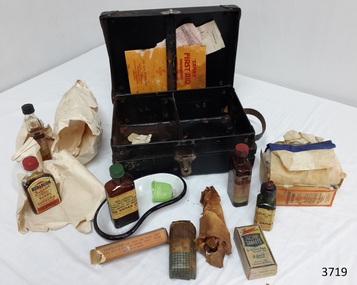
Equipment - First Aid Case, Thomas Urquhart & Son Pty Ltd (Thos. Urquhart), 1930-1939
... Victoria, which became a soldier settlement area after World War I... Victoria, which became a soldier settlement area after World War I ...This small, portable 1930s Sanax First Aid Case has been strongly constructed, with corners reinforced with metal to take knocks and bumps, so it could be quickly transported to the site of an emergency. Having these supplies organised into a kit made them easily accessible and reduces time to take them to the site of the accident. It was possibly designed for use in factories because the booklet in the case states that the kit complies with “Part 1, Victorian Factories Regulations”. The text of the printed brand “Sanax First Aid Case” is right-way up when the case stands vertically on its hinged side. In modern times people are well aware of the importance of quick treatment when accident and injury occur. However, before the first commercial First Aid Kit was made by Johnson & Johnson in 1888, people had little knowledge about treating injuries and lacked information about suitable supplies to keep on hand for emergencies. They were often unaware of how to help in that critical time before the doctor or other assistance arrived, a particularly important time for the many people living in remote areas. A quote from Johnson’s & Johnson’s 1888 price list explains “It is a fact, which is everywhere being recognized, that many lives are lost and much suffering entailed in such accidents on account of the lack of the simple but necessary articles required to afford prompt assistance to the wounded.” One example of the value of First Aid assistance to community groups is shown in an article from the Weekly Times, 29th November 1930. It records a report from the Annuello Branch of the Younger Set (a Country Women’s Organisation), telling that on Armistice Day their president Mrs Jamieson, presented the Annuello School with the gift of a Sanax Red Cross First Aid outfit, which was accepted as being “of great practical use to the scholars.” (Annuello is a remote wheat growing area in the Mallee region of North Western Victoria, which became a soldier settlement area after World War I. There is a strain of wheat named ‘Annuello’ due to its suitability for that area. ) The Sanax Case in our Collection contains instructions, equipment and medical items suitable for use in emergency situations. The Case was one of 42 patterns available from Sanax that conformed to ‘Part 1, Victorian Factories Regulations’. It includes items made by Sanax Company and by Burroughs Wellcome & Co. (Australia) Ltd., Sydney, NSW. A quote at the back of the First Aid Emergency Instructions booklet says: “Sanax products are made in Australia by or under the supervision of qualified chemists, from the highest quality materials. They are dependable for the purposes written on labels.” BOOKLET included in First Aid Case: “SANAX” First-Aid Emergency Instructions has orange cover and white pages, joined in the centre by two staples. Booklet contains First Aid Instructions for general events listed in alphabetical order. It also contains an indexed sections headed “Poisoning, and what to do” written by S.A. Burrows, Ph.C., Vuc and N.Z. There are instructions and diagrams on how to perform Artificial Respiration. There are advertisement for Sanax products throughout the booklet that include; - Sanax Ambulance Stretcher for timber mills, mines, ships and quarries - Saw dust masks (porous rubber) for workers in dust, paint or duco sprayers Inside cover lists Sanax’s Australian made products including - tablets and powders for headaches, neuralgia, influenza, colds - snuff for Catarrh that is “quite harmless” - First Aid Cases that come in a range of 42 patterns - sunburn preventatives and treatments - healing salve for carbuncles, pock, pimples, boils, varicose ulcers etc. - snake bite outfits and kits LEAFLETS included in First Aid Case: (1) Tannafax Tannic Acid Jelly. Tannafax should be kept at hand in every home. It should be applied direct from the tube and used with neither oil nor grease. Where a large area has to be covered the clamped end may be torn or cut off to give a wider mouth to the tube. Collapsible tubes of different sizes. Made in Australia. Burroughs Wellcome & Co. (Australia) Ltd. (Incorporated in England). Sydney, NSW. Assorted Houses, London, New York, Montreal, Cape Town, Milan, Bombay, Shanghai, Buenos Aires. Copyright A. 1817, J. 9463 (2) Tabloid. The strong thing is the just - - . Tabloid marks the wor - - Burroughs Wellcome & Comp. The use of the word is to enab – the prescriber, dispenser and patient to get the right thing with one short word, instead of the firm’s long name. If another maker apply the word to his product, the act is unlawful. Tabloid is our trade mark and brand. If a vendor disregard it in dispensing or selling, the act is unlawful for the same reason. We prosecute both offenders rigorously, in the interest of prescribers, dispensers, patients and the owners of the trade mark. Please inform us of any instance of either offence. Burroughs Wellcome & Co. (Australia) Ltd. (Incorporated in England). Telephone Number - M 4184 (4 lines) All communications to G.P.O. Box No. 1185 DD. Copyright Sy. 20. & J 9894. Medicines and Equipment included in First Aid Case: - Absorbent Cotton, Sanax, for absorbing blood or drying a wound. As a swab for washing wounds; to place above a compress to keep the heat in: or as a pad to protect wounds or fractures. The Sanax Co. Manuf. Chemists, Melbourne. Regd. Office: 5 Brunswick St, Fitzroy. N.6. - ACHE tablets, Sanax, for all aches, pains, fevers etc. Dose: 2 to 3 tablets with a draught of water, every 3 hours. Children in proportion. For influenza or colds, take the bedtime dose with a hot lemon drink or toddy. Recommended for Headaches, Colds, Influenza, Fevers, Neuralgia, Rheumatism, Nerve Pains, Sleeplessness, and Seasickness. Three Sanax Ache tablets equals one Sanax Ache powder. Each tablet contains 1.75grs. each Phenacotinum and Acety acSzilcyl, and .75grs Ammon Brom. Etc.. Sanax brand specialties are prepared by highly qualified pharmaceutical chemists and may be accepted as safe and effective for the purpose indicated on the label. The Sanax Co. Melbourne - Eye lotion, Sanax, “in eye bath full strength or diluted with equal parts of water. Sanax Co. Brunswich St, Fitzroy, Melbourne. - Iodine, Sanax, POISON, with instructions for what to do if swallowed. - Kuraburn, Sanax, Applied to the burn and allowed to dry, the pain and heat instantly disappear, and blistering is prevented. If necessary, apply again in an hours. To safeguard against burning when sunbathing, apply before exposure to the sun. If already sunburnet, use Kuraburn as directions above. Safe and harmless. Sole makers, The Sanax Co. Brunswick St. - - Vic. - Sal Volatile, Sanax, - - stimulant for - - nervous aches - - or as smelling salts Dose - - - - Solution of A- - - 5%, . The Sanax Co. Brunswick St, Melbourne. - Tannafax, Burroughs Wellcome & Co. Australia Ltd. Sydney, N.S.W., 20gm. Approx., Tannic Acid Jelly, (Tannic Acid with 0.5% Phenol in a water-soluble base) for burns and scalds. A.N. 15050, p188, logo of a unicorn. Apply lightly, allow to dry, and bandage loosely. Do not apply oil or grease. - bottle wrapped in brown paper, unknown contents, paper adhered to bottle. - dish, kidney shaped, metal, white enamel with black rim - eye bath, green, plastic or Bakelite SANAX COMPANY The Sanax Company was at the address of 5 Brunswick Street, Fitzroy [Melbourne] at least as early as November 1924, as shown by its advertisement of Ache Powder in the Weekly Times, 8th November 1924. It was still at this address in September 1951, when it advertised First Aid outfits and components in the Post Master General’s section of the Commonwealth of Australia Gazette. REFERENCES: Annuello, Victoria; Wikipedia, https://en.wikipedia.org/wiki/Annuello,_Victoria Annuello Younger Set, Branch Activities and Local Reports, Country Women’s Organisations, Weekly Times, 29 November 1930, Trove http://trove.nla.gov.au/newspaper/article/224921009?searchTerm=%22sanax%22%20and%20%22melbourne%22&searchLimits=# Commonwealth of Australia Gazette, Issue 32, 24th April 1915, https://www.legislation.gov.au/file/1915GN32 [Johnson & Johnson Price List, September 1, 1888, p. 20. From our archives], Celebrating the 125th Birthday of the First Aid Kit , The Story of Johnson & Johnson, , http://www.kilmerhouse.com/2013/06/from-1888-to-2013-celebrating-the-125th-birthday-of-the-first-aid-kit/ Post Master General’s section of the Commonwealth of Australia Gazette, Issue No. 73, Thursday 27th September 1951 http://trove.nla.gov.au/newspaper/article/232185299?searchTerm=%22sanax%22%20and%20%22fitzroy%22&searchLimits= Sanax First Aid Emergency Instructions, by S.A. Burrows, publisher Sanax Ltd. Fitzroy, Victoria, 1930-1939 English, book, Illustrated edition, Trove http://trove.nla.gov.au/version/40948895 Access to emergency medical help in early settlement days of Victoria could take quite some time, especially in remote areas. From 1888 First Aid Kits and instructions became available for work sites, offices, community groups and individuals, helping to bridge the gap between the accident and the arrival of medical assistance. This portable Sanax First Aid Case is an example of portable medical equipment made in Melbourne, Australia, in the 1930’s and available to the public. It contains a range of items plus information to be used in a variety of injuries and emergencies in in factories, households, businesses and local communities, and instructions on their use. First Aid Case, portable, Sanax First Aid Case. First Aid kit in strong black cardboard carry case with metal reinforced corners, metal hinges on lid, metal catch and leather carry handle. Inside lid is a vertical strap with narrow gap behind it. Base is divided into two compartments. Manufactured by Sanax, Fitzroy, Melbourne, C. 1930-1939 Contents include "Sanax" First Aid instructions booklet, 2 leaflets, metal kidney dish enamelled in white with black trim on edge, green plastic or Bakelite eye bath, eye lotion, Tannafax tannic acid jelly, Sal Volitile, Kuraburn, Iodine, Argyrol, ACHE tablets, absorbent cotton in cardboard box, gauze bandage, and UNKNOWN wrapped bottle. Printed in gold on lid of case “SANAX” FIRST AID CASE. Most of the contents, as well as the case, show the “SANAX” brand. Some contents are inscribed Burroughs Wellcome & Co. (Australia) Ltd., flagstaff hill, warrnambool, shipwrecked coast, flagstaff hill maritime museum, maritime museum, shipwreck coast, flagstaff hill maritime village, great ocean road, first aid items, first aid kit, emergency first aid, medical emergency kit, home emergency kit, industrial emergency kit, sanax company fitzroy melbourne, burroughs wellcome & co. (australia) ltd, thos. urquhart & son pty. ltd. melbourne, sanax first aid case, sanax first-aid emergency instructions, part 1 victorian factories regulations, tabloid medical supplies -
 Phillip Island and District Historical Society Inc.
Photograph Album, Kodak, Phillip Island Cemetery, c 1990
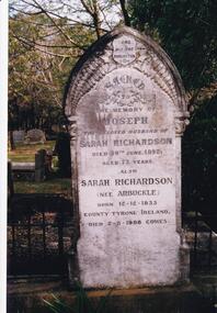
The Album was compiled by Nancy McHaffie late 1990's, with the assistance of Edith Jeffery's, with her book "Garden of Memories" and extensive knowledge of Phillip Island. The Cemetery lies back from the road and is surrounded by Manna Gums, rare Peppermint Gums, Blackwoods and other native trees. In all 25 acres of land were set aside as Crown Land in the land settlement of 1868. There are 6.2 acres of wetlands near the cemetery entrance.466-23: Joseph Richardson came to Australia in 1837 from Liverpool, England. Sarah Arbuckle and her two sisters arrived in 1850. Sarah and Joseph were married when gold was discovered in Victoria. They went to the diggings and had some success. Joseph bought land on Phillip Island when it was open to freehold selection in 1868. The family moved to Phillip Island shortly afterwards, to a house they built on a hill west of Cowes. They called their home "Everton" after a Liverpool suburb. The house still stands in Church Street, known as "Tallawalla". 466-24: The McIlwraith family came from Melton, Victoria to Heath Hill, Rhyll in 1869. They played an important part in the early history of Phillip Island. James was a foundation member of the Trust, John and Alan played their part in the local scene. John was President and Alan Secretary of the Cemetery Trust for many years.phillip island cemetery, nancy mchaffie, edith jeffery -
Phillip Island and District Historical Society Inc.
Book, HORTON, Thomas et al, Andersons of Western Port: the discovery and exploration of Western Port, Victoria, and the life of the first settler in Eastern Victoria, Samuel Anderson, and his two brothers, Hugh and Thomas. From 1797 to 1903, 1983
... -island-and-the-bass-coast anderson family crime settlement ...Signed by Thomas Horton.anderson family, crime, settlement, explorers, port victoria, western port, wonthaggi, pioneers, victoria, biography, history -
Phillip Island and District Historical Society Inc.
Book, MORGAN, Marjorie, Crown lands pre-emptive right applications : Victoria 1850-1854, 1987
... -island-and-the-bass-coast land settlement victoria history land ...Stamped 'Phillip Island & District Historical Society'. Facsim. reprint. First published as: Valuation of Crown Lands under Pre-emptive Right. Melbourne : 1855.land settlement, victoria, history, land subdivision -
Phillip Island and District Historical Society Inc.
Book, Korumburra &? District Historical Society, land of the lyre bird : a story of early settlement in the great forest of South Gippsland, being a description of the big scrub in its virgin state with its birds and animals, and of the adventures and hardships of its early explorers and prospectors, also accounts by the settlers of the clearing, settlement and development of the country, 1998
... -island-and-the-bass-coast land settlement victoria gippsland ...Stamped 'Phillip Island & District Historical Society'.land settlement, victoria, gippsland, south gippsland, personal observations, history -
Phillip Island and District Historical Society Inc.
Book, Historical Society of Victoria, Victorian Historical Magazine, Vol. XIX, June 1942, No. 3, 1942
... periodicals victoria Contains 'The early settlement of Phillip Island ...Contains 'The early settlement of Phillip Island' by A.D. Hardy. Stamped 'Phillip Island & District Historical Society'. Donor: Margaret Chisholm, 4.5.2005.royal historical society of victoria, periodicals, victoria -
Phillip Island and District Historical Society Inc.
Book, COLE, Valda, Western Port chronology 1798-1839 : exploration to settlement, 1984
Stamped 'Phillip Island & District Historical Society'.western port, history, victoria -
Phillip Island and District Historical Society Inc.
Book, COLE, Valda, Western Port chronology 1798-1839 : exploration to settlement, 1984
Signed by the author. Shelved in bookcases.western port, history, victoria -
 Greensborough Historical Society
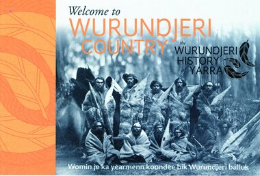
Booklet, Emily Fitzgerald et al, Welcome to Wurundjeri country: the Wurundjeri history of Yarra, 2014
Brief history of the Wurundjeri-willam people of the area now known as the City of Yarra, from pre-settlement times to the present.44p., paperback, printed in black and orange, illus.wurundjeri willam, city of yarra, aborigines - victoria -
 Phillip Island and District Historical Society Inc.
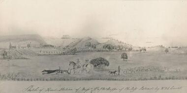
Photograph, Bryant West
One of a collection of over 400 photographs in an album commenced in 1960 and presented to the Phillip Island & Westernport Historical Society by the Shire of Phillip IslandPhotograph of a Sketch of Head Station of Messrs. W & W J McHaffie by W. & E. Liardet. Copy of water colour by Victoria's earliest artist late 1840's.Hand written inscription by W. J. McHaffie - "Sketch of Head Station of Mssrs. W & J.M. McHaffie of Phillip Island by W.F.E. Liardet."local history, photography, photographs, painting, early settlement, black & white photograph, farming, settlement, mchaffie, john jenner, bryant west -
 Greensborough Historical Society
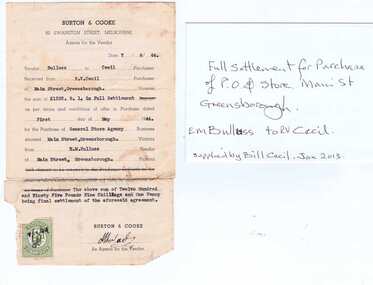
Receipt, Bill Cecil, Purchase of General Store and Post Office, 1944, 07/06/1944
Receipt for purchase of General Store and Post Office in Main Street Greensborough 1944. Purchaser: R.V. Cecil; Vendor E.M. Bulluss.The Cecil family were well known in Greensborough as operators of the General Store and Post Office at the time when Greensborough was a small country town.Original and copy of receipt. Printed on pale pink paper with Victoria Stamp Duty.Written on copy, next to receipt: "Full settlement for purchase of P.O. & store Main St Greensborough. E.M.Bulluss to R.V.Cecil. Supplied by Bill Cecil Jan 2013"e m bulluss, r v cecil, bill cecil, greensborough post office -
Glenelg Shire Council Cultural Collection
Book - Book Publication - 1984 150th Anniversary of Portland, 1984
... Anniversary of Portland as Victoria's first permanent settlement... Anniversary of Portland as Victoria's first permanent settlement ...A4 size publication 'Portland', made for 1984 150th Anniversary of Portland as Victoria's first permanent settlement. Covers cardboard, content, coloured photographs with black text. Front cover has photographs with black text. Front cover has photographs of Kingsley, historic painting, harbour at sunset, lifesavers, oil rig and yachts Henty Beach; with red border. Back Cover: Glenelg river -
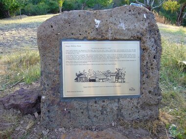 Greensborough Historical Society
Photograph - Digital Image, Happy Hollow plaque, 05/02/1840o
The land surrounding Happy Hollow farm at Plenty was purchased by Francis Wickham in 1840. The land was later subdivided and held by various owners including Charles Partington (1875) and John McLaughlin who leased the property in 1892 to Robert Emmett Whatmough who erected the first dwelling on the property. The land was later owned by Mrs Betty Bell and was purchased by Parks Victoria in 1994 to form part of the Plenty Gorge Parklands. This plaque was laid by Plenty Historical Society.Happy Hollow was an example of early settlement along the Plenty River.Digital copy of colour photograph. Plaque at Plenty Gorge Parklands.plenty river, happy hollow, happy hollow farm, robert emmett whatmough, betty bell, john mclaughlin, charles partington, parks victoria -
 Greensborough Historical Society
Newspaper, The Melbourne Sun, The Sun. November 1984: Victoria's 150th Anniversary Souvenir, 1984_11
... This issue of The Sun New-Pictorial celebrates Victoria's... celebrates Victoria's 150th anniversary of white settlement ...This issue of The Sun New-Pictorial celebrates Victoria's 150th anniversary of white settlement and includes the Program of celebrations through out the State. Also includes articles on various aspects of life in Victoria.56 pages, black and white and colour images and black text.victoria 150th anniversary, victoria