Showing 21014 items matching shire%20of%20blackburn%20and%20mitcham
-
 Greensborough Historical Society
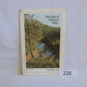
Book, Shire of Diamond Valley, The Shire of Diamond Valley Handbook 1977, 1977_
The Shire of Diamond Valley was a Local Government Area located about 20 kilometres northeast of Melbourne. The shire covered an area of 74.38 square kilometres and existed from 1964 until 1994.Annual guide to services in Shire of Diamond Valley18pages, illus (some colour), maps. Front cover photograph "Plenty Gorge".shire of diamond valley, greensborough, handbooks -
 Greensborough Historical Society
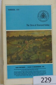
Book, The Shire of Diamond Valley Handbook 1979, 1979_
The Shire of Diamond Valley was a Local Government Area located about 20 kilometres northeast of Melbourne. The shire covered an area of 74.38 square kilometres and existed from 1964 until 1994.Annual guide to services in Shire of Diamond Valley32 pages, illus (some col.), maps. Cover illustration is a copy of the Ellis painting "Village of Greensborough 1889".shire of diamond valley, greensborough, handbooks -
 Greensborough Historical Society
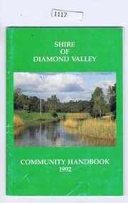
Book, Shire of Diamond Valley, The Shire of Diamond Valley Handbook 1992, 1992_
The Shire of Diamond Valley was a Local Government Area located about 20 kilometres northeast of Melbourne. The shire covered an area of 74.38 square kilometres and existed from 1964 until 1994.Annual guide to services in Shire of Diamond Valley54 pages, illus (some colour), maps. Front cover photograph:Kalparrin Gardens Greensboroughshire of diamond valley, greensborough, handbooks -
 Eltham District Historical Society Inc
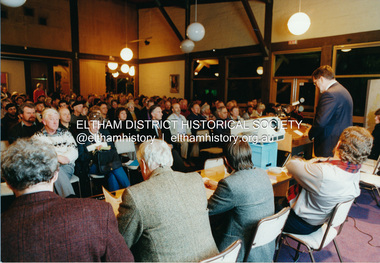
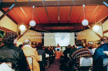
Photograph, Shire of Eltham, Meeting to discuss the new Nillumbik Shire, November 1994
Nillumbik Shire Council - Shire of Eltham Archives Series 046 Series consists of colour photographs, 215mm x 150mm, depicting citizens and speakers at the meeting, including CEO Rodney Roscholler.Colour photograph1994, council amalgamation, nillumbik shire, public meeting, shire of eltham, series 46, shire of eltham archives -
 Eltham District Historical Society Inc
Photograph, Shire of Eltham, Meeting to discuss the new Nillumbik Shire, November 1994
Nillumbik Shire Council - Shire of Eltham Archives Series 046 Series consists of colour photographs, 215mm x 150mm, depicting citizens and speakers at the meeting, including CEO Rodney Roscholler.Colour photograph1994, council amalgamation, nillumbik shire, public meeting, shire of eltham, series 46, shire of eltham archives -
 Stawell Historical Society Inc
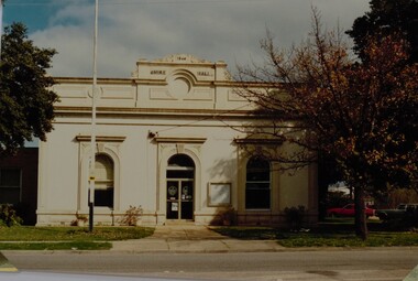
Photograph, Stawell Shire Hall 1866 c1988 -- Coloured
Photograph of Stawell Shire Hall taken 1988. 1988 view of the Stawell Shire Hall. Photo taken from the other side of the road. The decoration on top of the building is missing. The tree on the right hand side is losing its leaves and 2 cars are parked on the right, behind the tree. Stawell Shire Hall 1988 Geoff Oates P.O. Box 402 Stawell.stawell -
 Eltham District Historical Society Inc
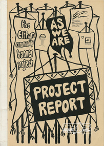
Book, Jacky Talbot, The banner habits of the Eltham tribes : Eltham Shire "as we are" Community Banner Project report / by Jacky Talbot, 1987
Also titled: Eltham Shire "As We Are"The 'As We Are' Community Banner Project was the first major Community Arts project initiated and co-ordinated through the resources of the Shire of Eltham. It was originally conceived and inspired by a local textile artist, Tracey Naughton, who, together with the Community Services Manager of this local government council, made the idea a very concrete and flourishing reality. As the following report reveals, the project grew from the original fourteen or so intending participant groups to fifty-seven banners; expressions of those diverse groups' interests and identities. As a first major project it was rightly felt by Tracey Naughton, who became the Shire's first Community Arts Officer in March 1985, that it should be fully documented, so that an appraisal of the extensive growth of this community arts development process could be assessed. Given the time and money available to do this the writer, Jacky Talbot, and her advisors, decided it was appropriate to select fifteen or twenty banners for detailed analysis. This was done by taping interviews with members of the chosen groups. The groups were chosen to cover all ages participating, from the toddlers in the Playhouse to our grand elder citizens in their Nursing Horne, and to cover a wide range of different types of groups - schools, scouts, churches, youth issue based, and the numerous women's groups of various combinations, localities and concerns. ·. Some groups who presented their banners for the culminating highlight of this project - the Exhibition, held at the Eltham Community Centre on October 9th, 1986, had no contact with the Shire or project co-ordinator, but heard about the project through the local news' networks or other participants. The extent of community participation was enormous. It involved hundreds and hundreds of people. It changed some people's lives, enlivened others. As a first step on a new road its success is notable. The 'As We Are' Community Banner Project took place in the Shire of Eltham and neighbouring environs for approximately 12 months, from October 1985. Paperback; 68, [10] leaves : ill. ; 30 cm. Two copiesflags, emblems, banners, eltham, shire of eltham, community -
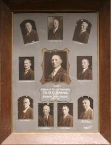
 Pyrenees Shire Council
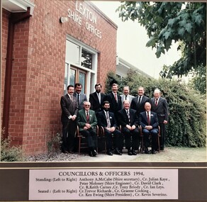
Photograph, Shire of Lexton Councillors and Officers
significant to the Pyrenees Shire and Lexton communityframed photograph of Shire of Lexton Councillors and Officers "Inscribed front: Shire of Lexton Councillors & Officers 1994" -
 Heidelberg Golf Club
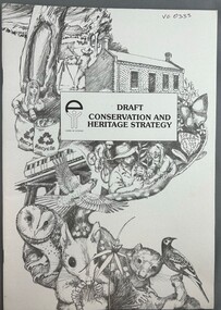
Book, Shire of Eltham, Draft conservation and heritage strategy of the Shire of Eltham, 1990c
Draft conservation and heritage strategy of the Shire of Eltham.43 p., illus.Draft policy for discussioneltham, shire of eltham, conservation -
 Colac RSL Sub Branch
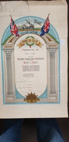
Work on paper - Certificate, Shire of Colac, Shire Of Colac. Presented to Private E. Obourne, 09/09/1946
Certificate awarded by Shire of ColacPaper Certificate non-fictionCertificate awarded by Shire of Colaccertificate of appreciation, 2nd world war, colac -
 Greensborough Historical Society
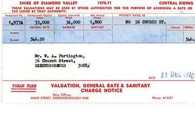
Financial record - Account, Shire of Diamond Valley, Shire of Diamond Valley rates notices 1970-1971, 26/03/1958
Shire of Diamond Valley Rates assessment issued to Alan Partington in 1970. This land is assessed as an "Urban Farm". In 1974 the 'farm rate' was declined for this property, eventually leading to its acquisition by the Shire for recreational space, now known as Whatmough Park.Part of the property owned by the Partington family in the original Greensborough farmland. Rates notice, printed in red text with black typed details.Date stamped with rubber stampalan partington, william alan partington, partington family, land deals greensborough, church street greensborough, whatmough park -
 Greensborough Historical Society
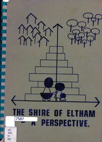
Book, Lodi Francesconi, The Shire of Eltham - a perspective, 1981_07
Collection of statistics and projections relating to the Shire of Eltham as at 1981123 p. typescriptnon-fictionshire of eltham, statistics, eltham -
 Greensborough Historical Society
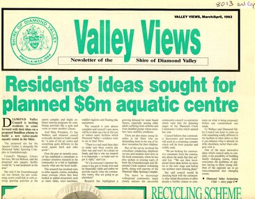
Newspaper - Newsletter, Shire of Diamond Valley, Valley Views: Newsletter of the Shire of Diamond Valley. March/April 1993, 1993_03
Local news from the Shire of Diamond Valley 1993. Includes plans for a swimming pool for the Civic area; extension to the Diamond Valley Library; extended hours for Maternal and Child Health centres; entertainment in the Shire; radio station Plenty Valley fm; and, treatment for headlice.Newspaper, 8p., green and black text, black and white images. 2 copiesshire of diamond valley, swimming pools greensborough, diamond valley library, plenty valley fm -
 Greensborough Historical Society
Form, Shire of Diamond Valley, Shire of Diamond Valley: Inter-office memo, 1990_
Inter-office memo pad from Shire of Diamond Valley.Inter-office memo: 2 copies on padshire of diamond valley -
 Eltham District Historical Society Inc
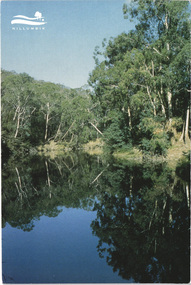
Postcard - Photograph, Shire of Nillumbik, Yarra River, southern boundary of the Shire of Nillumbik, c.2010
Nillumbik Shire Council c.2010 Arts Environment Heritagepostcard, birrarung, shire of nillumbik, yarra river -
 Marysville & District Historical Society
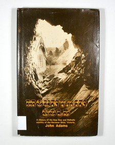
Book - Hardback book, Mountain Gold-A History of the Baw Baw and Walhalla country of the Narracan Shire, Victoria, 1980
A history of the Baw Baw and Walhalla country of the Narracan Shire, VictoriaHardback. Brown dust cover. Photograph on front cover looks out from the entry of a mine onto the front of a building which has a hill to the side of it. The back cover has a photograph of the side of a hill with some trees on it.G&V THOMAS Stamp of the Marysville & District Historical Society Inc / P.O. Box 22 / Marysville 3779gold, gold field, gold miner, gold mining, gold town, walhalla, baw baw, gippsland, victoria, australia, history -
 Federation University Historical Collection
Booklet - Book, John Fraser & Son, Buninyong Shire Centenary, 1958
Record of special meeting of the Council of the Shire of Buninyong on 28 August 1958 to commemorate the hundredth anniversary of the Council. Record includes photographic copies of the Victoria Government Gazette marking the establishment of the Buninyong Road District, details of the inaugural council meeting, a message from the first Chairman, a list of council members 1958, a list of council chairmen, presidents and secretaries, extracts from past council records and images of the Buninyong district and first Chairman Archibald Fisken and President 1957-58 Archibald Clyde Wanliss Fisken..1) Beige soft covered book 14 pages with images of four generations ofArchibald Fisken, KW McManus and other details related to the 100 years of the Buninyong Shire Council .2) Luncheon menu to mark the centenary of local government in the district of BuninyongShire of Buninyong 1858-1958buninyong shire council, buninyong road district, archibald fisken, buninyong -
 Sunshine and District Historical Society Incorporated
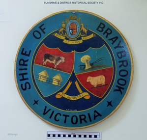
Plaque, A. H. Walker, COAT OF ARMS - Shire of Braybrook Victoria, Unknown date of manufacture
From around circa 1850 Braybrook was already well established and became a staging point for prospectors on their way to the diggings. Local government for this rural area to the west of Melbourne came when the BRAYBROOK ROAD DISTRICT was proclaimed on 28 May 1860. This authority was superseded on 23 January 1871 with the formation of the SHIRE OF BRAYBROOK. The Shire of Braybrook existed for about 80 years during which time it experienced significant industrial growth. The Shire of Braybrook ceased to exist in 1951 when the CITY OF SUNSHINE was formed.The Coat of Arms informs the observer that the Shire of Braybrook was initially a rural area with its images of a cow, sheep, and hay. The reference to industry however probably does not indicate adequately the large growth in industrial activity that occurred within the Shire. Circular board of Masonite painted by A. H. Walker which is a true depiction of the Coat of Arms for the Shire of Braybrook. It is mainly blue, yellow and red coloured with black writing, and has images of a cow, sheep, and hay, and also indicates a reference to industry.Shire of Braybrook Victoria / Dieu Et Mon Droit / By Industry / A. H. Walkercoat of arms, shire of braybrook, a. h. walker, plaque, sunshine -
 Eltham District Historical Society Inc
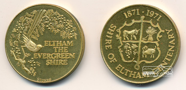
Medallion, Shire of Eltham, Medallion, Shire of Eltham Centenary 1871-1971, 1971
The medallion was issued to all ratepayers in celebration of the Shire of Eltham's Centenary in 1971Gold coloured medallion approx 2.5 cm diameter in a clear plastic sleeveshire of eltham, shire of eltham centenary, medallion -
 Learmonth and District Historical Society Inc.
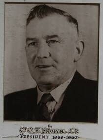
Photo - Brown, Untitled, Shire President Charles Edward.(Ted)Brown,(J.P.),and Councilors 1959, 1959 (exact)
Councilor C.E.Brown was elected to council in 1946 and served til 1973.He was Shire President in 1952-53,1955-56,1959-60,1963-64,1971-72. This photo forms part of a collection of photos of all Councilors for the year 1959-60.Orininal Historical Photo of all Councilors for the Financial year 1959.Sepia photo, on white mount, of Shire President C.E.Brown,(J.P.).Situated middle of second row of composite collection of photos of councilors in the year 1959.Shire President C.E.Brown and councilors, to commemorate the opening of the Wendouree Municiple Centre 20th November 1959.president, 1959 60, brown, c e, 1959, wendouree municiple centre opening 1959, ballarat shire council -
 Learmonth and District Historical Society Inc.
Photo - Spittle.S.G.& Councilors, Richards & Co. Photos Ballaarat, President S.G.Spittle & Ballarat Shire Councilors 1934 - 1935, 1935 (exact)
This Collection of photos was taken during Victoria' centenary year,and depicts Shire President Samuel Gordon Spittle,and Councilors C.T.Henderson, M,J,Ryan, D.Baird, J.A.Charles(J.P.), W.A.Rain (Secretary & Engineer), R,T.White, R.B.Walton, H.J.Wheeler, and W.R.Crosthwaite. Original Historic Photo Of Councilors for the 1934 - 1935 year.This is a composite collection of photos,Sepia in colour,on grey mount,with gold surounding middle photo,and framed in wide plain wooden frame.It is of Shire President Cr Samuel Gordon Spittle and Councilors For the year 1934 - 1935. PRESENTED BY THE PRESIDENT CR.S.G.SPITTLE TO THE BALLARAT SHIRE COUNCIL.1934-35.shire president samuel gordon spittle, ballarat shire council 1934 1935, victoria centenary year 1934 1935 -
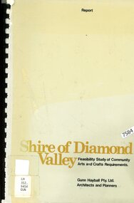 Greensborough Historical Society
Book - Feasibility Study, Gunn Hayball Pty Ltd, Shire of Diamond Valley: Feasibility study of community arts and crafts requirements, 1977, 1977_
An investigation into the need for, and availability of art and craft activities in the Shire of Diamond Valley in 1977.68 pages text and black and white line drawings and tables. Black plastic binding. non-fictionshire of diamond valley, leisure activities, art and craft -
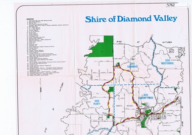 Greensborough Historical Society
Map, Map - Shire of Diamond Valley, 1990c
Map issued by the Shire of Diamond Valley showing location of key organisations and features Map printed in colour, one sideshire of diamond valley -
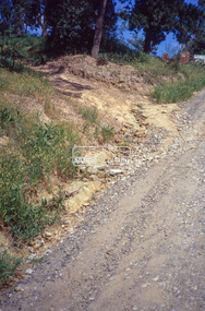
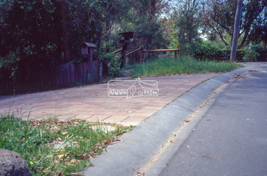 Eltham District Historical Society Inc
Slide - Photograph, Eltham Shire Council, Roadside drainage control, unidentified road, Shire of Eltham, c.1989
Eltham Shire Council review of various kerb profiles and road side drainage35mm colour positive transparency Mount - Black and Whiteinfrastructure, footpaths and gutters, road drainage, roads, shire or eltham, streets -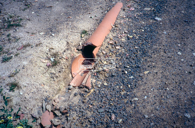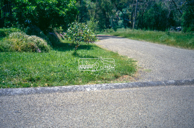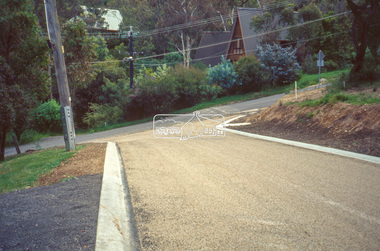
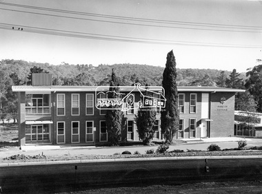 Eltham District Historical Society Inc
Photograph, Eltham Shire Office, shortly after duplication of Main Road, c.1968
Eltham Shire Council office built 1964 on the former site of Shillinglaw Cottage. In 1971 the offices were extended with a southern wing (to the left of the building) which housed the Eltham Library and planning offices. Taken shortly after widening of Main Road between Pitt Street and Elsa Court which was undertaken between February 1968 and August 1968. Image was most probably commissioned by Eltham Shire Council and taken by Hugh Fisher, photographer who operated from premises between Arthur and Dudely streets and was often contracted by the shire for official photographic work. The image was used in the August 1971 issue of Australian Municipal Journal This photo forms part of a collection of photographs gathered by the Shire of Eltham for their centenary project book,"Pioneers and Painters: 100 years of the Shire of Eltham" by Alan Marshall (1971). The collection of over 500 images is held in partnership between Eltham District Historical Society and Yarra Plenty Regional Library (Eltham Library) and is now formally known as the 'Shire of Eltham Pioneers Photograph Collection'. It is significant in being the first community sourced collection representing the places and people of the Shire's first one hundred years.Digital image and 120 format B&W negativesepp, shire of eltham pioneers photograph collection, eltham, main road, duplication, road widening, shillinglaw trees, local government -
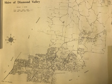 Greensborough Historical Society
Map, Shire of Diamond Valley, 1964-1994
Map of the former Shire of Diamond Valley, 1964-1994, showing the local government area from Greensborough to Hurstbridge.Map on yellowed paper.shire of diamond valley, greensborough, hurstbridge