Showing 141 items matching "south boundary road"
-
 Warrnambool and District Historical Society Inc.
Booklet, Allansford Progress Association, Second half of 20th century
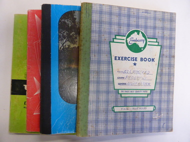
These four exercise books give documentation on the activities of the Allansford Progress Association (1966 to 1988). Allansford is a settlement about 9 kilometres from Warrnambool and most of the town area is now within the boundaries of the Warrnambool City Council. The association was re-formed in November 1966 after the demise of an earlier group. The members of the group campaigned in areas of local concern – T. V. reception, drainage and sewerage, postal services, sports facilities including the development of the Speedway, housing development, road proposals, waste management and disaster plans. These books are of interest in that they provide an overview of the history of a local organization. They will be useful for research. These are four exercise books - three Minutes books, and one Accounts book, from the Allansford Progress Association (1966-1988). The exercise books have coloured covers, (blue and white checkered, green, red and blue). Two are bound with tape and two are stapled. There are some loose sheets in all of the books. All the entries are handwritten. On front covers: ‘Allansford Progress Association’allansford progress association, history of allansford, history of warrnambool -
 Warrnambool and District Historical Society Inc.
Book, The Autography of a Merchant, late 19th century
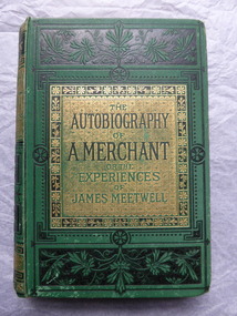
This book was given in 1886 as a prize to Annie Egerton from Allansford State School. The prize was for recitation. Allansford State School No. 3 was opened in 1856 as a National School and is still operating. Allansford is about ten kilometres from the Warrnambool city area and most of it today is within the boundaries of the City of Warrnambool. John Jones was the Head Master of the school from 1867 to 1891. No details have been found on Annie Egerton or her family This book is of interest because it concerns 19th century Allansford State School, Head Master John Jones and pupil Annie Egerton. It is also a book of antiquarian interest. This is a hard cover book of 436 pages. It has a green cover with gold and black ornamentation and black and green lettering. The pages are edged with gold colouring. The book has 36 chapters telling the story of the merchant, James Meetwell and some pages at the back giving details of other books available from the publishers, Ward, Lock & Co. The cover is somewhat soiled. There is an inscription inside the front cover with handwriting in black ink and the word ‘Reciting’ written in pencil on the second page. ‘Allansford S. School, 3, Presented to A. Egerton for Reciting, 19-4-86, J.E.Jones, teacher’ ‘Reciting’ annie egerton, allansford primary school, john jones,, allansford state school, history of allansford -
 Ringwood and District Historical Society
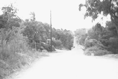
Photograph, Glenvale Road, North Ringwood - a boundary looking south. 1979
... - a boundary looking south from top of same hill (near Kubla Rd?).More..., "Jan. 79. Glenvale Road - a boundary looking south from top ...[Kubis Dve or Kubba Rd?.]Written on back of photograph, "Jan. 79. Glenvale Road - a boundary looking south from top of same hill (near Kubla Rd?).More homes south than north." -
 Ringwood and District Historical Society
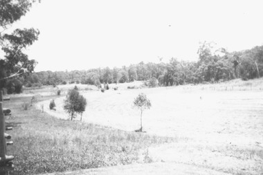
Photograph, Boundary Photo across Dandenong Ck towards Ringwood (H E Parker Reserve). 1979
Written on back of photograph, "Jan. 79 - boundary photo. Looking across Dandenong Creek towards Ringwood (H.E. Parker Reserve) - ?? South East corner of Ringwood. From children's playground end of Derwent (?) St." -
 Ringwood and District Historical Society
Pamphlet, G.A. Green, Auction Sale Brochure - Garden Farms Estate, Ringwood, Victoria - 1919, 1919
Multi-fold brochure advertising public auction of one-acre, 2-acre, 5-acre and 8-acre allotments in Ringwood and Bayswater on Saturday 12th April, 1919. Brochure includes terms of sale, description of subdivision features and local facilities, and photographic images of the area.Subdivison includes Canterbury Road Heathmont, Armstrong Road Heathmont, Armstrong Road Bayswater, Bungalook Road Heathmont, Bungalook Road Bayswater, and Orchard Road Bayswater. Road shown as Bayswater Road to Bayswater became Mountain Highway Bayswater. Vendor: H.E.B.Armstrong, Auctioneers: Coghill & Haughton, 79 Swanston Street Melbourne, Telephone Central 2793, in conjunction with J.B. McAlpin, Ringwood, Opposite Station, Telephone Ringwood 7. (Map) Woodcock & McCormack, Civil Engineers Architects & Surveyors, 430 Little Collins Street, Melbourne, Phone 3241 Central. MOST OF THE MONEY COMES OUT OF THE LAND. And more money can be obtained from anb acre of fruit than from an acre of any other produce. But you do not have to grow fruit on Garden Farms Estate. You can go in for - Outer Suburban Home - Market Garden - Orchard - Pig Raising - Poultry Farm - Small Dairy Farm - Small Fruits - Floral Culture - Scent and Bee Farm - Or just for a Week-end Home. RINGWOOD - THE PLACE TO LIVE. The Beautiful Ringwood District has so many natural attractions, that half a Land Agent's work is done in just showing a prospective buyer round and about. Ringwood has a pull of its own that attracts folk, proved beyond doubt by its rapid development within the last decade (spite the war). First, it is high and healthy, picturesque and undulating, convenient of access, sufficiently close to the Metropolis for City and Business folk to live at Ringwood. Its development is solid, because most of its people are industrious husbandmen, real producers, who have turned idle hills into smiling gardens. These are the kind of real people to live amongst; ones who wear out their spades. The rapidly-developing town has excellent Stores, Trade and Repair Shops Churches, Banks, Telephone Exchange, Weekly General Market, Cool Stores, and good Private and State Schools, etc.; is Electrically lit, has Metropolitan Water Supply, and generally provides so that practically all shopping can be done locally. WHY RINGWOOD MUST GROW. Ringwood is a great centre and must be a greater. Two rapidly-developing railways junction here. The passengers from Ringwood Station cityward, in one year, number 250,000. Ringwood will be the terminus of the Outer Suburban Electric Eastern Railway. Its natural boundaries are the River Yarra on the North, Dandenong Creek on the South, the popular town of Croydon on the East, and the suburb of Mitcham on the West. This is a large territory that is steadily being converted from intense culture, and then it might be called (as regards its gardens) "The Devon Territory of Victoria." ARMSTRONG ROAD. This new road traverses Garden Farms Estate from its northern boundary on the main Canterbury Road, across Dandenong Creek, to its southern boundary on the main Bayswater Road, and will provide a long-desired additional link of communication between Bayswater and Ringwood. The 1-acre building sites on Bayswater Road are within 8 minutes' walk of the Bayswater Railway Station, and the Canterbury Road frontages are only 1-1/2 miles from Ringwood Station, and 1/2 mile from the Railway Station site of Canterbury Road; therefore, the whole Estate is easy of access and there should be a large demand for land so favourably placed. (Image) Cultivation Field - Potatoes on Lot 28 (Image) Picture of Bayswater Creek Flats. (Image) View from "Korumbeen" where Mr. Armstrong lived on Garden Farms Estate. Estate outlined in white ring. (Image) Site of New Bridge over Dandenong Creek. (Image) On one of the timbered lots adjoining railway. (Image) This Dandenong Creek traveres the Estate. (Image) Main Fern Tree Gully Line bisects the Estate. -
 Glen Eira Historical Society
Document - St. Christopher’s Anglican Church, Bentleigh East
4 items: 1/Three parish newsletters dated May 1957 and December 1959, and Christmas 1959, and undated. Newsletter about fundraising for new church building completed in 1969. 2/Three Christmas church service details for 1979, 1984, one undated and one for 09/05/2010. 3/Photocopy of booklet dated 1977 celebrating 25 years of the church and list of invitees and 2002 celebration of fifty years of the church and order of service dated 08/09/2002, and photocopy of recollections, handwritten, by Mrs. Iris Fowler in 2002 of her years as a parishioner. 4/Two pages of names of St. Christopher’s Pioneers, handwritten, dated 24/07/2012 by Clare Barton. Newsletters all contain lists of officials and various parishioners, and advertisements by local businesses, and lists of all ministers and curates.st. christopher’s church of england, centre road, mackie road, bentleigh east, chambers david h. rev., green laurie v. rev., st. john’s church of england, glasscock geoffrey t. rev., brady road church of christ, brooker burne, east boundary road, north road, bignell road, south oakleigh uniting church, st. peter’s catholic church, east boundary road uniting church, kenny charles rev., cecil street, cottier john rev., poole tony, churches, anglican church, church services, church festivals, christmas, sunday schools -
 Federation University Historical Collection
Book, Mount Helen campus Development Plan 1970, 1970
Green and white soft covered booklet of 48 pages. SMB Crest is on the front cover. The content include the Mt Helen site, site planning, student residences, sporting facilities, roads and parking, pedestrian circulation, engineering services, and landscaping. Illustrations include: Plan of Mt Helen Site (July 1969, existing buildings, Functional relationship, Roads and Parking, Pedestrian Circulation, engineering Services, Landscaping, Development Plan, Plan of Academic area, Library and union Courtyards, Birds Eye View of Academic Area from north-west, etc. the master plan projects student numbers.non-fictionuniversity of ballarat, ballarat institute of advanced education, mount helen, master plan, landscape, harrison, vernon, great hall, geoff harrison, john vernon, m.b. john, contour map, student accomodation, landscaping, development plan, campus plan -
 Federation University Historical Collection
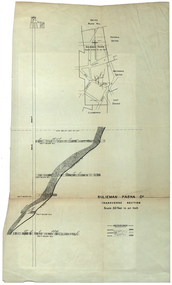
Plan, Sulieman Pasha Co Plan Transverse Section
The Sulieman Pasha is possibly named after the most important Sultan of the Ottoman Empire, Suleiman One, or Suleiman the Magnificent, when the Ottoman Empire was at its peak. Or potentially a number of Ottoman governors, statesmen and military commanders with the same name after, however the spelling is slightly different to the mine name. No Turkish connection was found relating to the formation of the company, and remains unconfirmed. The mine operated from two shafts; No. 1 near the corner of Humffray and Mair streets, and also near where the Welcome Nugget (2217 ounces) was found years earlier; and the controversial No. 2 shaft several blocks south bordering the northern side of the main highway through Ballarat. The company produced 62 666 ounces of gold, the twelfth highest quartz reef gold production for any mine on the Ballarat goldfield. Some crushing figure examples are January-June 1881: 3674 tonnes 1085 ounces; January-June 1885: 2949 tonnes 1281 ounces; July-December 1885: 4459 tonnes 1119 ounces; January-June 1887: 1869 tonnes 730 ounces; July-December 1892: 1450 tonnes 771 ounces; July-December 1896: 4365 tonnes 1372 ounces. Like many mines in the area, gold grades were low. John Watson was noted as mine manager in the 1880s, and John Williams 1890s. The company was re-organised twice increasing the number of shares from 4000 to 24 000, and increasing the capital available. The Sulieman Pasha Company was formed in 1878. David Fitzpatrick was given the honour of turning the first sod of both the No.1 and later No. 2 shafts. The first dividend was given to shareholders in July 1881. The company obtained a prospecting vote (government grant) to start, and was very proud to be the first Victorian gold mining company to pay the funds back to the government. The event was marked by a lavish banquet laid out for ministers and government officials by the company. Leases were purchased to the south in 1885 to the Llanberris Mine boundary, after poor results began accumulating from the small No. 1 shaft. To take advantage of this new land the company planned to sink a second shaft. Initially this was to take place on government land, but the uproar from nearby residents caused the company to purchase land along the Main Road (now Western Highway), and the old Yarrowee Hotel which had occupied the site since the alluvial digger days of the 1850's was demolished. The area had since those days become heavily occupied with a number of shops, houses, a post office, church and two schools in the immediate area. The thought of an underground mine next door drew considerable opposition. The company (before the days of public relations departments) wrote 'most people would have thought that progress as vital as mining would be supported by tradesmen whose business rely on the mining industry. It seems when it comes to mining they are bereft of their senses, and considering the low ebb of mining in Ballarat East, the action of our opponents are unaccountable. (Sarcastically) There are certain engineering difficulties in moving the quartz reefs to a new location, but if we could to appease our opponents we would'. The company also wanted to take over 4 acres of the St Paul's school oval for machinery, but accused the St Paul's Church of wanting extortionate amounts of money upfront, and on a yearly basis for the privilege. It stated the church could not be opposed to mining when several years earlier it had formed its own company to mine the land, only for shareholders to lose their money. In 1886, the company approached the Minister for Mines, and attended heated public meetings on the matter. The local residents, shop owners, and church submitted a 60 person petition to the local council and government authorities. They stated the shaft contravened the mining statutes, which stating no mining could take place within 150 yards of a public building or church. A speech by a resident stated 'mining always comes with glorious pictures of the great benefits which would accrue all parties concerned if their request is granted, but if property is destroyed or depreciated in value, no-one then comes forward and compensates them'. The No. 2 shaft was approved including taking over part of the school oval. In 1888, workers at the company's No. 2 shaft went on strike to try and bring their wages in line with other mines in the district (the No. 1 shaft was operated by tributers). William Madden (26) was killed from a fall of earth underground the same year, while a year later his father John Madden (70) was similarly killed in the Madame Berry Mine elsewhere in the district. In 1897 as the amount of gold being found fell away, it came to light part of the deal to purchase the Yarrowee Hotel site was a 5% royalty on gold found. Shareholders could not understand why they were paying a royalty to the former owners of the property. The mine closed in 1898 due to a lack of gold. In 1902 a boy (age unknown) called Charles Lee was killed from a fractured skull while working to dismantle the Sulieman Pasha plant. The fuss over the No. 2 shaft had a sequel. On the company winding up, the land was purchased by J.S. Trethowan who built a house next to the shaft. In 1907, the shaft caved-in creating a sinkhole immediately at the back of the house. A Mr Chamberlain heard a deep rumbling sound at 5am, and looked out the window to see his fowl house and thirteen chickens disappear down an expanding hole. He then went back to bed, and called the police later in the day. The shaft was 1050 feet deep, and the hole at the surface that developed was 20 feet by 17 feet across, and 20 feet depth. In 1930 it is reported a syndicate had been formed to clean out the old shaft, and re-open the mine. It is assumed this was the No. 1 shaft but no more was found. (https://www.mindat.org/loc-304239.html, accessed 07/08/2019) A transverse section plan of the Sulieman Pasha Mine.sulieman pasha company, plan, mining, united black hill mine, victoria united mine, victoria street, britannia united mine, last chance mine, llanberris mine, ottoman empire, john watson, john williams, david fitzpatrick -
 Ringwood and District Historical Society
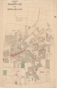
Map, Borough of Ringwood, Victoria - c.1950s
A0-size (approx) map of named streets and lot-numbered properties within Borough of Ringwood ward boundaries. Colour-coded key marking Land Under Control of Council, Factory Areas, and Business Areas.Scale: 8 chains to 1 inch. North Ward, East Ward, South Ward. -
 City of Moorabbin Historical Society (Operating the Box Cottage Museum)
Photographs,x3 Colour Early Weatherboard Cottage Cheltenham c1880, 1981
... ' that extended from Brighton bayside North Road, East Boundary Rd... Brighton bayside North Road, East Boundary Rd to South Road ...Henry Dendy , a farmer from Sussex England, purchased 5,120 acres of land in the area of a 'Special Survey 1841' that extended from Brighton bayside North Road, East Boundary Rd to South Road. This area became known as Dendy's Brighton and as part of the sale 139 emigrant workers arrived in 1842 however Dendy was unable to find work and lodgings for these people. J.B.Were, financier took over the management of the 'Special Survey 1841' area and began to sell and lease allotments. 1850 the Squatter King brothers sold land south of Dendy's 'Special Survey 1841' to Josiah Holloway who sectioned it into 2 acre lots @ £10 each for market gardens - 'Two Acre Village' and Charles Whorral opened a small hotel - 'The Cheltenham Inn' on the main Road - Arthur's Seat Rd, later Point Nepean Rd, now Nepean Highway. Notable settlers who moved into the area were Keys, Charman, Bruton, Le Page, Fairlam, Meeres and 1862 saw the separation from Brighton and the formation of the Mooorabbin Roads Board District. .By 1879 1000settlers were living in 'Cheltenham' serviced by a Post Office with Bank, Mechanics Institute, State School No 84,Keys Hotel, Meeres Store, Sir Thomas Bent ensured the new Railway Line from Caulfield to Mordialloc went through his constituency of Cheltenham 1881 and this changed the development to the bayside area of Cheltenham away from the 'Two Acre Village ' side causing some dissention, However Cheltenham as whole prospered and this house in Pine St is typical of the cottages built c 1890- 1900 in the area. This weatherboard house c 1890-1900 in Pine St Cheltenham is typical of those built for early settler families. Photo taken 1981 by CMHS member 3 x Colour photographs of an early c 1900 weatherboard house in Pine St Cheltenham taken by CMHS member 1981Kodak Aug. 81 / Handwritten Pine St Cheltenhamkeys robert, holloway josiah, king brothers, smith j l; smith mary ann, stanley helen, chaff cutter, horse drawn carts, toll gates brighton, motor cars 1900, steam engines, early settlers, bentleigh, parish of moorabbin, city of moorabbin, county of bourke, moorabbin roads board, shire of moorabbin, henry dendy's special survey 1841, were j.b.; bent thomas, o'shannassy john, king richard, charman stephen, highett william, ormond francis, maynard dennis, market gardeners, vineyards, orchards -
 City of Moorabbin Historical Society (Operating the Box Cottage Museum)
Newsletter, City of Moorabbin Historical Society Feb 2009, February 2009
The City of Moorabbin Historical Society was formed c 1960 by a group of Moorabbin residents who were concerned that the history of the area should be preserved. A good response to a call for items related to the historical area of Moorabbin Shire brought donations of a wide variety of artefacts which are now preserved by the current members of CMHS at Box Cottage Museum . Helen Stanley, Secretary of CMHS, began producing a Newsletter for members in April 2007 to provide current information and well researched items of historical interest.Helen Stanley has produced a bi-monthly Newsletter, 2007 - 2013, for the members of the City of Moorabbin Historical Society that contains well researched interesting historical items, notification of upcoming events, current advice from Royal Australian Historical Society , Museums Australia Victoria and activities of Local Historical Societies. The Newsletter is an important record of the activities of the CMHS. Tom Sheehy, past President of CMHS, was an Historian and Author of ‘Battlers Tamed the Sandbelt’. 2 x A4 paper printed on 3 sides Issue 10 of the bi-monthly, City of Moorabbin Historical Society Newsletter produced by Society member and Secretary, Mrs Helen Stanley in February 2009. The Victorian Bushfire tragedy around Marysville is still unfolding as this Newsletter is written. The first meeting for the year is February 22nd and subscriptions are due. An excerpt is transcribed from the City of Moorabbin Historical Society Newsletter October 1962, “A Piece of History in Ormond” by an unknown eyewitness author, describing the original “Box Cottage” situated in Mr J. Reitman’s cement products factory at 306 Jasper Road, Ormond prior to demolition. The current Editor gives information obtained from further recent research . An Article by Tom Sheehy, past President and Historian, February 1979 “The Vineyards of Moorabbin”. The ‘Brighton Estate” began when Henry Moor brought Vine cuttings from Camden NSW 1848 and they were productive after 3 years. Many Vineyards then appeared from Port Phillip Bay to East Boundary Road and produced 2/3 of the annual Victorian grape crop. Disease or insect caused failure in1858 and the land reverted to market gardens. A coloured photocopied photo of Box Cottage 2005. CITY of MOORABBIN HISTORICAL SOCIETY / FEBRUARY 2009 NEWSLETTERcity of moorabbin historical society, stanley helen, sheehy tom, melbourne, moorabbin, brighton, cheltenham, ormond, bentleigh, vineyards, fruit growing, vine diseases, winemaking, grapes, market gardeners, pioneers, early settlers, moorabbin shire, box cottage museum, dairy, port phillip bay, brighton estate, moor henry, cambden estate, reitman j., reitman w., cement, pottery, jasper road ormond, east boundary road brighton, dendy’s special survey 1851, point nepean road, south road brighton, thomas street brighton, north road brighton, county of bourke, box h., box william, bruton william, brighton brewery, parish of moorabbin, parish of prahran, markets, shingle roof, weather-board, downward mr., mckinnon -
 City of Moorabbin Historical Society (Operating the Box Cottage Museum)
Newsletter, City of Moorabbin Historical Society Apr 2009, April 2009
The City of Moorabbin Historical Society was formed c 1960 by a group of Moorabbin residents who were concerned that the history of the area should be preserved. A good response to a call for items related to the historical area of Moorabbin Shire brought donations of a wide variety of artefacts which are now preserved by the current members of CMHS at Box Cottage Museum . Helen Stanley, Secretary of CMHS, began producing a Newsletter for members in April 2007 to provide current information and well researched items of historical interest.Helen Stanley has produced a bi-monthly Newsletter, 2007 - 2013, for the members of the City of Moorabbin Historical Society that contains well researched interesting historical items, notification of upcoming events, current advice from Royal Australian Historical Society , Museums Australia Victoria and activities of Local Historical Societies. The Newsletter is an important record of the activities of the CMHS.2 x A4 paper printed on 4 sides Issue 11 of the bi-monthly, City of Moorabbin Historical Society Newsletter produced by Society member and Secretary, Mrs Helen Stanley in April 2009. Notice that Mr Travis Sellars, Friends of Cheltenham and Regional Cemeteries, will talk about ‘The Tragic 20’s’ at the meeting April 26th . Volunteers are needed to show visitors around on Open Days each month and a Roster will be made on April 26th . Suggestions are requested for the Community Grant Application to be submitted by CMHS. Historical details are condensed from ‘ The Living Harvest’ by W.T Dobson, describing the establishment of St. Peter’s Catholic School East Bentleigh 1865 on land donated by Fred Quinn , in Centre Road, East Brighton ( East Bentleigh). A photo copy of Parts of Country Portion 39 of Dendy’s Special Survey or Brighton Estate showing the Land Sales of Lot 2, & 3 North Road and Jasper Road 1841 – 1869. Interesting note on the origin of ‘Jasper Road’. 3 photocopied photographs of St Peter’s School building 1903, School Children at East Brighton Railway Station, 1903, A Lorry in the parade 1903. CITY of MOORABBIN HISTORICAL SOCIETY / APRIL 2009 NEWSLETTERcity of moorabbin historical society, stanley helen, dobson w.t., melbourne, moorabbin, brighton, friends of cheltenham and reional cemeteries, cheltenham, ormond, bentleigh, market gardeners, irish immigrants c1850pioneers, early settlers, moorabbin shire, box cottage museum, port phillip bay, brighton estate, jasper road ormond, east boundary road brighton, dendy’s special survey 1851, point nepean road, south road brighton, thomas street brighton, north road brighton, county of bourke, box h., box william, parish of moorabbin, parish of prahran, markets, shingle roof, weather-board, mr., mckinnon, were jonathan, niall rev. fr. patrick, quinn fred, elsternwick, catholic church directory 1878, hibernian society melbourne, brady peter., kennedy mr., boland mr., leary mr., gahan mr., archbishop carr, rev. fr. gough., presentation convent gardenvale, sister mary vincent, charlston john, bavarian dress band, hales jasper -
 City of Moorabbin Historical Society (Operating the Box Cottage Museum)
Badge - City of Moorabbin Key Chain
“City of Moorabbin” The township of Moorabbin, known as South Brighton until 1909, remained small, with the Plough and Harrow Hotel as its main building. In 1917 Sandringham borough was formed by severance from Moorabbin shire and in 1920 Mentone and Mordialloc were also severed. In the remaining Moorabbin shire the Moorabbin township was still small (1,770 persons), but the shire grew in population during the 1930s. On 10 October 1934 it was proclaimed a city. It existed as a separate municipality until 1995. When local government boundaries were changed in 1994 about half of Moorabbin city was united with Glen Eira city and about half with Kingston city. On 15 December, 1994 the City of Chelsea, parts of the Cities of Mordialloc, Moorabbin, Springvale and Oakleigh were amalgamated to create the City of Kingston by Order of the Governor in Council. On the same day Glen Eira City Council was formed from the City of Caulfield and the remaining part of the City of Moorabbin.Gold Key ring with a dark blue circle surrounding the shield of the City of Moorabbin.City of Moorabbin, Victoria,city of moorabbin -
 City of Moorabbin Historical Society (Operating the Box Cottage Museum)
Programme - Two Programs for Mayoral Functions held in the City of Moorabbin. 1946 & 1953, City of Moorabbin Council, 1946 & 1953
“City of Moorabbin” The township of Moorabbin, known as South Brighton until 1909, remained small, with the Plough and Harrow Hotel as its main building. In 1917 Sandringham borough was formed by severance from Moorabbin shire and in 1920 Mentone and Mordialloc were also severed. In the remaining Moorabbin shire the Moorabbin township was still small (1,770 persons), but the shire grew in population during the 1930s. On 10 October 1934 it was proclaimed a city. It existed as a separate municipality until 1995. When local government boundaries were changed in 1994 about half of Moorabbin city was united with Glen Eira city and about half with Kingston city. On 15 December, 1994 the City of Chelsea, parts of the Cities of Mordialloc, Moorabbin, Springvale and Oakleigh were amalgamated to create the City of Kingston by Order of the Governor in Council. On the same day Glen Eira City Council was formed from the City of Caulfield and the remaining part of the City of Moorabbin.Official functions held in the City of Moorabbin 1946 & 1953Two program cards, one green 1946 and the other cream 1953. The inside lists the entertainment during the reception of the Mayoral functions of the City of Moorabbina) RECEPTION /given by the / MAYOR AND MAYORESS / of MOORABBIN / 1946 b) RECEPTION / given by the / MAYORESS of MOORABBIN / 1953mcc, marriott, ward, coates, city of moorabbin, reception, program cards, entertainment, market gardeners, early settlers, cheltenham, moorabbin, bentleigh -
Port Melbourne Historical & Preservation Society
Document - Specification, Metalling and chanelling, Boundary Street South, Graham Street to St Vincents Street, Arthur Victor Heath, Town Clerk et al, 14 Mar 1893
Specifications (Reg. 77.1) and plan (Reg 77.2) for metalling and channelling Boundary Street South [Pickles Street] from Graham Street to St. Vincents Street. Loan works 1893, plan No. 5.A.V. Heath (Town Surveyor):J.J. Bartlett (Mayor)engineering - roads streets lanes and footpaths, town planning, town clerks, mayors, arthur victor heath, james john bartlett -
Port Melbourne Historical & Preservation Society
Plan - Metalling and chanelling, Boundary Street South, Graham Street to St Vincents Street, 14 Mar 1893
Specifications (Reg. 77.1) and plan (Reg 77.2) for metalling and channelling Boundary Street South [Pickles Street] from Graham Street to St. Vincents Street. Loan works 1893, plan No. 5.J.J. Bartlett (Mayor) 14/3/93engineering - roads streets lanes and footpaths, town planning, town clerks, mayors, arthur victor heath, james john bartlett -
Port Melbourne Historical & Preservation Society
Document - Specification, Metalling and chanelling, Danks Street from Esplanade East to Boundary Street South, Engineering Department, Town of Port Melbourne, 14 Mar 1893
Specification for metalling and channelling Danks Street from Esplanade East to Boundary Street South (Pickles Street) Loan Works 1893 plan 19; relates to plan 98.2Signed by JJ Bartlett (Mayor) 14.3.1893engineering - roads streets lanes and footpaths, town planning, town clerks, mayors, arthur victor heath, james john bartlett -
Port Melbourne Historical & Preservation Society
Plan - Metalling and channelling Danks Street from Esplanade East to Boundary Street South, Engineering Department, Town of Port Melbourne, 14 Mar 1893
Plan for metalling and channelling Danks Street from Esplanade East to Boundary Street South (Pickles Street) Loan Works 1893 plan 19; relates to specification 98.1Signed by JJ Bartlett (Mayor) 14.3.1893engineering - roads streets lanes and footpaths, town planning, town clerks, mayors, arthur victor heath, james john bartlett -
Port Melbourne Historical & Preservation Society
Document - Photocopy, maps, 1890s maps, 30 April 1890 .01 11 March 1890 .02
.01 Copy of Map 3084B - Port Melbourne, Willamstown Road to Esplanade East; to Graham Street; to Boundary Road & Pickles Street. .02 Copy of map of Port Melbourne, Bay Street to Clark Street; to Foreshore; to Pickle Street & Spring Street..01 for title information see parcels index 47,53,54,55,56 & 57. .02 Parcels index 3084-B 16 (City of Port Melbourne)built environment - commercial, built environment - domestic, city of port melbourne, parish of south melbourne -
Whitehorse Historical Society Inc.
Map, Aerial Photographs Nunawading, 1970
State Aerial Survey, Melbourne 1970.State Aerial Survey, Melbourne 1970. Project runs 34 - 39 - City of Nunawading. Frames numbered from South to North boundaries, each strip numbered from East to West. See table of index and photo numbers attached.non-fictionState Aerial Survey, Melbourne 1970.state aerial survey, aerial photographs, nunawading, mitcham, blackburn, blackburn north, blackburn south, forest hill, vermont, burwood east, vermont south -
Whitehorse Historical Society Inc.
Map, Aerial photographs Nunawading, 1972
Department of Crown Lands and Survey, Melbourne, 1972.Department of Crown Lands and Survey, Melbourne, 1972. Project runs 34 - 39 - City of Nunawading. frames numbered from South to North boundaries, each strip numbered from West to east. The series extends further West to Box Hill and East to Ringwood than the 1970 project. No index map. Sheets 39/2 and 34/28 missing.non-fictionDepartment of Crown Lands and Survey, Melbourne, 1972.victoria. department of crown lands and survey, aerial photographs, nunawading, mitcham, blackburn, blackburn north, blackburn south, forest hill, vermont, burwood east, box hill, ringwood, vermont south -
Whitehorse Historical Society Inc.
Map, Aerial photographs Nunawading, 1976
Department of Crown Lands and Survey, Melbourne, 1976 Project.Department of Crown Lands and Survey, Melbourne, 1976 Project. Runs 29 - 33 City of Nunawading. Frames numbered from South to North boundaries, each strip numbered from West to East. No index map. Sheets 30/8 and 30/9 missing.non-fictionDepartment of Crown Lands and Survey, Melbourne, 1976 Project. victoria. department of crown lands and survey, aerial photographs, nunawading, mitcham, blackburn, blackburn north, blackburn south, forest hill, vermont, vermont south, burwood east, box hill, ringwood -
Whitehorse Historical Society Inc.
Map, Nunawading Shire, 1892
Photocopy of an enlargement of map of Shire of Nunawading showing landowners in 1892.Photocopy of an enlargement of map of Shire of Nunawading showing landowners in 1892. Covers Middleborough Road to Ringwood boundary. One map (Blackburn) from north of Whitehorse Road to Highbury Road, 2nd map (Mitcham) Bulleen to south of Canterbury Road; 3rd map Whitehorse Road to Highbury Road.Photocopy of an enlargement of map of Shire of Nunawading showing landowners in 1892. maps, shire of nunawading, blackburn, blackburn south, nunawading, forest hill, vermont, mitcham, vermont south -
Whitehorse Historical Society Inc.
Map, Aerial maps, 2/04/1966 12:00:00 AM
Melbourne 1966 project, runs 10A and 11A, lens 122 151.75 mm 9,800. Photo nos 77, 107, 109, 161, 163, 165.Melbourne 1966 project, runs 10A and 11A, lens 122 151.75 mm 9,800. Photo nos 77, 107, 109, 161, 163, 165. Areas and boundaries: Map no 77 W. Park and Cook Roads; E. Dubon Rd; N Oban Rd; S Reilly St. Map No 107. W. Indra Rd and Pakenham St; E. Rooks Rd & McLares Rd; N. Maroondah Hwy; S. Hawthorn Rd & Eley Rd. Map No 109 W. Elgar Rd. E. Blackburn Rd & McKean St; S. Eley Rd & Burwood Hwy. Map No 161. W. Elgar Rd & Huntingdale Rd; E. Blackburn Rd; N. Burwood Hwy; S. Waverley Rd. Map No 163. W. Blackburn Rd; S. Springvale Rd; N. Eley Rd & Hawthorn Rd; S. Glen Waverley Railway Line. Map No 165. W. Stanley Rd, Vermont South; E. Cathies Lane, Wantirna South; N. North of Burwood Hwy; S. High Street. Melbourne 1966 project, runs 10A and 11A, lens 122 151.75 mm 9,800. Photo nos 77, 107, 109, 161, 163, 165. aerial photographs, blackburn, blackburn south, forest hill, nunawading, box hill, burwood, burwood east, donvale, mount waverley, glen waverley, wantirna, vermont south, mitcham, ringwood north, ringwood -
Whitehorse Historical Society Inc.
Document, Healesville Freeway Reservation Renewal Project, 2012
Agenda of meeting between VicRoads and Whitehorse Historical Society 1 Feb 2012.Agenda of meeting between VicRoads and Whitehorse Historical Society 1 Feb 2012, with supplementary documentation of boundaries, project purpose, and current land useAgenda of meeting between VicRoads and Whitehorse Historical Society 1 Feb 2012.forest hill, vermont, vermont south, healesville freeway reservation, vicroads -
Whitehorse Historical Society Inc.
Map, City of Nunawading, c. 1960
Map showing boundaries of the City of Nunawading Scale: 1:36,000Map showing boundaries of the City of Nunawading Scale: 1:36,000Map showing boundaries of the City of Nunawading Scale: 1:36,000mitcham, nunawading, blackburn, blackburn north, blackburn south, burwood east, vermont south, forest hill, vermont -
 Ballarat Tramway Museum
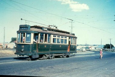
Slide - 35mm slide/s, mid 1950's
Yields information about the Geelong tramway system and one of the terminus and the appearance at the time.Agfachrome Professional plastic mount (blue base, white cover) reproduction slide of a colour slide of Geelong Pengelley No. 18 at East Terminus Ormond and Boundary Roads. Photo shows a child walking away from the tram. Tram has the destination of East. Photographer unknown. Taken on the last day of the first closures, 8/1/1956. See also Reg Item 4389 for a print of this slide. "G 16" and "1 -16" in pencil.tramways, trams, geelong, east, closure, last day, tram 18 -
 Wodonga & District Historical Society Inc
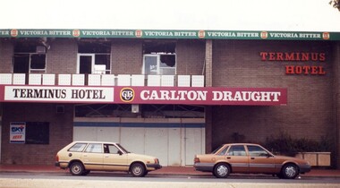
Photograph - Terminus Hotel Wodonga Fire 1998, C. 1998
The Terminus Hotel, Wodonga was built by James Thompson Hatch in 1873, the same year the railway reached Wodonga from Melbourne. It was named due to its close proximity to the railway terminus. It was sold to Messrs George Day and Kenneth McLennan of Albury. It was first licenced to J.G. Morton in January 1874. Annie Allen, from Ireland, took over as licensee of the hotel containing 14 rooms in 1879, after she and her husband, George James Allen, purchased it. In 1887 they added a new wing on the south boundary of the property next to Peter McLean’s store at 81 Sydney Road. The architects for the new wing were Gordon and Gordon. A billiard room, a dining room, and 18 other rooms were added on the vacant block of land between the Hotel and the Bank of Victoria. A balcony 6 feet wide was added on the north side. Included in the plans was the latest patent elevator, later known as a dumb waiter. Allen died in 1889 aged 52, and Annie Allen continued to run the Terminus. She later married John G. Haldon and was licensee of the hotel until December 1898 when the licence was transferred to William Carkeek. Carkeek, from Cornwall, arrived in the colony around 1860 and is considered one of the founders of Tallangatta. In November 1903, the license was transferred to Daniel Crawford, then in 1906 it was transferred to Mr Stephen Carkeek. In 1916 it passed into the hands of Mr H. W. Allen of Rutherglen, son of Mr George James Allen. On 1st June 1998 the Terminus Hotel was destroyed by fire. Estimates of damage range from between a conservative $750,000 to as high as $2 million. The remains of the building were demolished in 1999.The Terminus Hotel was one of the earliest hotels in Wodonga with clear links to the establishment of the railway line. It was an important business and meeting place for social gatherings. On 1st June 1998 the Terminus Hotel was destroyed by fire. Estimates of damage range from between a conservative $750,000 to as high as $2 million. The remains of the building were demolished in 1999. These images capture the extent of damage prior to the demolition. -
 Wodonga & District Historical Society Inc
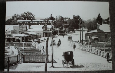
Photograph - Carkeek's Terminus Family Hotel, Wodonga, c1890
The Terminus Hotel, Wodonga was built by James Thompson Hatch in 1873, the same year the railway reached Wodonga from Melbourne. It was named due to its close proximity to the railway terminus. It was sold to Messrs George Day and Kenneth McLennan of Albury. It was first licenced to J.G. Morton in January 1874. Annie Allen, from Ireland, took over as licensee of the hotel containing 14 rooms in 1879, after she and her husband, George James Allen, purchased it. In 1887 they added a new wing on the south boundary of the property next to Peter McLean’s store at 81 Sydney Road. The architects for the new wing were Gordon and Gordon. A billiard room, a dining room, and 18 other rooms were added on the vacant block of land between the Hotel and the Bank of Victoria. A balcony 6 feet wide was added on the north side. Included in the plans was the latest patent elevator, later known as a dumb waiter. Allen died in 1889 aged 52, and Annie Allen continued to run the Terminus. She later married John G. Haldon and was licensee of the hotel until December 1898 when the licence was transferred to William Carkeek. Carkeek, from Cornwall, arrived in the colony around 1860 and is considered one of the founders of Tallangatta. In November 1903, the license was transferred to Daniel Crawford, then in 1906 it was transferred to Mr Stephen Carkeek. In 1916 it passed into the hands of Mr H. W. Allen of Rutherglen, son of Mr George James Allen. On 1st June 1998 the Terminus Hotel was destroyed by fire. Estimates of damage range from between a conservative $750,000 to as high as $2 million. The remains of the building were demolished in 1999.The Terminus Hotel was one of the earliest hotels in Wodonga with clear links to the establishment of the railway line. It was an important business and meeting place for social gatherings.A black and white image printed on canvas. The image includes Carkeek's Terminus Family Hotel in Sydney Road, now named High Street, Wodonga, Victoria. Other businesses shown include a produce store, D.M. Staveley Taylor, John Whan General Store. The railway track can be seen in the foregrounc.Across side of building "CARKEEK'S TERMINUS FAMILY HOTEL" On bottom left "High Street Wodonga 1890s"carkeek, terminus hotel, hotels wodonga -
 Wodonga & District Historical Society Inc
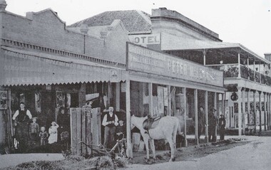
Photograph - Peter McLean's General Store and the Terminus Hotel, Wodonga, C. 1874
The Terminus Hotel, Wodonga was built by James Thompson Hatch in 1873, the same year the railway reached Wodonga from Melbourne. It was named due to its close proximity to the railway terminus. It was sold to Messrs George Day and Kenneth McLennan of Albury. It was first licenced to J.G. Morton in January 1874. Annie Allen, from Ireland, took over as licensee of the hotel containing 14 rooms in 1879, after she and her husband, George James Allen, purchased it. In 1887 they added a new wing on the south boundary of the property next to Peter McLean’s store at 81 Sydney Road. The architects for the new wing were Gordon and Gordon. A billiard room, a dining room, and 18 other rooms were added on the vacant block of land between the Hotel and the Bank of Victoria. A balcony 6 feet wide was added on the north side. Included in the plans was the latest patent elevator, later known as a dumb waiter. Allen died in 1889 aged 52, and Annie Allen continued to run the Terminus. She later married John G. Haldon and was licensee of the hotel until December 1898 when the licence was transferred to William Carkeek. Carkeek, from Cornwall, arrived in the colony around 1860 and is considered one of the founders of Tallangatta. In November 1903, the license was transferred to Daniel Crawford, then in 1906 it was transferred to Mr Stephen Carkeek. In 1916 it passed into the hands of Mr H. W. Allen of Rutherglen, son of Mr George James Allen. Between 1916 and 1933 there were a variety of licensees. In October 1933, the stables and garage at the rear of the Terminus Hotel were totally destroyed by fire. In 1935, the Terminus again underwent a series of improvements and extensions at the cost of £3,000. The front of the premises was extended in the fashionable Spanish mission style. The balcony of brick and concrete was extended to be 18 feet wide, wire gauged and fitted with glass slides and a tile roof. In addition to 15 new bedrooms, four more bathrooms, making seven in all, were available for patrons. These were on the second floor, while beneath them provision was made for four shops and a new kitchen and a laundry. Throughout the 1930s and 1990s the licensee and owners changed several times. On 1st June 1998 the Terminus Hotel was destroyed by fire. Estimates of damage range from between a conservative $750,000 to as high as $2 million. The remains of the building were demolished in 1999.The Terminus Hotel was one of the earliest hotels in Wodonga with clear links to the establishment of the railway line. It was an important business and meeting place for social gatherings.Oldest available photo of the Terminus Hotel beside Peter McLean's Wholesale and Family Drapers General Store. These buildings were on the west side of Sydney Road, later renamed to High Street.hotels wodonga, businesses wodonga, terminus hotel wodonga