Showing 10914 items
matching the land
-
 Bayside Gallery - Bayside City Council Art & Heritage Collection
Map, Department of Lands and Survey, Land under the control of the City of Sandringham, 1962
... Land under the control of the City of Sandringham ...The cadastral map showing land under the control of the City of Brighton in 1962.map, plan, foreshores, sndringham, hampton, beaumaris, cheltenham, department of lands and survey, cartographic material, moorabbin, black rock, street map, city of sandringham, board of lands and works -
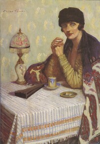 Bendigo Historical Society Inc.
Book - IN A PICTURE LAND OVER THE SEA, c1998
... IN A PICTURE LAND OVER THE SEA ...In a Picture land over the sea. Publisher: Author and Bendigo Art Gallery. Printed by: Print Creations, Bendigo. ISBN:0949215163. 76 pages. Photographs, illustrations some in colour.Karen Quilanart, lifestyle, portrait -
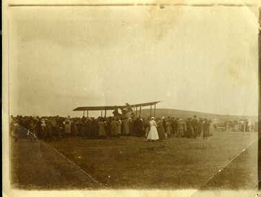 Clunes Museum
Photograph
PHOTO OF FIRST PLANE TO LAND IN CLUNES, NEAR THE OLD HOSPITAL.PHOTOGRAPH / COPY OF AEROPLANE WITH CROWD OF PEOPLE. PHOTOGRAPH OF FIRST PLANE TO LAND IN CLUNESHANDWRITTEN ON BACK - "ONE OF THE FIRST AEROPLANES TO LAND IN CLUNES (IF NOT THE FIRST). LANDED IN PADDOCK ALONGSIDE CLUNES HOSPITAL ON CRESWICK ROAD ABOUT 1920. NOTE NURSE IN UNIFORM."local history, photography, photographs, events and celebrations, first plane to land in clunes -
 Clunes Museum
Document - LAND PURCHASE AGREEMENT, 1862
SIGNED IN MELBOURNE 29TH MARCH 1862 BY SIR HENRY BARKLEY GOVERNOR-IN-CHIEF OF THE COLONY OF VICTORIASALE OF CROWN LAND IN VICTORIA 1862TO ABEL GRENFELL OF CRESWICK. LAND SITUATED IN ALLIANCE STREET, CLUNES.local history, document, land purchase, government, colonial government -
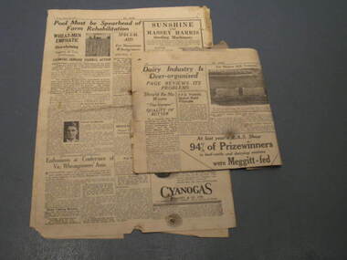 Friends of Westgarthtown
Newspaper, 1935
... the land ...Two newspaper fragments with English text. The Land newspaper, Friday, March 29, 1935. Newspaper seems to address farmer's needs and concerns mainly agricultural interests.As per photo.documents, newspapers, the land, agriculture, newspaper, 1935, english. -
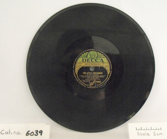 Coal Creek Community Park & Museum
Gramophone Record, Never Never Land / The Little Shoemaker
... Never Never Land / The Little Shoemaker ...Gramophone record, black bakelite with cream and green "Decca" label. Side A: Never Never Land, Side B: The little Shoemaker. Frank Weir & his Saxophone and Orchestra. Vocal by the Michael Twins.Reference Number Y6605 -
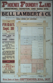 Federation University Historical Collection
Photograph - Colour, Photograph of the Phoenix Foundry Land Sale Poster, 1907, 1907
... Photograph of the Phoenix Foundry Land Sale Poster, 1907 ...Photograph of a poster advertising the auction of Phoenix Foundry Land located on the corner of Armstrong, Doveton and Dana Streets in Ballarat held on 20 September 1907 by Bell, Lambert and Co., auctioneers of Lydiard Street, Ballarat.phoenix foundry, ballarat, newton's hotel, coles and pullum, sale yards, snow's corner, bazaar hotel, stork hotel, jordon and tippett, reid's stables, town hall hotel, mead and co, smith, mather, gazzard, coffee palace, whykes, dimond building, rowland's factory, hunter, hunter daniel & co, ballarat brewing company, tulloch, armstrong street south, doveton street south, dana street -
Port Melbourne Historical & Preservation Society
Legal Record, Act to authorise The Melbourne and Hobsons Bay Railway Company to sell their undertaking and property and to vest the same in the Board of Land and Works for other purposes, 20 Jan 1853
... same in the Board of Land and Works for other purposes ...Victorian Parliamentary Act "to authorise The Melbourne and Hobsons Bay Railway Company to sell their undertaking and property and to vest the same in the Board of Land and Works for other purposes" 14 November 1878: 13pp photocopy of Acttransport - railways, parks and gardens, melbourne & hobsons bay railway company, melbourne & hobsons bay united railway company -
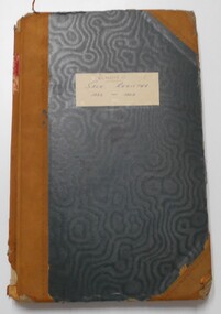 Bendigo Historical Society Inc.
Document - LAND SALES REGISTER - 1882 - 1909, 1882 - 1909
Journal: Hard cover journal, dark green cover with buff corners and spine. Land Sales by auction 1882 - 1909. The sale of land in the following areas: Sandhurst, Bendigo, Heathcote, Shepparton, Inglewood, Rushworth. On front cover label (light buff) in blue ink, Bendigo, Sale Register, 1882 - 1909. On spine red label with gold lettering: Report of sales by auction.Land Sales Officeland sales, bendigo, sandhurst, auctions, sales register -
 Bacchus Marsh & District Historical Society
Map, Atkins and Clarke Land Sale situate at Bacchus Marsh 1856 Copy 2
This plan of land allotments for sale indicates the property once owned by the Bacchus family in and around the township area of Bacchus Marsh. The Bacchus family sold their property in Bacchus Marsh to John Atkins and Robert Nalder Clarke in March 1851. Atkins and Clarke kept the property for a number of years until April 1856 when these allotments were put up for sale.This plan is almost identical to another copy held by the Bacchus Marsh and District Historical Society, VC Record 707, BMDHS collection). This plan, VC Record 452 Copy 2, contains a less detail than than VC Record 707 Copy 1. For example the selling agents and the surveyor who created the plan are not indicated on this copy of the plan. This copy of the plan does indicate the name Crook Street on the map. As the Crook family were the buyers of the Manor House property and surrounding land from Atkins and Clarke in 1856 it suggests that this copy is a later one of the earlier version. It is unlikely that the Crook family would have had the adjacent street named after them prior to purchasing the house and property. This is a very early land sales plan for the township of Bacchus Marsh and it therefore provides some clues as to how the early urban development of the township took place. Upon seeing the map in 1911 Bacchus Marsh Express newspaper editor Christopher Crisp wrote "The sale appears to have created the present township, which had a nucleus in earlier times further east", Express, 30 September, 1911, page 3. A single page paper map showing a portions of land available for sale in Bacchus Marsh in 1856. The subdivided land shown was owned by John Atkins and Robert Nalder Clarke, but previously owned by the Bacchus Family and was in and around their Manor House (Mansion) property in Bacchus Marsh.There are 5 portions of land further divided into numerous small portions. The land for sale is bounded by the present day streets of Main Street, Young Street, McFarland Street, Morton Streets, Crook Street, and part of the eastern section extends to the Lerderderg River. Scale: 4 chains to 1 inch. The map is pasted into a bound volume containing 76 maps or plans in total. High resolution digital image stored on BMDHS computer network. Plan of the first portion of land. The property of Messers Atkins and Clarke situate at Bacchus Marsh.land sales, land sales bacchus marsh, manor house bacchus marsh, crook family bacchus marsh -
Tatura Irrigation & Wartime Camps Museum
Document, From the Holy Land to the Home of the Kangaroo by Walter Stenner
... From the Holy Land to the Home of the Kangaroo by Walter ...Copy of a diary kept by Walter Odorich STENNER, a monk of the Roman Catholic Church. He was taken into custody in Jerusalem by the British Administration of Palestine and interned. This his account of time interned.180 pages in plastic sleeves.walter stenner, roman catholic monks, palestine internees -
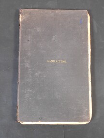 Bendigo Historical Society Inc.
Legal record - Land Act 1901
Black hardcover book. Land Act 1901 in gold letters on the font. The book has 286 pages with few handwritten notes attached to the pages.Land Act 1901 on the coverland act 1901, legal record -
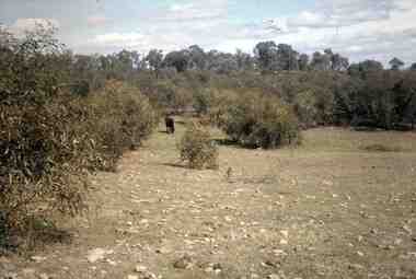 Bendigo Historical Society Inc.
Slide - RALPH BIRRELL COLLECTION: EIG SCHOOL, c1966
... Applied Science. Cow grazing on site. idea of what the ...EIG School - Ralph Birrell Collection. - Construction of Latrobe Uni. C1966. Bendigo Institute of Technology, Engineering School, Applied Science. Cow grazing on site or nearby site. Gives a good idea of what the land was used for prior to construction.Kodakeducation, tertiary, latrobe university bendigo, eig school - ralph birrell collection. - construction of latrobe uni. c1966. bendigo institute of technology, engineering school, applied science. cow grazing on site. idea of what the land was used -
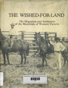 Narre Warren and District Family History Group
Book, WG Manifold, The wished-for-land : the migration and settlement of the Manifolds of western Victoria, 1984
... The wished-for-land : the migration and settlement of the ...History of family settlement near Geelong; includes references to incidents involving Jackey Jackey and Gowin Gowin.non-fictionHistory of family settlement near Geelong; includes references to incidents involving Jackey Jackey and Gowin Gowin.manifold family, geelong (vic.) -
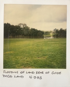 Kew Historical Society Inc
Photograph - Flooding at parkland at rear of Guide Dogs Victoria, 1993
The land currently occupied by Guide Dogs Victoria was once part of the grounds of the Kew Lunatic Asylum. This includes the land, designated as parkland which adjoins the Yarra River. It is now designated as the Chandler Park.Original colour small format polaroid photograph of flooding in parkland at the rear of Guide Dogs Victoria in the area now used as the Main Yarra Trail; taken on 16 September 1993."Flooding of land rear of Guide Dogs land 16.9.93"yarra river -- floods -- kew (vic.), guide dogs victoria, main yarra trail, chandler park -
Whitehorse Historical Society Inc.
Article, Rating on unimproved land values, 1911
A letter from 'Ratepayer' in the Open Column of the Reporter (Box Hill).A letter from 'Ratepayer' in the Open Column of the Reporter (Box Hill) .A letter from 'Ratepayer' in the Open Column of the Reporter (Box Hill). shire of nunawading, mitcham road mitcham, whitehorse road mitcham, station street mitcham -
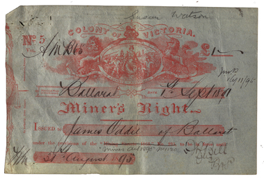 Federation University Historical Collection
Document - Miner's Right, Colony of Victoria, Miner's Right for the Ballarat Observatory Land in Magpie Street, 1890-1899
... Miner's Right for the Ballarat Observatory Land in Magpie ...The Ballarat Observatory was established by James Oddie. It was later given to the Ballarat School of Mines, then the City of Ballarat.A number of Miners' Rights made out to James Oddie of Ballarat, for a block of land in Magpie Street, Mount Pleasant, used as the Ballarat Observatory. The red 1995 Miners' Right includes land at Dana Street with red writing over it regarding its transferal. The Observatory Registration in No 19578 with the situation of residence area being 'Magpie Street Mount Pleasant 209 feet x 52 feet" The District and Division is Central D Ballarat. The red Miners' Right includes the Magpie Ste Address and "Dana Street allot 3 Sec 52 40 feet and 140 feet in Ballarat Central D". In red ink over the address in written (Ressarell) transferred in favor of Susan Watson 7/1/95 C.H. Stevenson Asst M.R. miner's right, james oddie, ballarat observatory, magpie st, mount pleasant, f. bell, w.a. christy, dana street -
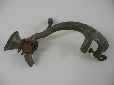 Bendigo Historical Society Inc.
Tool - FOOD MINCER
Cast iron food mincer for seeding raisins, with handle & screw attachment for securing to bench or table, black wooden handle. Marked Landers Frary & Clark New Britain Conn. USA. Pat Nov 24.96 Wet the Raisins No 4 Crown.Landers Frary & Clarkdomestic equipment, food preparation, raisin seeder, k195 -
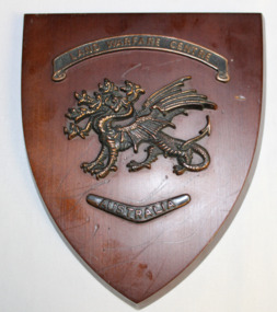 Dandenong/Cranbourne RSL Sub Branch
Land Warfare Centre plaque
Shield shaped plaque made on a red varnished wood with a copper badge of a seven headed dragon affixed to the centre above the dragon is a banner with " Land Warfare Centre" and below it is a boomerang pointed down with "Australia" on inLand Warfare Centre--- Australia -
Ringwood and District Historical Society
Newspaper Cutting, The Sun, Ringwood Development article (Sun Newspaper) 23 Aug 1960, 23-Aug-60
Article about land 'frieze' of the 16 acres of land for the proposed development site for Eastland.Article about Ringwood development in Sun newspaper. Double page. +Additional Keywords: Lavis, A.G., Mayor / Dwerryhouse, F.P., Town ClerkLand 'Frieze' at Ringwood. -
4th/19th Prince of Wales's Light Horse Regiment Unit History Room
Book, Joseph Wones Ltd, Land Rover Series IIA Owner's Manual, Oct 1962
Manual for vehicles used by the RegimentSoft covered owner's manual for the Land Rover Series II A.Land Rover Series IIA Part No 4482 'Regular', 'Long' and Forward Control Owner's Manual user manual, land rover -
Whitehorse Historical Society Inc.
Document, Robert Collier Land, 1903
50 acres and house in Canterbury Road Blackburn to I.N. Cuttle for (pounds)590Papers relating to land dealings by Robert Collier of Springvale Road Tunstall. 50 acres and house in Canterbury Road Blackburn to I.N. Cuttle for (pounds)590collier, robert, t.r.b morton & coghill, maddock & jamison, canterbury road blackburn, freehold investment company of australia ltd -
Tatura Irrigation & Wartime Camps Museum
Booklet, Making A Crust In The Depression and Entertaining Ourselves When Young, 1991
... life on the land ...Stories of life on the land, early 1900's and how the young people entertained themselves,White booklet, black lettering, stories of early farming and fruit growing. Kyabram and Lancaster area.farming in the 1900's, life on the land -
Bendigo Historical Society Inc.
Book - REPORT ON THE NORTH CENTRAL STUDY AREA OF VICTORIA
252 page Report on the North Central Study Area by the Land Conservation Council of Victoria - July 1978 Illustrated with B&W photos Back section contains several removeable maps. Printed by F D Atkinson, Government Printer, MelbourneLand Conservation Council, Victoria -
 Eltham District Historical Society Inc
Ledger, Eltham Road District. Assessment for the Year ending Oct. 14th, 1859, 1858c
The Eltham Roads Board was established in 1856. This ledger includes the signature of Road Board Secretary and Collector Wingrove, a significant person in Eltham's early history. This is a unique significant record of early settlers in the Shire of Eltham. One of 6 early rate books. This is among the oldest items in the EDHS collection. An article in the Eltham and Whittlesea Shires Advertiser Friday 21 Nov 1941 Page 5 titled: District's Early History states: "The first rate book which is still in existence at the Shire Office is for the year ending October 14, 1858 and is probably the best record possible to indicate the development of the district. At the time properties were rated as follows: Cultivated land. 6d. per acre; pasture land, 1d. per acre: estimated annual value of buildings, etc., 6d in the (pound). The total amount of rate recorded for the year was (pounds)153/14/8. Properties were described as being situated at Lower Plenty, Yarra Yarra, Eltham, Lower Eltham, Kangaroo Ground, Yarra Flats, Diamond Creek and the Yarra."Ledger with printed columns: Number, Name of Occupier, Description, Where situated, Cultivated land, Pasture land, Estimated annual value of buildings, Rate, Remarks, Arrears collected, excused, unoccupied, uncollected and amount actually collected. Ledger filled out by hand with 173 entries (not alphabetically arranged). A number of blank pages are included. Inside cover includes pasted printed note: RATE OF ASSESSMENT AS FOLLOWS: Cultivated land 6d per acre Pasture land 2d per acre Unalienated Pasture Land 8d per Acre Estimated Annual Value of Buildings, &c., 6d. in the Pound eltham roads board, rate book, rate payers, transaction, pioneers, settlers, wingrove, 1859, assessment ledger, eltham road district, public records office victoria (prov), rate books, shire of eltham archives -
 Eltham District Historical Society Inc
Ledger, Eltham Road District. Assessment for the Year ending Oct. 14th, 1860 (Version 1), 1859c
The Eltham Roads Board was established in 1856. This is a unique significant record of early settlers in the Shire of Eltham. One of 6 early rate books. This is among the oldest items in the EDHS collection. An article in the Eltham and Whittlesea Shires Advertiser Friday 21 Nov 1941 Page 5 titled: District's Early History states: "The first rate book which is still in existence at the Shire Office is for the year ending October 14, 1858 and is probably the best record possible to indicate the development of the district. At the time properties were rated as follows: Cultivated land. 6d. per acre; pasture land, 1d. per acre: estimated annual value of buildings, etc., 6d in the (pound). The total amount of rate recorded for the year was (pounds)153/14/8. Properties were described as being situated at Lower Plenty, Yarra Yarra, Eltham, Lower Eltham, Kangaroo Ground, Yarra Flats, Diamond Creek and the Yarra."Ledger with printed columns: Number, Name of Occupier, Description, Where situated, Cultivated land, Pasture land, Estimated annual value of buildings, Rate, Remarks, Arrears collected, excused, unoccupied, uncollected and amount actually collected. Ledger filled out by hand with 177 entries (not alphabetically arranged). A number of blank pages are included. Inside cover includes pasted printed note: RATE OF ASSESSMENT AS FOLLOWS: Cultivated land 6d per acre Pasture land 2d per acre Unalienated Pasture Land 8d per Acre Estimated Annual Value of Buildings, &c., 6d. in the Pound eltham roads board, rate book, rate payers, transaction, pioneers, settlers, wingrove, 1860, assessment ledger, eltham road district, public records office victoria (prov), rate books, shire of eltham archives -
 Eltham District Historical Society Inc
Ledger, Eltham Road District. Assessment for the Year ending Oct. 14th, 1861, 1860c
The Eltham Roads Board was established in 1856. This is a unique significant record of early settlers in the Shire of Eltham. One of 6 early rate books. This is among the oldest items in the EDHS collection. An article in the Eltham and Whittlesea Shires Advertiser Friday 21 Nov 1941 Page 5 titled: District's Early History states: "The first rate book which is still in existence at the Shire Office is for the year ending October 14, 1858 and is probably the best record possible to indicate the development of the district. At the time properties were rated as follows: Cultivated land. 6d. per acre; pasture land, 1d. per acre: estimated annual value of buildings, etc., 6d in the (pound). The total amount of rate recorded for the year was (pounds)153/14/8. Properties were described as being situated at Lower Plenty, Yarra Yarra, Eltham, Lower Eltham, Kangaroo Ground, Yarra Flats, Diamond Creek and the Yarra."Ledger with printed columns: Number, Name of Occupier, Description, Where situated, Cultivated land, Pasture land, Estimated annual value of buildings, Rate, Remarks, Arrears collected, excused, unoccupied, uncollected and amount actually collected. Ledger filled out by hand with 185 entries (not alphabetically arranged) and summary section. A number of blank pages are included. Inside cover includes pasted printed note: RATE OF ASSESSMENT AS FOLLOWS: Cultivated land 6d per acre Pasture land 2d per acre Unalienated Pasture Land 8d per Acre Estimated Annual Value of Buildings, &c., 6d. in the Pound eltham roads board, rate book, rate payers, transaction, pioneers, settlers, 1861, assessment ledger, eltham road district, public records office victoria (prov), rate books, shire of eltham archives -
 Bendigo Historical Society Inc.
Document - PRINTED NOTE PAD FOR LAND VALUATION
Note pad. Eleven blank land valuation worksheets for the Land Commission. Each valuation comprises 3 separate pages to record Lessee's and Commission's improvements plus stock, implements and other assets. Some of these pages have been used to record other items not related to the above. Handwritten in ink as follows. (1) Royal Historical Society of Victoria - notes on general index codes. (2) Snobs Hill Rovers football club 1904 - some 50 names. (3) Officers and members of the Hopetoun Brass Band, Bendigo as at 14 Feb 1913 - Name No.473 is Sir John Quick. Name No. 497 is J. Michell, bandmaster. Ends at Name No.522. (4) Eaglehawk Pioneers - Name nos.523 to 618. Each name has a year beside it ranging from 1846 ? (J.Mouatt) to 1863. (5) One page list of Regional Parishes each with a date and number, (crossed out in pencil).Land Commission ?government, state, land commission, valuation notepad, snobs hill rovers football club, hopetoun brass band, eaglehawk pioneers, regional parishes, index codes for royal historical society of victoria -
 Eltham District Historical Society Inc
Ledger, Eltham Road District. Assessment for the Year ending Oct. 14th, 1862, 1861c
The Eltham Roads Board was established in 1856. This is a unique significant record of early settlers in the Shire of Eltham. One of 6 early rate books. This is among the oldest items in the EDHS collection. An article in the Eltham and Whittlesea Shires Advertiser Friday 21 Nov 1941 Page 5 titled: District's Early History states: "The first rate book which is still in existence at the Shire Office is for the year ending October 14, 1858 and is probably the best record possible to indicate the development of the district. At the time properties were rated as follows: Cultivated land. 6d. per acre; pasture land, 1d. per acre: estimated annual value of buildings, etc., 6d in the (pound). The total amount of rate recorded for the year was (pounds)153/14/8. Properties were described as being situated at Lower Plenty, Yarra Yarra, Eltham, Lower Eltham, Kangaroo Ground, Yarra Flats, Diamond Creek and the Yarra."Ledger with printed columns: Number, Name of Occupier, Description, Where situated, Cultivated land, Pasture land, Estimated annual value of buildings, Rate, Remarks, Arrears collected, excused, unoccupied, uncollected and amount actually collected. Ledger filled out by hand with 184 entries (not alphabetically arranged) and summary section. A number of blank pages are included. Inside cover includes pasted printed note: RATE OF ASSESSMENT AS FOLLOWS: Cultivated land 6d per acre Pasture land 1/2d per acre Unalienated Pasture Land 1/28 per Acre Estimated Annual Value of Buildings, &c., 6d. in the Pound eltham roads board, rate book, rate payers, transaction, pioneers, settlers, 1862, assessment ledger, eltham road district, public records office victoria (prov), rate books, shire of eltham archives -
 Eltham District Historical Society Inc
Ledger, Eltham Road District. Assessment for the Year ending Oct. 14th, 1863, 1862c
The Eltham Roads Board was established in 1856. This is a unique significant record of early settlers in the Shire of Eltham. One of 6 early rate books. This is among the oldest items in the EDHS collection. An article in the Eltham and Whittlesea Shires Advertiser Friday 21 Nov 1941 Page 5 titled: District's Early History states: "The first rate book which is still in existence at the Shire Office is for the year ending October 14, 1858 and is probably the best record possible to indicate the development of the district. At the time properties were rated as follows: Cultivated land. 6d. per acre; pasture land, 1d. per acre: estimated annual value of buildings, etc., 6d in the (pound). The total amount of rate recorded for the year was (pounds)153/14/8. Properties were described as being situated at Lower Plenty, Yarra Yarra, Eltham, Lower Eltham, Kangaroo Ground, Yarra Flats, Diamond Creek and the Yarra."Ledger with printed columns: Number, Name of Occupier, Description, Where situated, Cultivated land, Pasture land, Estimated annual value of buildings, Rate, Remarks, Arrears collected, excused, unoccupied, uncollected and amount actually collected. Ledger filled out by hand with 181 entries (not alphabetically arranged) and summary section. A number of blank pages are included. Inside cover includes pasted printed note: RATE OF ASSESSMENT AS FOLLOWS: Cultivated land 6d per acre Pasture land 1/2d per acre Unalienated Pasture Land 1/28 per Acre Estimated Annual Value of Buildings, &c., 6d. in the Pound eltham roads board, rate book, rate payers, transaction, pioneers, settlers, 1863, assessment ledger, eltham road district, public records office victoria (prov), rate books, shire of eltham archives