Showing 9698 items
matching the road back
-
 Orbost & District Historical Society
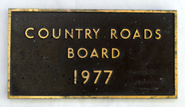
plaque, 1977
The Country Roads Board was the government authority for the construction and maintenance of main roads in Victoria between 1913 and 1983. It was succeeded by the Road Construction authority on 1 July 1983 and later merged with the Road Traffic Authority on July 1 1989 to form the Roads Corporation. James Cameron, an Orbost farming pioneer and Member of the Legislative Assembly, fathered the Country Roads Board. This plaque was possibly removed from a bridge(?) when the name was changed.A heavy rectangular shaped bronze plaque. the background is dark brown and the print and frame bronze coloured. On the back are two round recesses for screwing and attaching the plaque.COUNTRY ROADS BOARD 1977country-roads-board cameron-james -
 Orbost & District Historical Society
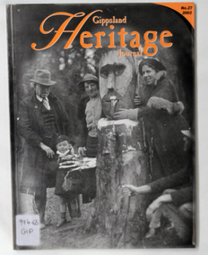
journals, Gippsland Heritage Journal, 2003
Gippsland Heritage Journal is a journal, produced about every nine - twelve months, for those interested in regional, local and family history in Gippsland, Victoria, Australia. It is compiled by Meredith Fletcher, Debbie Squires and Linda Barraclough and includes a diverse range of articles, both academic and non-academic. This issue has been edited by Meredith Fletcher.This item is a useful reference for the history of Gippsland.A 64 pp magazine, plastic covered, titled Gippsland Heritage Journal. The front cover is orange with a b/w photograph of Mr Stringy at Dead Horse Flat on the Omeo Road c 1937. The magazine contains photographs, articles on the history of Gippsland.On back - library barcode and price sticker - $13.20. On the front cover is a call no. 996.65 GIP journal-gippsland-heritage-journal history-gippsland mr-stringy-omeo -
 Orbost & District Historical Society
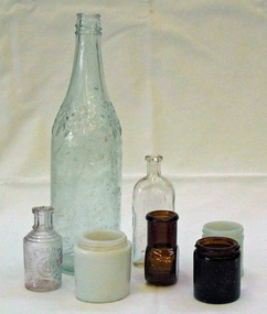
bottles, early 20th century
these bottles were found at the old pine plantation near Forest Road Orbost.These various shaped containers are examples of glass containers used in the early 20th century.Seven bottles found at old pine plantation in north of Orbost. 2372.1 is a cylindrical Vegemite jar made of white opal glass. It has a threaded rim and two mould seams. 2372.2 is a brown beef extract jar. 2372.3 is a rounded square white Ponds jar which would have had a metal lid. 2372.4 is a brown Bovril jar and probably had a cork seal. 2372.5 is a clear perfume bottle from Rogers & Gallet Paris. It has concentric circles around the neck and a star pattern on the base.. 2372.6 is a clear glass medical bottle used by Bosisto and 2372.7 is a clear glass cordial bottle from O.T. ltd.2372.1: on base AGM above V905 above 6 2372.2: GLOBEX AGM X3 with Beef Extract on sides 2372.3 - on base PONDS with logo 2372.4 - on side- 2oz BOVRIL LIMITED F204 2372.5 - ROGERS & GALLET logo PARIS 2372.6 - on bottom - AGM ; in indented rectangle on back - BOSISTO & CO Pty Ltd. 2372.7 - at bottom - PROPERTY of O.T. LTD; on base - AGM logo F1151 M F?bottles containers jars vegemite-jar bovril-jar bosito's-bottle pond's-jar -
 Orbost & District Historical Society
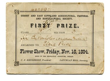
certificate/award, 1894
Orbost and East Gippsland Agricultural, Pastoral & Horticultural Society held their annual show in the Mechanics' Institute hall in Orrbost on November 16, 1894. First Prize in Class F Section C was awarded to Elsie Price for "six buttonholes (children under 14)". At this time C.N. Henderson was President and Lauchlan Ross was Secretary. The first meeting to form an Agricultural society in Orbost was convened by the then Orbost Progress Association and held in the Mechanics Hall on Saturday, 10th October 1891. Its first show was held on 3rd March 1904, on a site alongside the Bonang Road where the present Golf Club stands. It is currently held at the Recreation Reserve at Newmerella. Ref: In Times Gone By-Deborah Hall Prior to the Orbost Agricultural Society 's Annual Show these smaller shows were held in the Mechanics' Institute hall. Elsie Price, 1886-1897, was the daughter of David J and Mary Faithfull.This item is associated with the Orbost Agricultural Society 's Annual Show which has been a major event in Orbost for over a century.A original rectangular white paper certificate. Text is inside a border- all print is black. Details are handwritten.On back - many names. On front -"Mrs Price"award agricultural-show public-event -
 Orbost & District Historical Society
photographs, Lawless, Ray
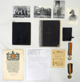
These photographs are part of the Lawless Collection. The Lawless family lived in Orbost from 1907 - c 1920. John Francis Lawless had a saddlery shop. He died at an early age - 47 years - June 7 1912, leaving his wife, Elizabeth and seven children. The eldest son, Victor Rowland lawless volunteered for serv ice in WW1 but did not leave Australia because of illness. The second son, Edward Vincent Lawless (b 1895 d 1917) worked for McCoy & Co. in Orbost, coachbuilding, undertakers, general blacksmiths and farriers, prior to enlisting in WW!. He was trained as a signaller and was sent to France where he was killed in action on 9.10.1917. Elizabeth Lawless worked as a ladies' nurse (midwife) in Orbost prior to leaving the district in 1920. She lived to 6.6.1975 aged 104 years.These personal documents, photographs and books give an insight into the human element of World War 1 ensuring that those who were part of the Orbost community and died while playing a vital role during this time are remembered.Four black and white copies of photographs of the Lawless family. 1846.8 is a photograph of Ted Lawless. 1846.9 is a photograph of Ruby Lawless Wallace and Ray Lawless at Elizabeth Lawless' house. 1846.10 is a photograph of the Lawless family at the Boundary Road house in Orbost.1846.8 on back - Ted Lawless 1846.9 on back - Ruby Lawless 1846.10 on back - Family with Elizabeth 1846.11 on back - Grandmother 21st Battalion Wallace wife at Home Boundary Rd Lawless AIF & Ray at Grandma Orbost Lawless House It is still there Orbost? Ray Lawless June 2010photographs lawless-family -
 Orbost & District Historical Society
lantern
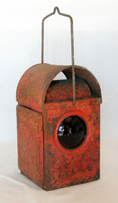
The kerosene lantern is a type of lighting device that uses kerosene as a fuel. Kerosene lanterns have a wick or mantle as light source. They may be hand-held for portable lighting.This kerosene lantern was used as a light on road works in the Orbost area. It would have been carried/used by one of the road workers. Lamps of this kind were significantroadworks items in their period of use as essential tools to the safe-working operations of the Country Roads Board.. A red metal roadworks warning lantern. It is rectangular with a metal carrying handle. The top is domed. The door at the back is hingedand opens with a small nail. The lamp was lit by kerosene held in a small square tank with a wick.lantern kerosene light lamp -
 Orbost & District Historical Society
black and white photograph, first half 20th century
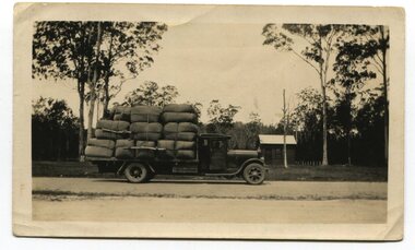
The photograph shows a loaded truck outside the Noorinbee Store. This is a pictorial record of early road transport in East Gippsland.A black / white photograph of a large truck loaded with large bundles. It is in front of a small store at Noorinbee on the main road.on back - "in front of Noorinbee Store"transport noorinbee -
 Orbost & District Historical Society
black and white photograph, 1911
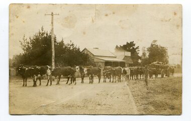
This photo shows Jas Lynn of Orbost driving a team of bullocks pulling a large cart of maize. They are taking it to the fisherman's Wharf in Lakes Entrance. Maize has been grown on the Orbost flats since the late 19th century. Transport was always an obstacle to economic sucess. For a few years prior to the First World War and the construction of the railway line from Bairnsdale to Orbost, a lot of maize was carted by horse and bullock teams to Lakes Entrance for transhipment to the Melbourne market. At that .time yields of 90 to 100 bushels of maize were quite a common occurrence. James Lynn, a member of the East Gippsland Maize Board, farmed at Jarrahmond.This photograph is associated with the large maize growing industry in the Orbost region. A black / white photograph of a bullock team pulling a large, loaded cart. It is being driven by a man standing on the side of the road, holding a whip. In the background are houses and a telegraph pole.on back - " Carting maize to Lakes Entrance in 1911."transport-bullocks maize-orbost lynn-james -
 Orbost & District Historical Society
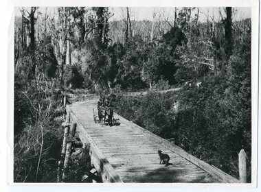
black and white photograph, 1913
... on back - "Country Roads Board Princes Highway low level..., East Gippsland. on back - "Country Roads Board Princes Highway ...This photograph is of the low level bridge across the Bemm River about 50 km east of Orbost in East Gippsland.This is a pictorial record of the 1913 low level bridge across the Bemm River, East Gippsland.A large black / white photograph of a horse - drawn wagon on the low level Bemm River bridge. In the foreground on the bridge is a dog.on back - "Country Roads Board Princes Highway low level bridge" -
 Orbost & District Historical Society
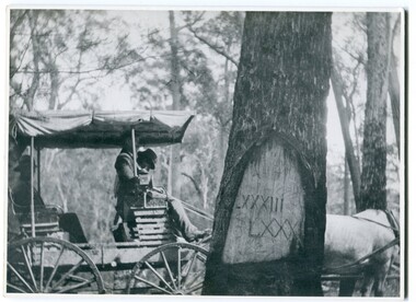
black and white photograph, 1913
When marking a boundary for a registered plan, a surveyor would place “Reference Marks” with a stated bearing and distance to a boundary corner. These trees were typically marked by cutting the bark of the tree in a shield or blaze. Until July 1886, surveyors were only able to use trees as reference marks to boundary corners. After July 1886 surveyors were able to use “permanent marks” which were either a glass bottle, gas pipe or iron bolt (for homestead surveys only). This photograph shows the reference tree, 83 miles from Marlo via the original surveyed road v ia Sydenham Inlet and Tamboon, south of Mount Drummer to the New South Wales border - now the Princes Highway.This is a pictorial record of an old survet tree. Knowledge of their location, abundance and condition not only provide important insights to past survey practice, but also provide a lasting legacy of a regions land-use history. Old survey trees serve as one of the few remaining physical legacies of early European land settlement history.A large black / white photograph of a horse and buggy pulled up alongside a reference tree which has notches and markings of Roman numerals.on back - " Refernce tree 83 miles from Marlo........to N.S.W. Border"survey-tree reference-tree -
 Orbost & District Historical Society
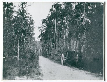
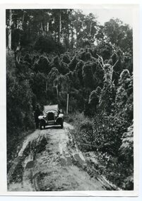
black and white photograph, 1913
This photograph shows the regrowth of vegetation on the road between Genoa and the border - now the Princes Highway.This is a pictorial record of the main road from Orbost to the New South border, The Princes Highway, in the early 20th century.A large black / white photograph of a bush road wwith a vehicle and a man on the side of it.on back - " Princes Highway showing the regrowth.....1913"princes-highway-genoa transport -
 Orbost & District Historical Society
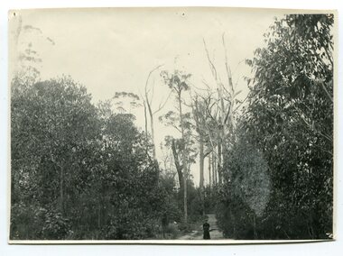
black and white photograph, May 1897
... / Brodribb Road. orbost-brodribb-road on back - " Track near Orbost ...Photo shows an unidentified lady standing on the Orbost / Brodribb Road.A black / white photograph of a women in a long dress standing on a bush road surrounded by dense scrub.on back - " Track near Orbost / Brodribb Road, May 1897"orbost-brodribb-road -
 Orbost & District Historical Society
black and white photograph, 1924
History unknown. Oswald Stuart Green taught at the Bete Bolong State School in the 1920s /30s. He wrote many books about East Gippsland including several on thee Orbost / Marlo district.Oswald Green has an association with the Orbost area.A black / white photograph of a dirt road in the bush with a motor vehicle on the road and a man standing beside it.on back - " O.S. Green 31 Malcolm St Blackburn Princes Highway east of Coolwater Creek."princes-highway-coolwater-creek green-oswald-stuart -
 Orbost & District Historical Society
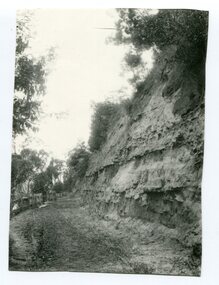
Photograph - Hofen's cutting, Bete Bolong, Orbost district, early 20th century
... tracks/roads on back - "Newmerella" (note: this location ...This photograph is of a cutting on a road at Bete Bolong known as Hofen's Cutting. This photograph was taken c. 1906 when transport was by horse, wagon and prior to cars and railways.This is a pictorial record of early Bete Bolong showing a road through a cutting which was known as Hofen's cutting. Two black / white photographs showing a dirt road heading down a cutting with a post and rail wooden fence on the left side in the background. In 958.1 there is a cut - away hillside beside the dirt road.on back - "Newmerella" (note: this location is at Bete Bolong and not on Newmerella Hill) 958.1 - on back - "Hofen's Bluff 1906"bete bolong, orbost, tracks/roads -
 Orbost & District Historical Society
black and white photograph, before 1912
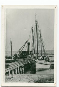
This photo shows the Storm Bird at the end of the jetty and the Wangrabelle in the foreground. Both ships were well known traders. the Wangrabelle became beached and wrecked in 1916 and the Storm Bird became obsolete when the railway from Bairnsdale to Orbost arrived in 1916. (ref. Story of Gippsland Shipping - J.C. Bull) At the start of the river trade goods were shipped from Marlo to Melbourne but when the railway reached Bairnsdale this became unprofitable and the ships plied only between Marlo and Cunninghame. Eventually river transport became economically unviable. The Wongrabelle is still buried in the sands of the entrance of the Snowy River (albeit where the entrance used to be). It took from April 11th 1912 to August 12th 1912 for the loss of the Wongrabelle to be complete, the final entry in the Orbost Shipping Co. records reads:- "The Wongrabelle is completely covered in sand." (ref River, Road, Railway Newsletter O.D.H.S.) This is a pictorial record of a time when the water highways were the only feasible transport mode in sending goods from Orbost and Marlo to Melbourne.A black / white photograph of a ship, sails down, anchored at the Marlo jetty.on back - "M. Gilbert, Wangrabelle at Marlo"storm-bird wangrabelle shipping transport- marlo -
 Orbost & District Historical Society
black and white photographs, September 1914
Broadmeadows was home to the major army training camp for the Australian Imperial Force. The land was previously known as Mornington Park. It was a wide field, suitable for military practice, including training for the Light Horse regiments. It is the current location of the Maygar Army Barracks on Camp Road in Broadmeadows. To reach the camp, soldiers marched from Victoria Barracks in St Kilda Road and headed north up Sydney Road, only resting near Fawkner Cemetery. Soldiers slept in tents and food was basic. Training was hard, but it did not prepare soldiers for a modern war with machine guns, gas, shells and aeroplanes – technology that did not exist in previous wars. Some men only completed a few months training before departing on troopships from Port Melbourne. Once overseas, some soldiers received further training in Egypt. It is likely that these men are associated with the Orbost district.This photograph is a reminder of the personal stories of those who were involved in WW1.Two copies of a black / white photograph on dark grey buff cards. The photos show a group of soldiers having a meal. Some are sitting on the ground with others standing behind them.on back of 989.1 - "Sept 14 Broadmeadows"w.w.1 broadmeadows-army-training-camp -
 Orbost & District Historical Society
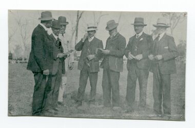
black and white photograph, S.F. Gerberg & Bulmer, C 1908u
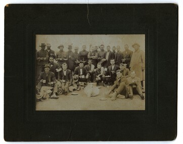
This photograph shows members of the Orbost Agricultural Show committee about 1908 with L to R : S. Lynn; John Russell; Mat Lynch; W. Warren; John Johnson; Will Cumming & Geo. Perry. The first meeting to form an Agricultural society in Orbost was convened by the then Orbost Progress Association and held in the Mechanics Hall on Saturday, 10th October 1891. Its first show was held on 3rd March 1904...on a site alongside the Bonang Road where the present Golf Club stands. It is currently held at the Recreation Reserve at Newmerella. (Ref: In Times Gone By-Deborah Hall) This item is associated with the Orbost Agricultural Society 's Annual Show which has been a major event in Orbost for over a century. Agricultural shows are an important part of cultural life in small country towns and the Orbost Show is an integral part of Orbost 's agricultural history. A faded black / white photograph of seven men standing outside with trees in the background.on back - " Orbost Agricultural Show" and list of men in photograph.orbost-agricultural-society annual-show -
 Orbost & District Historical Society
black and white photograph, 11 February 1971
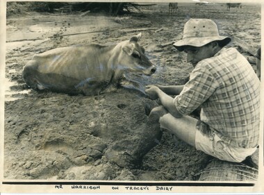
This photograph was taken during the 1971 floods at Orbost. The 1971 flood was the the worst flood on record. At Jarrahmond it was at least 11 metres and up to one and a half kilometres wide on the flats causing enormous damage to the flood plain. Records say that "The brown floodwater stain in Bass Strait could be seen from passing airliners." Considerable damage was done to railway infrastructure, roads and farms. More information from the APRIL, 2008 newsletter by John Phillips. (see orbosthistory.com.au)This is a contemporary pictorial record of a significant local event.A large black / white photograph of a man, dressed in shorts and a checked shirt, sitting on a fence post surrounded by mud. He is holding on to the leg of a cow which is stuck in the mud.on front - "Mr Harrison on Tracey's Dairy" on back - " Herald 11 Feb 1971"floods-orbost-1971 tracey-dairy natural-disaster-flood -
 Orbost & District Historical Society
black and white photograph, first half 20th century
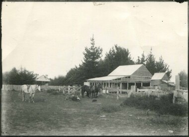
Mr John Watt set up farming in 1879. He was a native of Port Fairy. He was educated in Scotland and came back to Victoria and selected 320 acres on the Snowy River.The property extended from Majors Creek Road to around about Gilbert's Gulch.This is associated with John Watt, a prominent early settler in Orbost.A black / white photograph of a dilapidated farm shed with three horses in the foreground. A house can be seen in the background (left) behind a fence. on back - "Watts Farm"watt-john-orbost farming-buildings -
 Orbost & District Historical Society
black and white photograph, late 19th / early 20th century?
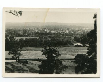
This photograph shows a distant view of the Orbost township taken from Grandview Lookout at Newmerella. It appears to have been taken before the railway line was there.This is a pictorial record of early Orbost.A small black / white photograph of the Orbost township taken from Grandview Lookout , Newmerella. The main road can be seen below with paddocks of crops on both sides.on back - "Distant View, Orbost from Grandview"orbost-township-c19th grandview-lookout orbost-flats-paddocks -
 Orbost & District Historical Society
black and white photograph, 1918
... there was a temporary rush to obtain gold. This road was constructed ...Tonghi Creek is 66km north - west of Orbost. Prior to the sealing of the Princes Highway west of Orbost, the road surface was anything but good, even by C1917 when cars started to use the road. From Orbost the old road via Marlo to Sydenham was abandoned for the new location which traversed more rugged country via Cabbage Tree, Bell Bird and Club Terrace to Cann River, and the reason for this diversion was on account of settlements being established at Murrungowar and Club Terrace, at which latter place there was a temporary rush to obtain gold. This road was constructed by the Public Works department and a maximum grade of 1 in 19 was adopted, and as speed was not to be catered for the grade followed in and out round the spurs and gullies, resulting in a maze of turns and twists which required a good deal of skill on the part of the horse driver to negotiate." - Bairnsdale Advertiser, Friday, May 2, 1947. (More information from Newsletter February 2010)This item is a pictorial record of roads in the early 20th century in East Gippsland.A large black / white photograph of a bridge over a small creek, surrounded by bush. The photograph is mounted on a thick cream coloured card.on back - "Bridge at Tonghi Creek 1918"tonghi-creek-bridge country-roads-east-gippsland -
 Orbost & District Historical Society
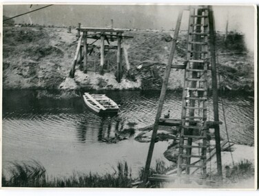
black and white photographs, 1915
This photograph is of the construction of the first road bridge over the Genoa River - 1915. Before today's timber truss and concrete bridge was constructed between 1926-1928 by contractor J.T. Noble Anderson, two earlier bridges crossed the Genoa River at this location. They provided crucial links in the Princes Highway route from Melbourne to Sydney. The letter on the back of the postcard was written by Gordon ? to Alex ? on 2nd October 1917. "this represents the opening of Genoa Bridge. Mrs Alexander cutting the ribbon and Mr Martin holding it at the other side. Did most of the speaking. The gent holding the roll of paper is who came to open the bridge. I can't think of his name. Hubert is standing up at the right / Gordon " This is a pictorial record associated with the history of Genoa in East Gippsland.1100 -A large black / white photograph on a cream coloured buff card. It is of an unfinished bridge with men working there. A small rowboat can be seen on the far side of the river. 1100.1 - A photograph / postcard of the opening of "Genoa Bridge 1917". There is a ribbon stretched across the timber decking road in front of a group of people. 1100.2 - A black / white photograph of a road bridge across a river.on back - "Princes Highway - the 1st bridge over the Genoa River - 1915" on back of 1100.1 is a hand-written letter.genoa-bridge princes-highway-east-gippsland -
 Orbost & District Historical Society
black and white photograph, 1920 - 1930
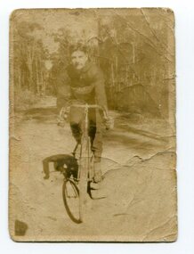
By 1905 there was an Orbost Bicycle Club. E. Donchi was a member and was a successful competitor around 1927. It is likely that the Orbost Cycling Club disbanded during WWI, and evidence from the Snowy River Mail is that it reformed again in 1945. There is no doubt that bikes were a dominant form of personal transport until the 1960s when cars ownership became more common, although children still rode to school. As far as theOrbost Cycling Club was concerned, the golden years were from 1945 to 1950. (information Newsletter August 2018 - Geoff & Lee Stevenson)This item is associated with a popular recreational activity in early Orbost. The period between the First World War and the 1950s was the heyday of cycling. After 1900 the efficient mass production of standardized safe bicycles, as well as the wider availability of second-hand bicycles, caused rapidly dropping prices and it was therefore easier for people to purchase a bicycle not only for utilitarian use but for racing. A small black / white photograph of a young man on a racing bike. It is on an unsealed road in a forest. on back - "E. Donchi, Cyclist, Orbost"donchi cycling-orbost recreation -
 Orbost & District Historical Society
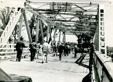
black and white photograph, 1976
This bridge over the Snowy River was opened on July 4 1922. It was constructed in 1922 alongside the previous suspension bridge. Its building was a combined effort of the Victorian Railways and the Country Roads Board at a cost of 35,000 pounds. It was replaced in 1976 by the present bridge after several major floods. This photograph shows people walking over the bridge for the last time.This is a pictorial record of the former Snowy River Bridge at Orbost.A black / white photograph showing a group of people walking across a bridge. There are several cars, a man on a horse and people standing on the side of the roadway.on back - "1976 - old bridge"snowy-river-bridge-1976 -
 Orbost & District Historical Society
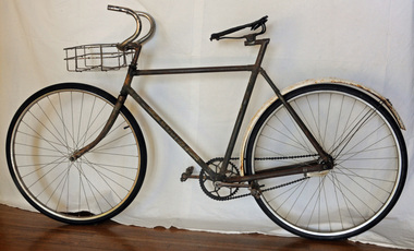
bicycle, 1930's -1940's
This bike belonged to Wally Paten who worked in the Orbost Butter Factory in the 1940's. Wally's father, Thomas Paten came to Orbost in 1893 and began growing fancy seeds in 1907 for H. James. He built the first levee bank in Orbost (ref. Mary Gilbert). The Comet bike was distributed by the Myer Emporium. "Comet:" was their house brand. They also sold the "Peter Pan". It was named "The Comet" probably because it was a fast bike. At the time it was an expensive bike . Ted Waterford made headlines riding Melbourne to Adelaide one way then return on a Comet in 1932.Bicycles have been a part of Australian life for more than 140 years. The bicycle soon began competing with the horse as a convenient and economical way for people to get around. This bicycle is an example of an early style which was used by an Orbost local.A man's road bicycle. It has 26inch wheels, back pedal brakes and has a wire basket attached to the curved handle bars. There is a leather seat in poor condition. The back wheel has a mudguard painted white. The bike is ungeared. This is probably the original frame with newer wheels. The pedals are metal.Tyres - made in Korea down tube -COMETcomet-bicycle bicycle paten-wally transport -
 The Beechworth Burke Museum
Photograph
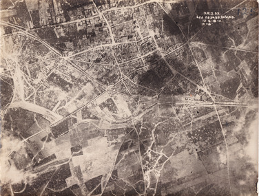
Taken some time between 1914-18, the photograph depicts an aerial view of Villers-Bretonneux in France, a region which was part of the Western Front during World War I. The image mostly shows rural landscape. The Western Front was the main theatre of war during World War I. Following the outbreak of war in August 1914, the German Army opened the Western Front by invading Luxembourg and Belgium, then gaining military control of important industrial regions in France. The German advance was halted with the Battle of the Marne. Following the Race to the Sea, both the French-British and German armies dug in along a meandering line of fortified trenches, stretching from the North Sea to the Swiss frontier with France. The First Battle of Villers-Bretonneux occurred between 30 March - 5 April 1918. It took place during Operation Michael, part of the German Spring Offensive on the Western Front. The offensive began against the British Fifth Army and the Third Army on the Somme, and pushed back the British and French reinforcements on the north side of the Somme. The capture of Villers-Bretonneux, close to Amiens, a strategically important road and rail-junction, would have brought the Germans within artillery-range. In late March, troops from the Australian Imperial Force were brought south from Belgium as reinforcements to help shore up the line. In early April, the Germans launched an attack to capture Villers-Bretonneux. After a determined defence by British and Australian troops, the attackers were close to success until a counter-attack by the 9th Australian Infantry Brigade and British troops late in the afternoon of 4 April restored the situation and halted the German advance on Amiens. The Second Battle of Villers-Bretonneux occurred between 24 - 27 April 1918, during the German Spring Offensive to the east of Amiens. It is notable for being the first occasion on which tanks fought against each other. A counter-attack by two Australian brigades and a British brigade during the night of 24 April partly surrounded Villers-Bretonneux, and on 25 April, the town was recaptured. On 26 April, the role of the Moroccan division of the French army was crucial in pushing back German units. Australian, British and French troops nearly restored the original front line by 27 April.The record is historically significant due to its connection to World War I. This conflict is integral to Australian culture as it was the single greatest loss of life and the greatest repatriation of casualties in the country's history. Australia’s involvement in the First World War began when the Australian government established the Australian Imperial Force (AIF) in August 1914. Immediately, men were recruited to serve the British Empire in the Middle East and on the Western Front. Additionally, the record's significance is enhanced by its depiction of Villers-Bretonneux. The battles that occurred in this town during World War I are especially historically significant to Australia as this is where the Australian Imperial Force had one their greatest World War I victories. An Australian flag still flies over Villers-Bretonneux in the present. Furthermore, a plaque outside the Villers-Bretonneux Town Hall recounts the battles fought to save the town in 1918. Kangaroos feature over the entrance to the Town Hall, and the main street is named Rue de Melbourne. More officially, recognition of the significance of the battle in Villers-Bretonneux is found at the Australian National Memorial, which was built just outside the town. It commemorates all Australians who fought in France and Belgium and includes the names of 10,772 who died in France and have no known grave. Each year, a small ceremony is held at the memorial to mark the sacrifice made by the soldiers. Lastly, the record has strong research potential. This is due to the ongoing public and scholarly interest in war, history, and especially the ANZAC legend, which is commemorated annually on 25 April, known as ANZAC Day.Sepia rectangular photograph printed on matte photographic paper.Obverse: yAE.2.35. / 125 / 62d.2834.35.36.VA.5. / 12.G.18-11 / F.-(?)" /military album, wwi, world war i, villers-bretonneux, australian imperial force, aif, france, war, army, conflict, germany, 1918, battle -
 Flagstaff Hill Maritime Museum and Village
Tool - Draw Knife, Prior to 1950
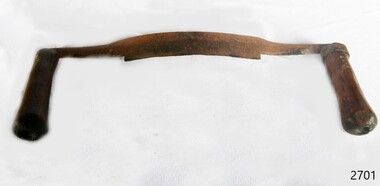
A draw knife or drawing knife, draw shave, shaving knife is a traditional woodworking hand tool used to shape wood by removing shavings. It consists of a blade with a handle at each end. The blade is much longer along the cutting edge than it is deep (from cutting edge to back edge). It is pulled or "drawn" toward the user. A draw knife is commonly used to remove large slices of wood for flat faceted work, to debark trees, or to create roughly rounded or cylindrical billets for further work on a lathe, or it can shave like a spokeshave plane, where finer finishing is less of concern than a rapid result. The thin blade lends itself to create complex concave or convex curves such as in making staves for barrels.A specialised tool used in many different types of wood working and in the making of barrels, this type of tool has been used for many hundreds of years by coopers and other woodworking craftsmen all around the world. It is a tool that has not changed in design during this time and is still used today by craftsmen in the making of wooden barrels for the storage of wines etc. However this item at this time cannot be associated with an historical event, person or place, provenance is unknown, item assessed as a collection asset as it is believed to have been produced before 1950.Draw knife with metal blade and two wooden handlesNoneflagstaff hill, warrnambool, flagstaff-hill, flagstaff-hill-maritime-museum, shipwreck-coast, flagstaff-hill-maritime-village, draw knife, coopers tools, woodworking tools, knife, cooperage -
 Flagstaff Hill Maritime Museum and Village
Jug
Jug galvanised with rounded top-handle at back. 3 gallon GV.78flagstaff hill, warrnambool, shipwrecked-coast, flagstaff-hill, flagstaff-hill-maritime-museum, maritime-museum, shipwreck-coast, flagstaff-hill-maritime-village -
 Flagstaff Hill Maritime Museum and Village
Chair, late 19th - early 20th century
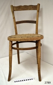
This chair has no maker's marks. The studs still on the seat, and the ventilation holes in the wooden seat, seem to indicate that the seat once had an upholstered cushion. Chair, wooden, with carved backrest and carved second horizontal back support.Seat has holes in a pattern, also studs around its perimiter. Legs and bracing ring are bentwood. Top of uprights for backrest have slight indentation design. Bemnants of dark colour stain, flagstaff hill, warrnambool, shipwrecked-coast, flagstaff-hill, flagstaff-hill-maritime-museum, maritime-museum, shipwreck-coast, flagstaff-hill-maritime-village, chair, 19th or early 20th century chair, victorian furniture, kitchen furniture, dining furniture -
 Flagstaff Hill Maritime Museum and Village
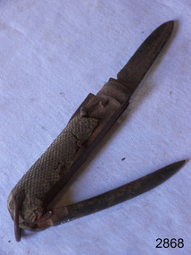
Pocket Knife
Pocket Knife, folding 2 bladed all metal with copper loop on end & spike on back. Bone handle.flagstaff hill, warrnambool, shipwrecked-coast, flagstaff-hill, flagstaff-hill-maritime-museum, maritime-museum, shipwreck-coast, flagstaff-hill-maritime-village