Showing 107 items
matching the school of dairy
-
 Canterbury History Group
Photograph - Cows (and a sheep) grazing in Canterbury, 1890, Rudd, 1890
Black and white photograph of a sheep and cows grazing near site of Camberwell High School, Prospect Hill Road, Canterbury 1890canterbury, dairy farms, sheep, cows, rudd -
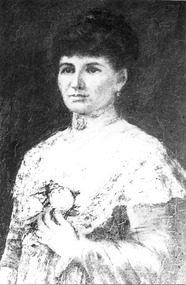 Royal District Nursing Service (now known as Bolton Clarke)
Photograph - Photograph, Portrait black and white, c.1900
This is a photograph taken from the painting by McCubbin of Lady Janet Clarke, a prominent Melbourne philanthropist who worked for social welfare issues and was a driving force in the early days of the Melbourne District Nursing Society. At the end of 1885 for her work with MDNS she was given a Testimonial Dinner where she was presented with a letter signed by 429 people expressing their thanks for her visits, kindness, sympathy and charity shown toward the sick poor. In 1887, at her home, she held the first function to raise money for the Society. Lady Janet Clarke was a generous and hospitable prominent socialite of Melbourne; a kind and sympathetic philanthropist who worked tirelessly for social welfare issues. The Melbourne District Nursing Society (MDNS) was founded on the 17th of February 1885 and on the 9th of April a Special General Meeting was held to elect the committee for the following twelve months. Lady Clarke was elected a Vice-president; a position she held until being appointed President, when Mrs. Simon resigned on the 7th of June 1887, a role Lady Clarke held until she became ill in 1908; except during her trips overseas, when the role was held by another until her return. Her management and organizational skills enabled MDNS to flourish in its earliest days. She was actively involved taking her turn on the Superintendent sub-committee where she accompanied a Trained nurse when she visited patients; checking that high quality nursing care was maintained, as well as observing the patient's social condition; even giving a personal donation to a special case in need. The patients of the Society were so grateful for her sympathy, kindness and love that when she and her husband, Sir William Clarke, were going overseas at the end of 1885, a Testimonial was given for her at Scots Church District-hall where 200 attended to show their appreciation of her work carried out with MDNS. She was presented with a Bible from them, and their letter signed by 429 working persons expressing their thanks. In a time of great financial need of the Society, Lady Clarke offered the ballroom at her home, 'Cliveden', for a monster Cake, Flower, and Dairy produce Fair which raised a substantial amount saving the Society from closure. She promoted the Society and led it in further fund-raising events, such as the annual Ball, and Fairs where she often manned cake stalls. Near Christmas each year she made a special appeal to the public for 'comfort and good cheer' which could be given to poor families visited by the Society. During the depression of 1890 she had thick soup prepared in the Cliveden kitchens and this was distributed, with bread, from her home, and from a school room, to hundreds of the poor. In 1892 Lady Clarke agreed to represent the Society during her visit to England. During her years of leadership MDNS expanded; Nurses uniforms were introduced; lectures - for example, on hygiene and on the prevention of sickness and the treatment of children, were given by doctors for the patients; further Trained nursing staff were employed; Midwifery was introduced to the poor, the Society extended beyond the city centre and bicycles were introduced for transport; a system for regular annual subscriptions was introduced and sufficient funds were raised for the Society to rent its own premises, with Lady Clarke paying for a subscription to Mullen's bookstore each year for the use of the Nurses in the Nurses Home. As well as her work for MDNS she held roles in many other organizations . She donated a substantial amount of money to build a Hostel for Women University Students attending Trinity College, later named the Janet Clarke Hall. Lady Janet Marion Clarke died at Cliveden, aged 57 years, on the 28th of April 1909; a lady held in high esteem and affection by all she knew.This is a black and white photograph of a painting of Lady Janet Clarke. She is looking forward and has a serious visage; she is wearing her long dark hair drawn up and back and in her left ear a small dropped ear ring can be seen. She is wearing a light coloured, long sleeved, floral frock with a material short cape section seen over the top of her left sleeve. Her left arm is crooked with her hand resting just under a flower brooch fastened in the centre of her frock. She has a choker around her neck with a brooch in the centre..Janet Lady Clarke, president 1889-1908.From the painting by McCubbin.melbourne district nursing society, mdns, rdns, royal district nursing service, lady janet clarke -
 University of Melbourne, School of Chemistry
Thermometer
Dairy thermometer and box, dated c 1895, used in Agricultural Chemistry -
 Melton City Libraries
Map, Streets of Melton, 1963
MELTON’S STREETS Heritage Week 2014 What’s in a Name? Alphabetical List Aboriginal place names, Early Family Names and landowners, Agricultural, Shop and Commercial premises, Places and Events Melton & District Historical Society Street Naming Project 1972 – c 1998 Suburb Name – KURUNJANG - Kirkton, 1972, Brookfield, West, 1988 Melton and Town Centre - A joint collaboration with the Shire of Melton and Subdivision Developers ARNOLD Court – Family house - Arnolds Creek ALKEMADE Drive Family – Lime kilns Coimadia ALEXANDRA Street 1902 – Corination of King Edward VII and Queen Alexandra AVIATOR Place Event, location of plane crash – Jimmy Melrose 1936 Adina ?Annibee - Anniba? Agricultural Avon court .. .. BAKERY Square - Location of Jongebloed shop, bakehouse and stables BALUK Place Aboriginal BARLEYCORN Place Agricultural BILLING Place Name of Jimmy Melrose Uncle Noel Pemberton Billing BLACKWOOD Drive - Alexander Blackwood 1860c Registrar BARRIES Road C. E. Barrie “Darlingsford” farmer 1911, chaff mill owner BROOKLYN Road Staughton family residence. 1875 – Dismantled c 193? CAHILL Drive Family - Glenville Dairy CAMERON Court Family Canopus Place ? CANALLAN Drive Early Surveyor CAMPBELL Court Aviation – Melrose passenger 6th July 1936 CARBERRY Drive Michael, early landowner family CAREW Court Edward and Michael. Royal Hotel. Vera (Carew) Forran Singer - Opera CASEY Court Family CASHIN Court Family CHEVIOT Court Agriculture, breed of sheep CHESNEY Road was re named ( Minns Road being duplicated c 1973) CHRISTINA Crescent Christina McPherson, daughter of James and Mary Mary McPherson. Died 1955 aged 85 years COLLYER Close a deleted street (parallel to Yuille) re-used CORRIEDALE Road Breed of sheep CORR Court Teacher at first school, landowner CROXTON Court Name of the Hornbuckle and Knox family home DALEY Court - William Daley and family 1865 Bootmaker High Street DARLINGSFORD Boulevard - Name of early homestead Thomas B Darling 1853 DJERRIWARRH Court - Parish County of Bourke - very early map. DODEMAIDE Place Early land owners - Melton Football Team had 6 brothers playing c 1924 DONALD Court McPherson family 6 generations in Melton in 1936 DOUGAL Court DUNCAN Court .. .. DUNVEGAN Circuit Home of the McPherson family, castle Isle of Skye Name of bluestone house Smith Street (now at Willows) EMIL Court Jongebloed family EXELL Avenue Farming family Melton Sth- Closer Settlement 1907 EXFORD Road Exe former name of the Werribee river FARMER Court Name of early postmistress FERRIS Road John Ferris Farmer HANNAH Close First name of Hannah Watts – midwife HAYBALE Place Agricultural HELDER Court Early surveyor J Helder Wedge map HEWSON Street Winston Hewson Shire Engineer – check title c 1960 HENRY Street Township map c 1860 HESTON Street Heston Phoenix – C.J. Melrose plane HILDEGARDE Court Jimmy Melrose’s mothers name HOMESTEAD Close HORNBUCKLE Cres Farmers. Three members of family - Shire Presidents HURLEY Street Farmers IAIN Court Descendent of James and Mary McPherson JAMES MELROSE Drive Name appears on 2013 Melton information map JANG Place KURUN – jang KIRKTON Drive Name of the McPherson family home Toolern Vale Road KIRWIN Street Michael early landowners (deleted for freeway construction) KILPATRICKS Road Deleted when Barries Road was extended across Station Rd KOROROIT Court Early map, Parish of Kororoit. Creek name KNOX Circuit Family – Hornbuckle “Croxton Park” KURRUNJANG Drive Aboriginal name for people of the red earth – Suburb name Lara Place ? LLOYD Court Garage owners High Street. Laura lived to 100 years D 1955 LUBY Court John Luby – Crown Grant Land Title LITTLE Court MANNING Avenue Richard, hotel owner 1891 MARGARET Drive McPherson family McDONALD Street Melton South family name McKENZIE Street Township c1860 MORROW Street Early name MOWBRAY Crescent Name of English Melton, popularly believed origin of Melton MYERS Court Early setters c 1866 Crown Grant Land Title NIMMO Street Early name NIXON Street Name submitted by Mary nee Nixon Collins c1985 OLDERSHAW Road Early builder PALMERSTON Street Early township map c 1860 PEART Court Early name PENNYROYAL Avenue Plant growing by the creek. Early name used for the Toolern Toolam Creek PINKERTON Street Family name and early street map PINNACLE Crescent Agricultural - type of wheat PHOENIX Circuit C.J. Melrose Phoenix Heston Plane 2013 map PRATT Family PRIOR Court PYKE Place Brothers – early settlement 1838 RADFORD Court Land owners and business operators. Former Royal Hotel Grocer High Street demolished 1970 RAGLAN Court Hotel 19th century Lord Raglan RALEIGHS Road Oliver Reierson family (Norweigen) Shopkeeper – Dressmakers RIDDELL Drive (misspelt Riddle) Resident and land owner RODERICK Road McPherson family – a re occurring name ROLLAND Court Jones family ROSS Court Daniel. Landowner. Agnes Ross music teacher RUSSELL Court Robert. Early land surveyor of Melton 1853 RYAN Court Family early landowner. Member of the 1862 Road Board SHEBLER Place Augustus early Melton resident – Golden Fleece Hotel SHEEPFOLD Court Farming SHERWIN Court Sherwin Street earliest Township map– became Golf course SMITH Street Early township map. STRATHULLOH Circuit Strathtulloh Homestead. STAUGHTON Street Family – LARGE land owners Strachan ? SWANEY Court Marie Swaney earlier resident of Strathtulloh. SUTHERLAND Family name TOOLERN Street TOOLAM – TOOLERN Creek TULLIDGE St Road marked on 1861 map UNITT Street Early Township c 1860 WALLACE Square Cr Jack Wallace 5 terms as President 46 years unopposed WATTS Court Hannah Watts – midwife, cottage hospital WALSINGHAM Name of house of Minns family. From Walsingham Norfolk England WESTLEY Place Name of Jimmy Melrose Percival Gull Plane WESTLAKE Drive Early resident WHICKHAM Street Family Name Melton South WILSON Road Albert, Melton South YUILLE Street William Cross, early landowner, Rockbank run Zoomed in section of Melton Streets including Church and High Streetlandscapes of significance -
Canterbury History Group
Ephemera - touchstones to WW1 in Balwyn, Camberwell, Canterbury and Surrey Hills, Susan Barnett, 1/04/2015 12:00:00 AM
Booklet compiled by Susan Barnett, President of the Surrey Hills Historical Society with the assistance of the Balwyn Historical Society, Camberwell Historical Society, Canterbury History Group and the Surrey Hills Historical Society, for a bus tour of significant places in Boroondara to commerate the centenary of the Gallipoli Landing.beckett park memorial, white> dorothy sevilla, cahill> francis matthew, cahill> martin, cahill> richard nicholas, cahill> kevin martin, lone pine dairy - balwyn, bignell> alfred charles, canterbury citizens carnival, canterbury gardens, soldiers - memorial hall - canterbury, canterbury memorial home units, canterbury primary school, camberwell city rsl sub-branch, golding> herbert, daly> gustav anthony disney, daly> william constant beck, daly> clarence wells didier, wattle park lone pine, clock tower memorial> wattle park, hethersett house - plc - burwood, surrey gardens - memorial cross, surrey gardens - the shrine, steele> mrs charles h d, blogg> john kendrick, gawler> john stephens, mawson> frederick w, webster> clarence -
Lakes Entrance Historical Society
Book, Gippsland Heritage Journal No 11, 1991
Issue 11 of a series of Journals showcasing Gippsland history contains articles on Limestone Creek, Crooked River School, Inverloch, Port Albert, Wattle Bark Industry and dairy farming personalities sister Ellen Mc Carthy, Amos Brazier, John Lardner, Tomsettlers, schools, agriculture, industrial -
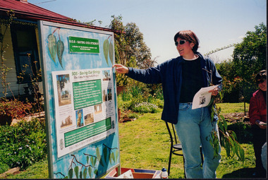 Wooragee Landcare Group
Photograph, 5 September 2004
Wooragee Landcare Group took a bus trip Sunday 5th September to Samaria, Tatong area (near Benalla) to look at land use on small farms. Around this time, Wooragee Landcare were looking into how small land holders could run some enterprises. This photo was taken at Tatong Tavern where the group had lunch. The Tatong Tavern is an old English style pub situated in the foothills of the Great Dividing Range the small community of Tatong 23km south-east of Benalla. The original weatherboard hotel was originally built in the 1880s by William Worrall who was listed as Hotel Keeper from 1886 to 1910. It was destroyed by fire in 1923 and replaced by the current building, which has undergone many changes over the past 100 years. The name has also changed from the Tatong Hotel or ‘Pub’ to the current name of Tatong Tavern.Tatong is a rural village in north-east Victoria, set in undulating country that rises southwards to the Tolmie ranges. The name is thought to derive from an Aboriginal expression, possibly referring to something unseen. The Tatong pastoral run was taken up in 1847 and farm selections began in the 1870s. A school opened in 1890 (closed in 2006). Dairy herds were grazed on the Tatong flats and a cooperative creamery operated from 1892 until 1918. In 1914 a branch railway line was opened from Benalla to Tatong that carried farm produce and timber to Tatong, which had two sawmills in the 1920s. There was also a general store, a police station, and a livestock trucking yard. St Albans Church of England was built in 1921. Most of those buildings have now disappeared. The Tatong Tavern along with the Hall built in 1904 are the only remaining buildings. The Tatong Tavern is a significant tangible and visual representation of the area’s cultural and social history over the past 100 years. Coloured rectangular photograph printed on paperReverse: WAN NA E0NA2N2. NNN- 14240/ (No. 20) 373/ tatong, tatong pub, tatong tavern, tolmie ranges, tatong flats, benalla, wooragee landcare, wooragee landcare group, bus trip, samaria, land use, william worrall, 1800s, 2004, mount samaria -
 Eltham District Historical Society Inc
Photograph - Digital Photograph, Alan King, Memorial to Peter Brock, Ferguson's Paddock, Hurstbridge, 23 January 2008
Ferguson’s Paddock, Hurstbridge. A plaque on a boulder commemorates Peter Brock. Published: Nillumbik Now and Then / Marguerite Marshall 2008; photographs Alan King with Marguerite Marshall.; p167 On a rock in Ferguson’s Paddock, Hurstbridge, a plaque commemorates Peter Brock. It includes the words: ‘Boy from Hurstbridge without special privileges, grew to become champion of racetracks around the world but he never forgot his beginnings’. Brock came from a well-established local family. Born in Hurstbridge in 1945, he lived in Anzac Avenue as a child, attended the Hurstbridge Primary and Eltham High Schools and lived in the district most of his life. His father Geoff owned the Diamond Valley Speed Shop in Greensborough. Brock’s forbears were amongst the area’s earliest settlers. From Scotland, the Brocks arrived in Tasmania in 1830, to graze sheep. Family members moved to Sunbury, then Preston, grazing sheep in the Bundoora area. John Brock owned Janefield, possibly named after his wife. In 1855 he granted around two acres (0.8ha) of his estate for a school.1 In 1866 Lewis Brock bought 264 acres (107ha) in Nutfield, the first non-Aboriginal person to own that land. They planted an orchard, then from around 1935, Brock’s uncle Sandy and his grandfather Lewis, ran a dairy on the property. In the 1980s Brock and his then partner Bev, bought most of the property, which they sold after their separation in 2006. Brock’s father was a Hurstbridge Football Club President, but Brock’s uncle Sandy, of Brocks Road, Doreen, has been particularly active in local affairs. He was President of the Mernda Football Club (then Plenty Rovers), President of the Panton Hill Football League and he founded the Arthurs Creek and District Landcare Group. He also gave more than 50 years of service to the Whittlesea Agricultural Society, the Volunteers for Australian Football and the Doreen Rural Fire Brigade. Community service was important to Brock too. Brock, with his then partner Bev, established the Peter Brock Foundation in 1997, the year he retired from full-time V8 Supercar racing. The Foundation’s grants have included $100,000 towards the upgrade of a walking track in the Hurstbridge Parklands and other projects include a holiday house for the families of child cancer victims. Brother Lewis saw Brock as a spiritual person, who had a great affinity with people. He saw Brock as a role model of someone who could achieve their dreams. ‘The family didn’t have much money, yet that didn’t stop Peter realising his dreams. He was strong and didn’t let difficult times crush him.’ Despite his later successes, Brock’s most treasured trophy was for running 100 yards (91.4m)at his primary school in 1955, and he appreciated his head master Ted Griffiths’ encouragement of his sporting endeavours. At high school Brock became captain of Everard House. In his first year he bought a 1928 Austin 7 for £5. He cut the car into a box shape with an axe and enjoyed driving it – despite it having no brakes - at his grandparents’ farm at Nutfield. The turning point in Brock’s life came at age 23, when he built an Austin A30 in an old henhouse in Wattle Glen, using a Holden engine. He was laughed at until it won the Australian Sports Sedan Championship in 1968. Brock’s career then took off and he became a professional driver. Brock won Australian motor sport’s best-known event, the Bathurst 1000, nine times. Brock endured a bitter split from Holden in 1986 over control of his Holden-backed vehicle modification business and a car performance-enhancing device he called the ‘energy polariser’– despite it having no scientific evidence to support its claims. But Brock returned to Holden in 1994. Then in 1997, aged 52, Brock retired from fulltime V8 Supercar racing. However he continued to race at motor sport events. Brock won several awards, including an Order of Australia Medal in 1980, the Australian Sports Medal in 2000, and the Centenary Medal. On September 8, 2006, Brock died; after his car hit a tree during the Targa West Rally in Western Australia.This collection of almost 130 photos about places and people within the Shire of Nillumbik, an urban and rural municipality in Melbourne's north, contributes to an understanding of the history of the Shire. Published in 2008 immediately prior to the Black Saturday bushfires of February 7, 2009, it documents sites that were impacted, and in some cases destroyed by the fires. It includes photographs taken especially for the publication, creating a unique time capsule representing the Shire in the early 21st century. It remains the most recent comprehenesive publication devoted to the Shire's history connecting local residents to the past. nillumbik now and then (marshall-king) collection, ferguson's paddock, hurstbridge, peter brock memorial, peter brock -
 Eltham District Historical Society Inc
Photograph - Digital Photograph, Marguerite Marshall, Wingrove Cottage, Main Road, Eltham, 8 June 2006
Wingrove Cottage built 1858-1859 of hand made bricks is historically significant for its long association with Charles Wingrove, a prominent figure in Victorian local government, as secretary to the Eltham District Road Board and Shire Council from 1858 to 1904, and Shire Engineer and Secretary to the Heidelberg Road Board. The cottage was used as the office of the Eltham District Road Board and Council for many years It is one of the Shire's oldest dwellings, and one of the few surviving 19th century buildings associated with early Eltham and located in the original Eltham Village Reserve. The symmetrical planting of a pair of Pencil Pines (not visible in photo) is also historically and aesthetically significant as characteristic of the early period of planting in the district and because they are a distinctive landscape feature. In October 2002 new owners demolished the outbuildings attached to the rear of the cottage. Community protest at the demolition resulted in Council issuing a Stop Work order. The owner was issued with a court order in September 2003 to develop a conservation management plan and restore the heritage listed property. The owner sold the property in 2005 to Cameron Construction in 2005 who undertook the restoration work. In 2007 a planning application to build two offices and seven dwellings at the rear of the property was ultimately rejected. The cottage is now the main office for Cameron Construction. Covered under Heritage Overlay, Nillumbik Planning Scheme. Published: Nillumbik Now and Then / Marguerite Marshall 2008; photographs Alan King with Marguerite Marshall.; p57 Wingrove Cottage on Main Road beside Eltham Primary School, is one of the Shire’s most important historical buildings and was central to local government for almost 50 years. The cottage was built in stages from 1858 to 1888 for Charles Symons Wingrove JP. He was the Eltham District Road Board’s first paid secretary and later the Shire Secretary when the board became the Eltham Shire Council. Wingrove held those positions, and that of engineer for a time, for 46 years. He was also one of the main figures in the Municipal Association of Victoria. As Eltham’s first paid municipal officer, Wingrove used one room in his 11 – (originally two) roomed home, as the office for the board then the council. Meetings were held there from the late 1850s (as well as at more central locations) until Wingrove’s retirement in 1904. The cottage is a rare example of a local government office occupying a Road Board /Shire Secretary’s purpose-designed house. The cottage is also significant because it is the oldest largely intact building from the original Eltham township reserve (south of Dalton Street).1 The township had its origins in the 1848 Nillumbik Parish Plan and was one of the state’s earliest township reserves. The rectangular house of handmade bricks, roofed with grey slate tiles and with a veranda encompassing three sides, is reminiscent of those in the central goldfields including Castlemaine. Its overhanging eaves and gables were unlike houses in Melbourne at the time. Wingrove, who was born in 1827, had been a gold digger and a road surveyor. Impossible to imagine in today’s world, Wingrove was also the Shire of Heidelberg’s secretary and engineer for part of the time that he was secretary in Eltham. Living next door to the primary school was a mixed blessing. Wingrove and his wife Katherine, who had ten children, sent their eight surviving children to the school. But they had occasional disputes with the school authorities when their cattle wandered into the schoolyard. Eltham showed Charles Wingrove its appreciation of his services by giving him two illuminated addresses, one after ten years and the other at retirement. Wingrove died in 1905 aged 76 and was buried in the St Katherine’s Church of England cemetery in St Helena. His grave is surrounded by those of family members including his wife, Katherine and two babies, Henry, 12 months and Isobella, 15 months, who died in the mid-1860s. Cottage ownership passed to his wife, then to daughter Caroline and then to daughter Bessie, a Melbourne University graduate and artist. During the Great Depression their brother Walter was the ratepayer. At one stage the Wingrove property extended to Metery Road and included a small creek. The family ran a small dairy and orchard, with associated farm buildings, which were later removed. In 1949 part of the property was compulsorily acquired by the Eltham Primary School, which infuriated owner Bessie Wingrove. She protested in a letter about this ‘monstrous act of unmitigated tyranny’.2 She was the last Wingrove to occupy the cottage and died in 1955. Wingrove descendants sold the house in 1974 and the property was subdivided. In the 1960s the Eltham Shire named the park opposite the cottage in Wingrove’s honour. The cottage has since had several owners including psychiatrist Dr Daniel Kahans, who practised there. In October 2002 late rear additions which had been substantially altered were demolished contrary to council planning controls. This caused a community outcry and resulted in legal proceedings against the owner. Fortunately the historical significance of the demolished section was not as great as the older front part of the building, which has been retained and was later restored.This collection of almost 130 photos about places and people within the Shire of Nillumbik, an urban and rural municipality in Melbourne's north, contributes to an understanding of the history of the Shire. Published in 2008 immediately prior to the Black Saturday bushfires of February 7, 2009, it documents sites that were impacted, and in some cases destroyed by the fires. It includes photographs taken especially for the publication, creating a unique time capsule representing the Shire in the early 21st century. It remains the most recent comprehenesive publication devoted to the Shire's history connecting local residents to the past. nillumbik now and then (marshall-king) collection, cameron construction, charles symons wingrove, eltham, eltham road district board, eltham shire council, main road, wingrove cottage -
 Eltham District Historical Society Inc
Photograph - Digital Photograph, Alan King, Ellis Cottage, Diamond Creek, 23 January 2008
Built by William Ellis in 1865 of local uncut stone about 30cm thick, the cottage is now a museum and home to the Nillumbik Historical Society. Ellis Cottage is historically significant for its association with the Ellis family, who were pioneers of the Diamond Creek district and the benefactors of the notable Nillumbik Cemetery gateway. It illustrates the development of farming in the area. Ellis Cottage is historically and technically significant for its rare use of uncut local stone for building purposes. Covered under Heritage Overlay, Nillumbik Planning Scheme. National Estate Published: Nillumbik Now and Then / Marguerite Marshall 2008; photographs Alan King with Marguerite Marshall.; p79 Ellis Cottage, built by William Ellis, is a memorial to the courage of pioneers in the Diamond Valley area.1 Now a museum and home to the Nillumbik Historical Society, it is a fine example of an early settler’s house in Diamond Creek – and one of the few original buildings standing from the middle of the 19th century. It is a poor man’s cottage – typical of the dwellings of those who had to work hard to wrest a living in this district, because most of the land was not fertile enough for major forms of farming. The pretty stone cottage at 10 Nillumbik Square, built in 1865, is made of local uncut stone about one foot (30 cm) thick. It once stood near the centre of the 147 acres (59.4ha) Ellis bought in 1850. The property extended from Diamond Creek to Reynolds Road and from Perversi Avenue to the Wattle Glen School. It stood in the electoral parish of Nillumbik. The Nillumbik township (later called Diamond Creek) was not created until 1867. In 1912 the property was cut in half by the new railway to Hurstbridge. Ellis paid £147/10/- for the land - about three times what a Victorian farmer would usually earn in a year. Despite the poor quality soil Ellis became a very successful farmer with an orchard, vegetables and a dairy herd. Five years later, in 1855, Ellis bought 70 acres (28.3ha) from neighbour, Hugh Larimour. In 1857 Ellis bought 208 acres (84ha) at Yarra Glen. In 1877 he bought 122 acres (49.3ha) at Diamond Creek and later bought land at Greensborough and Woodstock. Ellis was born in 1815 at Blackawton, a small Devonshire village, and became a tenant farmer. It is not known why Ellis came out to Australia or settled in Diamond Creek. In 1847 he married Margaret Child at the Melbourne Presbyterian Church. Ellis and Child had no children and 18 years after the wedding, while probably living in Kangaroo Ground, Ellis built this small cottage. The simple cottage has a central hall and two rooms on each side. To maximise the small space the ceiling cavity was designed large enough to provide sleeping accommodation accessed via a ladder. Each room was heated by an open fireplace and the one in the kitchen was large enough to roast a sheep. A large cellar under the front room probably stored farm produce. Water came from a well as reticulated water did not arrive at Diamond Creek until 1914. In 1870 Ellis’ 22 year-old nephew Nathaniel joined him from England.2 Until 1890 they developed Ellis Park, praised in The Evelyn Observer, May 30,1890 as a model farm. Ellis had become wealthy, and on his death in 1896 his estate was valued at £9000. In his will he left £100 to construct memorial gates at the Nillumbik Cemetery where he was buried.3 Ellis left the farm to his second wife Louisa. As he had no children, upon her death the farm passed to Nathaniel, but he did not take it up. The farm was sold and leased several times until 1967, when engineer Phillip Lovitt bought the property and carried out major structural works. The Shire of Diamond Valley bought it in the 1980s and in 1989 restored it with the Nillumbik Historical Society. The stone walls of the cottage had been plastered with mud and straw mortar, which were removed as they were riddled with vermin. Doors, windows and a floor were replaced and the original roof of timber shingles had been replaced with slate. The well was too deeply cracked to be restored, so was used for a flower bed. Two mature Italian Cypresses at the entry are also heritage protected as they relate to similar trees planted at Shillinglaw Cottage and other early buildings in Nillumbik Shire.This collection of almost 130 photos about places and people within the Shire of Nillumbik, an urban and rural municipality in Melbourne's north, contributes to an understanding of the history of the Shire. Published in 2008 immediately prior to the Black Saturday bushfires of February 7, 2009, it documents sites that were impacted, and in some cases destroyed by the fires. It includes photographs taken especially for the publication, creating a unique time capsule representing the Shire in the early 21st century. It remains the most recent comprehenesive publication devoted to the Shire's history connecting local residents to the past. nillumbik now and then (marshall-king) collection, ellis cottage, diamond creek, nillumbik historical society, william ellis -
 Eltham District Historical Society Inc
Photograph - Digital Photograph, Marguerite Marshall, Strathewen Public Hall, 20 August 2008
Strathewen Public Hall, social and spiritual centre was later lost in the Black Saturday fires 2009. The Strathewen Community decided a community hall was needed in 1901. In 1902 locals built the hall with messmate trees. It was located on the Cottlesbridge-Strathewen Road. The first function was a Grand concert and Balll attended by about 120 people. Several denominations held Church services and Sunday School services in the Hall. It survived several bushfires until after this photo was taken when it was destroyed in Black Saturday, 9 February 2009. Published: Nillumbik Now and Then / Marguerite Marshall 2008; photographs Alan King with Marguerite Marshall.; p89 Strathewen was settled late, largely because it was difficult to access.1 Early selectors found it a struggle to survive. They had to do everything themselves, from felling trees for buildings, to taking produce to market along bush tracks that they had helped cut. Small dairy farms were typical but fruit became the district’s prime produce. The first settlers east of Arthurs Creek were brothers John and Duncan Smith whose station Glen-Ard was probably operated as a sheep run. Other early settlers were the Mann family, who were to donate land for the hall, provide postal services and John Mann was an Eltham Shire councillor from 1916 to 1919.2 In 1873 James Mann, his wife Jane and their six children, settled on 207 acres (83.7) (Lang Fauld Farm) on both sides of Eagles Nest Road, from the foot of Mount Sugarloaf to the bank of the Arthurs Creek. In 1883 James took up another selection on Chads Creek. It was very hard work and at times he was well behind with his rent. However the family had a good social life, attending the Primitive Methodist Church at the Arthurs Creek Township and on New Year’s Eve throwing a party for all the locals. By 1874 James Mann’s younger brother, John, selected 311 acres (125.8ha) between Eagles Nest Road and upper Arthurs Creek. He called it Carseburn after his home parish in Scotland. Tragically in 1875 John drowned in the Yarra River, at Richmond.3 John Mann’s oldest son, also John, later purchased Duncan Smith’s land, which he named Violet Glen. He was to give one acre (0.4ha) of this land for the Strathewen Hall site. A Mann family diary written at Carseburn in 1897, tells how the district’s name was selected. Strathewen is derived from ‘strath’ meaning ‘broad mountain valley’ and from the name of Ewen H. Cameron, the local parliamentarian for almost 40 years. ‘George Brain came around to get a petition signed to get a post office up here and we had to vote for a name—Strathewen, Glen-Ard, or Headcorie’.4 It was at Carseburn that a public meeting in 1901, decided to build the Strathewen Hall on the Cottlesbridge-Strathewen Road. In 1902 the locals built the hall with messmate trees. The first function was a Grand Concert and Ball attended by around 120 people and several Protestant denominations took turns to hold church services and Sunday School there. Fortunately the hall has survived bushfires to be the town’s spiritual and social centre.5 The area continued to develop and in 1909 a post office operated somewhere at Strathewen and from around 1916 at Carseburn.6 It was not until 1914 that land was bought to establish the Strathewen State School on School Ridge Road. The residents paid £100 to build it on two acres (0.8 ha) while the Education Department contributed £30 and leased the building annually for £1. When teacher Miss Mary Golding opened the school in 1917, it had no equipment.7 But in 1921 the Education Department provided desks and a hexagonal shelter shed (now a rare style in Victoria) and took control in 1925.8 By 1917 Strathewen was booming.9 George Apted had built a coolstore in 1916, and local orchardists bought storage space until the 1950s. This allowed the area to supply the market in and out of season. Guesthouses catered for growing tourism. In the mid 1920s Mrs Eleanor Sparkes built the guest-house Singing Waters, which operated through the 1930s. Her daughter Mrs Vera McKimmie, ran it until the 1950s and the house remains in Chads Creek Road. In the Great Depression land was cleared for timber to be sold as firewood and there was small scale sawmilling. However the orchard industry diminished for several reasons including the 1939 bushfires and rapid changes in production methods. Today the Apteds still operate an orchard and farm at Glen-Ard, which straddles the border between Strathewen and Arthurs Creek. It includes the southern part of Duncan Smith’s original Glen-Ard selection.This collection of almost 130 photos about places and people within the Shire of Nillumbik, an urban and rural municipality in Melbourne's north, contributes to an understanding of the history of the Shire. Published in 2008 immediately prior to the Black Saturday bushfires of February 7, 2009, it documents sites that were impacted, and in some cases destroyed by the fires. It includes photographs taken especially for the publication, creating a unique time capsule representing the Shire in the early 21st century. It remains the most recent comprehenesive publication devoted to the Shire's history connecting local residents to the past. nillumbik now and then (marshall-king) collection, strathewan public hall -
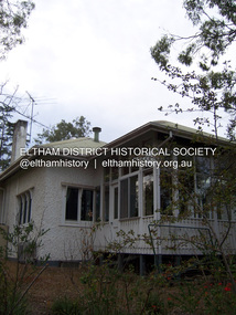 Eltham District Historical Society Inc
Photograph - Digital Photograph, Alan King, Stanhope, Peter Street, Eltham, 15 March 2008
On the crest of Stanhope Hill at Peter Street, Eltham, stands the former home of a couple, Clem and Nina Christensen who had a major influence on the literary development of post World War 2 Australia. Covered under Heritage Overlay, Nillumbik Planning Scheme. Published: Nillumbik Now and Then / Marguerite Marshall 2008; photographs Alan King with Marguerite Marshall.; p109 On the crest of Stanhope Hill at Peter Street, Eltham, stands the former home of a couple, who had a major influence on the literary development of post World War Two Australia. In 1946, Clem and Nina Christensen bought the house, which had been designed by Harold Desbrowe Annear, considered to be one of Australia’s most innovative architects in the first quarter of the 20th century.1 That year the stucco building with a metal roof, built in 1910, was extended to the north and south. The main residence was built of jarrah, with stucco walls, floors of Tasmanian hardwood and rooms panelled with Californian redwood (sequoia). The property included a cottage, former stables, a dairy and meat-house. From its beginnings the property has attracted artists and intellectuals. Official World War One artist, Will Longstaff, bought the property – then 15½ acres (6ha) around 1900. Famous for his painting The Ghosts of Menin Gate, now in the Australian War Memorial Canberra, Longstaff was the cousin of another well-known painter, Sir John Longstaff. Several leading artists visited Longstaff at Stanhope including Walter Withers of the Heidelberg School, who lived in Brougham Street, Eltham. In 1919, Theo Handfield, father of author and journalist John Handfield, bought the property from Mrs Longstaff. Then in 1924 the land was subdivided and most of the estate (80 blocks) was auctioned. The next owner was related to novelist Virginia Woolf. Bishop Reginald Stephen, Warden of Trinity College, bought the house and five acres (2 ha) in 1928. He was related to Sir Leslie Stephen, the first editor of the Dictionary of National Biography and Woolf’s father. Novelist and music critic John Harcourt, was the next tenant, while he and his wife Fay, built their mud-brick house Clay Nuneham, at the foot of Stanhope Hill. Dr Clem and Mrs Nina Christensen, lived in the house until their deaths. Clem Christensen – who died aged 91 in 2003 – was a poet, short story writer and painter. However, he is most noted for founding Australia’s foremost literary journal2 Meanjin (originally Meanjin Papers), which he described as ‘democratic left of centre’, in Brisbane in 1940. Clem brought Meanjin to Melbourne in 1945 and remained editor until 1975. Enormously influential, Meanjin spawned and encouraged many of Australia’s best literary talents and it had an international reputation. Meanjin was the first to publish such writers as Judith Wright and David Malouf and it encouraged writers like Patrick White and Peter Carey. Nina Christensen – who died aged 89 in 2001 – was founding Editor of the Melbourne Slavonic Studies Journal and pioneered the study of Russian in Australia. In 1946 she established the Department of Russian Language and Literature at The University of Melbourne, which she led until 1977. Nina’s graduates largely staffed subsequent departments, in other Australian universities.3 However Nina’s Russian heritage and Clem’s outspoken views caused problems. They were forced to defend themselves in the Petrov inspired Royal Commission on Espionage in the 1950s, but were exonerated. The Christensens attracted and hosted many distinguished Australian and foreign writers, artists and academics, including Nobel prize-winning novelist, Patrick White and the world’s then leading cellist, Mstislav Rostropovich.4 Other writers and intellectuals who visited Stanhope were: Vance Palmer, Alan Marshall, A D Hope, Xavier Herbert, Nevil Shute, Geoffrey Dutton, Martin Boyd, Judah Waten, Bruce Grant, Dorothy Hewett and Sir Herbert Read. Painters included: Danila Vassilieff, Arthur Boyd, Albert Tucker, Justus Jörgensen, Robert Hughes and Clifton Pugh. Academics included: Manning Clark, Geoffrey Blainey, W Macmahon Ball, Richard Downing, Geoffrey Serle and scientist Tim Marshall. Politicians included: Jim Cairns, Pauline Toner, Lance Barnard, Sir Paul Hasluck, Sheryl Garbutt and performance artists included: film star Olivia Newton-John, members of the Bolshoi ballet and the Russian State Ballet of Siberia.5 Nina Christensen was honoured in 2006 at the Eltham Living and Learning Centre with the building of an amphitheatre designed by V Sverdlin.This collection of almost 130 photos about places and people within the Shire of Nillumbik, an urban and rural municipality in Melbourne's north, contributes to an understanding of the history of the Shire. Published in 2008 immediately prior to the Black Saturday bushfires of February 7, 2009, it documents sites that were impacted, and in some cases destroyed by the fires. It includes photographs taken especially for the publication, creating a unique time capsule representing the Shire in the early 21st century. It remains the most recent comprehenesive publication devoted to the Shire's history connecting local residents to the past. nillumbik now and then (marshall-king) collection, clem christesen, eltham, nina christesen, peter street, stanhope -
Merbein District Historical Society
Journal - Quarterly, Merbein Historian - Quarterly Journal of MDHS - No 43 (2 copies), Mar.2011
mark (cr) eckel., bernadette wells, a self drive tour of historic sites - buildings - places of interest, hazel dowsley, merbein higher elementary school staff 1958, mavis mary bennett, jack bennett, ray slade, joan (nee goetz) dodds, easter camp memories 1952 - 1956, shirley lake (racquets), merbein dairy, dora's diaries, joyce bosenberg (letter) , merbein cheer up club, barbara downing, richard neeman, dorothy nice, laurel nice, vi nice, phillip day, arthur mcmahon, douglas hore, richard appleby, percy appleby, appleby vintage equipment, samuel brindsen, jack treen, albert hunt, elwood mead, merbein common -
Canterbury History Group
Document - Thematic Environmental History, Built Heritage, 1/05/2012
Thematic Environmental Heritage. Final document produced, after community consultation, for the City of Boroondara by Built Heritage242 pages city of boroondara, back yards, canterbury, churches, cottages, dairies, danks family, elgar survey, exploration, frognall, goldings boot factory, maling road, malone's hotel, maps, masonic lodges, national parks, native plants, outer circle railway line, police stations, post offices, railways, rochester road, schools, shrublands, soldiers memorial hall, sport, telephone exchanges, theatres, transport, wildlife, canterbury road, land subdivisions, parks and reserves -
 Melbourne Tram Museum
Photograph - Digital Image, Kevin O'Reilly, "Kew Burke Rd' looking at the East Kew Tram terminus, c1925
Image from CD (Compact Diskette for use in computers) - see Reg Item 135. Image titled "Kew Burke Rd' on CD, of looking at the East Kew Tram terminus with the city skyline in the background, c1925. Photo published in the Bellcord No. 16, Oct. 2012. From the article with the photograph; The terminus was located at the intersection of High St, Burke, Kilby and Doncaster Roads. We are at the outer edges of Melbourne’s suburbia at the time, unlike the current tram terminus of today. Burke Road, north of Doncaster Road is clearly under construction in preparation for the new river crossing. The vacant block of land in the foreground will remain so for another ten years or so. In 1960 the new Dickens Supermarket was built on this site and the intersection became known locally as Dickens Corner. The narrow track on the left hand side of the photo is Doncaster Road. The tram at the terminus is a straight-sill single trucker of one of the G, K, Q or R classes. It is finished in the late MMTB chocolate and cream livery. A cable grip car body has been placed as a tram shelter at the terminus. The church was subsequently relocated to Francis Street Yarraville where it still stands today as a private residence. Behind the large hedge on the south side of High Street is Smith’s Dairy. Part of this land would be sold to the MMTB for a planned new tram depot Behind the large hedge on the south side of High Street is Smith’s Dairy. Part of this land would be sold to the MMTB for a planned new tram depot but by the early 1960s it was transferred to the Education Department for construction of the Kew High School. The last portion of the dairy closed in the 1970s.trams, tramways, kew, burke rd, east kew, doncaster rd -
 City of Moorabbin Historical Society (Operating the Box Cottage Museum)
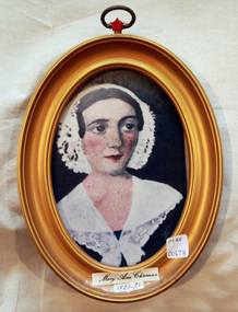
Print - Mary Ann Charman 1820 - 1870
Mary Ann Charman was a pioneer settler in the Cheltenham area of the Parish of Moorabbin c1850 Stephen Charman , who emigrated in 1942 as a Henry Dendy employee aged 21 years, sadly lost his wife and child shortly after arriving in Brighton. When Dendy could not employ him he found other work. In 1850 he met Mary Gettens a widow with 5 children who supported her family by managing her late husband’s Inn in Collins St. Melbourne. Stephen purchased land in Spring Grove, now Cheltenham, in 1852 and the family moved to the wattle and daub hut after their marriage. Mary and Stephen worked very hard to establish a market garden, poultry and pork farm . They specialised in Marigolds which they sold to Martin & Pleasance Pharmacy , Melbourne for medicinal purposes. Mary and Stephen had 7 more children and Mary still managed to find time to sell the pork, poultry and vegetables from a horse drawn cart she drove around St Kilda. 1857 Stephen donated land to the Methodist Church for a School, burial ground and Chapel in Balcombe Road. Mary died 1870. Stephen remarried in 1878 and died aged 85 years 1906. Charman Road runs from Nepean Highway , Cheltenham through Beaumaris to the Beach Road at Mentone. Mr Les Jones was the Great Grandson of Mary Ann CharmanAn oval framed colour copy of a painting of the likeness of Mary Ann Charman, 1820 - 1870 pioneer settler in the Cheltenham area of the Parish of Moorabbinpioneers, early settlers, dendy henry, charman mary ann, jones les, cheltenham, moorabbin, brighton, market gardeners, dairy farmers, charman road -
City of Moorabbin Historical Society (Operating the Box Cottage Museum)
Newsletter - CMHS February 2014 pdf, February 2014
The City of Moorabbin Historical Society was formed c 1960 by a group of Moorabbin area residents who were concerned that the history of the area should be preserved. A good response to a call for items related to the historical area of Moorabbin Shire brought donations of a wide variety of artefacts that are now preserved by the current members of CMHS at Box Cottage Museum. Helen Stanley, Secretary of CMHS, began producing a Newsletter for members in April 2007 to provide current information and well researched items of historical interest. Jim Dale continued to produce the Newsletter in 2013 after Helen resigned.5 x A4 paper pages printed on one side with colour photograph, Jim Dale, President, welcomes members to the February 23rd Meeting at Box Cottage and acknowledges Anne Caprackas as Secretary and Dr Bill Richardson is now Treasurer. Jim will have a Stall at the Moorabbin Primary School Fete in March. Jim went to a meeting to discus plans for 2015 Commemoration of the Great War in Glen Eira. Members Bill, David, Daryl Carol, Joan collected and installed a large Display Cabinet in the Dairy on December 19th and Dennis fitted castors to it in January. Jim was present on February 3rd when members of the Harry Hawker family presented a memento to the Victorian Governor, His Excellency Alex Churnov The next Meeting will be March 30th Jim Dale attached the Final Part of his report 'The Allynson's of East Bentleigh' about 'The Petrov Affair 1954'City of Moorabbin Historical Society Newsletter February 2014ity of moorabbin historical society, stanley helen, dale jim, melbourne, moorabbin, brighton, cheltenham, ormond, bentleigh, market gardeners, pioneers, early settlers, east bentleigh, city of kingston, vladimir mickalovick petrov, evodika petrov, michael thwaites, maria allynson, sven allynson, kgb, mvd, asio, ‘petrov affair’, darwin airport, mascot airport, col. charles spry, cold war 1950