Showing 269 items matching "valley lake"
-
 Marysville & District Historical Society
Photograph (Item) - Colour photograph, Unknown
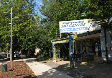
A colour photograph of the Marysville Ski Centre in Victoria.A colour photograph of the Marysville Ski Centre in Victoria. Marysville Ski Centre is a family-owned business, which has been operated by Nat and Beryl Morandi since 1981. The business started from very humble beginnings hiring toboggans at Lake Mountain initially from the back of a Bedford Van, and then upgraded to a rickety old shed with the addition of ski equipment for hire. In 1983, Marysville Ski Centre commenced business in its current position in Marysville. Then this building was destroyed, along with most of the buildings in Marysville, during the 2009 Black Saturday bushfires. Currently, the business operates from their new custom-designed ski hire which has been built to cater for the different needs of the hire.marysville, victoria, marysville ski centre, photograph, nat morandi, beryl morandi, 2009 black saturday bushfires -
 Marysville & District Historical Society
Ephemera (Item) - Advertising brochure, Marysville Ski Centre, Unknown
An advertising brochure for Marysville Ski Centre in Victoria.An advertising brochure for Marysville Ski Centre in Victoria. Marysville Ski Centre is a family-owned business, which has been operated by Nat and Beryl Morandi since 1981. The business started from very humble beginnings hiring toboggans at Lake Mountain initially from the back of a Bedford Van, and then upgraded to a rickety old shed with the addition of ski equipment for hire. In 1983, Marysville Ski Centre commenced business in its current position in Marysville. Then this building was destroyed, along with most of the buildings in Marysville, during the 2009 Black Saturday bushfires. Currently, the business operates from their new custom-designed ski hire which has been built to cater for the different needs of the hire.marysville, victoria, marysville ski centre, photograph, nat morandi, beryl morandi, 2009 black saturday bushfires -
 Marysville & District Historical Society
Ephemera (Item) - Advertising brochure, Learn To Ski With Lake Mountain Ski School, 1989
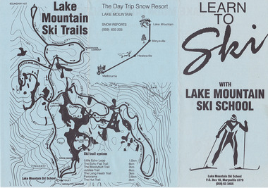
An advertising brochure for Lake Mountain Ski School in Victoria.An advertising brochure for Lake Mountain Ski School in Victoria. Marysville Ski Centre is a family-owned business, which has been operated by Nat and Beryl Morandi since 1981. The business started from very humble beginnings hiring toboggans at Lake Mountain initially from the back of a Bedford Van, and then upgraded to a rickety old shed with the addition of ski equipment for hire. In 1983, Marysville Ski Centre commenced business in its current position in Marysville. Then this building was destroyed, along with most of the buildings in Marysville, during the 2009 Black Saturday bushfires. Currently, the business operates from their new custom-designed ski hire which has been built to cater for the different needs of the hire.marysville, victoria, marysville ski centre, photograph, nat morandi, beryl morandi, 2009 black saturday bushfires -
 Marysville & District Historical Society
Newspaper (Item) - Newspaper article, Marysville Promotion Success, 1981
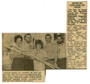
A newspaper article reflecting on the success of a display to promote Marysville and Lake Mountain. This display was the first of four displays over two weeks which was organised by Mrs. Connie Pannan from Nanda Binya Lodge in Marysville; Counselor Malcolm Reed from the Shire of Healesville and Marylyn Guest House in Marysville; Mrs. Val Cockerell from Blackwood Holiday Flats in Marysville; and Mr. Michael Cheshire from the Westernport Healesville Regional Tourist Authority. The display saw the release of a new full colour tourist brochure on Marysville produced with the co-operation of the Marysville Tourist and Progress Association and Westernport Healesville Regional Tourist Authority. It was deemed to be a most successful promotional event for Marysville and Lake Moutain.A newspaper article reflecting on the success of a display to promote Marysville and Lake Mountain. The Association was formed in November 1907 to promote tourism within the area. This included the physical creation of signage, parklands, roads and walks to various attractions. marysville, victoria, lake mountain, marysville tourist and progress association, newspaper article -
 Marysville & District Historical Society
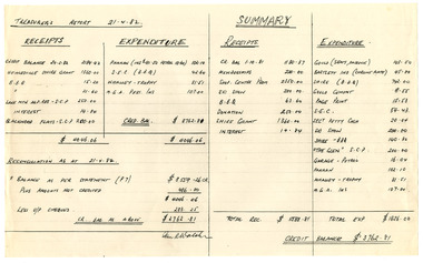
Ephemera (Item) - Treasure's Report, Treasurer's Report Wednesday February 24, 1982, 24-02-1982
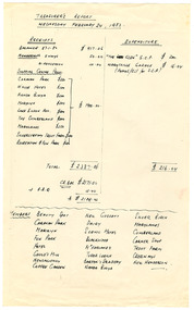
Marysville Tourist & Progress Association-Treasurer's Report-February 24, 1982Marysville Tourist & Progress Association-Treasurer's Report-February 24, 1982 The Association was formed in November 1907 to promote tourism within the area. This included the physical creation of signage, parklands, roads and walks to various attractions. marysville, victoria, lake mountain, marysville tourist and progress association, treasurer's report -
 Marysville & District Historical Society
Ephemera (Item) - Treasure's Report, Ian R Walsh, Treasurer's Report 21.4.82, 24-02-1982
Marysville Tourist & Progress Association-Treasurer's Report-21.4.82. At the time of this report, Ian R. Walsh was the Treasurer of the Association.Marysville Tourist & Progress Association-Treasurer's Report-21.4.82. The Association was formed in November 1907 to promote tourism within the area. This included the physical creation of signage, parklands, roads and walks to various attractions. marysville, victoria, lake mountain, marysville tourist and progress association, treasurer's report -
 Marysville & District Historical Society
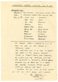
Ephemera (Item) - Treasure's Report, Ian R Walsh, Treasurer's Report - Thursday May 27, 1982, 24-02-1982
Marysville Tourist & Progress Association-Treasurer's Report-May 27, 1982. At the time of this report, Ian R. Walsh was the Treasurer of the Association.Marysville Tourist & Progress Association-Treasurer's Report-May 27, 1982. The Association was formed in November 1907 to promote tourism within the area. This included the physical creation of signage, parklands, roads and walks to various attractions. marysville, victoria, lake mountain, marysville tourist and progress association, treasurer's report -
 Marysville & District Historical Society
Ephemera (Item) - Tourist brochure, Victorian Railways, Marysville Victoria Australia, 01-1941
A tourist information brochure that was issued by the Publicity and Tourist Services of Victorian Railways, in January, 1941, to promote Marysville and the surrounding district.A tourist information brochure that was issued by the Publicity and Tourist Services of Victorian Railways, in January, 1941, to promote Marysville and the surrounding district.marysville, victoria, cumberland valley, messmate, buxton, taggerty river, acheron way, black's spur, cement creek, keppel falls, steavenson falls, cumberland falls, narbethong, st fillan, taggerty valley, wade's lookout, mount gordon, nicholls lookout, lake mountain, victorian government tourist bureau, victorian railways -
 Marysville & District Historical Society
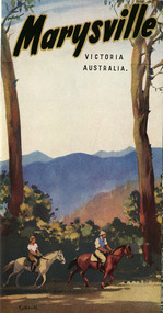
Ephemera (Item) - Tourist brochure, Victorian Railways, Marysville Victoria Australia, 01-1941
A tourist information brochure that was issued by The Victorian Railways Commissioners, in conjunction with The Marysville and District Tourist and Progress Association in 1948, to promote Marysville and the surrounding district.A tourist information brochure that was issued by The Victorian Railways Commissioners, in conjunction with The Marysville and District Tourist and Progress Association in 1948, to promote Marysville and the surrounding district.marysville, victoria, cumberland valley, messmate, buxton, taggerty river, acheron way, black's spur, cement creek, keppel falls, steavenson falls, cumberland falls, narbethong, st fillan, taggerty valley, wade's lookout, mount gordon, nicholls lookout, lake mountain, victorian government tourist bureau, victorian railways, marysville and district tourist and progress association -
 Marysville & District Historical Society
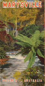
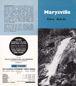
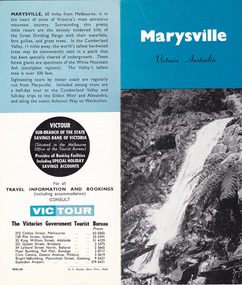
Ephemera (Item) - Tourist brochure, Victorian Government Tourist Bureau, Marysville Victoria Australia, Unknown
A tourist brochure showing showing information for travel to Marysville from Melbourne and accommodation venues in Marysville. This brochure was published by the Victorian Government Tourist Bureau.A tourist brochure showing information for travel to Marysville from Melbourne and accommodation venues in Marysville.marysville, victoria, australia, marysville hotel, the cumberland, kerami guest house, kooringa guest house, marylands guest house, mary-lyn guest house, marysville chalet guest house, marysville house guest house, mt kitchener guest house, lake mountain, mckenzie tourist services, melbourne, great dividing range, cumberland valley, white mountain ash, eildon weir, alexandra, acheron way, warburton, victorian government tourist bureau -
 Marysville & District Historical Society
Ephemera (Item) - Tourist brochure, Victorian Government Tourist Bureau, Marysville Victoria Australia, Unknown
A tourist brochure showing showing information for travel to Marysville from Melbourne and accommodation venues in Marysville. This brochure was published by the Victorian Government Tourist Bureau.A tourist brochure showing information for travel to Marysville from Melbourne and accommodation venues in Marysville.marysville, victoria, australia, marysville hotel, the cumberland, kerami guest house, kooringa guest house, marylands guest house, mary-lyn guest house, marysville chalet guest house, marysville house guest house, mt kitchener guest house, lake mountain, mckenzie tourist services, melbourne, great dividing range, cumberland valley, white mountain ash, eildon weir, alexandra, acheron way, warburton, victorian government tourist bureau -
 Greensborough Historical Society
Map, Melbourne and Metropolitan Board of Works. Survey Division, MMBW, Yarra 2500 / 12.24. Plenty and Blue Lake, 1977_10
... of Whittlesea 239 and Diamond Valley 257. Shows street names, easement ...Melbourne and Metropolitan Board of Works. Yarra 2500 [base map]. 12-24, Municipalities of Whittlesea 239 and Diamond Valley 257. Shows street names, easement sizes, lot numbers, lodged plan numbers, names of prominent features, contour values, creek or river names. Watsonia Railway Station and environs. Prominent streets: Memorial Drive. Includes Plenty River and Blue Lake in the Plenty Gorge.MMBW Map in 1:2500 [scale] series. Cream parchment with green tape reinforcing on edges and punched holes on left edge.mmbw, melbourne and metropolitan board of works, shire of diamond valley, plenty - maps, blue lake -
 Greensborough Historical Society
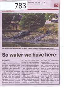
Newspaper clipping, Diamond Valley Leader, So water we have here, 16/01/2013
This article is about the recovery of stolen vehicles from the Kalparrin Lake after it was drained as a part of the Stormwater harvesting project. Other items recovered included a safe, shopping trolleys, an engine block, five bicycles and hundreds of tennis balls.The Stormwater will be used to water parklands and create a wetland at Kalparrin.A small newspaper article featuring a colour photograph.kalparrin reserve, stormwater harvesting, stolen cars -
 Halls Gap & Grampians Historical Society
Magazine - Photocopy
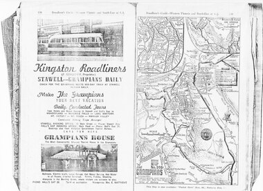
Kingston Roadliners (F. Kingston, Proprietor) STAWELL - GRAMPIANS DAILY Coach for the Grampians meets mid day train at Stawell Return Daily Make the Grampians your next vacation Daily Conducted Tours, from Hotels and Guesthouses in Stawell and Hall's Gap to WONDERLAND - MCKENZIE FALLS - LAKE WARTOOK - MT. VICTORY - MT ROSEA - WANNON VALLEY conducted Hiking Trips Arranged Stawell booking office: 75 Main Street - Phone: Stawell 214, Hall's Gap booking office: Main Road - Phone: Hall's Gap 35, Bookings also from Vitorian Government Tourist Bureau, Cars for hire GRAMPIANS HOUSE The Most Conveniently Situated Tourist House in the Grampians. Ballroom, electric light, large garage, hot water service, hot water in all rooms, internal sewerage. Tennis, fishing, shooting, Alongside is the Bowling Green, where visitors are welcome to play. Phone: Hall's Gap 28. Tariff on application. Manageress: Mrs, E. MatthewsAdvertisement for Kingston Roadliners, Grampians House and Map of the GrampiansAdvertisement in Broadbents, Guide of western Victoria, and South-East of S.A.media, advertisements, grampian house -
 Halls Gap & Grampians Historical Society
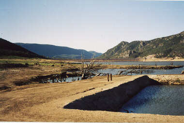
Photograph - Coloured, C 2007
This is a photo of the exposed swimming pool of Myrtlebank, which became exposed in Lake Bellfield during the drought years (2007 - ). The view is looking towards the dam wall and further road through the valley..Photo shows an exposed swimming pool (Myrtlebank Pool) in a very low reservoir (Lake Bellfield). There are dead branches in the water behind the pool and the dam wall and former road through the valley can be seen in the background.recreation, swimming pool -
 Halls Gap & Grampians Historical Society
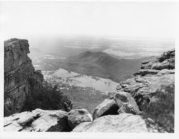
Photograph - B/W
The photo is of the Fyans Valley, taken from Chatauqua Peak. Lake Bellfield and Mount William can be seen in the background. The photo belonged to the Forestry Commission Victoria.A photo of a valley between mountain ranges. A lake can be seen in the background. A road runs through the middle of the valley with houses on both sides."Fyans Vaslley from Chataqua Peak. Incl L. Bellfield & Halls Gap. photo belongs to F.C.V. Stawell. Return to V. Young, Horsham" written on back in green pencil. The "Chatauqua Peak" has been overwritten in black-lead pencil. "LC.71" is also written on the back in black-lead pencil.scenery, grampians ranges -
 Halls Gap & Grampians Historical Society
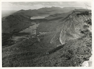
Photograph, C 1960s
The valley is known as Fyans Valley and the township of Halls Gap. Photo is typical of those taken by the Forestry Commission (Vic) during the 1960s.Photo shows two rocky outcrops in the foreground framing a valley in the distance below. A partial view of a mountain range flanks the valley. Plains of trees and open fields, and also a lake, can be seen beyond the mountain range. Within the valley in the middle of the photo buildings, roads and cleared land can be seen.scenery, fyans valley -
 Kiewa Valley Historical Society
Postcard Circa 1950, Lake Guy Dam and Bogong Village, Circa 1950
This postcard was produced in the 1950's for the tourist trade in the Kiewa Valley and Alpine region. It encompasses the period when the State of Victoria was pressured by the ever increasing demand by industry and its population for electricity supplies. Hydro electricity was seen as an untapped natural resource to quench this demand. The Victorian Alps and the rivers flowing into its valleys was ideal for the construction of the Kiewa Hydro Electricity Scheme. The late 1940's saw the development of this scheme and the changing of sections of alpine landscape is covered by this and other postcards/pictures (tourists, construction workers, and established rural populations). This period in time was before the established wildlife and forest/nature groups became political activist who changed legislative acts to protect the environment.This rural region (Kiewa Valley/alpine plains) was at most only significant to a smaller group of winter sports, summer hikers/horse riders and rural farmers/graziers. The numbers of tourists and the increase in the local resident population was boosted by the construction of the Hydro Electricity Scheme. This influx to the regional population resulted in a corresponding diversity in services and brought about an environment that responded to a growing level of tourists and thereby permitting this industry to grow more rapidly than it would have naturally. This postcard details an attraction to the "cleaner" method of providing electricity. This postcard was purchased in 1950 by a surveyor at Landford's Gap.This black and white photograph from a Valentine's postcard is from a V2 Argus photograph postcard. It is on a 200g/m paper density photo side gloss. See 0480 (B) - (F) for other photos of similar postcards.In white lettering " LAKE GUY & BOGONG VILLAGE KIEWA HYDRO-ELECTRIC PROJECT"kiewa valley tourism, victorian alps, alternate energy supplies, alpine population growth -
 Kiewa Valley Historical Society
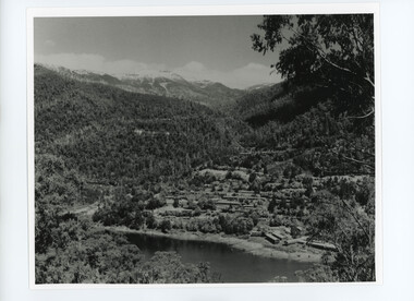
Photograph from Lake Guy, Bogong Village, Scene from shores of Lake Guy to Mountain range, 1930s to 1950s
... of the Kiewa Valley Tourist Industry. The lake is one of the many water ...In 1940 Field Headquarters for the Kiewa Scheme were established at Bogong with office, workshop facilities and accommodation for workmen, staff and some families constructed. (There had been a 'tent camp' on this site in 1939 but was destroyed by bushfires) Construction of accommodation continued until 1947. A total of 40 houses plus a hostel for single staff, post office, police station, medical centre and primary school all with water and sewerage and electricity supply. The staff hostel was known as Kiewa House and is now occupied by the Education Department. Lake Guy was named after Mr. L.T. Guy who was the Resident Engineer in charge of construction work and associated activities on the Kiewa area. He held this position from 1939 to November 1946 when he was transferred to Head Office.The Bogong Township was developed firstly as an accommodation centre (base camp) for construction workers employed under the Kiewa Hydroelectric Scheme. Due to the influx of European workers into the Township the beautification of the immediate surrounds(gardens etc.) had a distinct European flavour. This environment has been very beneficial for tourism in later years. Strict environmental control has not allowed for any extensive redevelopment in tourist accommodation and basically restricted it to the accommodation initially built for the construction workers. Activities such a bike riding, snow skiing, restricted horse riding and bush walking on the Alpine plains and mountains are now a viable part of the Kiewa Valley Tourist Industry. The lake is one of the many water storage storage reservoirs used to supply the power stations their main power to run the huge turbines generating the final product, electricityThis black and white photograph shot from the shores of Lake Guy toward the mountain range of the Victorian Alps details the early construction of the construction worker's accommodation of the Bogong Village. The paper is of 200gms and is not photographic paper and can be assumed to be a reproduction of an original photobogong village circa 1930 to 1950, kiewa hydro-electricity scheme, victorian alpine region mid 1900s -
 Kiewa Valley Historical Society
Photo Album - Country Women's Association of Victoria, 1990's
The Tawonga branch of the C.W.A. commenced on the 7th Feb. 1946 and often combined activities with the other branches in the Kiewa Valley. The C.W.A. aimed to improve health, welfare and education for women and children in the country. The Tawonga ladies competed in Handicraft and Home Industries Exhibitions during the 1990's and were very successful. Women living in Tawonga were mostly on farms and, in 1946, when the branch commenced would have been feeling more remote with WW11 having had an effect on available workers and the well being of the women and children.Small photo album with Country Women's Association Prize Cards for handicraft and Home Industries Exhibition enclosed. Each Prize Card is filled out with (Third) Prize; Name; No.; Section; Branch - all Tawonga; and points. Some of the cards have been won from other CWA groups displays e.g.. Yackandandah. The album has several blank pages left over. The cover is a picture of a boat on a lake with red flowers in the foreground.country women's association of victoria. tawonga. handicraft. home industries. exhibition. kiewa valley group.c.w.a. -
 Kiewa Valley Historical Society
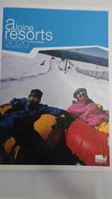
Book - Alpine Resorts - 2020 draft strategy, Alpine Resorts 2020 draft strategy
This is a commissioned report auspiced by the State Government of Victoria - Department of Sustainability and Environment 2003.This report was prepared to guide the sustainable long-term planning and management of Victoria's six Alpine Resorts. Falls Creek, Lake Mountain, Mount Baw Baw, Mount Buller, Mount Hotham and Mount Stirling, after the catastrophic bush fires of 2002- 2003.Colorured cardboard front cover with two people on air mattresses in foreground. Title white on bue top left corner. 40 glossy thick paper/card pages. A4Logo "Victoria / The Place to betourism in alpine resorts, sustainability and environment, victorian government, 2002-2003 bushfires -
 Kiewa Valley Historical Society
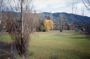
Photos - Coloured - Mt Beauty surrounds
5 coloured photos of Mt BEauty surrounds including golf course, lake, mountain with snow and camping -taken recentlymt beauty -
 Kiewa Valley Historical Society
Photos - Junction Dam Spillway, Kiewa Hydro Electric Scheme
2 black and white small photos titled - A. 'Bogong Village, Kiewa Hydro Electric Project' and B. 'Junction Dam & Spillway, Lake Guy, Bogong, Kiewa Hydro Electric Project' -
 Kiewa Valley Historical Society
Photo - Bogong Village and Lake Guy
Large black and white photo of Bogong Village and Lake Guy dated September 1953Sticker on the back "Bogong Village Management 27 Main Street, Bogong 3699. Facsimile (057) 57 3391 Telephone (057) 57 3300 -
 Kiewa Valley Historical Society
Photos - Bogong Village
x14 B & W photos of Bogong Village with title, in white, on bottom left hand cornerSome have a title in white on the front. x2 Lake Guy; Spillway; x3 Bogong; Interior of Wall; Trs Workings; Bogong Hostel; The Wall; Snow at Bogong; S.E.C. House -
 Kiewa Valley Historical Society
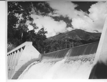
Photograph of Lake Guy Dam, Spillway, Lake Guy Dam, c1945
In December 1939 the excavation of the diversion tunnel at the site of Junction (Lake Guy) Dam was commenced and finished in February, 1940.This allowed the stream to be diverted to facilitate the dam wall construction. This is a 'slab and buttress' dam. It is framed with timber and concrete then poured into the structure. A contract was let to Lewis Construction Co. for the construction of the dam, and the first batch of concrete was placed in September, 1940. Industrial trouble caused some delays but there was also slow progress on the part of the contractor and the work was taken over by the S.E.C., terminating the contract. The dam was completed in March, 1944. The lake is named after Mr. L.T. Guy who was the Resident Engineer, in charge of construction work and associated activities on the Kiewa area, from 1939 until November 1946. An historical pictorial record taken for the State Electricity Commission of Junction Dam (Lake Guy) on spill. Mt. Arthur is in the background and there is still evidence of the destruction of trees from the 1939 bushfires. Black and white photograph of Lake Guy Dam . The dam is spilling and Mt. Arthur is in the background. Hand written on back of photograph in blue ink " Lake Guy Dam".dam, lake, water, mr. l.t.guy -
 Kiewa Valley Historical Society
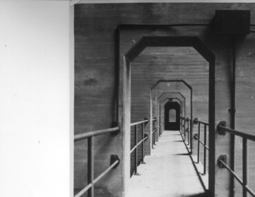
Photograph of Lake Guy Dam, Walkway, Inside Lake Guy Dam, c 1945
Lake Guy Dam is a 'slab and buttress' type wall. A timber frame is built and then filled with concrete. The first batch of concrete was placed in September, 1940. By June, 1941 the buttresses were finished to a height safe from floods and in October of that year a flood of 2,800 cusecs occurred but with only slight damage to the installations. Industrial trouble caused some delays but there was also slow progress on the part of the contractor and the work was taken over by the S.E.C., terminating the contract. The dam was completed in March, 1944. A walkway was made through the dam wall. Lake Guy was named after Mr. L.T. Guy who was the Resident engineer, in charge of construction work and associated activities on the Kiewa Area from 1939 to November 1946.Shows the walkway placed as part of the Lake Guy (Junction) Dam wall. A very good pictorial reference for the future.Black and white photograph of the walkway through Lake Guy (Junction) Dam wall.Handwritten in blue ink on back of photograph "Inside Lake Guy Dam". slab, buttress, dam, mr. l.t. guy -
 Kiewa Valley Historical Society
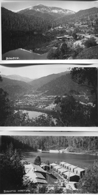
Book - Non Fiction History, The Kiewa Story, circa 1993
This book provides in chronological order the development of the Kiewa Hydro-electricity scheme from the first concept (1911) to final construction work (1961). It covers the first attempt to utilise the power of the Victorian Alps water system. It started from a private syndicate and developed to the current State Electricity Commission of Victoria. The incentive for the Hydro scheme was to make money and not as an alternative to the carbon producing coal fired power plants. These coal fired power plants were increasing in numbers to service an ever increasing demand made by population expansion, especially in cities and large rural settlements. This demand spiraled up after World War II when there was a tremendous spike in immigration numbers due to refugees and displaced persons in Europe. The ability to utilise the untapped water provided by the winter snow fields, for a higher yield in electricity, was a powerful incentive to overcome the physical hardships in this remote Alpine region. Future power requirements may initiate the re-installation of the other two power stations(Pretty Valley and Big Hill) covered in original Scheme. This publication not only covers the development of the Kiewa Valley region with respect to population (within a socio-economical framework) but also the subtle but yet strong physical changes of a relatively pristine alpine region. The demands that an ever growing regional population places on the environment is clearly documented in print and black and white photographs. The working and living conditions of those who constructed and gave life to this hydro scheme is well documented in this book. It may be viewed as spartan now but was relevantly good at that moment in time, especially for those workers fleeing a devastated European environment. The successful planning and consideration to minimising any intrusion upon the natural alpine forests and high plains can viewed as an example (compared to the Tasmanian Hydro schemes) of how future hydro schemes (an inevitable requirement) will proceed. Most rural towns (in the early 1900s) were built by unencumbered rural based citizens, with the exception of Mount Beauty and Falls Creek. These two settlements were brought into life by a State (Victorian) Authority for a specific function and program. They were a gated community, that is, only open to construction workers involved with the hydro scheme. All facilities within these communities were provided by the State Electricity Commission of Victoria. The impact on the social, financial and individual independency of the community, by the transition from the S.E.C .environment to one of local government (Shire of Bright), had in some cases a severe impact.This hard covered book has a green cover with pictures on the front and back covers. The front cover has a coloured picture of a snow covered Mount Bogong taken from the opposite mountain range. The valley between both ranges has a whisk of mist over it. At the bottom of this picture are three black and white photographs covering the construction of the Kiewa Hydro - Electricity Scheme. On the back cover is a photograph, (black and white) detailing the Bogong village and Junction dam containing lake Guy. The inside front cover is a black and white photograph which details the construction of the West Kiewa tailrace tunnel during April 1951. The inside back cover is a black and white photograph of the concrete pour at the Clover Dam circa 1952. All photographs and sketches are in black and white. The pages are approximately 160 g/m2 and those which have photographs are on gloss paper.Book spine: "The Kiewa Story Graham Napier Geoff Easdown" alongside this is a white framed circle with white spokes radiating out and underneath in white lettering SECkiewa valley, hydro scheme, victorian alpine region, electricity generators, graham napier, geoff easdown