Showing 14991 items
matching view to
-
 Marysville & District Historical Society
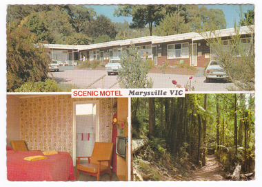
Postcard (item) - Colour postcard, R. Bell, SCENIC MOTEL Marysville VIC, Unknown
A colour postcard of the Scenic Motel in Marysville. The postcard was produced by Bellevue Color Views Australia as a souvenir of Marysville.A colour postcard of the Scenic Motel in Marysville. The postcard was produced by Bellevue Color Views Australia as a souvenir of Marysville.Produced/ and/ Printed/ in/ Australia Bellevue Color Views Australia Colour photography by R. Bell/ Box 37, Ormond Vic. SCENIC MOTEL/ 5 DARWIN STREET,/ MARYSVILLE, VICTORIA, 3779/ Phone: (059) 633 247 "The little Motel with the big view" Quite location, all facilities, Barbeque,/ parking at door, moderate tariff, personal/ attention from your hosts. BV 366marysville, victoria, australia, scenic motel, accommodation, postcard, souvenir, bellevue color views australia, r. bell -
 Stawell Historical Society Inc
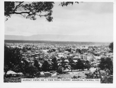
Photograph, Panorama of Stawell from Pioneers Memorial. Murray Views No. 4
Panorama of Stawell from Big Hill. Murray Views No. 4. View from Pioneer Memorial Post c 1939Black & White photo of Stawell from Pioneers Memorial post c 1939. Murray Views No. 4, View from Pioneer's Memorial Stawell, Vic.stawell, panorama -
 Port Melbourne Historical & Preservation Society
Photograph - Canal at Fishermen's Bend, 1886
View of canal at Fishermen's Bend 1886. East end - showing inflow of water, during flooding.On rear: SLTF 919.45 M48F Views of canal at Fishermen's Bend 1886. View No 5 - General view East end - inflow of water.engineering - canals and drainage -
 Lakes Entrance Historical Society
Postcard - Omeo Victoria, H D Bulmer, 1940 c
Black and white postcard showing an aerial view of the roads and country surrounding the mining town of Omeo VictoriaAerial view of Omeohotels, transport -
 Mt Dandenong & District Historical Society Inc.
Photograph, View From Ernest Road To Site Of "Kia-Ora"
... View From Ernest Road To Site Of "Kia-Ora". ...John Lundy-Clarke grew up in the Kalorama/Mt Dandenong area and later in life (1972-74) began to write a comprehensive history of the area working from an original settlement map in an effort to cover all areas. The photograph taken c1973 from Ernest Road looks over the site of the Kia-Ora guesthouse which is marked by the oalm tree that can be seen at the front of the flat roof close to the gum tree trunk. Situated on Barber’s Road, ‘Kia-Ora’ was built in 1912 by George Barber. It was later leased by a Mrs Pemberthy. “Kia-Ora’ was one of four places connected when the telephone was brought into the district in 1912. The other places were ‘Mountjoy’, ‘Cherry Farm’ and ‘Callum House’. ‘Kia-Ora’ was burnt down in 1924.Black and white photograph showing a house with water tank in right foreground and another flat roof centre foreground. There is a handwritten description by John Lundy-Clarke on the reverse.View 1973 from corner of Ernest Rd and Outlook Drive Lot 24 Village Settlement looking over the site of “Kia Ora” to the pioneers clearings. The palm tree seen above the flat roof (Rex) on left, is on the exact site of “Kia Ora”. Photo JLCernest road, john lundy-clarke, kia=ors, guest house, guesthouse -
 Robin Boyd Foundation
Slide, Robin Boyd, 1950
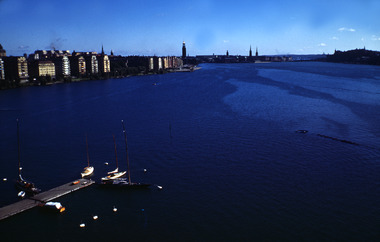
Penleigh Boyd, Robin and Patricia Boyd's son, writes “Prior to 1950 Robin, like most other amateur or hobby photographers, took black and white printed photographs. The oldest slides date from 1950 when Robin and Patricia travelled to Europe on Robin’s Robert Haddon Travelling Scholarship.” In 1948 Robin Boyd was awarded ‘joint first place’ in the Robert Haddon competition for his design of Mildura art gallery. The scholarship helped fund their first overseas trip. Robin and Patricia were passengers on the Greek ship “Cyrenia” departing in May 1950, passing through the Suez Canal and landing in Genoa five weeks later. For six months, they travelled extensively throughout Europe (predominantly driving themselves) - France, Italy, United Kingdom, Sweden, Denmark, Germany, Austria, Switzerland and Spain.Colour slide in a mount. View for bridge, Stockholm, SwedenStockholm / View / From Bridge (All Handwritten)haddon travelling scholarship, haddon, robin boyd, slide -
Glenelg Shire Council Cultural Collection
Souvenir - Souvenir Plate - Casterton, Victoria, n.d
Souvenir dish, white china, fluted edge, gold rimmed; view of Casterton, Victoria, colouredFront: 'Greetings from' - gold lettering above view 'View at Casterton Vic.' below view Back: 'WILLOW', maker's mark, 'Made in Stoke on Trent England'souvenir, casterton, victoria -
 Stawell Historical Society Inc
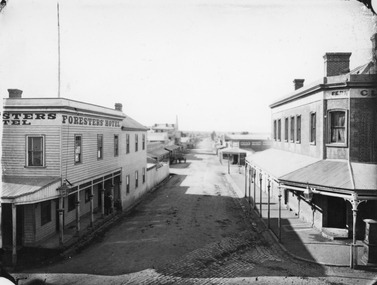
Photograph, Main Street & Patrick Streets corner looking East down Patrick Street with the Foresters Hotel on left corner 1878
First floor view from corner of Main & Patrick Streets looking East down Patrick Street. Weatherboard Foresters Hotel in Main Street on left corner. Foresters Hotel was built in 1868 by Mr. Joseph Cawley, Mr. and Mrs. Cawley were the occupants for 30 years. The site was previously occupied by a Billiards Room. In 1917 the building became Foresters Coffee Palace with new owner Mr. J.C. Crothers who purchased the building for 410 pounds and leased it to Mr. Robert Wennerbom. The next lease holder was Miss Fulton and in 1921 Mrs. R. Claringbold took over and called the building Foresters House. The building was sold in 1935 and demolished shortly after sale. Businesses visible down Patrick street, Foresters Hotel, J.H. Wallis Royal Exchange Hotel on Big Hillside of Street. With St Patrick's church tower visible in distance. Melbourne Cash Store Wines and Spirits on corner of Patrick and Sloane Street near centre of photo. Ferns Hotel / Times office on right of photo, corner of Patrick and Main Street. Post Box on Corner at right of photo. 1878First floor view from Main Street Patrick Street intersection looking down Patrick Street. Foresters Hotel on left. Fern Boarding House on right.Victorian Views. C. Herbert, Photo. Stawell 1878stawell businesses streetscape -
 Kew Historical Society Inc
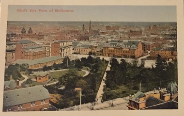
Postcard, Bird's Eye View of Melbourne, c.1911
Collection of thirty-nine postcards donated by Jillian Rigby which had been owned by her grandparents, George and Edith Weir, who from c.1917 lived at 84 Princess Street, Kew. The mostly 'mint' postcards were purchased in Victoria and while travelling overseas. The sole dated postcard is dated from 1929. The postcards are numbered sequentially from 2017.0058.01-39. The remainder of the collection donated by Jill Rigby which was once owned by the Weirs of Broken Hill and Kew consist of costumes, costume accessories, photographs, and documents.The postcards in the Weir collection, especially those purchased on a trip or trips to the mother country, i.e. United Kingdom, represent a representative sample of sites that were considered significant to those Australians undertaking a reverse grand tour by member of the erstwhile colonies. Those postcards which are early views of Melbourne must have been produced commercially for some decades from the early part of the 20th century.Bird's eye view of Melbourne looking across a park to the Princess Theatre. Coloured postcard. Weir collection."Bird's Eye View of Melbourne"postcards, george and edith weir, princess theatre, eastern hill - melbourne, weir collection -
 Kew Historical Society Inc
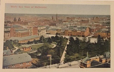
Postcard, Bird's Eye View of Melbourne, c.1911
Collection of thirty-nine postcards donated by Jillian Rigby which had been owned by her grandparents, George and Edith Weir, who from c.1917 lived at 84 Princess Street, Kew. The mostly 'mint' postcards were purchased in Victoria and while travelling overseas. The sole dated postcard is dated from 1929. The postcards are numbered sequentially from 2017.0058.01-39. The remainder of the collection donated by Jill Rigby which was once owned by the Weirs of Broken Hill and Kew consist of costumes, costume accessories, photographs, and documents.The postcards in the Weir collection, especially those purchased on a trip or trips to the mother country, i.e. United Kingdom, represent a representative sample of sites that were considered significant to those Australians undertaking a reverse grand tour by member of the erstwhile colonies. Those postcards which are early views of Melbourne must have been produced commercially for some decades from the early part of the 20th century.Bird's eye view of Melbourne looking across a park to the Princess Theatre. Coloured postcard. Weir collection."Bird's Eye View of Melbourne"postcards, george and edith weir, princess theatre, eastern hill - melbourne, weir collection -
Canterbury History Group
Photograph - View looking outside to Maling Road from inside No. 88 Maling Road, Jan Pigot, 27/03/1993 12:00:00 AM
... View looking outside to Maling Road from inside No. 88 ...Coloured photograph from inside the Maling Road Patisserie at No. 88 Maling Road looking through the front window to the shops across the road.canterbury, maling road, shops, street views -
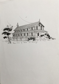 Kew Historical Society Inc
Drawing, Dione McIntyre, Rear view of 'old' St Hilary's, 2013
The first St. Hilary’s Church of England (Kew) was a timber building on the corner of John and Rowland Streets, designed in 1888 by Albert Purchas. This timber building was demolished in the 1940s to make way for a new church and tennis courts. The drawing was made to accompany a newsletter article by Dione McIntyre.Pen and ink drawing of the rear view of ‘old’ St Hilary’s, drawn by Dione McIntyre, 2013. "Rear view of 'old' St Hilary's"st hilary's church (kew), dione mcintyre, churches -- kew (vic) -
Glenelg Shire Council Cultural Collection
Photograph - Photograph - aerial view of Portland harbour, 1960
Port of Portland AuthorityFront: Harbour: Aerial view south. July '60 - typed, bottom.port of portland archives, aerial photography, portland harbour -
 Ballarat Tramway Museum
Slide - 35mm slide/s, Ben Parle, Jan. 1954
Kodachrome Transparency - 35mm slide - cardboard mount, with one side with red border and words "Kodachrome Transparency" top and bottom. On the other side is "Made in England" and "View from this side". Photo taken by Ben Parle 1/1954. Photo of Ballarat No. 14, leaving the Victoria Ave. or View Point Loop, Wendouree Parade, northbound past the View Point Hotel to the View Point terminus. Note the wiring through the loop has been altered to run via the straight track only. See Reg Item 5514 for Wal Jacks notes on this removal of the trolley wire. "View Point Ballarat" "1/54"tramways, trams, wendouree parade, view point, victoria ave loop, tram 14 -
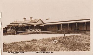 Phillip Island and District Historical Society Inc.
Photograph
Part of collection donated to the Museum by Mr. Bernard Grayden. 1975Postcard of Bay View Guest House and Tennis Court, Cowes.The Rose Series P10479. "Bay View" Cowes, Victorialocal history, documents, postcards buildings, historic, guest house, phillip island, sepia postcard, bay view guest house, cowes, bernard grayden -
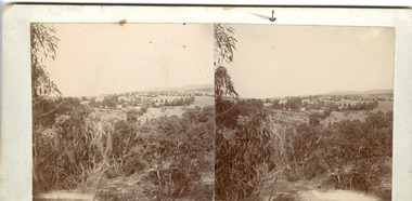 The Beechworth Burke Museum
Photograph - Stereoscopic Photograph
This photograph offers a view of Beechworth, located at the foot of the Victorian Alps. It captures the gorge and native vegetation in the foreground, with the Beechworth township visible in the middle, where the hospital is marked with an arrow. Distant hills form the backdrop. Originally settled c1839, Beechworth was officially proclaimed a town in 1856.This photograph is historically significant as it captures the landscape of Beechworth, providing valuable insight into the town's visual and historical character.Two sepia-toned square photographs showing the view of a town with trees in the foreground and hills in the far distance, mounted.Obervse: Above the right photograph there is an arrow pointing down. Reverse: 97.2195/ View across the Gorge/ looking over Beechworth/ (Hospital under arrow)/ 84-110-1/ A03082beechworth, town, landscape, ovens district, stereoscopic -
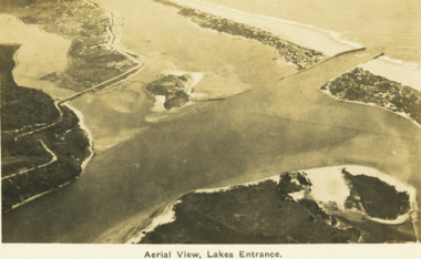 Lakes Entrance Historical Society
Postcard - Aerial view Lakes Entrance, H D Bulmer, 1922 c
Image clearly shows new alignment of Princes Highway around Jemmys Point and part of the original high road to the first bend above North Arm BridgeBlack and white postcard aerial view of the western area of the town, Bullock Island and Snake Island and waterways Lakes Entrance VictoriaAerial View Lakes Entrancewaterways, islands, township -
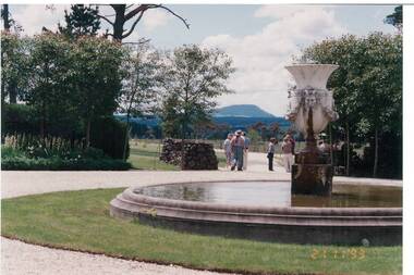 Buninyong & District Historical Society
Photograph - Colour photograph of fountain in the garden at Larundel, Fountain in the garden at Larundel
Larundel was built by the Austin family in the mid 19th century as part of a successful agricultural estate that is still prosperous in the 21st century.The original estate was developed by the Austin family and reflects the boom era prosperity that defined late 19th century Victoria View of fountain and visitors to the garden at Larundel, Mount Buninyong is visible in the background"Larundel" garden, with views to Mt. Buninyong, Nov 1993early settlement, mount buninyong, austin family, gardens -
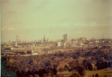 Kew Historical Society Inc
Photograph - View of City from Nurses’ Hostel : Kew Mental Hospital, 1960s
This photograph is one of approximately 43 original photographs and photocopies of buildings, patients and staff assembled in a red covered, spirally bound photograph album (the album itself is now discarded and the images stored separately). The images in the album cover the period from the 1870s to 1965. A few photographs have inscriptions on the reverse; others had later separate labels in the album. The album was presumably compiled as a public record. It and other items came from the collection assembled by Dr Fred Stamp, the last medical superintendent of Willsmere Hospital before its closure in 1988. Original photographs have been uploaded to and described on Victorian Collections. The album itself is listed and linked separately showing the photographs in situ.A number of the photographs from the Willsmere Hospital album are confronting, especially given the condition of the buildings and facilities depicted, as well as the casual photographs of patients, which some viewers may find distressing. The album and its photographs are however an historically significant visual record of the Kew Mental Hospital, especially in the years 1951-1965.Small colour photograph of the view of Melbourne from the Nurses’ Hostel, Kew Mental Hospital."View of City from Nurses’ Hostel, Kew"kew lunatic asylum, kew hospital for the insane, kew mental hospital, kew mental institute, willsmere mental hospital, willsmere hospital -
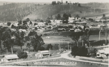 Lakes Entrance Historical Society
Postcard - Bruthen Victoria, H D Bulmer, 1930 c
Black and white postcard of a general view of town taken from railway station, Bruthen Hotel top right background, railway crossing lower right, Bruthen VictoriaGeneral View Bruthentownship, land settlement -
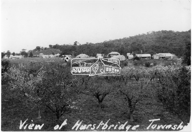 Eltham District Historical Society Inc
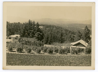
Photograph, View of Hurstbridge township
View across an orchard of flowering fruit trees towards the small township of Hurstbridge. Around 1920s.This photo forms part of a collection of photographs gathered by the Shire of Eltham for their centenary project book, "Pioneers and Painters: 100 years of the Shire of Eltham" by Alan Marshall (1971). The collection of over 500 images is held in partnership between Eltham District Historical Society and Yarra Plenty Regional Library (Eltham Library) and is now formally known as 'The Shire of Eltham Pioneers Photograph Collection.' It is significant in being the first community sourced collection representing the places and people of the Shire's first one hundred years.Digital imageView of Hurstbridge townshipsepp, shire of eltham pioneers photograph collection, hurstbridge, orchards -
 Mt Dandenong & District Historical Society Inc.
Photograph, Walker's LOT 2
Harry Walker's property would have been run by his son William in 1922. When the CRB Road cut through the property William planted plum trees on the opposite side. These are visible in this photo. An extensive raspberry crop is in the foreground. The building over the road on the left hand side is the corn and produce store built by Edward John Price (son of Edward Joseph Price) to capitalise on the CRB Road cutting through the Price farm. John Lundy-Clarke grew up in the Kalorama/Mt Dandenong area and later in life (1972-74) began to write a comprehensive history of the area working from an original settlement map in an effort to cover all areas.Small black and white postcard showing a crop in foreground with a house to the right. A road passes through the centre with a house on the left on the opposite side of the road. A view to the ranges in the distance. A handwritten description on reverse by John Lundy-Clarke.View at Kalorama. View over LOT 2 (Walkers) 1922.harry walker, william walker, crb road, raspberry, edward john price, edward joseph price, produce store, store -
 Bendigo Historical Society Inc.
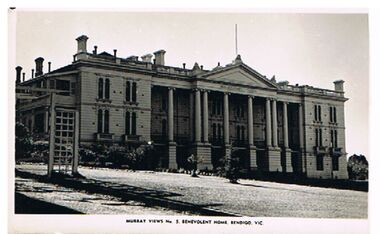
Photograph - BENEVOLENT HOME, BENDIGO
black and white photo: Benevolent Home, Bendigo. Two storey building with columns supporting pediment. Lawn and some garden along front of building. On bottom of photo: ' Murray Views, No. 5 Benevolent Home, Bendigo, Vic.'Murray Viewsbuildings, hospital, benevolent home, benevolent home, bendigo, aged care, hospital -
 Bendigo Historical Society Inc.
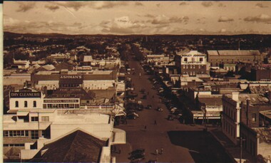
Photograph - CARWARDINE COLLECTION: HARGREAVES STREET BENDIGO, 1930/40's
Sepia photograph. Murray Views No 4 Hargreaves Street, Bendigo, Vic., showing the Ashmans Dry Cleaners, Ashmans Tailor, Ashmans Fine Suits & Morley Johnson Furniture also visible is the SEC building and other buildings.Murray Viewsphotograph, streetscape, bendigo, bendigo-history-businesses -
Tatura Irrigation & Wartime Camps Museum
Photograph - copy, Dean Clark, copy 1989
Managers residence occupied by Mr and Mrs J. Lowry.Black and white photograph of north view of managers residence, Dhurringile Mansion in distance.On back: Nth view managers residence, Dhurringile Mansiondhurringile mansion, managers residence, lowry -
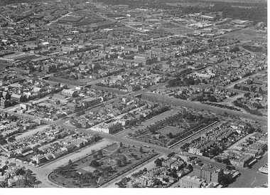
 Camberwell Historical Society
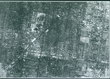
Photograph, Camberwell Victoria, aerial view of the District, c. 1940
Print of photograph with inscription 'Camberwell Victoria, aerial view of the District, c. 1940' Camberwell Victoria, aerial view of the District, c. 1940camberwell -
Stawell Historical Society Inc
Map, Stawell Gold Mine, Three dimensional View of Magdala Decline, March 1994
View of Mine looking from Stawell Hospital towards Big Hill Levels indicate depth in metres below hillParallel View Scale 1 : 2600mining, gold -
 St Kilda Historical Society
Photograph, City of Port Phillip, 1/1/1900
foreground showing St Vincent's Gardens, c1900postcard black and white arial view of South Melbourne St Vincent Gardens and ariel view of South Melbourne circa 1900. -
 Greensborough Historical Society
Photograph - Digital image, Charles Marshall et al, Church at Mataria, 1917_
This photograph shows a view of the outside of a Church in Mataria, near Cairo. Digital copy of black and white photograph. "View of outside of church Matarich"charles marshall, world war 1 -
Glenelg Shire Council Cultural Collection
Photograph - Photograph - Portland Harbour, n.d
Black and white photo. View over harbour to Portland, taken from Battery Point.Back: 'Panoramic view of Portland from Battery Point'portland harbour, battery point