Showing 202 items
matching walking tracks
-
 Falls Creek Historical Society
Photograph - Jack Maddison Leading horses on the Bogong High Plain
... Hut. Staircase Spur walking track at Bogong was formerly known... Hut. Staircase Spur walking track at Bogong was formerly known ...The images in the Bogong Village Collection were displayed in Bogong Jack’s Tavern for over 20 years and were donated to the Falls Creek Museum when the Tavern closed in 2021. In 1939, the State Electricity Commission of Victoria established a field headquarters at Bogong to house workers and their families for the Kiewa Hydroelectric Scheme which ran from the 1930s to the 1960s. The workmen's camp was originally started with tents and was called Junction Camp. By 1947, the village supported 300 workers and their families. It included 40 houses, a hostel for single staff, a post office, a police station, a medical centre, and a primary school. The staff hostel was known as Kiewa House. At the completion of the Scheme, in the 1960s, the village was opened to public/tourism use. In 1968 the Victorian Education Department acquired the camp buildings and four houses from the State Electricity Commission of Victoria to establish an Outdoor Education Centre which operated for over 50 years. The Kiewa Hydroelectric Scheme was privatized in the 1990s and sold to Southern Hydro, before being acquired by AGL in 2005. In 2023 the Grollo Group signed a 73 year sublease on Bogong Village and has plans for its redevelopment as a workers’ village. John Maddison and his wife Mary Padman emigrated from London to Australia in 1850 with their five sons. Jack (John James William Maddison) was one of their great grandsons. In 1877 Jack’s grandfather George Maddison selected land between the East and West Kiewa branches of the Kiewa River - known as the "Island". It is now known as Mount Beauty. The Maddison family built Aertex Hut at the top of T Spur at Mt. Bogong for use when grazing cattle. It later became known as Maddison's Hut. Staircase Spur walking track at Bogong was formerly known as Maddison’s Track as it is the path once used by the Maddison family to drive their cattle on to the high plains. These images are significant because they feature the son of a pioneering family on the Bogong High Plains.A black and white photograph of Jack Maddison leading horses on the Bogong High Plains.bogong alpine village, bogong high plains, maddison family mt beauty, maddison's hut, aertex hut, -
 Eltham District Historical Society Inc
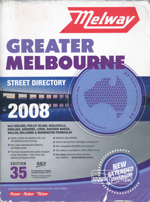
Book, Melway Greater Melbourne street directory 2008 : including Geelong, Phillip Island, Healesville, Kinglake, Gisborne, Lorne, Bacchus March, Wallan, Bellarine & Mornington Peninsulas; Edition 35, 2008, 2007
... routes information - train, tram, bus, walking and bicycle... routes information - train, tram, bus, walking and bicycle tracks ...Edition 35. 2008 Coloured detailed maps accessed by a street or location index. Cover: Totally revised and updated with over 730 additional street listings, new maps extending the Gisbourne and Wallan areas. The most comprehensive public transport routes information - train, tram, bus, walking and bicycle tracks. Eastlink fully detailed, Victoria Racing Club, Flemington enlargement, GPS compatible WGS/MGA Grid displayed, This editon is available in LARGE PRINT format, new eway electronic street directory now available - www.melway.com.au Special feature: New Hierachy of Roads Street directory, coloured maps, indexes, 1201 pagesstreets,roads,melbourne,map,melway -
 Kew Historical Society Inc
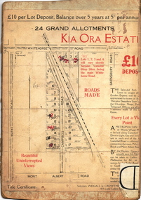
Plan - Subdivision Plan, Kia Ora Estate, 1930s
... the subdivision. The route of the Railway in this area is now a walking.... The route of the Railway in this area is now a walking/bike track ...Twenty-five grand allotments were offered for sale in the subdivision known as the Kia Ora Estate in Balwyn in the early 1930s. The streets identified in the subdivision include Whitehorse Road, Barnsbury Road, Campbell Road, Mont Albert Road and Burke Road. The lots were advertised for £10 deposit, with the balance to be paid over 5 years at 5 per cent per annum. The lots bordering Whitehorse Road were nominated as potential valuable shop sites, while the Mont Albert Road lots were advertised as having ‘wonderful views’. The Outer Circle Railway Line is shown traversing the subdivision. The route of the Railway in this area is now a walking/bike track bordered by strips of parkland.subdivision plans - balwyn, kia ora estate -
 Marysville & District Historical Society
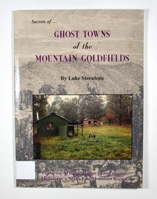
Book - Paperback book, Ghost Towns of the Mountain Goldfields, 1999
... ridden and pack, walking along a forest track on their way... depicting horses, both ridden and pack, walking along a forest track ...Ghost towns of the mountain goldfields in VictoriaPaperback. Cover has a drawing depicting horses, both ridden and pack, walking along a forest track on their way to a small town. There are heavily forested mountains in the distance. Overlaid onto the drawing is a modern photograph of an old stone building. In the foreground is a green timber building with a water tank and verandah. It is all set in the clearing in the middle of a forest.Stamp of the Marysville & District Historical Society Inc / P.O. Box 22 / Marysville 3779 Also the inscription: To Alma / Thanks for your help / Signature / LS / November 1999gold, gold mining, gold town, ghost town, victoria, australia, history -
 Bendigo Historical Society Inc.
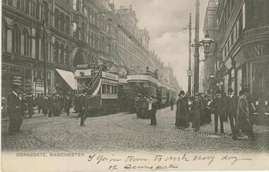
Postcard - GLADYS DEAN COLLECTION: POSTCARD, 1906 - 1908
... Manchester. Image depicts a street with trams, tram tracks, people... with trams, tram tracks, people walking and standing with buildings ...Printed black and white photographic postcard of Deansgate Manchester. Image depicts a street with trams, tram tracks, people walking and standing with buildings lining either side. There is a white 1cm border along the lower edge. The words Deansgate Manchester are printed in the border on the lower left hand side. The words 'A grim town to work everyday of Deansgate' are handwritten in the border. The reverse is blank.S Hildersheimer & Co Manchesterpostcard -
 Eltham District Historical Society Inc
Photograph - Digital Photograph, Alan King, Kinglake National Park, 27 March 2008
... the park’s extensive network of walking tracks amongst the protected... the park’s extensive network of walking tracks amongst the protected ...Fern gullies around Jehosaphat Gully Covered under National Estate. Published: Nillumbik Now and Then / Marguerite Marshall 2008; photographs Alan King with Marguerite Marshall.; p125 The magnificent Kinglake National Park, fringing Nillumbik’s north, is the largest national park close to Melbourne. Thanks to the vision and hard work of a band of local people, the park was created from what was rapidly becoming degraded land. Seeing a threat to Kinglake’s indigenous flora and fauna, several prominent local people campaigned for a national park, which was established in 1928.1 Since then, the park has grown through donations and acquisitions of land, from around 13,800 acres of land (5585ha) to 22,360 hectares. The Sugarloaf and Everard Blocks – of almost 8000 hectares – stand in Nillumbik and the park extends into Mitchell and Murrundindi Shires and the City of Whittlesea. Mt Everard commemorates William Hugh Everard, State member for Evelyn when the park was established. Before 1928, European settlers had degraded the Kinglake area, which was named after the celebrated English author and lawyer, Alexander William Kinglake. Remains of gold shafts and diggings in the park are reminders of Kinglake’s first settlers, who hoped to strike it rich at the gold diggings. But like other gold fields in this shire, they proved not very lucrative and soon timber cutting replaced mining in importance. However, before long, the accessible timber supply ran out, so in the 1920s agriculture took over – particularly potatoes and berry fruits – which involved large-scale clearing.2 The park’s instigator was retired Melbourne University Professor of Music, William Laver.3 As chair of the Kinglake Progress Association he began negotiations to have crown lands on the southern scarp of the Great Dividing Range reserved as a national park. Even before the park was proclaimed, from 1927, KPA members cut tracks to the major scenic points. Professor Laver was one of several people who gave land for the park, donating around 50 acres (20ha), including the Jehosaphat Gully.4 Laver chaired the park’s first Committee of Management, which raised money to employ a ranger and provide facilities, including tracks and roads for fire protection vehicles, toilets and shelters. The committee charged fees for firewood collection, some grazing of livestock, and visitor entrance, and obtained small State Government and Eltham Shire grants. In 1957 the State Government provided revenue for national parks. Then, in 1975, the State Government took over the management and the Committee of Management became an advisory committee, which disbanded in 1978. Originally, the park covered crown land in the Shires of Eltham and Whittlesea; then Wombelano Falls in Yea and other areas were added. In 1970 the park extended into the Shires of Eltham, Healesville, Whittlesea and Yea.5 Bush fires have been an ongoing problem. In 1939 hundreds of eucalypts and acacias had to be sown around the Jehosaphat Gully to rejuvenate the forest. To manage bushfires, the Committee of Management, then the State Government, worked closely with the Forestry Commission, shire councils and local fire brigades. Early national parks focussed on recreation. But by the 1980s, conservation, education and scientific research became more important, playing a vital role in preserving representative samples of the natural environment. Each year many thousands of people use the park’s extensive network of walking tracks amongst the protected plant and animal life as well as camping, cycling and horse riding. The park, along the slopes of the Great Dividing Range, has lookouts revealing magnificent views of the Melbourne skyline, Port Phillip Bay, the Yarra Valley and the You Yangs. Vegetation in the Masons Falls area includes messmate forest, Austral grass-trees, ferns and Hazel Pomaderris. In spring, orchids, lilies, everlasting daisies, correas, grevillea and heath appear. Around Jehosaphat Gully are wet and dry forest, fern gullies and banksia. Animal life includes wallabies, kangaroos, koalas, echidnas, possums, gliders and bandicoots. Male lyrebirds can be heard mimicking in the Jehosaphat Gully, particularly in the Everard Block in winter.This collection of almost 130 photos about places and people within the Shire of Nillumbik, an urban and rural municipality in Melbourne's north, contributes to an understanding of the history of the Shire. Published in 2008 immediately prior to the Black Saturday bushfires of February 7, 2009, it documents sites that were impacted, and in some cases destroyed by the fires. It includes photographs taken especially for the publication, creating a unique time capsule representing the Shire in the early 21st century. It remains the most recent comprehenesive publication devoted to the Shire's history connecting local residents to the past. nillumbik now and then (marshall-king) collection, kinglake national park, jehosaphat gully -
 Eltham District Historical Society Inc
Photograph - Digital Photograph, Alan King, Sign: Clara Southern, Heidelberg School Artists Trail, Main Road, Research, 2008
... and Wingrove Park, the Research walking track on Main Road... and Wingrove Park, the Research walking track on Main Road ...Warrandyte artist, Clara Southern, features on the Artists Trail. Published: Nillumbik Now and Then / Marguerite Marshall 2008; photographs Alan King with Marguerite Marshall.; p189 Since early in the 20th century this district has attracted artists and other creative people. So much so, that Eltham has been compared to the Left Bank in Paris, New York’s Greenwich Village and London’s Bloomsbury. That is until the 1970s when Eltham rapidly expanded into a suburb. However many artists still flourish not only in Montsalvat, Dunmoochin and the Bend of Islands but elsewhere in Nillumbik. Some artists who have worked or lived in Nillumbik are well-known nationally and internationally. Artists are attracted to the hilly district’s subtle colours, unique light and the Yarra River and Diamond Creek. The railway’s extension to Eltham in 1902 brought artists to paint for the day or to camp. Then many settled in Eltham, perhaps also because the poor quality land, far from the city, was cheap. Following World War Two they found they could build houses and studios cheaply by making their own mud-bricks. The flexible material, with its warm tones blending into the bush, also satisfied their aesthetic sensibilities. As early as 1900, Will Longstaff, known for his painting The Ghosts of Menin Gate at the National War Memorial in Canberra, lived at Stanhope in Peter Street, Eltham, later to become the home of intellectuals Clem and Nina Christensen. Members of Australia’s first significant art movement, the Heidelberg School of Artists, painted in Eltham, Warrandyte and Diamond Creek. Walter Withers lived at the corner of Bolton and Brougham Street, Eltham and taught Sir Hans Heysen, who for a short while stayed with the Withers family. In Warrandyte were Clara Southern, whom Frederick McCubbin taught at the National Gallery School and Penleigh Boyd, who is represented in all Australian state galleries and the National Collection in Canberra. May Vale, daughter of politician William, lived in Diamond Creek. With Jane Price they feature on the Heidelberg School Artists Trail, part of which runs through Nillumbik. The trail includes signs each displaying a reproduction of a painting by an artist and located near where the artist lived or painted. In Nillumbik the trail includes parts of Warrandyte, Eltham in the Alistair Knox Park, Main Road shopping precinct and Wingrove Park, the Research walking track on Main Road and the Diamond Creek Reserve. In 1916 artist William ‘Jock’ Frater lived at the corner of Arthur and Bible Streets, Eltham. Before then, Frater, with other artists including Percy Leason (who moved to Eltham in the mid 1920s) painted in Eltham on weekends. They camped near Bible and Pitt Streets and along the Diamond Creek where the Eltham Retirement Centre now stands.4 In 1921, painter Peter Newbury (father to painter David Newbury, who was born in Eltham) moved to Cromwell Street, Eltham. Max Meldrum, the first Australian painter to formulate a consistent theory of art largely based on tone,5 taught local artists Alan Martin, Clarice Beckett, Peter Glass and Justus Jörgensen. Meldrum visited Eltham then rented a house there for 18 months opposite Wingrove Park. In 1934, artist and architect Justus Jörgensen and his doctor wife Lil and friends built Montsalvat, the artists’ colony. Montsalvat has played an important part in attracting artists to Eltham and its mud-brick, pisé, stone and recycled building materials has had a major influence on Eltham’s built environment. Jörgensen’s students who also helped him build Monstalvat included Arthur Munday, Lesley Sinclair, Helen Lempriere, Joe Hannan, Helen, Sonia and jeweller/sculptor, Matcham Skipper. Among artists who visited Montsalvat were Clifton Pugh and Angry Penguins’ artists Albert Tucker and Arthur Boyd. Some who painted after World War Two were Alan Martin of Eltham and Warrandyte artists Frank Crozier and Harry De Hartog6, one of Melbourne’s first painters influenced by Cubism.This collection of almost 130 photos about places and people within the Shire of Nillumbik, an urban and rural municipality in Melbourne's north, contributes to an understanding of the history of the Shire. Published in 2008 immediately prior to the Black Saturday bushfires of February 7, 2009, it documents sites that were impacted, and in some cases destroyed by the fires. It includes photographs taken especially for the publication, creating a unique time capsule representing the Shire in the early 21st century. It remains the most recent comprehenesive publication devoted to the Shire's history connecting local residents to the past. nillumbik now and then (marshall-king) collection, clara southern, main road, research (vic), heidelberg school artists trail -
 Eltham District Historical Society Inc
Photograph - Digital Photograph, Alan King, Memorial to Peter Brock, Ferguson's Paddock, Hurstbridge, 23 January 2008
... included $100,000 towards the upgrade of a walking track... included $100,000 towards the upgrade of a walking track ...Ferguson’s Paddock, Hurstbridge. A plaque on a boulder commemorates Peter Brock. Published: Nillumbik Now and Then / Marguerite Marshall 2008; photographs Alan King with Marguerite Marshall.; p167 On a rock in Ferguson’s Paddock, Hurstbridge, a plaque commemorates Peter Brock. It includes the words: ‘Boy from Hurstbridge without special privileges, grew to become champion of racetracks around the world but he never forgot his beginnings’. Brock came from a well-established local family. Born in Hurstbridge in 1945, he lived in Anzac Avenue as a child, attended the Hurstbridge Primary and Eltham High Schools and lived in the district most of his life. His father Geoff owned the Diamond Valley Speed Shop in Greensborough. Brock’s forbears were amongst the area’s earliest settlers. From Scotland, the Brocks arrived in Tasmania in 1830, to graze sheep. Family members moved to Sunbury, then Preston, grazing sheep in the Bundoora area. John Brock owned Janefield, possibly named after his wife. In 1855 he granted around two acres (0.8ha) of his estate for a school.1 In 1866 Lewis Brock bought 264 acres (107ha) in Nutfield, the first non-Aboriginal person to own that land. They planted an orchard, then from around 1935, Brock’s uncle Sandy and his grandfather Lewis, ran a dairy on the property. In the 1980s Brock and his then partner Bev, bought most of the property, which they sold after their separation in 2006. Brock’s father was a Hurstbridge Football Club President, but Brock’s uncle Sandy, of Brocks Road, Doreen, has been particularly active in local affairs. He was President of the Mernda Football Club (then Plenty Rovers), President of the Panton Hill Football League and he founded the Arthurs Creek and District Landcare Group. He also gave more than 50 years of service to the Whittlesea Agricultural Society, the Volunteers for Australian Football and the Doreen Rural Fire Brigade. Community service was important to Brock too. Brock, with his then partner Bev, established the Peter Brock Foundation in 1997, the year he retired from full-time V8 Supercar racing. The Foundation’s grants have included $100,000 towards the upgrade of a walking track in the Hurstbridge Parklands and other projects include a holiday house for the families of child cancer victims. Brother Lewis saw Brock as a spiritual person, who had a great affinity with people. He saw Brock as a role model of someone who could achieve their dreams. ‘The family didn’t have much money, yet that didn’t stop Peter realising his dreams. He was strong and didn’t let difficult times crush him.’ Despite his later successes, Brock’s most treasured trophy was for running 100 yards (91.4m)at his primary school in 1955, and he appreciated his head master Ted Griffiths’ encouragement of his sporting endeavours. At high school Brock became captain of Everard House. In his first year he bought a 1928 Austin 7 for £5. He cut the car into a box shape with an axe and enjoyed driving it – despite it having no brakes - at his grandparents’ farm at Nutfield. The turning point in Brock’s life came at age 23, when he built an Austin A30 in an old henhouse in Wattle Glen, using a Holden engine. He was laughed at until it won the Australian Sports Sedan Championship in 1968. Brock’s career then took off and he became a professional driver. Brock won Australian motor sport’s best-known event, the Bathurst 1000, nine times. Brock endured a bitter split from Holden in 1986 over control of his Holden-backed vehicle modification business and a car performance-enhancing device he called the ‘energy polariser’– despite it having no scientific evidence to support its claims. But Brock returned to Holden in 1994. Then in 1997, aged 52, Brock retired from fulltime V8 Supercar racing. However he continued to race at motor sport events. Brock won several awards, including an Order of Australia Medal in 1980, the Australian Sports Medal in 2000, and the Centenary Medal. On September 8, 2006, Brock died; after his car hit a tree during the Targa West Rally in Western Australia.This collection of almost 130 photos about places and people within the Shire of Nillumbik, an urban and rural municipality in Melbourne's north, contributes to an understanding of the history of the Shire. Published in 2008 immediately prior to the Black Saturday bushfires of February 7, 2009, it documents sites that were impacted, and in some cases destroyed by the fires. It includes photographs taken especially for the publication, creating a unique time capsule representing the Shire in the early 21st century. It remains the most recent comprehenesive publication devoted to the Shire's history connecting local residents to the past. nillumbik now and then (marshall-king) collection, ferguson's paddock, hurstbridge, peter brock memorial, peter brock -
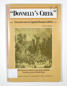 Marysville & District Historical Society
Book - Paperback book, Donnelly's Creek-From rush to ruin of a Gippsland Mountain Goldfield, 1990
... . They are walking along a forest track that has some tree stumps alongside.... They are walking along a forest track that has some tree stumps alongside ...A history of the Donnelly's Creek gold mine in VictoriaPaperback. Front cover has a drawing depicting two horses carrying packs followed by a man mounted on a horse. There is also two men on foot following with packs and walking poles. They are walking along a forest track that has some tree stumps alongside it.The back cover has two colour photographs. The top one is of an old wooden building with what appears to be an attached lean to. Both of the buildings have stone chimneys. There is a group of people sitting and standing outside the main building. The bottom photograph appears to be the ruins of a building and a fence. There are three people viewing the ruins.The captions accompanying the photographs are: History revisited - O'Sullivans Old Toombon Hotel Recreated and Remnants of a Bygone Mining Era.Stamp of the Marysville & District Historical Society Inc / P O Box 22 / Marysville 3779gold, gold miner, gold mining, gold field, gippsland, victoria, australia, history, fulton's creek, seaton, walhalla, aberfeldy, jericho, wood's point -
 Melbourne Tram Museum
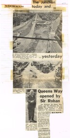
Newspaper, The Sun, The Herald, "The Junction today and Yesterday", "The Street that died" "Fare Rises attacked, Dec. 1968
... of the St Kilda Post Office walking across demolished track tracks... Office walking across demolished track tracks and wooden blocks ...Newspaper Clipping - set of four clippings adhered to two sides of two sheets of ruled quarto paper with punched holes on the left hand side - from newspaper about the St Kilda Junction tram and road works. 1 - "The Junction today and Yesterday", with photos of the St Kilda junction on 11/12/1968 and 1920, following the opening of Queens Way (road under the tram tracks_ by The Governor Sir Rohan Delacombe - from the Herald 11/12/1968. 2 - Keith Dunstan's a Place in The Sun about his visit to Brisbane and the closure of the Brisbane Tramway System - The Sun 11/12/1968 3 - "The Street that died" - the Sun 19/12/1968 - about the about the closure and removal of the tram tracks in Wellington St and its effect on the businesses. Has a photo of Frances Robinson of the St Kilda Post Office walking across demolished track tracks and wooden blocks. 4 - Trams - 20/12/1968 - about trams shunting at Malvern Depot 5 - two newspaper cuttings - "Fare Rises Attacked" - Monday 20-12-1968 - about proposed Fare Rises - quotes the Minister Mr Wilcox.trams, tramways, st kilda junction, opening, brisbane, road works, construction, malvern depot, wellington st, fares -
 Ballarat Tramway Museum
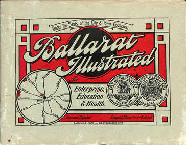
Book, "Ballarat Illustrated", 1972
... in photo, three ladies walking down the track. Page 37: Street... East, with tram track prominent in photo and how stone work ...Original c 1914 (see below), facsimile copy - re-published 1972. Original features photos of Ballarat City and Town, its buildings, parks and the various industries and organisations that were in Ballarat at the time of publication, including ESCo. Many photos features ESCo trams. Photos sepia toned. Has some red colour block printing on the front cover and rear, for Star Oil Engines. On inside back cover is a map with the places of interest and tram route map, marked in red. Pages are un-numbered. Original published by Ballarat East Town Council and Ballaarat City Council. On cover has number stamped in black in, "No. 87" (assume facsimile copy No.). Photos with publication show tram No. 21, built 1913 and ESCo photo page shows Mr. Pringle as Manager. Mr Pringle became manager in January 1911, As there is no photos of the "Avenue of Honour", or other mention of the first world war, assume original published about 1913 or 1914. Original shows Engravings and printing by "Campbell Wilson Prop Ltd, Ballarat". See Other Information as well for more listing details. High Resolution image added 31/8/2012 of i2 of ESCo page and i3 for Ballarat identies and sheet i4 extracted for Mr Pringle. PDF scan of full document added 21/5/2019 - see images btm633-1i.pdf and btm633-2i.pdf Notes on "Ballarat Illustrated" Reg. Item No. 733 From notes made by Neville Gower 12/1/1997 Cover: Inside front cover: Last paragraph, "Facilities for Travelling" - Electric trams serve all parts of Ballarat. Page 3: Street Scene, Municipal Town Hall, showing tram wiring Page 7: Street Scene, Lydiard St. North, intersection and tramway centre, with ESCo tram No. 21 in the bottom photo. Other photos features trams as well in Sturt St and Lydiard St. North. Page 9: Street Scene, Top photo of Sturt St. from Lydiard St. looking east, shows piles on right-hand side of road. Car parked by Post Office has a car registration number "9007". Bottom photo, an tram climbing hill, shows double trolley in the street, with early English type of pull offs. Page 13: Street Scenes and Historic Buildings: One of five photos, shows Victoria St. looking East, with tram track prominent in photo and how stone work was set up about the rails and overhead poles. Page 23: Street scene, Gardens North Entrance gates, shows details of gates near St. Aidans Drive. Note double trolley wire on poles, and style of insulators. No trams in photo, three ladies walking down the track. Page 37: Street Scene; Lydiard St views, top left hand photo, shows Railway station and railway gates with signal gantry and horse drawn vehicles. Tram tracks apparent. Bottom left hand photo shows Lydiard St. North, near Post Office, double track with centre poles - Single wire per track. Top right hand photo, showing Cemetery gates in background. Bottom right hand photo - from north end of Lydiard St. South, looking north, with an ESCo tram in background. Also has a parked car on left hand side. Page 45: Street Scenes - Bridge St; top photo at west end of Bridge St. with ESCo No. 11 with possibly double trolley wire in photo. Bottom photo at east end of Bridge St. with tram in background, shows junction. Double trolley heading out to Mt. Pleasant, single trolley for Victoria St. Page 45: Street Scenes - Bridge St; top photo at west end of Bridge St. with ESCo No. 11 with possibly double trolley wire in photo. Bottom photo at east end of Bridge St. with tram in background, shows junction. Double trolley heading out to Mt. Pleasant, single trolley for Victoria St. Page 61: Street Scenes and Historic Buildings - Public Institutions Ballarat - top left hand photo of the Hospital shows some tram track in foreground, with double trolley wire. Top right photo is of the Orphanage, the name of the tram terminus for many years. Page 68: Electric Supply Co. of Victoria's pages - top photo showing powerhouse in background, across the lake, can hardly see anything for the trees, except for the chimney. Bottom photos of the steam Turbo Generators and the switchboard. Gives Mr. P.J. Pringle as Chief Engineer and General Manager. He took over in Jan. 1911. Page 69: Ballarat East Views - features photo of Black Hill open cut, Ballarat East Railway Station, Ballarat Fire Station and "Victoria St. looking East", repeat of photo printed on page 12, but slightly darker. Image on system includes fire station and railway station, - Ballarat East. Page 78: Series of photos of various Ballarat VIP's of the era, fourth one in on top line features "P.J.Pringle, Electric Supply Co." Inside Back cover - map of Ballarat including tram lines and places of interest marked in red. Gives a detailed photographic presentation of Ballarat in 1914.80 page book with, in addition, light green card covers, titled "Ballarat Illustrated". Loose copy of page 9 and 10 held.trams, tramways, ballarat, local history, heritage buildings, esco -
 Kiewa Valley Historical Society
Photo - Bogong Township, September 1953
In 1940 Field Headquarters for the Kiewa Scheme were established at Bogong with office, workshop facilities and accommodation for workmen, staff and some families constructed. (There had been a 'tent camp' on this site in 1939 but was destroyed by bushfires) Construction of accommodation continued until 1947. A total of 40 houses plus a hostel for single staff, post office, police station, medical centre and primary school all with water and sewerage and electricity supply. The staff hostel was known as Kiewa House and is now occupied by the Education Department. Lake Guy was named after Mr. L.T. Guy who was the Resident Engineer in charge of construction work and associated activities on the Kiewa area. He held this position from 1939 to November 1946 when he was transferred to Head Office. The Bogong Township was developed firstly as an accommodation centre (base camp) for construction workers employed under the Kiewa Hydroelectric Scheme. Due to the influx of European workers into the Township the beautification of the immediate surrounds (gardens etc.) had a distinct European flavour. This environment has been very beneficial for tourism in later years. At the completion of the scheme, in the 1960's, the village was opened to public/tourism use. Strict environmental control has not allowed for any extensive redevelopment in tourist accommodation and basically restricted it to the accommodation initially built for the construction workers. Activities such a bike riding, snow skiing, restricted horse riding and bush walking on the Alpine plains and mountains are now a viable part of the Kiewa Valley Tourist Industry. The lake is one of the many water storage reservoirs used to supply the power stations their main power to run the huge turbines generating the final product, electricityBlack and white photograph of Bogong Township taken from Little Arthur fire track. September 1953Faded handwritten inscription on back - Bogong Township taken from Little Arthur fire track. Sept 1953bogong village, secv -
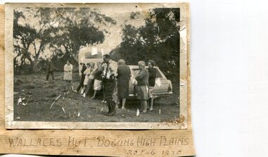 Kiewa Valley Historical Society
Photographs x 2- Bus tour of Wallaces Hut, 20/02/1970
Wallace's hut was built in 1889 and is probably the oldest surviving hut on the high plains of north-east Victoria. It was built in six weeks by Irish immigrant brothers Arthur, William and Stewart Wallace among old snow gums on a grassy plain above the snowline. The brothers held grazing leases on the High Plains and the hut was built to provide shelter for the cattlemen working there. It is probably the oldest hut on the Victorian high plains. It is part of the early history of hydroelectricity in the state and has links with early SEC meteorological data recording in the area Apart from its historical significance, Wallace’s Hut is a popular stop for tourists and photographers and is the starting point for the Wallace’s Heritage trail, which is a popular and well used hiking track, by locals and visitors alike.2 black and white photographs mounted on buff card. Photos taken during a bus trip to Wallace's Hut on Feb. 20, 1970 1. Group of local Kiewa Valley residents on a bus tour to Wallace's hut 2. Group of adults and children pictured outside Wallace's hut1. Handwritten in black ink on bottom of photo 'Wallace's Hut, Bogong High Plains, 20 Feb, 1970 2. No markingswallace's hut, bogong high plains, bush walking, cattlemen -
 Kiewa Valley Historical Society
Papers - Edmondson's Hut, The letter is dated 8th October 1974
Edmondson's Hut is a cattleman's hut on the Bogong High Plains. Jim Edmondson obtained Run 33 (near Mt Nelse) in the early 1930s. He pre cut the timber at his property in Tawonga and along with iron for the walls, chimney and roof took it up to the Bogong High Plains on pack horse. The hut's wall and ceiling were lined and the hut had a 'fairly good floor and bunks'. In 1971 the hut was donated to the Education Department and was approved for transfer by the Lands Department in 1974. Bogong Outdoor School camp has been using the hut for students to camp in as well as National Fitness parties when walking in the area. The upper Kiewa Valley was settled from the mid 1860s and from its earliest days cattle were taken on to the Bogong High Plains to graze during summer. Jim Edmondson took his cattle from the Kiewa Valley to Mt Fainter and later to Run 33, near Mt Nelse. His hut is significant in the history of Cattlemen's huts on the Bogong High Plains.Four A4 typed sheets on white paper - 1. Acknowledgement of transfer of Edmondson's Hut. 2. History of Visitors (to the hut) Prior to 1971. 3. Two poems. 4. One poem 1. Emblem of Education Dept. Centre top of page. Addressed to James Edmondson, Tawonga, Victoria. 2. Page headed History and Visitors prior 1971. 3. My Old black Poley Cow (and) Roper's Track. 4. So Long, Mates!education department. edmondson's hut. bogong high plains. cattlemen. poetry. cattleman hut. bush walking. -
 Kiewa Valley Historical Society
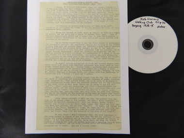
Diary Extract - Trip to Bogong High Plains Xmas 1934 & DVD photos, original diary 1934
The Melbourne Women's Walking Club enjoyed bush walking as a hobby travelling to the north east of Victoria, using pack horses and camping on a 9 day hike. One of the woman, 'Bill' describes each day in detail - what they did, where they went and what they saw giving an insight into walking and the Bogong High Plains in the mid 1930's before the Kiewa Hydro Electric Scheme opened up the area. The diary mentions a photo being taken by Mr Blackwell on the 9th day, New Year's Eve 'from a lovely bush track from which, looking back at intervals we got our final glimpse of Fainter. 5 miles from from our destination'.Historic: This extract from the diary of 'Bill', a member of the Melbourne Women's Walking Club gives an insight into walking in the mid 1930's and describes the Bogong High Plains as it was then before it was opened up with a road built during the Kiewa Hydro Electric Scheme. It describes the area in summer including the flora & fauna, cattle grazing & cattlemen, the huts, the gauges set up by the State Electricity Commission of Victoria, the people working up there, the weather and the lifestyle of the walking group - their food, duties, swimming etc.. Six double sided typed photocopied yellow pages describing the Melbourne Women's Walking Club trip to the Bogong High Plains at Christmas in 1934. Also one page photocopied of the programme for Year 1934-35 with an arrow pointing to the above trip and a page with a photocopied sepia photo of the "Melbourne Women's Walking Club / Bogong High Plains / Dec. 1934. DVD 12 photos of the trip arrow showing trip from Programme. Title of photo "Melbourne Women's Walking Club / Bogong High Plains / Dec. 1934melbourne women's walking club. bogong high plains. camping. pack horses. cattlemen's huts. -
 Kiewa Valley Historical Society
Map - Topographical, Ski Club of Victoria Bogong High Plains and Adjacent Peaks, Early 1930's
This map has been in the Ryder family for approx. 70 years. Probably used when bush walking and skiing in the early days on the Bogong High Plains. The Ryder family are farmers in the Kiewa Valley and were involved in taking their cattle up to the Bogong High Plains where they had a lease. The State Electricity Commission of Victoria constructed the Kiewa Hydro Electric Scheme opening up the area during the 1940's and 1950's. This type of map is an early one, used by people in the Kiewa Valley and possibly by surveyors prior to construction.The map is an early topographic map used by farmers living in the Kiewa Valley. It is historically significant as these people were involved in taking cattle up to the High Plains during summer and may have been used for bush walking and skiing.This is a sepia coloured paper map which was originally printed copyright registered. It was revised in 20/6.33/4.4.37/8.4.40/24.8.43/19/6/54. It shows roads / tracks / snow poles / snow pole numbers (27) / Snow pole spacing (3 chains. 66 yards) approximately 27 poles to the mile / height above sea level in feet - 5280. Water courses not definitely located etc.Rocky Valley Dam (Kiewa Hydro Electric Scheme) has been drawn on the map by hand with a biro. There is a wooden rod at the top of the map.topographic map; kiewa valley; ryder family; high plains of victoria -
 Warrnambool and District Historical Society Inc.
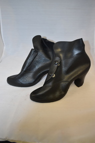
Household, Pair of Over-Shoes, 1940s
These over shoes or galoshes would have been worn by a woman wishing to protect the high-heel shoes she was wearing at the time. They would have been used in wintry weather or when walking over rough and wet country roads or tracks, perhaps when going dancing or to a function of some sort. With the advent of common car use and better roads, this type of over-shoe would no longer be used today.These shoes are of interest as examples of the footwear worn by women in the mid 20th century to protect lighter and more fragile shoes. This is a pair of black rubber over-shoes or galoshes for wearing over high-heeled shoes. They have moulded rubber soles with high heels, rubber uppers with a flap to cover the ankles and an opening with two metal press studs with black button tops. The inside is lined with light brown cloth. ‘Dunlop’ ‘DZM’ ‘LZA’ women’s fashions, history of warrnambool -
 Eltham District Historical Society Inc
Folder, Commercial Bank of Australia Eltham Branch Hold-Up, 15 December 1949
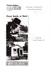
Thursday, December 15, 1949, the quiet little bank was embroiled in an infamous wild shoot-out between a daring thief and two bank officers. Today, the building still carries the scars ; a bullet hole remains visible in a cedar bench testifying to the events that played out that day. 3.30 a.m., Friday, December 9. The manager of the Commercial Bank branch at Greensborough, Mr Harry Wallace and his wife are asleep in their bedroom of the little house behind the branch. Harry is awakened by a noise and sees an intruder in a corner of the bedroom. He calls out but the intruder who has switched off the power in anticipation flees through a side door and scarpers down Main Street. Harry summons the police but a search by First Constable Thomas of the Greensborough Police assisted by a wireless patrol car is unsuccessful. A report is filed noting the theft of a .25 calibre pistol from the wardrobe. Thursday, December 15th. It is 1pm and the Commercial Bank has just opened. The branch is only open Mondays and Thursdays from 1-3pm. The morning started off a little cool with some scattered showers but it has fined up and the temperature is now around 61 degrees (16 C). A new grey Singer sports car with soft-top pulls up on the opposite side of the road and a young man, neatly dressed in a dark blue suit, wearing a grey hat and carrying a brief case exits the vehicle. He looks around then crosses the road and walks up the steps and through the door into the bank. There are three people inside; Mr. Jack Burgoyne whose grocery store is situated just 50 yards up the road, Mr. Lindsay A. Spears, the Eltham Agency Receiving Officer and by chance, Mr Harry Wallace, manager of the Greensborough branch. Jack Burgoyne takes note of the young stranger; thinking to himself he appears nervous. The man approaches the counter and introduces himself as John Henderson of Greensborough and explains that he wishes to open a new account. He places his hat and £3 on the counter. Mr Spears attends to the paperwork. He asks the young man to sign two forms, which he does but then he withdraws from the counter and starts walking towards the door. Suddenly he spins around pulling an automatic pistol from his right-hand pocket. He exclaims forcefully; “The game’s on! I’ll take the lot!” Spears appears to comply by pretending to open a drawer. The man shouts loudly, “Keep your hand away from that drawer.” Spears instead reaches for a pistol in his pocket and challenges the man, “Here it is. Come and get it!” At the same time, Harry Wallace pulls a pistol from his pocket as well. The bandit fires a shot but misses, the bullet striking the counter. Both Spears and Wallace open fire and Jack Burgoyne ducks for cover. As the bandit turns and runs for the door leaving his £3 behind, he fires another shot, which strikes the ceiling. Spears fires back, and thinks he may have hit him in the foot. The bandit flees the bank and heads for the grey Singer car, registration NO-106, parked opposite. Wallace and Spears pursue him to the door and open fire again, striking the car three times around the driver’s door. Spears lets off eight shots and Wallace, seven before his gun jams. The getaway car initially heads slowly down Main Road towards Bridge Street. About 100 yards down the road, Dave Adams, a PMG employee, who has heard the shots, throws a steel manhole step at the driver. It hits the roof of the car nine inches above the driver’s head and tears the hood. Another witness claims to have seen the door blow open and the driver raise his hand. The car gathers speed and swings left into Bridge Street racing along at about 60 miles an hour careering recklessly past council employee, Mr. Percy Williams, who is driving a dray along Smarts Road [believed to be Bridge Street]. At the end of the road the Singer fails to get round the sharp turn and crashes into an embankment skidding to a stop outside the home of Mr John Clifford. One side of the car is wrecked. Mr Clifford, an aircraft engineer hears the fast travelling car bump heavily into the road bank at about 1.25 p.m. Hearing the whine of an engine he goes outside to find the grey Singer parked at the side of the road. Jack George also lives at the corner and hears the car crash. “The bandit opened the car door, ran 50 yards, and suddenly turned back,” exclaims Jack. “He took something from the car. It might have been a gun.” In his haste, the bandit drops his grey felt hat, size 6 7/8, on the road and dashes up Sherbourne Road for about 200 yards then disappears into the scrub carrying a brief case and a bundle in which a sailor’s cap can be seen. About 3 p.m., Mr H.D. Pettie of Mountain View Road, Montmorency is looking through his field glasses and notices a young man walking through thick scrub on private property some distance from his house. The man is wearing a sailor’s cap and disappears along the railway track toward Montmorency. As the day progresses, ten police cars, one motor cycle, and about 40 police led by Det. Sgt. McMennemin of Malvern CIB are searching for him. They believe he is hiding in thick scrub along the bank of the creek about half-a-mile outside Eltham township. Wireless patrol cars, four mobile traffic cars and the CIB area cars from Malvern and Kew are taking part. Police check the thief’s car and discover it was stolen from Helen Baxter, of Doncaster Road, North Balwyn from outside Victoria Barracks. Harry Wallace informs the police that he believes he recognised the bandit as the man who took his pistol from his bedroom the previous Friday morning. As night falls, armed police are posted at strategic points in the Eltham-Greensborough district. Police in cars are watching the roads. Others are searching the bush and checking passengers on trains. Little do they realise the young man has already slipped out of the net. SEQUEL YOUTH OF 19 CHARGED WITH ATTEMPTED ARMED ROBBERY OF BANK AT ELTHAM Weekly Times, Wednesday 15 February 1950, page 6 Detectives who raided a house in Bell St., Coburg, Melbourne, charged a 19-year-old youth, of South Yarra, with attempted armed robbery at the Commercial Bank’s Eltham (Vic.) receiving depot on Dec. 15. Police say they recovered a loaded automatic pistol, diamond and signet rings worth more than £200, a complete set of house-breaking instruments, a sailor’s uniform, and chloroform gauze in the raid. The youth was charged that while armed with an offensive weapon, he attempted to rob Lindsay George Spears of a sum of money. He was further charged on six counts of breaking, entering and stealing. Police allege that the person who tried to hold up Mr Spears in the Commercial Bank receiving depot at Eltham on December 15. escaped in a stolen car, after Mr Spears and Mr Henry Wallace, manager of the bank’s Greensborough branch, had fired at him. After the car crashed, he escaped into thick scrub and is alleged to have changed into a sailor’s uniform. On December 9 an automatic pistol was stolen from Mr Wallace’s bedroom at the Greensborough bank. The chloroform pad recovered is alleged to have been stolen from the Dental Supply Company, Plenty Road, Preston. The rings are alleged to have been taken in a £513 burglary from the shop of James Paton. Sydney Road, Coburg. Det. Sgt. H. McMennemin conducted the investigations with Senior Dets. R. Newton and M Downie, Detectives l. Dent, R. Rayner, P. Pedersen and M. Handley and First Constable A. Thomas. The youth will appear at Eltham Court on February 22. Manager’s Gun Used in Holdup at Bank The Age, Thursday 23 February 1950, page 4 It was stated in Eltham court yesterday that a youth who robbed a bank manager of his pistol, later used it in an attempt to hold-up the bank. Kay Arthur Morgan, 19, draftsman, of Castle-street, South Yarra, was committed for trial on charges of breaking and entering, and stealing a pistol and attempted robbery while armed with an offensive weapon. He pleaded guilty. The manager of Eltham branch of the Commercial Bank of Australia Ltd., Henry Clifton Cabot Wallace, said he disturbed someone in the bedroom, in which he and his wife were sleeping, at 3 a.m. on December. 9, 1949. Later he found that his automatic- pistol was missing. On December 15 a youth, who said his name was John Henderson, entered the bank and opened a new account. As the youth was leaving the bank he turned round with a pistol in his hand and said: — “I want the lot.” Spear indicated a drawer under the counter; and said.— “Here it is. Come and get it.” The youth said:— “Keep your hand away from that drawer.” Witness said Spear then drew his pistol from his hip pocket. The youth fired at them, and Spear returned the fire. “I pulled my pistol and fired, too” said witness. The youth fired again, ran out to a car and drove off. Witness and Spear fired several shots at the car. The youth was the accused Morgan, sitting in court, witness said. Evidence was given that one bullet was found in the celling and the other in the bank. Morgan was allowed £100 bail on each charge. Morgan ended up serving three years for the failed armed robbery and became a notorious criminal. He had twin sons, Peter and Doug and even though only ten years old, Morgan would get his sons to act as lookouts whilst he committed burglaries. The lads became building contractors but when the industry suffered a downturn in 1977 and they were short on cash, they returned to the family business. Over the following 23 months they undertook 24 raids on country and outer-suburban TABs and banks. Whilst robbing one country bank for the third time, just like their father, it all went wrong ending up with a police officer shot. They were nick-named the “After-dark” bandits and are considered to be Australia’s last bushrangers. They were convicted and served 17 years in prison.5 x A4 photocopied pagesbank hold-up, cba bank, det sgt mcmennemin, eltham, h.d. pettie, harry wallace, jack burgoyne, kay arthur morgan, lindsay a. spears, main road -
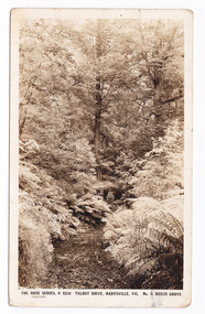 Marysville & District Historical Society
Postcard (item) - Black and white postcard, Rose Stereograph Company, Talbot Drive, Marysville, Vic. No. 5. Beech Grove, 1913-1967
... and Mountain Ash woodland and is one of the many walking tracks ...A postcard in a series produced by the Rose Stereograph Company in Victoria, Australia as a souvenir of Marysville.A black and white photograph taken along Lady Talbot Drive, Marysville, Victoria, of the area known as the Beech Grove. The Beeches Rainforest Walk is a loop that starts at Taggerty Cascades before winding through Myrtle Beech and Mountain Ash woodland and is one of the many walking tracks in and around Marysville. It is accessible from Lady Talbot Drive which is a 24 kilometer scenic rainforest car journey which passes a number of walks and waterfalls in the Yarra Ranges National Park. Lady Talbot Drive is named after Lady Sarah Elizabeth, the wife of Sir Reginald Talbot, who was the Governor of Victoria from 25th April, 1904 to 6th July 1908. This postcard was produced by the Rose Stereograph Company as a souvenir of Marysville.POST CARD The "Rose" Set/ De Luxe A Real Photograph/ Produced in Australia Published by the Rose Stereograph Co./ Armadale, Victoria. This is just to remind you of/ Marysville - I am spending the/ weekend up here & thoroughly/ enjoying it./ Love to all of you L. McIver All best honey + thanks for/ a lovely day E. + P. F.talbot drive, marysville, victoria, beech grove, p. 2310, rose series postcard, postcard, souvenir, beeches rainforest walk, sarah elizabeth talbot, sir reginald talbot, mountain ash, myrtle beech -
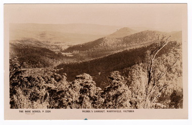 Marysville & District Historical Society
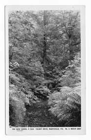
Postcard (item) - Black and white postcard, Rose Stereograph Company, Nichol's Lookout, Marysville, Victoria, 1913-1967
A postcard in a series produced by the Rose Stereograph Company in Victoria, Australia as a souvenir of Marysville.A black and white photograph of the view of the surrounding hills from Nichol's Lookout which is on the Marysville-Wood's Point road near Marysville in Victoria. The Marysville-Woods Point Road was originally part of the Yarra Track, constructed in the early 1860s to provide access between Healesville and the Woods Point Goldfields. Despite the steep terrain and engineering difficulties, the Yarra Track soon became a busy route used by pack horses, horse-drawn drays, and wagons. Today this sealed mountain road is a popular scenic drive between Marysville and Warburton.POST CARD The "Rose" Series/ De Luxe A Real Photograph/ Produced in Australia Published by the Rose Stereograph Co.,/ Armadale, Victoria. "The Falls"/ Marysville/ Monday Dear Mrs Wilson. Just a line to let you know/ I'm here by Dr's advice. He advised me/ to get extended leave. I'm suffering from/ blood pressure so have to go slow-no/ walking-Ugh-a bitter pill to swallow/ in these glorious surroundings. However/ I'm feeling much better and hope on my/ return (Saturday) to be able to resume duty/ I trust you and yours are well, Your loving/ friend A Butler. Quite/ an imposing/ hotel now/ stands at/ Keppel's/ Corner./ A.B.nicol's lookout, lookout, marysville, victoria, p. 2324, rose series postcard, postcard, souvenir, yarra track, mining, wood's point -
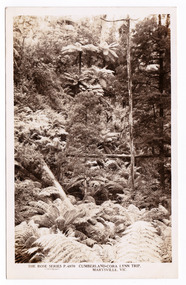 Marysville & District Historical Society
Postcard (item) - Black and white postcard, Rose Stereograph Company, Cumberland-Cora Lynn Trip, Marysville, Vic, 1913-1967
... walking track... cora lynn falls marysville victoria walking track p. 4970 rose ...A postcard in a series produced by the Rose Stereograph Company in Victoria, Australia as a souvenir of Marysville.A black and white photograph of a view up a gully in the Cumberland Valley in Victoria. The Cumberland Valley is home to both the Cumberland and Cora-Lynn Falls. It is also home to the Big Tree, a huge Mountain Ash tree which, at one time, was the tallest hardwood tree in the world. The Cumberland Valley is a short drive from Marysville.POST CARD The "Rose" Series/ De Luxe A Real Photograph/ Produced in Australia Published by the Rose Stereograph Co.,/ Armadale, Victoria.cumberland valley, cora lynn falls, marysville, victoria, walking track, p. 4970, rose series postcard, postcard, souvenir, cumberland falls, the big tree, mountain ash -
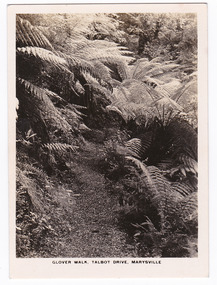 Marysville & District Historical Society
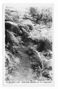
Photograph (item) - Black and white photograph, Rose Stereograph Company, Glover Walk, Talbot Drive, Marysville, 1913-1967
... government to fund walking tracks in the district, one of which ...An early black and white photograph of Glover Walk which was off Lady Talbot Drive in Marysville, Victoria.An early black and white photograph of Glover Walk which was off Lady Talbot Drive in Marysville, Victoria. Glover Walk was named after Hannah Elizabeth Glover, a nurse who in 1908 established the Kerami guest house in Marysville. She became an active member of the local tourist association and was acclaimed for her 'energy and enterprise' (Riverine Herald, 31 December 1915). In this capacity she successfully lobbied government to fund walking tracks in the district, one of which was given her name. The photograph was also used to produce the Rose Series postcard P. 2312.marysville, victoria, photograph, glover walk, hannah elizabeth glover, lady talbot drive, talbot drive, p. 2312, rose stereograph company, souvenir, rose series postcard, marysville tourist association, kerami guest house -
 Marysville & District Historical Society
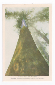
Postcard (item) - Colour postcard, Nucolorvue Productions Pty. Ltd, THE BIG TREE. 301 FT HIGH. HIGHEST KNOWN HARDWOOD TREE IN THE WORLD, 1950's
... . There is a walking track through the forest that will take you to the Big ...A colour photograph of the Big Tree in Cambarville near Marysville in Victoria.A colour photograph of the Big Tree in Cambarville near Marysville in Victoria. It was, at one stage, known to be the tallest hardwood tree in the world standing at 92 meters (301ft, 6 inches). However, it was reduced to 84 meters by a wind storm in 1959. It is a mountain ash. There is a walking track through the forest that will take you to the Big Tree. This postcard was produced by Nucolorvue Productions as a souvenir of Marysville.POST CARD NUCOLORVUE PRODUCTIONS, ELWOOD, VICTORIAmarysville, cambarville, the big tree, hardwood, forest, nucoloruve productions, postcard, souvenir -
 Marysville & District Historical Society
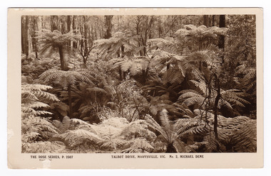
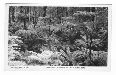
Postcard (item) - Black and white postcard, Rose Stereograph Company, Talbot Drive, Marysville, Vic. No. 2, Michael Dene, 1913-1967
... walking track.... marysville victoria michael dene michael dene track p. 2307 walking ...A postcard in a series produced by the Rose Stereograph Company in Victoria, Australia as a souvenir of Marysville.A black and white photograph showing trees and tree ferns, taken along the Michaeldene Trail near Lady Talbot Drive in Marysville in Victoria. The Michaeldene Trail is a level two loop that leads to the Taggerty River Lookout and may be undertaken as either as a Short (2.7 km) Loop, or a Long (4.3 km) Loop - 30 minutes to one hour and a half. The attractive bushland linking the Steavenson and Taggerty Rivers allows walkers and cyclists to step back in time to Marysville’s historic logging past. Sections of this mostly flat circuit follow old tramline alignments, which in places reveal the original timber sleepers on which the big logs were transported to the nearby sawmill.The Taggerty River Lookout offers views over the Taggerty River. The Trestle Bridge was built to span a small gully and provide access to the timber on Red Hill. Lady Talbot Drive is a 24 kilometer scenic rainforest car journey which passes a number of walks and waterfalls in the Yarra Ranges National Park. Lady Talbot Drive is named after Lady Sarah Elizabeth, the wife of Sir Reginald Talbot, who was the Governor of Victoria from 25th April, 1904 to 6th July 1908. This postcard was produced by the Rose Stereograph Company as a souvenir of Marysville.REAL PHOTO POST CARD THE "ROSE"SERIES DE LUXE PRODUCED IN AUSTRALIA Published by "The Rose Stereographs" Armadale, Victoria.marysville, victoria, michael dene, michael dene track, p. 2307, walking track, rose series postcard, postcard, souvenir, lady talbot drive, sarah elizabeth talbot, sir reginald talbot -
 Marysville & District Historical Society
Postcard (item) - Black and white postcard, Rose Stereograph Company, Talbot Drive, Marysville, Vic. No. 2, Michael Dene, 1913-1967
... walking track... dene michael dene track p. 2307 walking track rose series ...A postcard in a series produced by the Rose Stereograph Company in Victoria, Australia as a souvenir of Marysville.A black and white photograph showing trees and tree ferns, taken along the Michaeldene Trail near Lady Talbot Drive in Marysville in Victoria. The Michaeldene Trail is a level two loop that leads to the Taggerty River Lookout and may be undertaken as either as a Short (2.7 km) Loop, or a Long (4.3 km) Loop - 30 minutes to one hour and a half. The attractive bushland linking the Steavenson and Taggerty Rivers allows walkers and cyclists to step back in time to Marysville’s historic logging past. Sections of this mostly flat circuit follow old tramline alignments, which in places reveal the original timber sleepers on which the big logs were transported to the nearby sawmill.The Taggerty River Lookout offers views over the Taggerty River. The Trestle Bridge was built to span a small gully and provide access to the timber on Red Hill. Lady Talbot Drive is a 24 kilometer scenic rainforest car journey which passes a number of walks and waterfalls in the Yarra Ranges National Park. Lady Talbot Drive is named after Lady Sarah Elizabeth, the wife of Sir Reginald Talbot, who was the Governor of Victoria from 25th April, 1904 to 6th July 1908.REAL PHOTO POST CARD THE "ROSE"SERIES DE LUXE PRODUCED IN AUSTRALIA Published by the Rose Stereographs Armadale, Victoria. Tomorrow is your Official day/ I believe. So Very Very many happy/ returns, & best of luck & good/ wishes from/ your May I rec'd this on/ 1st. (illegible)/ thought it a good snap of our ferns.marysville, victoria, michael dene, michael dene track, p. 2307, walking track, rose series postcard, postcard, souvenir, lady talbot drive, sarah elizabeth talbot, sir reginald talbot -
 Marysville & District Historical Society
Postcard (item) - Black and white postcard, Rose Stereograph Company, Talbot Drive, Marysville, Vic. No. 5, Beech Grov, 1913-1967
... and Mountain Ash woodland and is one of the many walking tracks ...A postcard in a series produced by the Rose Stereograph Company in Victoria, Australia as a souvenir of Marysville.A black and white photograph taken along Lady Talbot Drive, Marysville, Victoria, of the area known as the Beech Grove. The Beeches Rainforest Walk is a loop that starts at Taggerty Cascades before winding through Myrtle Beech and Mountain Ash woodland and is one of the many walking tracks in and around Marysville. It is accessible from Lady Talbot Drive which is a 24 kilometer scenic rainforest car journey which passes a number of walks and waterfalls in the Yarra Ranges National Park. Lady Talbot Drive is named after Lady Sarah Elizabeth, the wife of Sir Reginald Talbot, who was the Governor of Victoria from 25th April, 1904 to 6th July 1908. This postcard was produced by the Rose Stereograph Company as a souvenir of Marysville.POST CARD The "Rose" Series/De Luxe A Real Photograph/ Produced in Australia Published by the Rose Stereograph Co./ Armadale, Victoria. MATHESONtalbot drive, marysville, victoria, beech grove, p. 2310, rose series postcard, postcard, souvenir, beeches rainforest walk, sarah elizabeth talbot, sir reginald talbot, mountain ash, myrtle beech -
 Marysville & District Historical Society
Postcard (item) - Black and white postcard, Rose Stereograph Company, Talbot Drive, Marysville, Vic. No. 7, Glover Walk, 1913-1967
... successfully lobbied government to fund walking tracks in the district ...A postcard in a series produced by the Rose Stereograph Company in Victoria, Australia as a souvenir of Marysville.An early black and white photograph of Glover Walk which was off Lady Talbot Drive in Marysville, Victoria. Glover Walk was named after Hannah Elizabeth Glover, a nurse who in 1908 established the Kerami guest house in Marysville. She became an active member of the local tourist association and was acclaimed for her 'energy and enterprise' (Riverine Herald, 31 December 1915). In this capacity she successfully lobbied government to fund walking tracks in the district, one of which was given her name. This postcard was produced by the Rose Stereograph Company as a souvenir of Marysville.POST CARD The "Rose" Series/ De Luxe A Real Photograph/ Produced in Australia Published by the Rose Stereograph Co.,/ Armadale, Victoria.marysville, victoria, photograph, glover walk, hannah elizabeth glover, lady talbot drive, talbot drive, p. 2312, rose stereograph company, souvenir, rose series postcard, marysville tourist association, kerami guest house -
 Marysville & District Historical Society
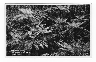
Postcard (item) - Black and white postcard, Valentine Publishing Co. Pty. Ltd, Beautiful Ferns, on Michaeldene Track, Marysville. V.25, 1923-1963
... walking track.... This walking track links the Steavenson River and the Taggerty Rivers ...An early black and white photograph of tree ferns along the Michaeldene Track in Marysville in Victoria.An early black and white photograph of tree ferns along the Michaeldene Track in Marysville in Victoria. This walking track links the Steavenson River and the Taggerty Rivers and is a step back in time to Marysville's historic logging past. Sections of this mostly flat circuit follow old tramline alignments, which in places reveal the original timber sleepers on which the big logs were transported to the nearby sawmill. This postcard was produced by the Valentine Publishing Co as a souvenir of Marysville.VALENTINE'S POST CARD A GENUINE PHOTOGRAPHmichaeldene track, walking track, marysville, victoria, tree fern, steavenson river, taggerty river, logging -
 Marysville & District Historical Society
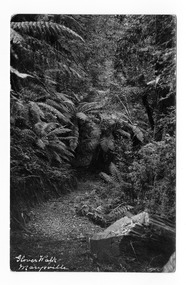
Postcard (item) - Black and white postcard, Glover Walk Marysville, Unknown
... government to fund walking tracks in the district, one of which ...An early black and white photograph of Glover Walk which was off Lady Talbot Drive in Marysville, Victoria.An early black and white photograph of Glover Walk which was off Lady Talbot Drive in Marysville, Victoria. Glover Walk was named after Hannah Elizabeth Glover, a nurse who in 1908 established the Kerami guest house in Marysville. She became an active member of the local tourist association and was acclaimed for her 'energy and enterprise' (Riverine Herald, 31 December 1915). In this capacity she successfully lobbied government to fund walking tracks in the district, one of which was given her name.POST CARD PLACE/ POSTAGE/ STAMP/ HERE Marysville/ Dear Kath/ We managed to get here safely/ after a lovely trip, but it/ has done nothing but rain/ since we arrived. It looks/ as if it is going to clear up/ a bit & perhaps we will/ be able to get a few fish. Being over in this spot I/ am unable to send you/ the weekly suply of ??????/ so please sweetheart let me/ off this time. I hope to/ see you all again soon./ Love + kisses from your Valmarysville, victoria, glover walk, hannah elizabeth glover, lady talbot drive, talbot drive, souvenir, marysville tourist association, kerami guest house, postcard -
 Marysville & District Historical Society
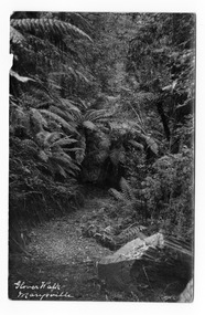
Postcard (item) - Black and white postcard, Glover Walk Marysville, Unknown
... government to fund walking tracks in the district, one of which ...An early black and white photograph of Glover Walk which was off Lady Talbot Drive in Marysville, Victoria.An early black and white photograph of Glover Walk which was off Lady Talbot Drive in Marysville, Victoria. Glover Walk was named after Hannah Elizabeth Glover, a nurse who in 1908 established the Kerami guest house in Marysville. She became an active member of the local tourist association and was acclaimed for her 'energy and enterprise' (Riverine Herald, 31 December 1915). In this capacity she successfully lobbied government to fund walking tracks in the district, one of which was given her name.POST CARD PLACE/ POSTAGE/ STAMP/ HERE Marysville/ Jan 29th/18 Dear Lillie/ We arrived here safely on Sat after a very hot/ drive, we rested at several places on the way. The/ road is very heavy, the scenery is extremely/ beautiful, it repay one to see the beauty./ I have never seen such scenery. Weather/ today is very oppressive, it has rained all/ this morning. We leave for home tomorrow Wed./ I hope you are having a very enjoyable time/ Love from ??? Jerome ???? Sonya + Mothermarysville, victoria, glover walk, hannah elizabeth glover, lady talbot drive, talbot drive, souvenir, marysville tourist association, kerami guest house, postcard