Showing 8881 items
matching warrandyte road
-
 Ringwood and District Historical Society
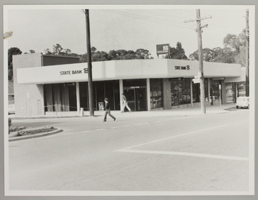
Photograph, Ringwood North State Bank , south-east corner of Dickson's Cresent and Warrandyte Road
... Cresent and Warrandyte Road...At the corner of Dickson's Cresent and Warrandyte Road... Cresent and Warrandyte Road, Ringwood North. Photographer - Les ...Photo of the new Ringwood North State Bank premises, opened 23 January 1983At the corner of Dickson's Cresent and Warrandyte Road, Ringwood North. Photographer - Les Gorrie Photography, 28 Waldemar Road, Heidelberg. Negative #82335 -
 Ringwood and District Historical Society
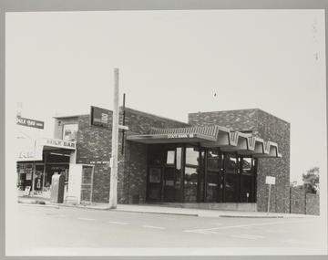
Photograph, Ringwood North State Bank , north-east corner of Dickson's Cresent and Warrandyte Road
... Cresent and Warrandyte Road...At the corner of Dickson's Cresent and Warrandyte Road... Cresent and Warrandyte Road, Ringwood North. Photographer - Les ...The new Ringwood North State Bank premises, November 1979 on the north-east corner of Dickson's Cresent. Exterior view.At the corner of Dickson's Cresent and Warrandyte Road, Ringwood North. Photographer - Les Gorrie Photography, 28 Waldemar Road, Heidelberg. Negative #2389 -
 Ringwood and District Historical Society
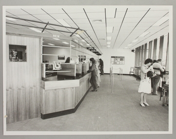
Photograph, Interior of Ringwood North State Bank , south-east corner of Dickson's Cresent and Warrandyte Road
... of Dickson's Cresent and Warrandyte Road...At the corner of Dickson's Cresent and Warrandyte Road... Cresent and Warrandyte Road, Ringwood North. Photographer - Les ...The new Ringwood North State Bank premises on the south-east corner of Dickson's Cresent. Showing customer service area. Opened 23 August 1982At the corner of Dickson's Cresent and Warrandyte Road, Ringwood North. Photographer - Les Gorrie Photography, 28 Waldemar Road, Heidelberg. Negative #82334 -
 Ringwood and District Historical Society
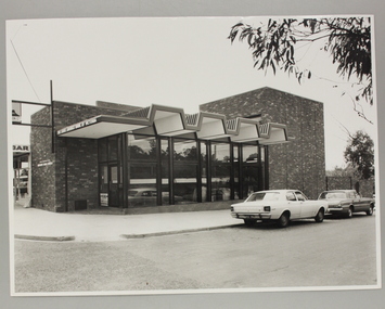
Photograph, Exterior view of Ringwood North State Bank , north-east corner of Dickson's Cresent and Warrandyte Road
... corner of Dickson's Cresent and Warrandyte Road...At the corner of Dickson's Cresent and Warrandyte Road... Cresent and Warrandyte Road, Ringwood North. Photographer Laurie ...The new Ringwood North State Bank premises on the north-east corner of Dickson's Cresent. Exterior view. Unknown date. Opened 25 October 1971At the corner of Dickson's Cresent and Warrandyte Road, Ringwood North. Photographer Laurie Richards, 4 Tower Avenue, Alphington. Negative #71-3031 -
 Ringwood and District Historical Society
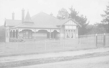
Photograph, The Crag, 69 Warrandyte Road, Ringwood
... The Crag, 69 Warrandyte Road, Ringwood. ... Warrandyte Road." Written on back of Postcard: "The Crag, 69... Warrandyte Road." Written on back of Postcard: "The Crag, 69 ...1 large black and white photograph, 1 sepia postcard- showing house with picket front fence.Written on back of black and white photograph: "About 69 Warrandyte Road." Written on back of Postcard: "The Crag, 69 Warrandyte Road, Ringwood." Early Borough of Ringwood Rate notices show that Thomas Brierley was the owner of the property from 1938 to 1949. Tenants included Lewis Lampert, Chiropractor, and later a McCann family member. -
 Ringwood and District Historical Society
Postcard, View of Ringwood looking East from Warrandyte Road /Whitehorse Road intersection. Circa 1916
... View of Ringwood looking East from Warrandyte Road... from Warrandyte Road/Whitehorse Road intersection. Circa 1916..." View of Ringwood looking East from Warrandyte Road/Whitehorse ...Sepia photograph on front of Postcard"Written on back of Postcard" View of Ringwood looking East from Warrandyte Road/Whitehorse Road intersection. Circa 1916. Presbyterian Church in foreground -
 Ringwood and District Historical Society
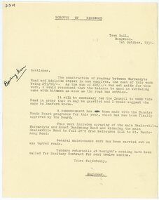
Letter, Borough of Ringwood engineer stating that a road between Warrandyte Road and Adelaide St has been completed in 1931
... Warrandyte Road and Adelaide St has been completed in 1931... Warrandyte Road and Adelaide St has been completed in 1931... Warrandyte Road and Adelaide St has been completed in 1931 ...1929 saw the establishment of the Ringwood Bowls Club initially located on the land now occupied by the Eastland Shopping Centre. It moved to its current location in Loughnan Road, Ringwood in 1997.Borough of Ringwood engineer stating that a road between Warrandyte Road and Adelaide St has been completed in 1931. The proposed name of Bamford Grove.city of ringwood bowls club, ringwood bowling club, ringwood bowls club, lawn bowls, bowling -
 Ringwood and District Historical Society
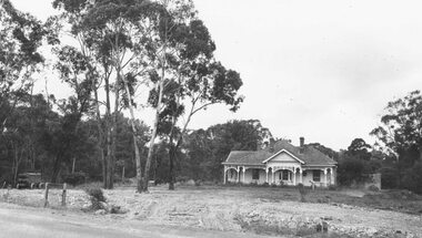
Photograph, Barrett/Polkinghorn house, Warrandyte Road, Ringwood, c1940's
... Barrett/Polkinghorn house, Warrandyte Road, Ringwood, c1940..., Warrandyte Road, Ringwood. The site became Ringwood Library in 1964..., Warrandyte Road, Ringwood. The site became Ringwood Library in 1964 ...Black and white photograph of house near Mullum Creek.Written on backing sheet: "Barrett/Polkinghorn home, Warrandyte Road, Ringwood. The site became Ringwood Library in 1964, and in 1998 the Maroondah Community Service Centre. -
 Ringwood and District Historical Society
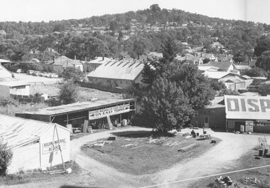
Photograph, Maroondah Highway Central, Ringwood. Corner of Warrandyte Road and Maroondah Highway taken from clock tower. 1960 including Disposal business (formerly Bamford's Timer Yard)
... Maroondah Highway Central, Ringwood. Corner of Warrandyte... and Warrandyte Road. Foreground- formerly Bamford's timber yard,. Centre... and Warrandyte Road. Foreground- formerly Bamford's timber yard,. Centre ...Black and white photograph (2 copies)Written on back of one copy: "Corner of Maroondah Highway and Warrandyte Road. Foreground- formerly Bamford's timber yard,. Centre- Presbyterian Church. Laughnan's Hill in background. -
 Ringwood and District Historical Society
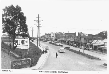
Photograph, Maroondah Highway Central, Ringwood. Whitehorse Road looking west from Warrandyte Road. c1930's
... looking west from Warrandyte Road. c1930's...., Ringwood. Image shows shops on north side of road from Warrandyte..., Ringwood. Image shows shops on north side of road from Warrandyte ...Black and white photograph (2 copies)Inscribed on photograph: "Series No 4. Whitehorse Road, Ringwood. Image shows shops on north side of road from Warrandyte Road railway bridge to Ringwood Street. -
 Eltham District Historical Society Inc
Photograph, Pound Bend Road, Warrandyte
... Pound Bend Road, Warrandyte...Five colour photographs showing Pound Bend Road, Warrandyte... melbourne pound bend road warrandyte manningham Five colour ...Five colour photographs showing Pound Bend Road, Warrandyte Northpound bend road, warrandyte, manningham -
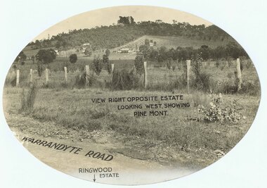
 Ringwood and District Historical Society
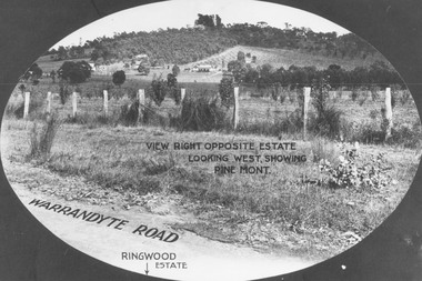
Photograph, View from Warrandyte Road opposite Ringwood Estate looking west, showing Pine Mont. (no date)
... View from Warrandyte Road opposite Ringwood Estate looking... as "Warrandyte Road" and "Ringwood Estate" printed at bottom of picture.... identified as "Warrandyte Road" and "Ringwood Estate" printed ...Printed onto photograph, "View right opposite estate looking west, showing Pine Mont". Roadway identified as "Warrandyte Road" and "Ringwood Estate" printed at bottom of picture. -
 Ringwood and District Historical Society
Letter, Buckingham Palace, Letter addressed to Mr. A Temple Miles, 'Selangor', Warrandyte Road, Ringwood. 1929, with Oval Imprint PRIVY PURSE, Buckingham Palace, 30-Apr-29
... ', Warrandyte Road, Ringwood. 1929, with Oval Imprint PRIVY PURSE...', Warrandyte Road, Ringwood. Black ink Circular imprint 30 -Apr-29...', Warrandyte Road, Ringwood. Black ink Circular imprint 30 -Apr-29 ...Letter purchased by Russ Haines, President of RDHS from Dealer in Blackburn. Text of the letter reads; The Private Secretary is commanded by the King to thank Mrs. A Temple Miles for her letter of the 17th. March. reply dated 30th. April 1929.Letter addressed to Mr. A Temple Miles, 'Selangor', Warrandyte Road, Ringwood. Black ink Circular imprint 30 -Apr-29 Official Paid, NSW. Red ink Oval imprint PRIVY PURSE Buckingham Palace with image of Crown (shape) Purple ink. Small red crown on back of envelope. +Additional Keywords: Temlpe Miles Mrs. A., The King -
 Ringwood and District Historical Society
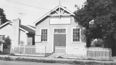
Photograph, Salvation Army Hall, Warrandyte Road, Ringwood - circa 1960s
... Salvation Army Hall, Warrandyte Road, Ringwood - circa...Typed below photograph, "Salvation Army Hall, Warrandyte..., "Salvation Army Hall, Warrandyte Road, Built 1920." Written ...Black and white photograph of wooden building with picket fence.Typed below photograph, "Salvation Army Hall, Warrandyte Road, Built 1920." Written on backing sheet, "Sal. Army Hall, 1/1964. Built 1920, W'dyte Rd." -
 Ringwood and District Historical Society
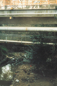
Photograph, Ringwood, Mullum Mullum Creek, east side. Warrandyte Road Bridge. 1986
... Ringwood, Mullum Mullum Creek, east side. Warrandyte Road.... Ringwood, Mullum Mullum Creek, east side. Warrandyte Road Bridge"..... Warrandyte Road Bridge". Ringwood, Mullum Mullum Creek, east side ...Written on backing sheet, "Bridge, Mullum Rd. Completed May 1987." Writing on back of photograph reads, "Aug., 1986. Ringwood, Mullum Mullum Creek, east side. Warrandyte Road Bridge". -
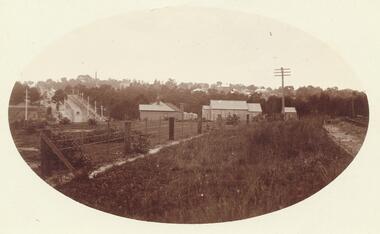
 Ringwood and District Historical Society
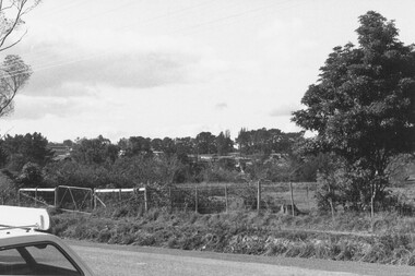
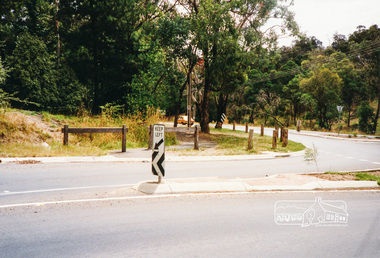
Photograph, Looking N.E. across Warrandyte Road 150 yards north of Oban Rd. at the houses around and SE of Parkwood High School 1981
... Looking N.E. across Warrandyte Road 150 yards north of Oban.... Looking N.E. across Warrandyte Road 150 yards north of Oban Rd..., E607, N10, 19/6/1981. Looking N.E. across Warrandyte Road 150 ...Written on back of photograph, E607, N10, 19/6/1981. Looking N.E. across Warrandyte Road 150 yards north of Oban Rd. at the houses around and SE of Parkwood High School". -
 Ringwood and District Historical Society
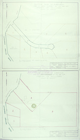
Document - Folder, Land Sale - Monterey Park Subdivision, Warrandyte Road, Ringwood North, Vic. - 1981
... Land Sale - Monterey Park Subdivision, Warrandyte Road...), Radiata Close, Old Warrandyte Road, and entry from Warrandyte Road...), Radiata Close, Old Warrandyte Road, and entry from Warrandyte Road ...Foolscap manilla folder containing double-sided flyer advertising residential subdivision development, including outline of local facilities and services, with locality map and layout of Monterey Park streets. Subdivision includes Parkwood High School, Tortice Drive, Heape Way, Appleberry Place, Stringybark Court, Conifer Court, Crawley Grove, Monterey Close (later Monterey Place), Lucy Place, Middlebrook Drive, Gahnia Close, Glanfield Court, Cone Close, Jull Parade, Pinus Close (later Pinetree Court), Radiata Close, Old Warrandyte Road, and entry from Warrandyte Road. Vendor - Jennings Industries Limited, 690 Springvale Road, Mulgrave, 3170, Phone 5618000. A4 enclosures with tables showing each allotment List Price, Builders Price, Cash Price and Terms Price. Information page headed "Form of Restrictive Covenant to be incorporated in Transfer" specific to Certificates of Title. Restrictive Covenant (summary): (Name/s) "... will not erect or construct or cause to be erected or constructed on the land hereby transferred (a) Any front boundary fence, other than a fence which does not exceed one metre in height unless the same is set back as least 1.5 metres from the front boundary and the same is effectively screened from that boundary by the planting of trees, shrubs or plants. (b) Any side boundary fence other than a fence which is set back at least 1.5 metres from the front boundary on which does not exceed 1 metre in height within 1.5 metres of the front boundary. (c) For a period of 5 years from the date hereof, any building on the said land unless and until the Plans and Specifications thereof have first been approved by the said Residential Developments Pty. Limited. (d) For a period of 2 years from the date hereof whilst the said land remains vacant any Signboard or Notice advertising the sale of the said lot or any other lot. These covenants shall appear on the Certificate of Title to issue for the said land and run with the land." -
 Ringwood and District Historical Society
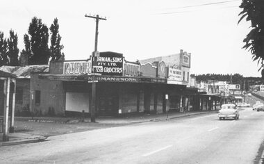
Photograph, Maroondah Highway Central, Ringwood. Corner Main Street & Adelaide St. looking east towards Warrandyte Road- 1966
... & Adelaide St. looking east towards Warrandyte Road- 1966..... looking east towards Warrandyte Road - 1966". Image shows Norman... Main Street & Adelaide St. looking east towards Warrandyte Road ...History of the Norman Cash Grocery Stores. Normans started grocery store in Drummond Street Oakleigh in 1903 and expanded to 13 stores in adjacent suburbs, Ringwood being one of these. Photo is Norman & Sons P/L corner of Maroondah Highway and Adelaide Street.Black and white photograph (2 copies) Typed below one copy: "Corner Main Street & Adelaide St. looking east towards Warrandyte Road - 1966". Image shows Norman & Sons Grocer store on corner of Adelaide Street and Main Street. -
 Ringwood and District Historical Society
Photograph, Promotional photograph - View opposite Ringwood Estate, Warrandyte Road, looking west towards Pine Mont. (no date)
... , Warrandyte Road, looking west towards Pine Mont. (no date)... looking west, showing Pine Mont. Warrandyte Road". Catalogue.... Warrandyte Road". Catalogue card reads, "Pinemont Estate (Loughnan's ...Printing on photograph reads, "View right opposite estate looking west, showing Pine Mont. Warrandyte Road". Catalogue card reads, "Pinemont Estate (Loughnan's Hill). Right opposite estate looking west." -
 Ringwood and District Historical Society
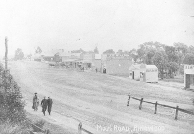
Photograph, Maroondah Highway Central, Ringwood. Looking west from Warrandyte Road, 1910
... Warrandyte Road, 1910.... Road, Ringwood, looking west, Warrandyte Road coming in from... Road, Ringwood, looking west, Warrandyte Road coming in from ...Black and white photograph (2 copies)Written on rear of backing sheet of one photograph: "Main Road, Ringwood, looking west, Warrandyte Road coming in from right.". Image of central Ringwood including the E.S.& A. bank, Ringwood's first bank, 1910. -
 Ringwood and District Historical Society
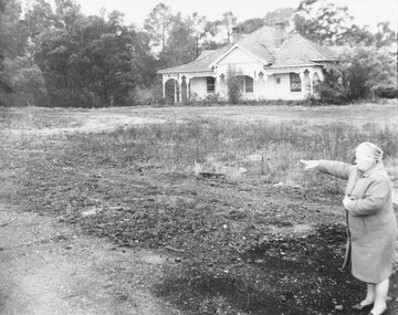
Photograph, Mrs. E.V. Pullin, Chairman Library Promotion Committee pointing to new library site - 1967 - opposite Eastland and the bowling green, Warrandyte Road. Five photographs
... bowling green, Warrandyte Road. Five photographs... green, Warrandyte Road. House on the library site... - opposite Eastland and the bowling green, Warrandyte Road. House ...Mrs. E.V. Pullin, Chairman Library Promotion Committee pointing to library site - 1967 - opposite Eastland and the bowling green, Warrandyte Road. House on the library site was demolished at the end of 1968 and the library opened on 2nd May 1970. -
 Ringwood and District Historical Society
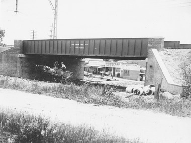
Photograph, Maroondah Highway Central, Ringwood. Construction of Warrandyte Road railway viaduct, 1923
... Warrandyte Road railway viaduct, 1923....Typed below photograph: "Construction of Warrandyte Road...Typed below photograph: "Construction of Warrandyte Road ...Black and white photograph (2 copies)Typed below photograph: "Construction of Warrandyte Road railway viaduct, Ringwood - 1923." Maroondah Highway shops in background later redeveloped as the site of Safeway supermarket then Officeworks office supplies outlet, prior to Eastland Shopping Centre expansion in 2015. -
 Eltham District Historical Society Inc
Photograph, Main Road, Research
... research warrandyte road... and one viewed from Warrandyte Road near the roundabout... melbourne eltham east research main road research warrandyte road ...Three colour photographs of Main Road between Research and Eltham East; two showing the bike path looking tworads Eltham and one viewed from Warrandyte Road near the roundabouteltham east, research, main road, research warrandyte road, warrandyte road, paths, bike paths -
 Ringwood and District Historical Society
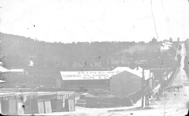
Photograph, Maroondah Highway Central, Ringwood. Bamford's Timber Yard, Warrandyte Road, (Formerly Andersons Creek Rd.) Cnr. Maroondah Highway
... , Warrandyte Road, (Formerly Andersons Creek Rd.) Cnr. Maroondah...Typed below one large copy: "Warrandyte Road, (formerly...Typed below one large copy: "Warrandyte Road, (formerly ...Black and white photograph (3 copies- 2 large, 1 small postcard) Typed below one large copy: "Warrandyte Road, (formerly Andersons Creek Road.) Cnr. Maroondah Highway. Bamfords Timberyard in foreground later redeveloped as the site of Safeway's site and area beyond it now Eastland." Written on rear of backing sheet: "Bamford Bros. Timberyard - (later) Safeways C/r Whitehorse Rd. and Warrandyte Rd. Looking Nth along Warrandyte Rd. Loughnans Hill to left" -
 Eltham District Historical Society Inc
Slide - Photograph, Eltham Shire Council, Proposed plan of subdivision, Mrs Du Lee, Warrandyte, 1969
... Research-Warrandyte Road...B2, Du Lee Subdivision, Research-Warrandyte Road, 4 August... Road Research-Warrandyte Road B2, Du Lee Subdivision, Research ...35mm colour positive transparency blue Agfacolour Service plastic mountB2, Du Lee Subdivision, Research-Warrandyte Road, 4 August 1969infrastructure, map, planning, subdivison lots, du lee, glynns road, research-warrandyte road -
 Ringwood and District Historical Society
Photograph, 12 Warrandyte Road, Ringwood. Now a car park for 10 Warrandyte Road 21 October 1992
... 12 Warrandyte Road, Ringwood. Now a car park for 10... Road Ringwood North melbourne Digital photograph 12 Warrandyte ...Digital photograph -
 Ringwood and District Historical Society
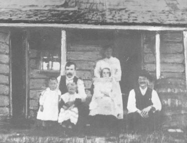
Photograph, Britten Family and home. Warrandyte Road, Ringwood. c1907
... Britten Family and home. Warrandyte Road, Ringwood. c1907.... (site became Church of England, Warrandyte Road). Note log... (site became Church of England, Warrandyte Road). Note log walls ...Black and white photograph of family group at rear of house. (2 copies- 1 large, 1 small). Small copy mounted on cardboard backing.Typed under large photograph, "Britten Family and home (site became Church of England, Warrandyte Road). Note log walls and rain-water barrel at this pioneer home. c 1907." Written on rear of small photograph: "Wm Grace (1876), James Claridge (1880s) C.G. Britten (1905). All occupied this cottage on site now Church of England vicarage, Warrandyte Rd. Ringwood. Group from left. C.G. Britten holding daughter (Muriel) with son (Reg) on his right. His wife (nee Ethel Banks, Claridges' granddaughter) at rear with her sister in front, and brother Wally on extreme right. (Back of house)." -
 Eltham District Historical Society Inc
Slide - Photograph, Eltham Shire Council, Plan of Subdivision, Crown Allotment 8, Section 8A, Parish of Nillumbik,County of Evelyn, 1969
... Research-Warrandyte Road...C1, Pain, Sibbel and Carter, Research-Warrandyte Road... of Nillumbik Plan of Subdivision planning Research-Warrandyte Road ...35mm colour positive transparency blue Agfacolour Service plastic mountC1, Pain, Sibbel and Carter, Research-Warrandyte Road, North Warrandyte, 4 August 1969carter, infrastructure, map, north warrandyte, pain, parish of nillumbik, plan of subdivision, planning, research-warrandyte road, sibbel, subdivison lots -
 Eltham District Historical Society Inc
Slide - Photograph, Eltham Shire Council, Tentative Plan of Subdivision, Part of Crown Allotment 20A and Part 20B, Parish of Nillumbik, County of Evelyn, 1969
... Kangaroo Ground-Warrandyte Road... Road, North Warrandyte, 4 August 1969... Ground-Warrandyte Road North Warrandyte E2, N899, Young ...35mm colour positive transparency blue Agfacolour Service plastic mountE2, N899, Young subdivision, Kangaroo Ground-Warrandyte Road, North Warrandyte, 4 August 1969infrastructure, map, planning, subdivison lots, kangaroo ground-warrandyte road, north warrandyte -
 Eltham District Historical Society Inc
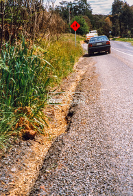
Photograph - Colour Print, Eltham Shire Council, Roadside verge issue, unidentified road, Eltham diistrict, c.1990, c.1990
... Research-Warrandyte Road...Possibly Research-Warrandyte Road near Research... melbourne Possibly Research-Warrandyte Road near Research ELL731 ...Possibly Research-Warrandyte Road near Researchell731 (vic reg), infrastructure, research (vic.), research-warrandyte road, roads, shire of eltham