Showing 111524 items matching " road"
-
 Whitehorse Historical Society Inc.
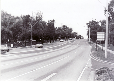
Photograph, Canterbury Road, Blackburn, 6/01/2001 12:00:00 AM
Black and white photograph of Canterbury Road, Blackburn looking west from corner of Blackburn Road.canterbury road, blackburn., blackburn road -
 Whitehorse Historical Society Inc.
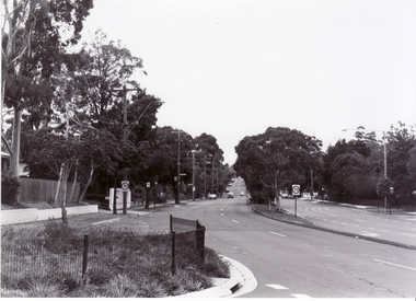
Photograph, Blackburn Road, Blackburn, 6/01/2001 12:00:00 AM
Black and white photograph of Blackburn Road, Blackburn South looking south from Canterbury Road.blackburn road, blackburn south, canterbury road -
 Whitehorse Historical Society Inc.
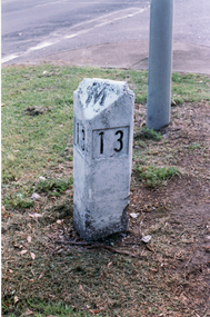
Photograph, Road Marker
Coloured photo of Road Marker on Median Strip, corner Whitehorse Road and Peel Street, Mitcham.whitehorse road, mitcham, peel street, road markers -
 Whitehorse Historical Society Inc.
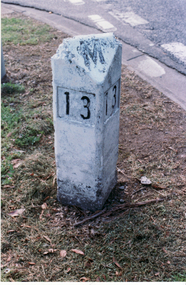
Photograph, Road Marker
Coloured photo of Road Marker on Median Strip, corner Whitehorse Road and Peel Street, Mitcham.whitehorse road, mitcham, peel street, road markers -
 Surrey Hills Historical Society Collection
Document - Contract of sale, Contract of sale for 33 Kingston Road, Surrey Hills
No 33 Kingston Road is a red brick attic-style house which was built c1920. Edward Edwards (1880-1963) was a blacksmith and the first owner. The house was named 'Berwyn' (Ref: 1931 electoral roll). Edward's wife was Mary Kennedy Stewart (1873-1931). They had 7 children, all born before the family came to Surrey Hills: 1. Hazel Margaret Kennedy Edwards (1896-1966) - dressmaker in 1931 electoral roll 2. Edward Alexander Edwards (1898-1988) 3. Mary Gwendolyn Edwards(1899-1942) 4. Gladys Annie Edwards (1902-1988) - hairdresser in 1931 electoral roll 5. Clarence Edwards (1906-1988) - plumber in 1931 electoral roll 6. Alan Stewart Edwards (1909 - 1996) 7. Geoffrey Ellis Edwards (1910-1985). The property passed to Edward Henderson Redpath after Edward Edward's death. He was a mechanic. (Ref: 1963 electoral roll). He was born in Shilbottle England on 3 December 1904 and married Gladys Annie Edwards in 1932 (#8417). He served in the Australian Airforce during WW2. Thus, the property was owned by the same family for over 40 years. Edward Henderson Redpath sold the property to David Murray Flynn and Heather Rosemary Flynn of 18 Kingston Road, Surrey Hills in 1965. Associated records: 1. Letter from George Henderson P/L to T Redpath, 1965 2. Letter re estate of E H Redpath, 1969. A standard folded real estate contract of sale for 33 Kingston Road, Surrey Hills, dated 14 August 1965edward edwards, berwyn, 33 kingston road, mary stewart kennedy, mary stewart edwards, houses, real estate contracts, legal documents, hazel margaret kennedy edwards, edward alexander edwards, mary gwendolyn edwards, gladys annie edwards, clarence edwards, alan stewart edwards, geoffrey ellis edwards, edward henderson redpath, gladys annie redpath, david murray flynn, heather rosemary flynn, house names -
 Eltham District Historical Society Inc
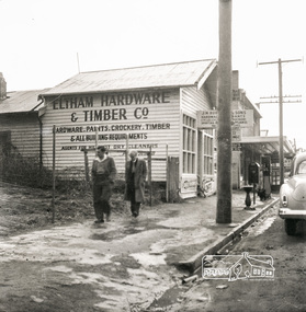
Photograph, Eltham Hardware and Timber Co, Main Road, Eltham, opposite Railway Station. c.1952, 1952c
The Eltham Hardware and Timber Company first opened on Main Road opposite the Railway Station around late 1922. An advertisement placed in the Hurstbridge Advertiser advised that the Hardware Store had just opened with a varied stock of Saws, Hammers, Nails, Shovels, Screw Drivers, and every article required in a house or on a farm. People were also encouraged to try their Jams, Pickles, Sauces, Cups and Saucers, etc. A few months later in May 1923, William Walker, a plumber, placed an advertisement wishing to to announce that he had taken over the ELTHAM HARDWARE STORE, and asked for the continued support of the district. He also noted that all kinds of Plumbing work was done. Walker remained the proprietor of the Hardware Store for many years regularly advertising its services and wares up until at least 1941. The trail goes a bit quiet then but he does appear in the 1944 Electoral Roll listed as a Plumber, of Main Street, Eltham. However he is not listed in the 1949 Electoral Roll but his son, Thomas Roy Walker, also a plumber of Main Road is listed. Thomas had been on active duty overseas during the Second World War and returned at the end of 1945. It is assumed that William died sometime between 1945 and 1949. On November 18th, 1950 the Hardware Store and residence was auctioned on site by Scarff Bros. Pty Ltd. It is presumed that this is when J.N. Burgoyne and Sons took over the business. It would have been around this time the picture of the store was taken for only three years later, in October 1953, the business and dwelling was again put up for sale, this time by Trebilcock Bros, in two separate lots. LOT 1. — ELTHAM HARDWARE AND TIMBER CO. Freehold and Property, Plant, Fittings and Business; Plus Stock at Valuation. To be Sold as a Going Concern. THE FREEHOLD PROPERTY Comprises Large Brick and Timber Shop. Well Fitted. Has Good Light. Comfortable 3-Room Dwelling and Detached Bungalow, H.W.S., Phone, Garage and Outbuildings. Situate on Large Allotment, 50 Ft. x 150 Ft. Aprox. THE BUSINESS: Flourishing Hardware and Builders’ Supplies, Crockery, Glassware and Gifts, Dry Cleaning Agency and Petrol Reseller Licence (1 Bowser Installed), Oil Storage. Annual Turnover Aprox. £12,000. Audited Figures Available, Old-established Business Comprehensive Stock is Good, Clean and Saleable (Value Approx. £4000). TERMS: £1000 Deposit, Balance 30 Days. VACANT POSSESSION. LOT 2. — Superb Shop Sites. Adjoining the Above Property. Land 58 Ft. x 150 Ft. (Approx.). Erected on Land Is Old Style 4-r Timber Dwelling, Set Well Back from Footpath. Leaving Ample Apace to erect Shops. Also Small Shop Let as Agent’s Office. To Be Sold Subject to Existing Tenancies, Gross Rentals £106 12/ Per Annum. Terms: £1000 Deposit, Balance 30 days. GENERAL: Eltham Is a Rapidly Developing Area only 12 Miles from G.P.O. Street Frontage of these Two Adjoining Properties Is 108 Feet By Depth of 150 Feet in the Heart of Expanding Shopping Centre, directly Opposite Station Entrance. Full Details and Inspection Available on Application from the Auctioneers: TREBILCOCK BROS. AUCTIONEERS and ESTATE AGENTS, Coincidentally, the Hardware Store was taken over by Richard Phillip Trebilcock, an electrical engineer from Mayona Road, MontmorencyNegative black and white film 120 6x6 formatSingle frameeltham, main road, 1951 chevrolet deluxe, ampol, eltham hardware and timber, j.n. burgoyne and sons, petrol bowser, william walker, richard phillip trebilcock -
Whitehorse Historical Society Inc.
Book, Wandering Whitehorse Road, 2014
A history of Whitehorse Road.A history of Whitehorse Road.A history of Whitehorse Road.whitehorse road, history -
 Whitehorse Historical Society Inc.
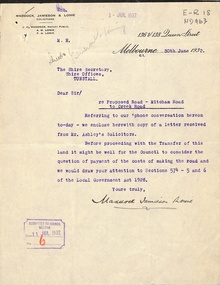
Letter - Correspondence, Mitcham Road, 1932
Correspondence between Shire Secretary, Shire of Blackburn and Mitcham and vendors and their solicitors re transfer of land for a road between Mitcham Road and Creek Road, Mitcham, June - July 1932.mitcham road, mitcham, creek road, mitcham, shire of blackburn and mitcham, maddocks, jamieson & lonie, solicitors, ashley (mr), bloom, f.a., roads and streets -
 Mt Dandenong & District Historical Society Inc.
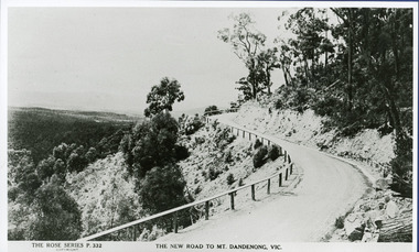
Photograph, The New Road to Mt. Dandenong Vic. c1935, c1935
Rose Series Postcard number 332c1935. Enlarged for display from Rose postcard 'New Road' (Mt. Dandenong Tourist Road). Completed by 1930 but no bitumen as yet. Road not wider and rail along outer edge.kalorama, rose series, mt. dandenong tourist road -
 Surrey Hills Historical Society Collection
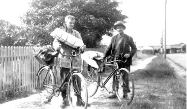
Photograph, Mr Joyce and Mr Lamble of Essex Road, Surrey Hills, c 1932, 1932
Date is approximate - early 1930s. Mr Oswald Joyce and Mr Bert Lamble used to ride their bicycles to the country to find work when they became unemployed. This included reworking old gold mines. Here they are seen leaving for Enoch's Point where they fossicked for gold during the Depression. A check of the electoral rolls points to this being the home of Frederick Harry Percival Lamble, labourer, born in Collingwood. He and his family continued to live at 87 Essex Road until his death in 1968 and his occupation is consistently given as labourer. His wife Bessie Louisa Woods died in 1957.Black and white photo of 2 men identified, but not specifically, as Mr Joyce and Mr Lamble, both of Essex Road, Surrey Hills. They are standing next to their bicycles on a roughly made path. The bikes are loaded up with swags and kit as if the two are about to depart on a journey. Behind is a picket fence and in the background the shops along Canterbury Road can be seen.essex road, frederick harry percival (mr), bicycles, depression, 1929-1939, unemployment, economic depression, mr joyce, bert lamble, frederick harry percival lamble, bessie ethel lamble, bessie ethel smith -
Whitehorse Historical Society Inc.
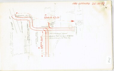
Map, Boronia Road, Canterbury Road intersection, c1970
Enlarged aerial photograph of the intersection of Canterbury and Boronia Roads. State Aerial Survey, Melbourne 1970 project.Enlarged aerial photograph of the intersection of Canterbury and Boronia Roads. State Aerial Survey, Melbourne 1970 project.Enlarged aerial photograph of the intersection of Canterbury and Boronia Roads. State Aerial Survey, Melbourne 1970 project.boronia road, vermont, canterbury road, vermont, mitcham road, vermont, frances avenue, vermont, nurlendi road, vermont, beaumont street, vermont, kingsclere street, vermont, webb court, vermont, aerial photographs -
 Melbourne Tram Museum
Document - Research Notes, H. S. McComb, Domain Road, Park St, Toorak Road and Chapel St lines, c1930
Notes 6 pages, pinned together, giving details, opening dates, terminals, depot entries, sheave pits, curves, for the Domain Road, Park St, Toorak Road and Chapel St lines. Second set of notes 4 pages for the Port Melbourne and South Melbourne beach lines via City Road and Victoria St respectively. Single page sketches for both the Flemington Road via North Melbourne and Spencer St to North Melbourne lines - no dimensions or survey notes. Items 2064 to 2075 within box 72.3 in a brown folder marked "MT&O Co." red pencil on the front cover.trams, tramways, mto co, cable trams, drawings, reports, surveys, toorak rd, chapel st, south melbourne beach, port melbourne, city rd, victoria st, north melbourne, flemington rd -
 Eltham District Historical Society Inc
Photograph, Main Road, Lower Plenty
Black and white photograph of Main Road, Lower Plenty looking west from Old Eltham Roadlower plenty, main road, old eltham road -
 Ringwood and District Historical Society
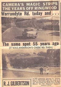
Newspaper - Photographs and Clippings, Article comparing Warrandyte Road, Ringwood, in 1912 and 1967
Newspaper cutting showing a photos of Warrandyte Road, taken from Mullum Mullum Road, in 1912 and 1967.Extract from Eastern Post Gazette 13 December 1967, page 39 -
 Ringwood and District Historical Society
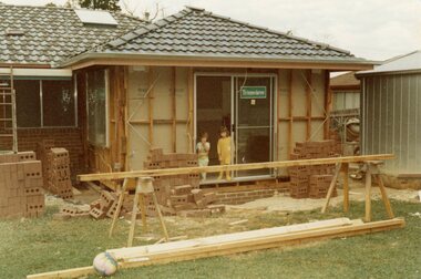
Photograph, Adding a room onto the Mitchell house at 168 Oban Road, North Ringwood in February 1979
Near the corner of Cormistom Road and Florence Avenue onto Oban Road. The house is still there today (2024).Taken by Roy J Mitchell -
Whitehorse Historical Society Inc.
Document - Correspondence, Healesville Road, 1/09/1937
Claim for reimbursement from Country Roads Board for amounts expended on the Burwood Road by Shire of Blackburn and Mitcham.burwood road, roads and streets, shire of blackburn and mitcham, victoria. country roads board -
Whitehorse Historical Society Inc.
Document - Correspondence, Burwood Road, 25/11/1937
Claim for reimbursement from Country Roads Board for amounts expended on Burwood Road by Shire of Blackburn and Mitchamburwood road, shire of blackburn and mitcham, victoria. country roads board, roads and streets -
Whitehorse Historical Society Inc.
Document - Correspondence, Burwood Road, 16/12/1937
Claim for reimbursement from Country Roads Board for amounts expended on Burwood Road by Shire of Blackburn and Mitchamshire of blackburn and mitcham, victoria. country roads board, burwood road, roads and streets -
 Whitehorse Historical Society Inc.
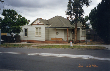
Photograph, Whitehorse Road, Mitcham No.427, 21/12/2001 12:00:00 AM
Coloured photograph of 427 Whitehorse Road, Mitcham showing Dunlavin Road side of house being renovated.whitehorse road, mitcham, no.427 -
 Whitehorse Historical Society Inc.
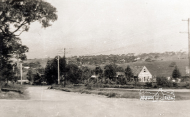
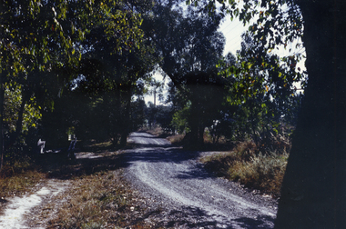
Photograph, Glenburnie Road, Vermont, 1967
Part of Tim Shambrook's Collection for 'This is Vermont'. Not used.Coloured photo of Glenburnie Road, Vermont, taken in 1967, showing dirt track before road was made.glenburnie road, vermont, shambrook, tim -
 Whitehorse Historical Society Inc.
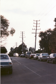
Photograph, Cnr. Cochrane & Whitehorse Road, 1/06/1999 12:00:00 AM
Coloured photo looking towards Mitcham Road from Corner Cochrane Street and Whitehorse Road, Mitcham.whitehorse road mitcham, cochrane street mitcham, overhead powerlines -
 Whitehorse Historical Society Inc.
Photograph, Canterbury Road Vermont
Coloured print of a 110 slide of the making of the dual highway of Canterbury Road Vermont, near Mitcham Road.canterbury road vermont, mitcham road, vermont, roads and streets -
 Whitehorse Historical Society Inc.
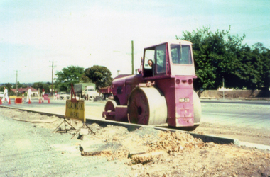
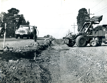
Photograph, Roadworks in Canterbury Road, Forest Hill
Black and white photo of Roadworks in Canterbury Road, Forest Hill. east of Springvale Road in conjunction with C.R.B.canterbury road, forest hill, victoria. country roads board -
 Whitehorse Historical Society Inc.
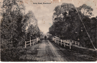
Postcard, Surry (Sic) Road, Blackburn
Black and white Postcard entitled Surry (sic) Road, Blackburn. Shows unmade road, bridge and jinker.surrey road, blackburn. -
 Whitehorse Historical Society Inc.
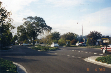
Photograph, Whitehorse Road, Mitcham
Coloured photo of Whitehorse Road looking east from the corner of Doncaster East Road. Taken 2003whitehorse road, mitcham -
 Coal Creek Community Park & Museum
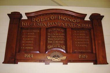
Honour Roll, Kilcunda Road School Honor Roll
This WWI Honor Roll was originally displayed in the Kilcunda Road State School (no.3337), which was located at the north east corner of the intersection of the Bena - Kongwak and Buchanans' Roads, Bena, Victoria, 3946. The school was located amongst the cypress trees at 645 Bena-Kongwak Road. The school was relocated in 2008 to the Coal Creek Community Park and Museum, 12 Silkstone Road, Korumburra, 3950 to become the Masonic Lodge building in the park display. On the west side of the intersection of the Bena - Kongwak and Buchanans' Roads is a brass plaque on a granite boulder with the following inscription TO COMMEMORATE THE DISTRICT OF KILCUNDA ROAD First Surveyed 1879. This is the site of the KILCUNDA ROAD UNITING CHURCH 1911 to 1966. Diagonally opposite at 645 Bena-Kongwak Road was the site of the KILCUNDA ROAD PRIMARY SCHOOL No: 3337, 1902 to 1975. Erected by The School Mother’s Club continuing as The Kilcunda Road Social Club 2008. One of the few remaining historic items from Kilcunda Road settlement.Honour roll of varnished wood, with three panels, an undulating shaped pediment, plain columns at sides, painted gold text and the Australian Imperial Forces insignia on base.Roll of Honor, Kilcunda Road State School. In Honor of Old Scholars of this school who served the Empire in the Great War, 1914-1919, Australian Imperial Force. (X) These made the supreme sacrifice. Sister J.E. Turner , E.N. Barge, E.F. Binding (X), E.H. Bunn, D. James (X), W.James, A. James (X), R. H. James, A.G. Rose (X), C.W. Stanlake, G. Wuchatsch, R. Wuchatsch, T.E. Young kilcunda road, honour roll, state school no.3337., wwi -
 Ringwood and District Historical Society
Article - Newspaper Clipping, Land Sale Advertisements, Golden Hill Estate, Ringwood - 1965, 1966, and Plan of Survey of Lot 8, Mullum Mullum Road Ringwood, 1970
Newspaper clippings from Melbourne Sun newspaper (11th December 1965 and 15th January 1966) advertising sale of land - Golden Hill Estate, Ringwood, with summary of features and aerial photograph including artistic representation of street layout. Subdivision includes Mullum Mullum Road, Sonia Street, Jill Court, Linda Drive, Eve Court, Alma Court, and Jacynthe Court. Attachments include reference to Lot 46 as site of original Peter Vergers' orchard residence and subsequent 1970 surveyor's Plan of Survey of Lot 8 Mullum Mullum Road Ringwood, LP 67513, Cert of Title 8581/429.Agent - Aaron, King & Co., Suite 2, 33 Queens Road, Melbourne. (Phone) 26-2443, A.H. 850-2195. Plan of Survey signed on 25.7.1970 by Roger M. Gamble, Land Surveyor, 28 Summit Crescent, Ringwood 3134. -
 Glen Eira Historical Society
Album - Album page, Bureel (Kooyong Road), Circa 1972
This photograph is part of the Caulfield Historical Album 1972. This album was created in approximately 1972 as part of a project by the Caulfield Historical Society to assist in identifying buildings worthy of preservation. The album is related to a Survey the Caulfield Historical Society developed in collaboration with the National Trust of Australia (Victoria) and Caulfield City Council to identify historic buildings within the City of Caulfield that warranted the protection of a National Trust Classification. Principal photographer thought to be Trevor Hart, member of Caulfield Historical Society. Most photographs were taken between 1966-1972 with a small number of photographs being older and from unknown sources. All photographs are black and white except where stated, with 386 photographs over 198 pages. From: Glen Eira Heritage Management Plan 1996 by Andrew Ward In 1856, John Allee, a builder from Brighton, purchased C.A. 37 on the south-west corner of Glenhuntly and Kooyong Roads. The land comprised just over 45 acres. By 1863, Francis John Sidney Stephen, a lawyer and cousin of J. Wilberforce Stephen, owned most of lot 37. By 1866, Stephen had a built a "small mansion" named ''Burreel". It was a brick house and Stephen lived there until 1882. By 1884, Mrs Buxton of Hillside Terrace, East Melbourne, had purchased the property. Richard Buxton, a gentleman was listed as occupant and the house described as "brick, eight rooms". NAV was £300. Richard Buxton continued residency in 1887 however in 1888, George Allen, music seller, became occupant. At that time the house had thirteen rooms on twenty-three acres of land. Twelve people lived there and NAV was £920. In 1900, Daniel Luxton, stock and sharebroker and the Honourable John Taverner, M.H.A. leased the property. Fourteen people lived there. Mrs Buxton continued as owner. By 1910, ownership had passed to Mrs Mary Neate, who converted the house to a nursing home. The land had been subdivided by 1913 and sold by ''Buxtons Estate". Burreel Avenue, Baxter, Buxton and Hoddle Streets were created. "Burreel" was rated to Burreel Avenue and stood on lot 13 with frontages to Burreel Avenue and Kooyong Road of 198' and 214'. The house had ten rooms. NAV was £60. Mary Neate, a nurse, continued as owner/ operator of ''Burreel" nursing home in 1927. At that time there were sixteen rooms and fourteen residents. NAV was £100. Mrs Neat remained there until 1947. In 1948, the house was turned into apartments. In the 1980's, the Alexander family purchased it and restored it to a private residence.Burreel 331 Kooyong Road, ELSTERNWICK VIC 3185 - Property No B4950 National Trust https://vhd.heritagecouncil.vic.gov.au/places/65648 This is a large and substantially intact example of the grand villas of nineteenth century Melbourne. The bulk of the house most probably was built in 1866-1868 for Francis John Sidney Stephen, a prominent and highly regarded Melbourne solicitor and a member of an illustrious legal family. Stephen conducted a lucrative private practice and in 1845 was appointed first solicitor to the City of Melbourne; a position he held until his death in 1895. He took an active part in the development of Caulfield and was Shire President in 1874 and 1877. He was a resident at Burreel from 1868 to 1882. The house has evolved in stages, the rear wings possibly remaining from a house built during the 1850s. The existing ornate cast iron verandah was probably built between 1882 and 1888 during the residence of Richard Buckhurst Buxted, a notable boom period auctioneer and real estate agent. George Allan, the founder of Allan's music store, was another important occupier from 1888 to 1991. Bureel's essentially residential quality has been retained and the interior has been well preserved. The significance of this building does not rest in any single unusual outstanding architectural feature, or in its association with a particularly prominent member of society in the past, but rather in the consistent integrity of both the interior and exterior, which results in the survival of an outstanding example of this type of residential building and its associations with two notable citizens. Classified:11/08/1990Page 113 of photograph album with 1 photograph of Burreel in its garden.Handwritten: Bureel [top left] / 113 [bottom left]trevor hart, caulfield, caulfield north, kooyong road, thomas king, mansion, 1860's, bureel, burreel, francis john sidney stephen, city of melbourne, shire president, 1850's, verandah, nursing home, john allee, ornamented corner stones, new orleans manner, plaster rendered, mrs luxton, vincent willis, alexander family, victorian architectural style, ornate cast iron work, lawyers, brick houses, richard buxton, richard buckhurst buxton, george allen, george leavis allan, allans music, daniel luxton, john taverner, mary neate, buxtons estate, land subdivision, mary neat, gardens -
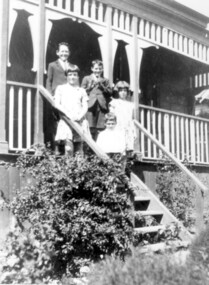 Surrey Hills Historical Society Collection
Photograph, McPhie children, of 5 Suffolk Road, Surrey Hills
5 Suffolk Road was the Mounted Police Station from 1889 - 1914.Image of a five young (school age or younger) children (three boys, two girls) standing on the exterior steps of a building identified as the Mounted Police Station, 5 Suffolk Road, Surrey Hills. The children are identified as the family of Sgt. David McPhie. The children are dressed in 'best clothes.' The main part of the building is not visible however it does have a decorative wooden verandah.people, families, family groups, children, girls, boys, police, policemen, surrey hills mounted police station, structures and establishments, police stations, david mcphie -
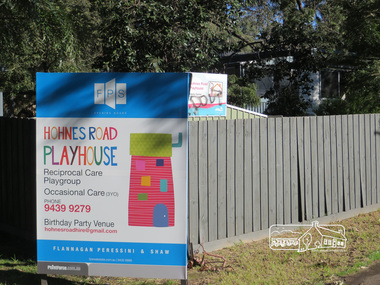 Eltham District Historical Society Inc
Photograph, Liz Pidgeon, Hohnes Road Playhouse, 1 July 2017
Photo taken as part of an EDHS Heritage Excursion - Saturday 1st July - Eltham Lower Park - Walk and Talk. "Eltham Lower Park has played an important part in the history of our area since the early days of European settlement when it was used by local residents as an informal racecourse. Prior to that its location at the junction of the Diamond Creek and the Yarra River made it an important meeting place for the Wurundjeri people. The park combines formal elements and sporting facilities with remnant bushland that is of environmental significance. It is home to sporting and horse riding clubs, popular play spaces and the Diamond Valley Miniature Railway, which attracts large numbers of visitors.The park will be the venue for our July excursion which will comprise a walk of about 3.5 km around the park and adjacent areas. Along the way we will discuss the history and natural history of the area. The path along the creek and the river provides a pleasant and scenic walk.This walk on Saturday 1st July is about 3.5 km in length and will take 2 to 2.5 hours. It will start at 2pm at the Main Road car park at the front of the park. (Melway ref 21 H 10)". Newsletter No., 234, June 2017 Born Digitalheritage excursion, activities, eltham district historical society, eltham lower park, sign, hohnes road playhouse