Showing 2312 items matching " infrastructure"
-
 Eltham District Historical Society Inc
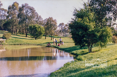
Photograph, Looking southeast across the duck pond in Eltham Town Park (Alistair Knox Park), c. Oct 1987, 1987
Date based on other similar display panels visible in images of the Shire of Eltham display at the Eltham Community Festival, 7 November 1987.Colour photographdisplay panel, eltham festival, infrastructure, shire of eltham, eltham town park, alistair knox park -
 Eltham District Historical Society Inc
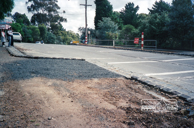
Photograph, Main Road, Panton Hill, c. November 1987, 1987
Roll of 35mm colour negative film, 7 stripsFuji 100shire of eltham, roadworks, infrastructure, main road, panton hill, road construction -
 City of Kingston
Photograph - Black and white, c. 1970
This photograph depicts the steel tramway (or tram plate) along Centre Dandenong Road, Cheltenham near the Moorabbin Airport entrance in the 1970's. These tramways played an important role in transportation along Moorabbin's major roads. Heavily laden carts could travel smoothly and safely along the steel plates when the road surfaces were often rutted and hazardous. This surviving section was later moved for road improvements. The area now known as the City of Kingston was a market garden region and the round trip to market could take as long as eight hours on poorly maintained roads. The installation of the steel tramway transformed the arduous journey faced by market gardeners in transporting their produce to market. As there was only a single tramway, the carts often travelled in convoy, enabling drivers to leave piloting to the first cart and having a rest. The rails did not speed the journey to the city, but it smoothed progress immeasurably. Black and white photograph of steel tram plates on Centre Dandenong Road, Cheltenham. The road is sealed. At the top of the image there are trees behind a parked car which is adjacent to a white shelter. There is a large sign stating MOORABBIN AIRPORT above an arrow pointing to the right in the top centre of the image. Handwritten in pencil: A 28 / [indecipherable] 3 / [indecipherable] Handwritten in red ink: A28 / 70%market gardening, infrastructure, transport, steel tramway, industry, moorabbin -
 City of Kingston
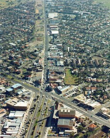
Photograph - Colour, c. 1982
This aerial photograph of South Road and Nepean Highway, Moorabbin shows the area where houses and shops on the south side of the Nepean Highway have demolished for the widening of the highway. The pressures of rapid urban development in Moorabbin and beyond, especially to the south of Moorabbin caused bottlenecks and delays, especially at the South Road and Nepean Highway intersection, hence the scheme to widen Nepean Highway.The pressures of rapid urban development in terms of people, housing construction, industrial development and commercial activity, in Moorabbin and beyond, especially to the south would put pressure on road infrastructure in the region. In the early 1980s, a major road expansion of the Nepean Highway was implemented to increase capacity on this major thoroughfare for vehicle commuters. Car use had also increased with commuters from the increasingly populous southern suburbs travelling to their place of work in the Melbourne CBD.Colour photograph of an aerial view of South Road and Nepean Highway, Moorabbin. The image shows houses on the south side of the Nepean Highway that have demolished for widening of road. It features housing and commercial buildings looking north towards Cummins Road.Handwritten blue ink: 82 - 5452 - 11 Handwritten red ink: 112% Handwritten black ink: Ch. 7nepean highway, south road, moorabbin, roads, transport, infrastructure -
 City of Kingston
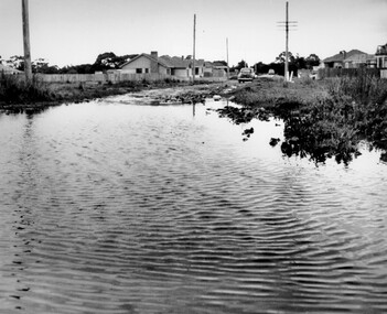
Photograph - Black and white, c. 1958
This photograph depicts flooding of Ozone Avenue in Beaumaris, located off Balcombe Road. Roads in the Beaumaris area lacked sufficient drains to clear surface water. In many cases streets were unsealed and without footpaths and some were dirt tracks. Gutters and road surfaces were made of clay and in the wetter months of winter, unsealed roads and tracks became impossible quagmires that were unnavigable for vehicles and pedestrians. In the first decade after World War II there was rapid expansion in construction of new houses in the suburb of Beaumaris. Utilities and infrastructure to support the growth of housing was inadequate and not provided for prior to the development of the area. Without rudimentary drainage, flooding was frequent. Storm water runoff, domestic sullage and septic tank overflow would form large pools and families were sometimes marooned within their homes. The frequent flooding caused isolation and hardship and residents endured difficulties with accessibility to facilities. These disadvantages had the potential to cause social issues for the new residents.Black and white photograph of flooding in Ozone Avenue, Beaumaris. The image shows floodwaters with boggy and rough terrain on an unsealed road with housing in the distance.Handwritten in blue ink: 2124 circled Handwritten in red ink: 80% Handwritten in blue ink on yellow Post-It note: Chap 6. underlined, 2194 Ozone Ave Beaumaris 1958beaumaris, ozone avenue, balcombe road, flooding, roads, infrastructure -
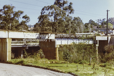
 Eltham District Historical Society Inc
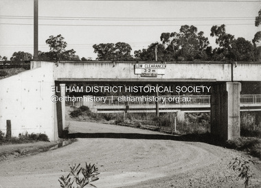
Photograph - Black and White Print, Railway Bridge across Plenty River near Railway Road, Briar Hill, Vic, c. August 1977
Para Road bridge across Plenty River can be seen behind railway bridge.Black and white photographinfrastructure, bridge, greensborough, para road bridge, railway road bridge, shire of eltham infrastructure -
 Eltham District Historical Society Inc
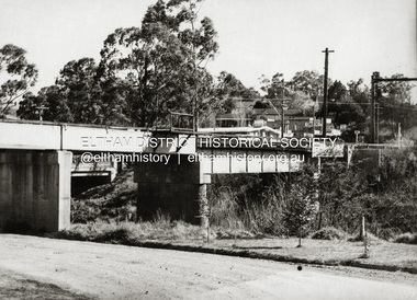
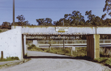
Photograph - Colour Print, Railway Bridge across Plenty River near Railway Road, Briar Hill, Vic, c. August 1977
Para Road bridge across Plenty River can be seen behind railway bridge.Colour photographinfrastructure, bridge, greensborough, para road bridge, railway road bridge, shire of eltham infrastructure -
 Eltham District Historical Society Inc
Photograph, Russell Yeoman, Fitzsimons Lane Bridge over Yarra River between Eltham and Templestowe, c.1970, 1970c
The bridge over the Yarra River was initially opened September 22nd, 1961. Newspaper reports at the time of opening stated it linked Bolton Street, Eltham, with Fitzsimons Lane, Templestowe. In 1955 the Country Roads Board (CRB) produced survey plans that showed proposed land acquisition for the future bridge and road approaches. The 1955 plan shows that it was proposed to connect Fitzsimons Lane with Bolton Street in Eltham by a diagonal road across the river. The road connection would then continue along Bolton Street to Main Road. Prior to construction of the bridge the CRB modified the proposal significantly so that there was a new road parallel with Bolton Street and then curving to join Main Road at what was then its intersection with Old Eltham Road. This involved significantly more land acquisition and altered the pattern of land subdivision through this corridor. Initially the new road was just a single two-way carriageway as it would have required a significant widening of the cutting on the Shire of Eltham side of the river. The road was officially un-named but was known locally as the Eltham-Templestowe Road. The 1966 Melway street directory and other 1960s editions also listed the road as the Eltham-Templestowe Road. In December 1970, Eltham Shire Council, in pursuance of the provisions of the Local Government Act, named it Templestowe Road. The road was renamed Fitzsimons Lane around 1984 in conformity with the section south of the river. In 1991 a new bridge was built to the west of the original bridge. Fitzsimons Lane was widened to four traffic lanes although on the Eltham side this was done within the limits of the existing cutting. NEW BRIDGE STARTS THEM EXPLORING Without any fanfares, Country Roads Board workmen on Friday afternoon put the finishing touches to the approaches, removed the barricades, and let the traffic roll over the new Yarra bridge linking Bolton Street, Eltham, with Fitzsimons Lane, Templestowe. Over the week-end many “bridge watchers” who were making one of their periodic inspections of the progress on the new bridge found to their surprise that they could drive over it, so that people who had gone for a run out to Eltham suddenly found themselves wandering through Templestowe and Doncaster. By Monday the word of the bridge’s opening had got around sufficiently for many regular travellers to the city from Eltham and beyond to vary the monotony by going to town via Templestowe and Kew instead of through Heidelberg. They were surprised at the distances – about 3 ½ miles from Eltham to Templestowe, 6 miles from Eltham Shire hall to the Lower Heidelberg Road-Banksia Street intersection. NEW NEIGHBOURS For people on both sides of the river, the new bridge has turned distant friends into near neighbours. A Greensborough man on Sunday took 35 minutes to reach the home of a friend in East Doncaster, but the return trip over the new bridge took only 17 minutes. It will be some time yet before most people work out the possibilities in shorter and quicker trips form the north-eastern areas to the eastern and south-eastern suburbs. The coming of the warmer months will soon teach many, though the short cuts to Peninsular beaches and eastern suburban drive-ins. And before very long it is likely there will be a Tramways bus running from Templestowe to Eltham station. NEW BRIDGE STARTS THEM EXPLORING (1961, September 27). The Diamond Valley News (News clipping held in SEA_74-1_047) The previously un-named road between Main Road and Yarra River, Eltham South, east of Bolton Street was named Templestowe Road, December 15, 1970 NAMING OF STREETS AND ROADS. (1970, December 15). The Diamond Valley News (News clipping held in SEA_74-2_022)Roll of 35mm black and white negative film, 4 of 7 stripsIlford HP4bridge, bridges, fitzsimons lane bridge, infrastructure, shire of eltham infrastructure, yarra river -
 Eltham District Historical Society Inc
Photograph, Fitzsimons Lane Bridge over Yarra River between Eltham and Templestowe, c.1966, 1966c
The bridge over the Yarra River was initially opened September 22nd, 1961. Newspaper reports at the time of opening stated it linked Bolton Street, Eltham, with Fitzsimons Lane, Templestowe. In 1955 the Country Roads Board (CRB) produced survey plans that showed proposed land acquisition for the future bridge and road approaches. The 1955 plan shows that it was proposed to connect Fitzsimons Lane with Bolton Street in Eltham by a diagonal road across the river. The road connection would then continue along Bolton Street to Main Road. Prior to construction of the bridge the CRB modified the proposal significantly so that there was a new road parallel with Bolton Street and then curving to join Main Road at what was then its intersection with Old Eltham Road. This involved significantly more land acquisition and altered the pattern of land subdivision through this corridor. Initially the new road was just a single two-way carriageway as it would have required a significant widening of the cutting on the Shire of Eltham side of the river. The road was officially un-named but was known locally as the Eltham-Templestowe Road. The 1966 Melway street directory and other 1960s editions also listed the road as the Eltham-Templestowe Road. In December 1970, Eltham Shire Council, in pursuance of the provisions of the Local Government Act, named it Templestowe Road. The road was renamed Fitzsimons Lane around 1984 in conformity with the section south of the river. In 1991 a new bridge was built to the west of the original bridge. Fitzsimons Lane was widened to four traffic lanes although on the Eltham side this was done within the limits of the existing cutting. NEW BRIDGE STARTS THEM EXPLORING Without any fanfares, Country Roads Board workmen on Friday afternoon put the finishing touches to the approaches, removed the barricades, and let the traffic roll over the new Yarra bridge linking Bolton Street, Eltham, with Fitzsimons Lane, Templestowe. Over the week-end many “bridge watchers” who were making one of their periodic inspections of the progress on the new bridge found to their surprise that they could drive over it, so that people who had gone for a run out to Eltham suddenly found themselves wandering through Templestowe and Doncaster. By Monday the word of the bridge’s opening had got around sufficiently for many regular travellers to the city from Eltham and beyond to vary the monotony by going to town via Templestowe and Kew instead of through Heidelberg. They were surprised at the distances – about 3 ½ miles from Eltham to Templestowe, 6 miles from Eltham Shire hall to the Lower Heidelberg Road-Banksia Street intersection. NEW NEIGHBOURS For people on both sides of the river, the new bridge has turned distant friends into near neighbours. A Greensborough man on Sunday took 35 minutes to reach the home of a friend in East Doncaster, but the return trip over the new bridge took only 17 minutes. It will be some time yet before most people work out the possibilities in shorter and quicker trips form the north-eastern areas to the eastern and south-eastern suburbs. The coming of the warmer months will soon teach many, though the short cuts to Peninsular beaches and eastern suburban drive-ins. And before very long it is likely there will be a Tramways bus running from Templestowe to Eltham station. NEW BRIDGE STARTS THEM EXPLORING (1961, September 27). The Diamond Valley News (News clipping held in SEA_74-1_047) The previously un-named road between Main Road and Yarra River, Eltham South, east of Bolton Street was named Templestowe Road, December 15, 1970 NAMING OF STREETS AND ROADS. (1970, December 15). The Diamond Valley News (News clipping held in SEA_74-2_022)Black and white photographManufacturer's marks: Polaroid, Batch #J62K181 (Sep 1966).infrastructure, shire of eltham infrastructure, bridge, fitzsimons lane bridge, polaroid, yarra river -
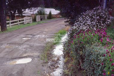 Eltham District Historical Society Inc
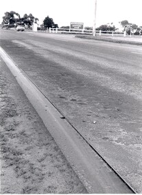
Photograph - Colour Print, Potholes in unidentified unsealed road, near Eltham, c.1990
Other frame was view of similar road conditions at Haldane and Metery Roads, Eltham. Council officers reviewing road surface breakdown due to weather conditions and road traffic causing potholes and dips.Roll of 35mm colour positive film, 2 separated framesKodak 5005 EPPeltham, houses, infrastructure, potholes, streets, streetscape -
 Melbourne Tram Museum
Pamphlet, Public Transport Corporation (PTC), "Free City Circle Tram", mid 1990's
Pamphlet - eight fold to DL size, full colour, titled "Free City Circle Tram" with a photo of a City Circle tram passing Flinders St station. Has information about Melbourne trams, the Melbourne Town Hall, Visitor Information, Walking Trails, a map of the route, with places of interest shown. Map shows the service via Spencer St. Has photos of 2013 and 909 as well. Has the City of Melbourne, Department of Infrastructure and Public Transport Corporation logos. Possible produced during the mid 1990's given the various logos used. .1 - As above, but with Yarra Trams and State Government logos See Reg Items 1387 and 2703 for other versions.trams, tramways, city circle, melbourne, public transport corporation, ptc -
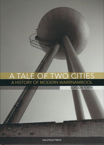 Warrnambool and District Historical Society Inc.
Book, A tale of two cities: a History of Modern Warrnambool, 2015
This book is the story of modern Warrnambool, describing aspects of the city from the 1980s to 2015. It looks at such topics as religion, law, population, housing, infrastructure, employment, industry, health, education and politics. The author, Gordon Forth, was formerly a lecturer in the Faculties of Education and Arts and the Director of the Centre for Regional Development at Deakin University in Warrnambool. He has written and edited a number of books dealing with Warrnambool and district history. Mark Rashleigh, responsible for the design and lay-out of the book and many of the photographs, was a lecturer in visual communication and graphic design in the Faculty of Arts at Deakin University and is now involved with the Warrnambool and District Historical Society in the preparation and cataloguing of historical photographs.The book is of some importance as it is the only comprehensive study of Warrnambool over the past 30 years and complements ‘By These We Flourish’, the story of Warrnambool’s people, places and events up to the 1980s. It is will be of great interest to readers in general and researchers in particularThis is a hardcover book of 320 pages. The dust cover is multi-coloured (black, white and gold) with an image of the water tower at the former Fletcher Jones Factory site on the front cover and an image of the Warrnambool Breakwater on the back cover. The hard cover book has the same colouring and images as the dust cover.Front covers – ‘A Tale of Two Cities – A History of Modern Warrnambool’, ‘Gordon Forth’, ‘Halstead Press’ Spines – ‘A Tale of Two Cities – A History of Modern Warrnambool’, ‘Forth’, ‘Halstead’ Back Covers – ISBN number and code warrnambool, gordon forth, a history of modern warrnambool, a tale of two cities -
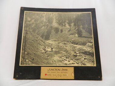 Kiewa Valley Historical Society
Photo of Junction Dam - Kiewa Hydro Electric Scheme, Junction Dam, Kiewa Hydro Electric Scheme, Photo taken 10th Feb. 1940
The Junction Dam was built by the State Electricity Commission of Victoria as part of the Kiewa Hydro Electric Scheme. This photo show its construction in February 1940. The State Electricity Commission of Victoria were the employers of the Kiewa Hydro Scheme. The work included building dams, power stations and the infrastructure for the work and their employees. Mt Beauty and Bogong village were the places where this scheme was built and where this photo shows part of its construction being Power Station 3. Originally there were 3 Hydro stations built from the 1930's onwards. The scheme finished being built in 1960 and is the biggest Hydro electricity scheme in Victoria.This photo has Historic significance due to Junction Dam built as part of the Kiewa Hydro Electric Scheme by the State Electricity Commission of Victoria. This photo shows its construction in February 1940. This is a black and white photo of Junction Dam viewed from upstream. Junction Dam was part of the Kiewa Hydro Electric Scheme. The picture shows piles of wood and pipes, crane, trucks and a shed on the cleared ground. The photo is mounted on 3 ply wood, painted black.kiewa hydro electric scheme. junction dam. s.e.c.v.. -
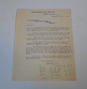 Bendigo Historical Society Inc.
Letter - Kelly and Allsop collection: Amalgamated Hill End
Situated 150 miles from Sydney and 50 miles from Bathurst, Hawkin's Hill mining leases had produced good returns in the 1860's and 70's. However, a lack of working capital meant that many of the mines operated by up to 17 different companies petered out. About 1886 efforts were made to consolidate these claims but insufficient funding could be found. With the renewal of an offer of a government subsidy and the sale of shares, has allowed the purchase of these old claims and their infrastructure. Exploration has shown that these old mines still contained payable amounts of gold. Thus the formation of the Amalgamated Hill End Company.Typewritten letter dated 2nd February 1911. The letter is from the Amalgamated Hill End Ltd signed by the secretary, addressed to M.P. Kelly Esq. stock and share broker, Bendigo. The letter advises of the upcoming float on the stock market of the Amalgamated Hill End Mines. The float is for 500,000 shares at four shilling each. Copies of the prospectus will be sent once available.A lot of sums in pencil on front and backamalgamated hill end mine, shares -
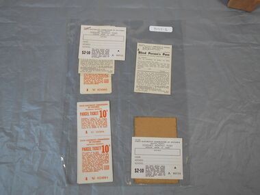 Bendigo Historical Society Inc.
Document - Various passes and tickets
Sandhurst and Electric Tramways Company introduced the first trams to Bendigo in June 1890. These were battery operated trams but it soon became obvious that the battery life was unable to copy with Bendigo's hilly terrain. The trams were converted to steam in 1892. In 1899 the tramways were sold to the Electric Supply Company of Victoria and in 1903 the trams were converted to electricity. After WW1 the SEC was formed and took over the running of the trams. With the increased usage of cars, patronage of the trams began to drop off after WW2. In 1972 the tramways closed as a commuter service. The Bendigo trust then restored trams and infrastructure and began the tourist/talking trams.State Electricity Commission of Victoria Provincial Tramways: 2 x single parcel tickets Nos 024004 and 024005, 1 x single Scholars Monthly ticket, 1 x single Blind persons pass, 1 x transfer with image of by holding sign with quote "Electricity makes life easier!". Also stapled together 1 x Scholars Monthly ticket, 1 x Blind persons pass and 2 x parcel tickets. Parcel tickets have orange print on thin paper. Monthly ticket and Blind persons pass have black print on cardboard. Transfer is on original brown cardboard.provincial tramways, tramways, tickets, passes, electricity -
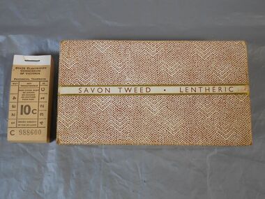 Bendigo Historical Society Inc.
Administrative record - Tramways student passes
Sandhurst and Electric Tramways Company introduced the first trams to Bendigo in June 1890. These were battery operated trams but it soon became obvious that the battery life was unable to copy with Bendigo's hilly terrain. The trams were converted to steam in 1892. In 1899 the tramways were sold to the Electric Supply Company of Victoria and in 1903 the trams were converted to electricity. After WW1 the SEC was formed and took over the running of the trams. With the increased usage of cars, patronage of the trams began to drop off after WW2. In 1972 the tramways closed as a commuter service. The Bendigo trust then restored trams and infrastructure and began the tourist/talking trams.State Electricity Commission of Victoria Provincial Tramways: student passes One box containing various types of tram tickets. Bottom of box is red. Top of box has a mottled pattern with a stripe across the length with the words "SAVON TWEED LENTHERIC". 1 separate bundle of 10c paper tickets with cardboard backing and whitestripe where tickets are stapled together. Tickets are a beige color with black print. Bottom of box has a blue sticker with white typeface - "JW Jones Chemist Hargreaves St. Bendigo" 13/6 is written in the middle of this sticker with pencil.On back of separate ticket bundle is blue pen with OCT 1972 crossed out and 16.4.1972 Trams Finishedprovincial tramways, tramways, tickets, passes, electricity -
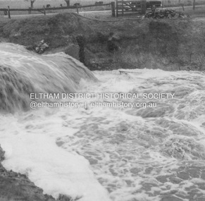
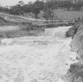
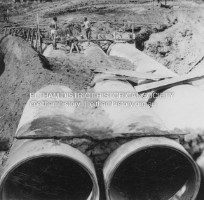
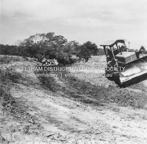
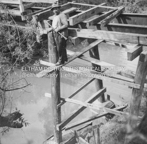
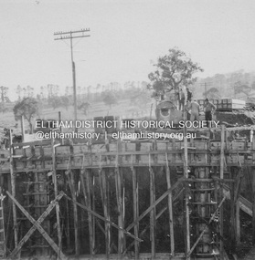 Eltham District Historical Society Inc
Album - Photograph, J.A. McDonald, Dixons Creek Road, June 1957
Bridge over Dixons Creek Job 56FD330 June 1957 Formwork for Dixons Creek pier completed Advertising (1957, January 19). The Argus (Melbourne, Vic. : 1848 - 1957), p. 33 (Col. 9). Retrieved August 24, 2022, from http://nla.gov.au/nla.news-article71777065 SHIRE OF ELTHAM. Loan No. 27.-Notice of Intention to Borrow Sum of £ 15,000 for Permanent Works and Undertakings. - Notice is hereby given, that the Council of the Shire of Eltham proposes to borrow the sum of £15,000 on the credit of the municipal revenues of the president, councillors, and ratepayers for the said shire, such sum to be raised by the Issue of debentures in accordance with the provisions of the Local Government Acts. 1. Maximum rate of interest that may be paid is £5/10/ per cent, per annum. 2. The purposes for which the loan is to be applied are: Construction of Sanitary Conveniences at Shire Office, Council's contribution towards costs of Dixons Creek Bridge, Construction of Mt. Pleasant rd., Construction of Cherry Tree rd. 3. The period of the loan shall be 10 years. 4. Moneys borrowed will be repayable by providing out of the Municipal Fund twenty half-yearly instalments of approximately £985/1/6 each, including principal and interest on the first day of October and the first day of April during the currency of the loan. The first Instalment shall be payable on the first day of October 1957. 5. Such moneys shall be repayable at the Commercial Bank of Australia Limited, Melbourne, or at the Council's bankers for the time being in Melbourne. The plans and specifications and the estimates of the costs of the proposed works and a statement showing the proposed expenditure of the moneys to be borrowed are open for inspection at the Shire Office, Eltham. R. J. HAM. Shire Secretary.Record of various Shire of Eltham infrastructure works undertaken during the period of 1952-1962 involving bridge and road reconstruction projects, sometimes with Eltham Shire Council Project Reference numbers quoted. It was during this period that a number of significant improvements were made to roads and new bridges constructed within the shire that remain in place as of present day (2022). In many situations, the photos provide a tangible visible record of infrastructure that existed throughout the early days of the Shire. The album was put together by or under the direction of the Shire Engineer, J.A. McDonald.infrastructure, road construction, shire of eltham, bridge construction, dixons creek bridge, dixon's creek road, 1957-06 -
 Eltham District Historical Society Inc
Album - Photograph, J.A. McDonald, Dixons Creek Road, 21 Oct. 1953
Scour on Dixons Creek Road 21st October 1953Record of various Shire of Eltham infrastructure works undertaken during the period of 1952-1962 involving bridge and road reconstruction projects, sometimes with Eltham Shire Council Project Reference numbers quoted. It was during this period that a number of significant improvements were made to roads and new bridges constructed within the shire that remain in place as of present day (2022). In many situations, the photos provide a tangible visible record of infrastructure that existed throughout the early days of the Shire. The album was put together by or under the direction of the Shire Engineer, J.A. McDonald.infrastructure, road construction, shire of eltham, bridge construction, dixons creek bridge, dixon's creek road, 1953-10-21 -
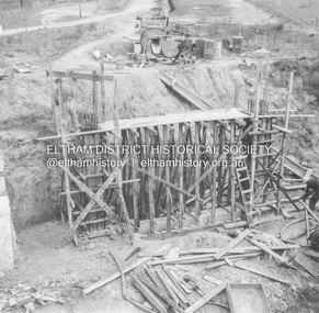
 Eltham District Historical Society Inc
Album - Photograph, J.A. McDonald, Dixons Creek Road, June 1957
Dixons Creek Road P. Morris – Contractor Dixons Creek (North) abutment 1957 Advertising (1957, January 19). The Argus (Melbourne, Vic. : 1848 - 1957), p. 33 (Col. 9). Retrieved August 24, 2022, from http://nla.gov.au/nla.news-article71777065 SHIRE OF ELTHAM. Loan No. 27.-Notice of Intention to Borrow Sum of £ 15,000 for Permanent Works and Undertakings. - Notice is hereby given, that the Council of the Shire of Eltham proposes to borrow the sum of £15,000 on the credit of the municipal revenues of the president, councillors, and ratepayers for the said shire, such sum to be raised by the Issue of debentures in accordance with the provisions of the Local Government Acts. 1. Maximum rate of interest that may be paid is £5/10/ per cent, per annum. 2. The purposes for which the loan is to be applied are: Construction of Sanitary Conveniences at Shire Office, Council's contribution towards costs of Dixons Creek Bridge, Construction of Mt. Pleasant rd., Construction of Cherry Tree rd. 3. The period of the loan shall be 10 years. 4. Moneys borrowed will be repayable by providing out of the Municipal Fund twenty half-yearly instalments of approximately £985/1/6 each, including principal and interest on the first day of October and the first day of April during the currency of the loan. The first Instalment shall be payable on the first day of October 1957. 5. Such moneys shall be repayable at the Commercial Bank of Australia Limited, Melbourne, or at the Council's bankers for the time being in Melbourne. The plans and specifications and the estimates of the costs of the proposed works and a statement showing the proposed expenditure of the moneys to be borrowed are open for inspection at the Shire Office, Eltham. R. J. HAM. Shire Secretary.Record of various Shire of Eltham infrastructure works undertaken during the period of 1952-1962 involving bridge and road reconstruction projects, sometimes with Eltham Shire Council Project Reference numbers quoted. It was during this period that a number of significant improvements were made to roads and new bridges constructed within the shire that remain in place as of present day (2022). In many situations, the photos provide a tangible visible record of infrastructure that existed throughout the early days of the Shire. The album was put together by or under the direction of the Shire Engineer, J.A. McDonald.infrastructure, road construction, shire of eltham, bridge construction, dixons creek bridge, dixon's creek road, 1957-06 -
 Eltham District Historical Society Inc
Album - Photograph, J.A. McDonald, Dixons Creek Road, June 1957
Dixons Creek Road Bridge over Dixons Creek – 56FD330 June 1957 Dixons Creek pier forming columns and beam Advertising (1957, January 19). The Argus (Melbourne, Vic. : 1848 - 1957), p. 33 (Col. 9). Retrieved August 24, 2022, from http://nla.gov.au/nla.news-article71777065 SHIRE OF ELTHAM. Loan No. 27.-Notice of Intention to Borrow Sum of £ 15,000 for Permanent Works and Undertakings. - Notice is hereby given, that the Council of the Shire of Eltham proposes to borrow the sum of £15,000 on the credit of the municipal revenues of the president, councillors, and ratepayers for the said shire, such sum to be raised by the Issue of debentures in accordance with the provisions of the Local Government Acts. 1. Maximum rate of interest that may be paid is £5/10/ per cent, per annum. 2. The purposes for which the loan is to be applied are: Construction of Sanitary Conveniences at Shire Office, Council's contribution towards costs of Dixons Creek Bridge, Construction of Mt. Pleasant rd., Construction of Cherry Tree rd. 3. The period of the loan shall be 10 years. 4. Moneys borrowed will be repayable by providing out of the Municipal Fund twenty half-yearly instalments of approximately £985/1/6 each, including principal and interest on the first day of October and the first day of April during the currency of the loan. The first Instalment shall be payable on the first day of October 1957. 5. Such moneys shall be repayable at the Commercial Bank of Australia Limited, Melbourne, or at the Council's bankers for the time being in Melbourne. The plans and specifications and the estimates of the costs of the proposed works and a statement showing the proposed expenditure of the moneys to be borrowed are open for inspection at the Shire Office, Eltham. R. J. HAM. Shire Secretary.Record of various Shire of Eltham infrastructure works undertaken during the period of 1952-1962 involving bridge and road reconstruction projects, sometimes with Eltham Shire Council Project Reference numbers quoted. It was during this period that a number of significant improvements were made to roads and new bridges constructed within the shire that remain in place as of present day (2022). In many situations, the photos provide a tangible visible record of infrastructure that existed throughout the early days of the Shire. The album was put together by or under the direction of the Shire Engineer, J.A. McDonald.infrastructure, road construction, shire of eltham, bridge construction, dixons creek bridge, dixon's creek road, 1957-06 -
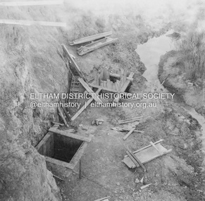
 Eltham District Historical Society Inc
Album - Photograph, J.A. McDonald, Eltham, Susan Street, 6 Mar. 1959
Contractor Wolf and culvert March 6, 1959 Looking eastwardRecord of various Shire of Eltham infrastructure works undertaken during the period of 1952-1962 involving bridge and road reconstruction projects, sometimes with Eltham Shire Council Project Reference numbers quoted. It was during this period that a number of significant improvements were made to roads and new bridges constructed within the shire that remain in place as of present day (2022). In many situations, the photos provide a tangible visible record of infrastructure that existed throughout the early days of the Shire. The album was put together by or under the direction of the Shire Engineer, J.A. McDonald.infrastructure, road construction, shire of eltham, bridge construction, 1959-03-06, eltham, susan street -
 Eltham District Historical Society Inc
Album - Photograph, J.A. McDonald, Eltham, Susan Street, Mar. 1959
Outlet drain Contractor WoodRecord of various Shire of Eltham infrastructure works undertaken during the period of 1952-1962 involving bridge and road reconstruction projects, sometimes with Eltham Shire Council Project Reference numbers quoted. It was during this period that a number of significant improvements were made to roads and new bridges constructed within the shire that remain in place as of present day (2022). In many situations, the photos provide a tangible visible record of infrastructure that existed throughout the early days of the Shire. The album was put together by or under the direction of the Shire Engineer, J.A. McDonald.infrastructure, road construction, shire of eltham, bridge construction, eltham, susan street, 1959-03 -
 Eltham District Historical Society Inc
Album - Photograph, J.A. McDonald, General; Albion Street and Eltham-Yarra Glen Road, Oct. 1955
Eltham-Yarra Glen Road Lower Plenty Footbridge October 1955 (Jolly)Record of various Shire of Eltham infrastructure works undertaken during the period of 1952-1962 involving bridge and road reconstruction projects, sometimes with Eltham Shire Council Project Reference numbers quoted. It was during this period that a number of significant improvements were made to roads and new bridges constructed within the shire that remain in place as of present day (2022). In many situations, the photos provide a tangible visible record of infrastructure that existed throughout the early days of the Shire. The album was put together by or under the direction of the Shire Engineer, J.A. McDonald.infrastructure, road construction, shire of eltham, 1955-10, bridge construction, eltham-yarra glen road, lower plenty footbridge