Showing 10092 items matching "demolished"
-
 Buninyong & District Historical Society
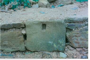
Photograph - Original Photograph, C J Brooks, Individual Sandstone block showing hole to support wooden strut, in reconstruction of wall, at 405 Learmonth St. Buninyong, July 1995
Stone of which wall is constructed is believed to have been used in the construction of Jamieson's Buninyong Inn, built for Margaret Jamieson starting about 1853. She owned the earlier Buninyong Inn which impinged on they surveyed Learmonth St. and was demolished. Margaret died in 1854 before the building was completed by her son, who built the third Buninyong Inn on the corner of Learmonth and Warrenheip. The two story hotel was tenented for a while, then bought by Dr. Sparling who demolished it.Colour photo, bottom section of wall, showing individual Sandstone block with hole to support wooden strut, in reconstruction of wall, at 405 Learmonth St. Buninyongbuninyong, jamieson, sparling, buninyong inn, wall, sandstone -
 Buninyong & District Historical Society
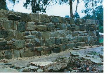
Photograph - Original Photograph, C J Brooks, Sandstone wall after rebuilding at 405 Learmonth St. Buninyong, July 1995
Stone of which wall is constructed is believed to have been used in the construction of Jamieson's Buninyong Inn, built for Margaret Jamieson starting about 1853. She owned the earlier Buninyong Inn which impinged on they surveyed Learmonth St. and was demolished. Margaret died in 1854 before the building was completed by her son, who built the third Buninyong Inn on the corner of Learmonth and Warrenheip. The two story hotel was tenented for a while, then bought by Dr. Sparling who demolished it.Colour photo, Sandstone wall after rebuilding at 405 Learmonth St. Buninyongbuninyong, jamieson, sparling, buninyong inn, wall, sandstone -
 Orbost & District Historical Society
black and white photograph, 1960s - 1970s
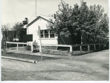
This photograph shows the former Orbost Police Station in Wolseley Street before it was demolished and a new larger brick building was built behind it in Lawson Lane - late 1980s.This is a pictorial record of a significant community building no longer existing.A large black / white photograph of the Orbost township police station. It is a weatherboard building surrounded by trees. A sign "POLICE" is hanging from a pole.on back - " Orbost Police Station in Wolseley Street, Donated by Debbie Hall 31/8/94"orbost-police-station -
 Ringwood and District Historical Society
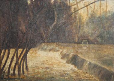
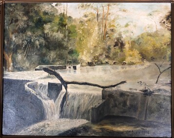
Painting, "Busch's Weir" - Oil on canvas by Hermann Otto ("Hof") Busch (1880-1960), 1953
In the 1930s, Hermann Busch constructed a concrete wall across Dandenong Creek, forming "Busch's Weir" on his Bayswater property, "Waldheim". The weir wall was demolished in the 1960s.One of two paintings of weir across Dandenong Creek, mounted in beveled edge wooden frame with ornate corner moldings. (See Reg #4856B for other of two paintings in the pair)Hof Busch 1953 -
 Ringwood and District Historical Society
Painting, "Busch's Weir" - Oil on canvas by Hermann Otto ("Hof") Busch (1880-1960), 1953
In the 1930s, Hermann Busch constructed a concrete wall across Dandenong Creek, forming "Busch's Weir" on his Bayswater property, "Waldheim". The weir wall was demolished in the 1960s.One of two paintings of weir across Dandenong Creek, mounted in beveled edge wooden frame with ornate corner moldings. (See Reg #4856 for other of two paintings in the pair)Hof Busch 1953 -
 Glen Eira Historical Society
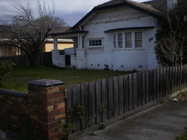
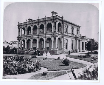
Photograph - Hawthorn Road, 464, Caulfield South
9 digital photographs of a group of houses in Hawthorn Road Caulfield South that are about to be demolished for a new property development Photographer Claire Barton 30/07/2010hawthorn road, caulfield south, houses -
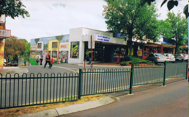
![Photograph - Photograph Collection, Greensborough: Mural on Vickers Way [off Main Street], 2010c](/media/collectors/4f729f5697f83e03086015b8/items/6607af991466534a78efc8cc/item-media/6607afe41466534a78efcce9/item-fit-380x285.jpg) Greensborough Historical Society
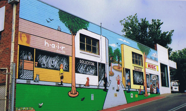
Greensborough Historical SocietyPhotograph - Photograph Collection, Greensborough: Mural on Vickers Way [off Main Street], 2010c
Main Street Greensborough. Mural on Vickers Way (lane between Main Street and carpark near old pool). The mural was demolished as part of the redevelopment on Main Street.2 colour photographsmain street greensborough, vickers way, murals -
 Greensborough Historical Society
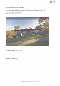
Article and Photograph, Crystal Clean Car Wash, 01/08/2019
Crystal Clean Bay car wash, 35 Sherbourne Road Briar Hill was demolished about 5 July 2019. The site is being redeveloped with residential units.1 page colour photograph and captioncrystal clean bay car wash, sherbourne road briar hill -
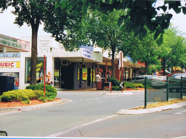
![Photograph - Digital image, Frank Solomon, Greensborough: Mural on Vickers Way [off Main Street], 04/06/2010](/media/collectors/4f729f5697f83e03086015b8/items/58c38e71d0ce9d27549a06d2/item-media/58c38ebbd0ce9d27549a1abd/item-fit-380x285.jpg) Greensborough Historical Society
Greensborough Historical SocietyPhotograph - Digital image, Frank Solomon, Greensborough: Mural on Vickers Way [off Main Street], 04/06/2010
Main Street Greensborough. Mural on Vickers Way (lane between Main Street and carpark near old pool). The mural was demolished as part of the redevelopment on Main Street.Digital copy of colour photographmain street greensborough, vickers way -
 Greensborough Historical Society
Photograph - Digital image, Frank Solomon, Greensborough: Mural on Vickers Way, 04/06/2010
Main Street Greensborough. Mural on Vickers Way (lane between Main Street and carpark near old pool). The mural was demolished as part of the redevelopment on Main Street.Digital copy of colour photographmain street greensborough, vickers way -
 Greensborough Historical Society
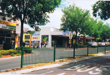
Photograph - Digital image, Frank Solomon, Greensborough: Main Street looking toward Vickers Way and mural, 04/06/2010
Main Street Greensborough. Mural on Vickers Way (lane between Main Street and carpark near old pool). The mural was demolished as part of the redevelopment on Main Street.Digital copy of colour photographmain street greensborough, vickers way -
 Greensborough Historical Society
Photograph - Digital image, Frank Solomon, Greensborough: Main Street looking toward Vickers Way and mural, 04/06/2010
Main Street Greensborough. Mural on Vickers Way (lane between Main Street and carpark near old pool). The mural was demolished as part of the redevelopment on Main Street.Digital copy of colour photographmain street greensborough, vickers way -
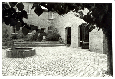 Federation University Historical Collection
Photograph - Photograph - Black and White, Former Ballarat Gaol Courtyard, Federation University SMM Campus
After the Ballarat Gaol was closed it was handed to the Ballarat School of Mines. The gaol cells were demolished, and sections of the former gaol walls were incorporated into the Amenities building. A bricked courtyard at in the grounds of the former Ballarat Gaol at Federation University SMB Campus. The open door leads to the cafeteria in the Amenities Building.ballarat school of mines, courtyard, amenities building, ballarat gaol, architectural feature -
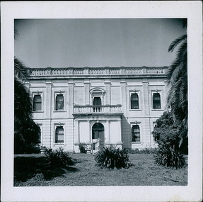
 St Kilda Historical Society
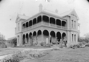
Photograph, Barham House (later called Mittagong) Grey St, West side, St Kilda, 1890s
Home of Richard Twentyman, Merchant, subsequently Judge Molesworth,5 people posed in front of the mansion wearing late Victorian clothes, , gardens, mansion was demolished c1940.black and white photograph, unmounted, good condition -
 Tatura Irrigation & Wartime Camps Museum
Photographs, McNamara's saleyards, c.1930
Photo probably taken from Commercial Hotel upstairs. McNamara's saleyards located in Hogan Street, north side west of Ross Street. Demolished c.1940Black and white photographs. 2 photographs -
 Uniting Church Archives - Synod of Victoria
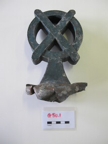
Roof finial
These finials were probably on the hall of St Andrew's Presbyterian church Ballarat and saved by the Rev Gary Douglas Jacobs when it was demolished. The hall was rebuilt in 1938-1959.G650.1 and G650.2 metal St Andrew's crosses roof finials. They have been painted blue. st andrew's presbyterian church ballarat, rev gary douglas jacobs -
 Whitehorse Historical Society Inc.
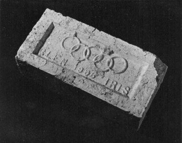
Memorabilia - Brick, 1956
The brick was used in the construction of a toilet block located behind the Blackburn Library and next to the railway line. it was donated by the City of Whitehorse after the toilet block was demolished in 1999.1956 Olympic Glen Iris cream brick'Glen 1956 Iris' with Olympic ringsbuildings, materials -
 Old Colonists' Association of Ballarat Inc.
Photographs, Clare Gervasoni, Renovation of Shops Associated with the Ballarat Old Colonist Hall, 2017, 04/08/2017
The Ballarat Old Colonists' Hall is on the site of the former Government Camp which governed the goldfield. The bluestone used in the foundation of the hall was reused from a building demolished on the site. A number of colour photographs showing the interiors of the Old Colonists' shops in Lydiard Street before the replacement of floorboards. ballarat old colonists' club, old colonists' association ballarat, old colonists' hall, bluestone, government camp, lydiard street north, shops -
 Department of Health and Human Services
Photograph, Coilsfield Estate in Essendon
The Coilsfield Estate, it was once found on the corners of Holms Road, York and Chester Streets in Moonee Ponds. It has been demolished. In 1964 the Essendon Hospital was constructed on this site. -
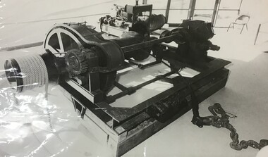 Queenscliffe Maritime Museum
Photograph - Motor Winch
The winch was relocated to the Queenscliff Maritime Museum when the shed was moved from Fishermen's Pier [when demolished] and relocated to its present location at the end of the Queenscliff Pier. The Lifeboat shed is an iconic building for the township of Queenscliff. It once was located on the now demolished Fishermen's Pier and relocated to the current Queenscliff Pier. However, the motor winch that used to be housed there is now in pride of place adjacent to the Queenscliffe lifeboat which it served for many years. Photograph of a motor winch from the 'Queenscliffe' Lifeboat Shed.queenscliffe lifeboat service, lifeboat shed, fishermen's pier, queenscliff pier -
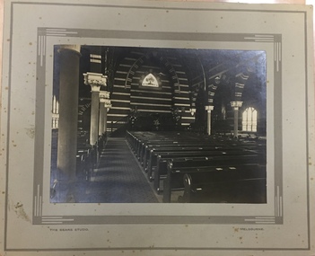 Kew Historical Society Inc
Photograph - Interior of the Kew Congregational Church, Walpole Street, The Sears Studio, 1920s
The first Kew Congregational Church in Walpole Street, was designed by Charles Vickers, and opened in 1860. The second church on the site, designed by the architect Charles Wharton was demolished in 1970s. Rare photograph of the interior decoration and layout of an important and now demolished church in KewBlack and white photograph, on card, featuring the interior of the Kew Congregational Church. Shows detail of pews, pulpit and ornate brickwork. Front: "The Sears Studio" "Melbourne" [printed on mounting board]. Reverse: "P. Inside of Kew Congregational Church" wapole street - kew (vic), congregational churches - kew (vic), chirch interiors -
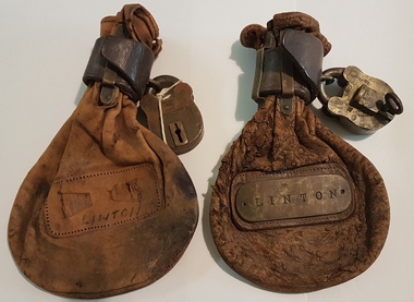 Linton and District Historical Society Inc
Railway Conductor's Bag, Railway Conductor's Bags
Used on Ballarat-Skipton railway line to carry money and tokens. Rescued from bonfire when Linton Station was demolished, by Fred Freestone. Donated to Society 1981.Two brown leather pouches. Bag 1 has brass plate which reads "Linton" (plate attached to square of leather stitched to bag). Bag 2 has the word "Linton" written in ink on front, where leather patch and brass plate used to be. Each bag has two brass loops at top, holding a leather strap which keeps the pouch closed. A brass padlock with a key is attached to the strap.Makers' marks: On padlock 1 and its key: "M 63" "J. Hubball Melbourne". On padlock 1: "VR". On padlock 2: " + " "S166" "59" "Chubb's Patent" "120 Queen Victoria St London" "Makers to Her Majesty" "120294" (=date?). On key for padlock 2: "Chubbs Patent" "London" "VR".railways, transport, conductor's bags -
 Buninyong Visitor Information Centre
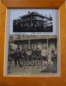
Photograph - Photograph, framed, Buninyong Hotel
Early images of the now demolished Buninyong Hotel which was located on the southwest corner of Warrenheip and Learmonth Streets, where the RSL Hall and commemorative park are now located. Two images of the Buninyong Hotel set in a wooden frame. 1. Buninyong Hotel, Daniel Phelan, Proprietor Cut out photocopy of the building. 2. Newspaper cutting of photograph of cyclists posing in front of the Buninyong Hotel in 1905, prior to the National Road Cycling Championships.buninyong, hotels, cycling -
 Linton and District Historical Society Inc
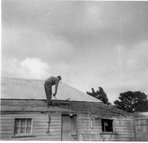
Photograph, Ching brothers' home
House in Clyde Street, formerly Di Piazza's, last lived in by bachelor brothers Bill and Les Ching, 1980s-1990s. Cameron Ching shown on roof demolishing it.Black and white photograph of rear view house with a person bent over standing on roof.ching family, cameron ching, di piazza, buildings, houses -
 Stawell Historical Society Inc
Photograph, "Oban" House with ladies and gentleman
Lady and gentleman standing on garden pathway in front of home and younger girl standing on verandah. Note on left behind building is the now demolished kitchen/servants area. stawell houses -
 Uniting Church Archives - Synod of Victoria
Photograph, undated
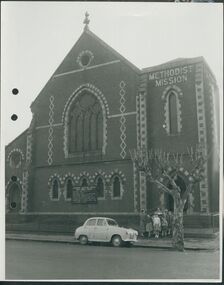
The Gipps Street Wesleyan Methodist Church of 1874 and the adjoining school hall, were built in the Collingwood Flat area - one of the municipality's poorest areas. In 1903, the Collingwood Methodist Mission was established with its headquarters in the Gipps Street Church. Six Methodist Missions were created in inner Melbourne. Three churches were operated by the Collingwood Mission. They were: Sackville Street Collingwood, Elizabeth Street, North Richmond (demolished), and Gipps Street Collingwood (demolished). The Mission operated until approximately 1930.B & W exterior view of the Gipps St. Collingwood Methodist Church. The image is a street view of a group of children and an adult standing in front of the brick church.gipps st. methodist church, les gorrie, collingwood mission -
 Eltham District Historical Society Inc
Photograph - Aerial Photograph, Intersection of Main Road and Bridge Street, c.1995
View of Main Road from Henry Street to Brougham Street across to the Diamond Creek showing the Eltham Shire Offices (demolished 1996), the Eltham Library (opened 1994)aerial photo, alistair knox park, bridge street, brougham street, central park, diamond creek (creek), eltham, eltham community centre, eltham courthouse, eltham justice precinct, eltham living and learning, franklin street, henry street, local history centre, main road -
 Phillip Island and District Historical Society Inc.
Photograph, Innishowen, 1978/9
Innishowen - home of William Harbison from 1868. Bought by Gliddon Family in 1911 and demolished in 1976 by owner G Gliddon. Present photograph of painting taken 1978/1979Innishowen - the home of William Harbison who owned most of the south western section of Phillip Island from 1868. Coloured photograph of painting of Innishowen showing house and garden. Green roofing iron.local history, photographs, buildings - historical, coloured photograph, john cook, innishowen, ventnor, phillip island, harbison -
 Greensborough Historical Society
Photograph - Digital image, Frank Solomon, Small shop corner Grimshaw and Main Streets Greensborough 2, 04/06/2010
Small shop corner Grimshaw and Howard Streets Greensborough (front view). Now demolished. This building was the former office of John Cecil Jessop, known locally as 'Jessop's Corner'.A record of the changing face of Greensborough.Digital copy of colour photographgrimshaw street greensborough