Showing 3626 items
matching landscape
-
 Glen Eira Historical Society
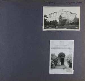
Album - Album page, Maysbury, Maysbury Avenue, Circa 1972
This photograph is part of the Caulfield Historical Album 1972. This album was created in approximately 1972 as part of a project by the Caulfield Historical Society to assist in identifying buildings worthy of preservation. The album is related to a Survey the Caulfield Historical Society developed in collaboration with the National Trust of Australia (Victoria) and Caulfield City Council to identify historic buildings within the City of Caulfield that warranted the protection of a National Trust Classification. Principal photographer thought to be Trevor Hart, member of Caulfield Historical Society. Most photographs were taken between 1966-1972 with a small number of photographs being older and from unknown sources. All photographs are black and white except where stated, with 386 photographs over 198 pages. Page 132 of Photograph Album with two photographs (one landscape, one portrait) of "Maysbury".Handwritten: "Maysbury" Maysbury Street/Avenue [top right] / 1972 Neg 47 [under top photo] / 132 [bottom right]trevor hart, windows, victorian, 1880's, maysbury, maysbury mansions, flats, decorative brackets, double storey, italianate, cast iron stair balustrading, cast iron balustrading, bay window, protruding rooms, bluestone fence, elsternwick, maysbury avenue, mansion, victorian style, arches, entrances -
 Glen Eira Historical Society
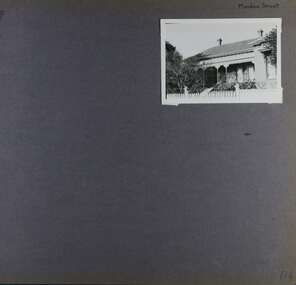
Album - Album page, Meadow Street, Circa 1972
This photograph is part of the Caulfield Historical Album 1972. This album was created in approximately 1972 as part of a project by the Caulfield Historical Society to assist in identifying buildings worthy of preservation. The album is related to a Survey the Caulfield Historical Society developed in collaboration with the National Trust of Australia (Victoria) and Caulfield City Council to identify historic buildings within the City of Caulfield that warranted the protection of a National Trust Classification. Principal photographer thought to be Trevor Hart, member of Caulfield Historical Society. Most photographs were taken between 1966-1972 with a small number of photographs being older and from unknown sources. All photographs are black and white except where stated, with 386 photographs over 198 pages. Page 134 of Photograph Album with one landscape photograph of a Victorian house on Meadow Street.Handwritten: Meadow Street [top right] / 134 [bottom right]trevor hart, east st kilda, decorative brackets, picket fence, slate roof, chimneys, garden, cast iron columns, cast iron frieze, meadow street, st kilda east, caulfield, victorian style, cast iron work, verandahs -
 Glen Eira Historical Society
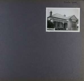
Album - Album page, Munster Avenue, Circa 1972
This photograph is part of the Caulfield Historical Album 1972. This album was created in approximately 1972 as part of a project by the Caulfield Historical Society to assist in identifying buildings worthy of preservation. The album is related to a Survey the Caulfield Historical Society developed in collaboration with the National Trust of Australia (Victoria) and Caulfield City Council to identify historic buildings within the City of Caulfield that warranted the protection of a National Trust Classification. Principal photographer thought to be Trevor Hart, member of Caulfield Historical Society. Most photographs were taken between 1966-1972 with a small number of photographs being older and from unknown sources. All photographs are black and white except where stated, with 386 photographs over 198 pages. This house continues to occupy the property at 5 Munster Avenue Carnegie (Google map image capture Feb 2019).Page 136 of Photograph Album with one landscape photograph of an Edwardian house on Munster Avenue.Handwritten: Munster Street / Avenue [top right] / 136 [bottom right]trevor hart, garden, verandah, bull nosed verandah, edwardian, coloured glass, corrugated iron roof, bay window, gable, chimneys, porch, munster avenue, carnegie, box bay window, weatherboards, cast iron work, timber houses -
 Glen Eira Historical Society
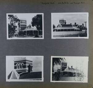
Album - Album page, Fairfield Hall, 225 North Road, Circa 1972
This photograph is part of the Caulfield Historical Album 1972. This album was created in approximately 1972 as part of a project by the Caulfield Historical Society to assist in identifying buildings worthy of preservation. The album is related to a Survey the Caulfield Historical Society developed in collaboration with the National Trust of Australia (Victoria) and Caulfield City Council to identify historic buildings within the City of Caulfield that warranted the protection of a National Trust Classification. Principal photographer thought to be Trevor Hart, member of Caulfield Historical Society. Most photographs were taken between 1966-1972 with a small number of photographs being older and from unknown sources. All photographs are black and white except where stated, with 386 photographs over 198 pages. Glen Eira Heritage Management Plan 1996 by Andrew Ward https://www.gleneira.vic.gov.au/media/4777/heritage_mment_plan_vol_3b.pdf (as of 27/01/2021) - p90 An imposing single storeyed Italianate bi-chromatic brick villa with three staged tower surmounting the entry and facetted corner bay with conical roof. White tuckpointed black body bricks are relieved with reds and stucco work. Gable ends are fretted and there is a concave cast iron verandah to the principal elevations.Victorian Heritage Database (as of 27/10/2020) - HO49 225 North Road Caulfield South https://vhd.heritagecouncil.vic.gov.au/places/42426 "Maniar" (?) is a substantial late Victorian Italianate villa with tower and extensive grounds built for Frederick Curwan, an inspector of the National Bank, in 1890. It is aesthetically and historically important. An imposing single storeyed ltalianate bi-chromatic brick villa with three staged tower surmounting the entry and facetted comer bay with conical roof. White tuckpointed black body bricks are relieved with reds and stucco work. Gable ends are fretted and there is a concave cast iron verandah to the principal elevations. It is aesthetically important as an imposing and substantially intact villa residence demonstrating the changing architectural fashions of the 1890's, evidenced by the use of face brickwork and fretted gables in the Queen Anne manner. It is historically important for the manner in which it demonstrates the lifestyle to which a businessman could aspire during the boom period.Page 150 of Photograph Album with four landscape photographs of Fairfield Hall on North Road.Handwritten: "Fairfield Hall" 225 North Rd cnr Younger Ave [top right] / 150 [bottom right]trevor hart, jenny o'donnell, verandah, porch, tower house, tower, mansion, three storey tower, bichromatic brickwork, fairfield hall, 1890's, george jobbins, conical roofed projecting corner bay, conical roofed bay, timber ceilings, north road, younger avenue, frederick wallis curwan, curwan, italianate, queen anne, australian homestead, arched windows, curved windows, columned parapet, return verandah, fairfield estate, fairfield street, slate roofed, red brick, polychrome bricks, victorian style, cast iron work, caulfield south, maniar, house names -
 Glen Eira Historical Society
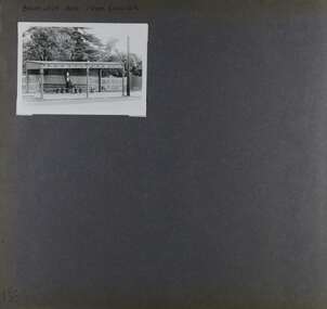
Album - Album page, Balaclava Road Tram Shelter, Circa 1972
This photograph is part of the Caulfield Historical Album 1972. This album was created in approximately 1972 as part of a project by the Caulfield Historical Society to assist in identifying buildings worthy of preservation. The album is related to a Survey the Caulfield Historical Society developed in collaboration with the National Trust of Australia (Victoria) and Caulfield City Council to identify historic buildings within the City of Caulfield that warranted the protection of a National Trust Classification. Principal photographer thought to be Trevor Hart, member of Caulfield Historical Society. Most photographs were taken between 1966-1972 with a small number of photographs being older and from unknown sources. All photographs are black and white except where stated, with 386 photographs over 198 pages. From Victorian Heritage Database citation H0174 TRAM VERANDAH SHELTER CORNER BALACLAVA AND ORRONG ROADS CAULFIELD NORTH - Vic Heritage Register https://vhd.heritagecouncil.vic.gov.au/places/2721 (as at 28/10/2020) The waiting shelter at the corner of Balaclava Road and Orrong Road, Caulfield was constructed in 1916/17 for the Prahran and Malvern Tramways Trust and is one of only three remaining tram shelters in Melbourne designed in the form of a verandah. The shelter has a corrugated iron roof fixed to an angle iron roof frame. The roof, which extends in the form of a skillion over the pavement, is supported on three squared, chamfered timber posts at the rear and three cast iron reeded columns with round bases and Corinthian capitals at the front. (The columns are hollow and function as downpipes, with rainwater discharging from the verandah roof, through the columns and under the ground). The shelter has a rinceau pattern frieze along the road frontage with centrally placed shield motif (which does not contain a coat of arms). The side and rear panels are lined with ripple iron and the upper panel at the rear is lattice work. The shelter has two timber slatted bench seats.From Victorian Heritage Database citation for H0174 TRAM VERANDAH SHELTER CORNER BALACLAVA AND ORRONG ROADS CAULFIELD NORTH - Vic Heritage Register https://vhd.heritagecouncil.vic.gov.au/places/2721 (as at 28/10/2020) How is it significant? The waiting shelter at the corner of Balaclava Road and Orrong Road, Caulfield is of historical and architectural significance to the State of Victoria. Why is it significant? The waiting shelter is of historical significance for its association with the development of the suburban (electric) tram network which assisted the expansion of Melbourne as a suburban metropolis. It is also of historical significance for its connection with the Prahran & Malvern Tramways Trust. The Prahran & Malvern Tramways Trust (1907-1920) was the first municipal electric tramway in Melbourne, becoming the largest and most successful of all the municipal tramway trusts. Its services played a key role in facilitating suburban expansion and the development of the southern and eastern suburbs. The growth of tramways was one of the greatest municipal developments in Victoria during the first decade of the twentieth century. The waiting shelter is an important remnant of this period of Melbourne's transport history and a tangible reminder of the Prahran & Malvern Tramways Trust. The shelter indicates the extent of the Prahran & Malvern tram network. The waiting shelter at corner of Balaclava Road and Orrong Road, Caulfield is one of only three remaining tram shelters in Melbourne designed in the form of a verandah. The waiting shelter is of architectural significance for the distinctive design and construction which is unique to the Prahran & Malvern Tramway Trust tram network. The shelter was designed by notable Melbourne architect Leonard J. Flannagan (1864-1946). Flannagan was responsible for a number of buildings for the Prahran and Malvern Tramways Trust including the early waiting shelter at the junction of Dandenong Road and Hawthorn Road, Caulfield, and sections of the tram depot at Malvern, and also designed a depot for the Hawthorn Tramways Trust. The waiting shelter, a conservative design influenced by Victorian architecture, is based on the Melbourne City Council late 19th century standard cast iron verandah. It is of significance as an intact example of the cast iron type shelter and for its detail, including Corinthian columns and a 'rinceau' pattern cast-iron frieze. The shelter is largely in keeping with the original design and retains its integrity. The cast iron waiting shelter is also of significance as an unusual example of early twentieth century street architecture. Page 155 of Photograph Album with one landscape photograph of a tram shelter on Balaclava Road.Handwritten: BALACLAVA ROAD TRAM SHELTER [top] / 155 [bottom left]trevor hart, verandah, garden, grimwade house, grimwade, orrong road, balaclava road, melbourne grammar, melbourne grammar junior school, mgs, m.g.s, school, tram shelter, waiting shelter, prahran & malvern tramway trust, leonard j. flannagan, cast iron verandah, cast iron type shelter, corinthian columns, 'rinceau' pattern cast-iron frieze, rinceau, cast iron frieze, victorian style, caulfield north, leonard flanagan, cast iron work, prahran and malvern tramways trust, trams -
 Glen Eira Historical Society
Album - Album page, Glen Huntly Road, Circa 1972
This photograph is part of the Caulfield Historical Album 1972. This album was created in approximately 1972 as part of a project by the Caulfield Historical Society to assist in identifying buildings worthy of preservation. The album is related to a Survey the Caulfield Historical Society developed in collaboration with the National Trust of Australia (Victoria) and Caulfield City Council to identify historic buildings within the City of Caulfield that warranted the protection of a National Trust Classification. Principal photographer thought to be Trevor Hart, member of Caulfield Historical Society. Most photographs were taken between 1966-1972 with a small number of photographs being older and from unknown sources. All photographs are black and white except where stated, with 386 photographs over 198 pages. From: Glen Eira Heritage Management Plan (1996) by Andrew Ward and Associates Moore's Buildings", were built in 1891 and comprising 5 shops. In 1888, Hugh Moore, a gentleman, subdivided his land in Glen Huntly Road, north side between Selwyn Street and St Georges Road into 27 lots, with a right of way separating them from his property "Glenmoore". The subdivision was known as the "Glenmoore Estate". Purchases of land included local builders Corkill, French and Pugh. Moore retained five lots and W.W. Jamieson bought lots 11 to 14. "Moore' s Buildings are locally important for their association with the early Elsternwick land owner, Hugh Moore, whose home, "Glenmoore", at 1 St.Georges Road (qv) survives. They recall Elsternwick's role in the Land Boom and survive as a most prominent row in the Glen Huntly Road shops, enhanced by the survival of the unpainted stuccoed surfaces to nos. 307-311. 287-289 Glen Huntly Road: contributory to HO72, Elsternwick Estate and Environs, City of Glen Eira.Page 63 of Photograph Album with one landscape photograph of retail shops (Moore's Buildings).Hand written: 287-289 Glen Huntly Road [under photo] / 63 [bottom left] trevor hart, shop, grocer, stuccoed, terrace, victorian terrace, protruding parapet, ornate render, hugh moore, 1890's, moore's buildings, glenmoore, glenmoore estate, shopping centres, milk bars, cars, victorian style, glen huntly road, glenhuntly road, elsternwick -
 Bendigo Historical Society Inc.
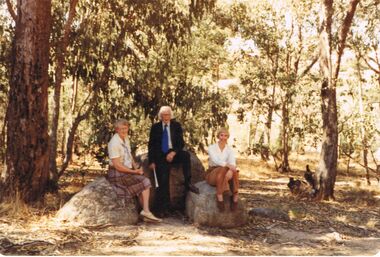
Photograph - COLOUR PHOTOGRAPH OF LANDSCAPE: PEOPLE
COLOUR PHOTOGRAPH OF landscape /3 people. Mrs Kingerley, Alec Stone, and Felicity Kingerley.photograph, person -
 Cockatoo History & Heritage Group
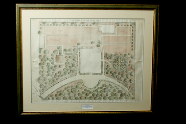
Landscape Plan, Providence House Cockatoo, 1930's
The Presbyterian Church owned three lots of land bounded by Pakenham Road and the northern side of Dorchester Road, between 1927 and 1964. Providence House opened in 1927 as a peaceful country rest home for “tired mothers” from the inner suburbs, and their children. It was also used, at different times, for kindergarten groups and in 1955 for a girls Bible Class for Easter “studies, fun and fellowship.”Cockatoo had several guest houses which took paying guests. Providence House did not charge fees, but is the best-documented of the large houses which provided accommodation.Framed landscape design plan under glass, with detailed plant listings. Original watercolourDonated by Victoria & Digby Newcombe 2003presbyterian church, rest home, landscape plan, garden design, cockatoo victoria, providence house, black n.c, -
 Victorian Interpretive Projects Inc.
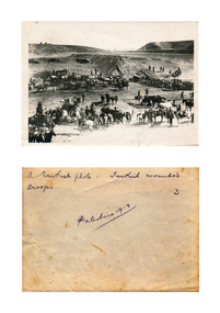
Photograph, Turkish Mounted Troops During World War One, 1918, 1918
Black and white photograph of a landscape with Turkish Mounted Troops During World War One.Verso: A Turkish photo. Turkish Mounted Troops. Palestine 1918world war, world war one, palestine, turks, turkish, mmm -
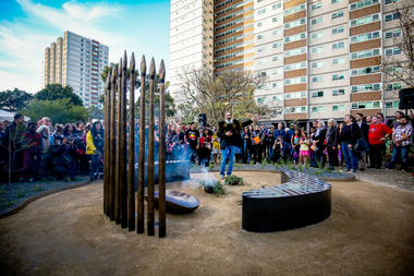 Yarra City Council
Artwork, other - Marker, Reko Rennie, Remember Me: Stolen Generations Marker, 2018
Kamilaroi artist Reko Rennie’s vision is an inclusive environment where people can sit and peacefully reflect on, mourn and acknowledge the deep trauma of the past, as well as connect with the ongoing strength and resilience of the Aboriginal community and support the process of healing. 'Remember Me' symbolises community resilience, identity and family. Positioned in a ceremonial ring, the seating and spears create a circle of gathering and remembrance within the park. In a contemporary and historical sense, the spear is an emblematic statement about struggle and adversity, and it is also an expression of identity and connection to land and culture.The 'Stolen Generations Marker, Remember Me', reflects the community’s wish to create a permanent tribute to the Stolen Generations and their families; a place of reflection and respectful commemoration. Integral to this is the surrounding garden with plants local to the area that have been re-introduced into the setting. Sited at the historically important Meeting Place in the heart of Aboriginal Fitzroy, the artwork honours not only the story of this place, but of all Aboriginal people who were taken away. This project was guided by the Stolen Generations Marker Steering Group and realised by Yarra City Council in partnership with the Victorian Government. Most importantly, it has received widespread grassroots community support. It was officially launched on the 20th anniversary of National Sorry Day (26 May 2018), which acknowledges the impact of the policies spanning more than 150 years of forcible removal of Aboriginal and Torres Strait Islander children from their families. On 26 May 1997 the landmark 'Bringing Them Home' report was tabled in Federal Parliament. The report was the result of a national inquiry that investigated the forced removal of Indigenous children from their families. This was a pivotal moment for many Stolen Generations. It was the first time the stories of forced removal were formally acknowledged by the Government and a recognition that these actions were inhumane. The impacts have been lifelong and intergenerational. A collection of bronze spears and a coolamon with accompanying seating, lighting and landscaping positioned in a ceremonial ring.stolen generations, fitzroy -
 Wangaratta RSL Sub Branch
Photograph, c1941
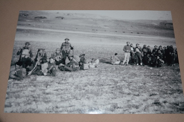
Unit colour patches on uniforms indicate soldiers are members of the 2/24th Battalion.The 2/24th Battalion was an infantry battalion of the Australian Army, which served during World War II .A unit of all-volunteers, it was formed in July 1940 from primarily Victorian volunteers and was known as "Wangaratta's Own" because of the time the battalion spent in the town during its formative period prior to deployment overseas. It served in North Africa in 1941–1942 as part of the 26th Brigade, which was assigned to the 7th Division, before being reassigned to the 9th Division. In early 1943, the battalion returned to Australia and later took part in campaigns against the Japanese in New Guinea in 1943–1944 and Borneo in 1945, before being disbanded in 1946. The 2/24th suffered the highest number of casualties of any 2nd AIF infantry battalion. The Unit was granted the Freedom of the City by the Rural City of Wangaratta in 1996 and one of the first, if not the first, to receive this type of honour. Reproduced black and white photograph of group of armed soldiers at rest in open barren landscape Stamped on rear - resting en route2/24th battalion, wangaratta, middle east -
 Wangaratta RSL Sub Branch
Photograph, c1941
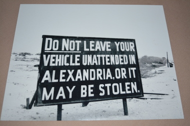
Black and white image of large sign in the desert/barren location. Sign reads DO NOT LEAVE YOUR VEHICLE UNATTENDED IN ALEXANDRIA, OR IT MAY BE STOLEN.The 2/24th Battalion was an infantry battalion of the Australian Army, which served during World War II .A unit of all-volunteers, it was formed in July 1940 from primarily Victorian volunteers and was known as "Wangaratta's Own" because of the time the battalion spent in the town during its formative period prior to deployment overseas. It served in North Africa in 1941–1942 as part of the 26th Brigade, which was assigned to the 7th Division, before being reassigned to the 9th Division. In early 1943, the battalion returned to Australia and later took part in campaigns against the Japanese in New Guinea in 1943–1944 and Borneo in 1945, before being disbanded in 1946. The 2/24th suffered the highest number of casualties of any 2nd AIF infantry battalion. The Unit was granted the Freedom of the City by the Rural City of Wangaratta in 1996 and one of the first, if not the first, to receive this type of honour. Reproduced black and white photograph of large warning sign in English in open barren landscape.2/24th battalion, ww2, middle east, alexandria -
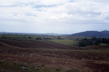 Robin Boyd Foundation
Slide, Robin Boyd, 1966
Robin Boyd was appointed Exhibits Architect for the Australian Pavilion at Expo ‘67 in Montreal. In 1966 Boyd travelled to Far North Queensland and the Northern Territory for research – the Expo exhibits included a coral display and native plant garden.Colour slide in a mount. Landscape, unknown location, probably far north Queensland, AustraliaMade in Australia / 8 / DEC 66M8northern territory, slide -
 Hume City Civic Collection
Photograph
A b/w photograph of a landscape view showing Jackson's Creek with the Sunbury township in the background.Handwritten on back: McMahonmcmahon, landscapes, jackson's creek, sunbury, george evans collection -
 Wangaratta Art Gallery
Painting, John Colin Angus, Ratray's Store and Punt - Crossing the Ovens - 1839, 1963
Rural City of Wangaratta CollectionA landscape of a river crossing painted in oil using shades of green, brown, blue, and white.J. Colin Angus/ (bottom right corner)wangaratta art gallery, j colin angus, john colin angus, landscape painting -
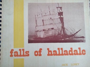 Peterborough History Group
Book, Jack Loney, Falls of Halladale
Falls of Halladale wrecked to the West of Peterborough and the rocky point of land is now named Halladale Point. the book includes information about the history of the ship and photos of her in action, as well as information and photos of the wreck.Jack Loney researched and wrote a number of books about many shipwrecks along the Victorian coast. This limited edition book summarises the history of the barque Falls of Halladale, which wrecked just to the west of Peterborough and includes interesting photos of the ship at sail and as a wreck on the reef.A3 landscape style spiral bound book with stiff, cardboard pages. Limited editionInside it is noted that this is copy number 452 of 1000 copies, and is signed by the author. Also inscribed in pencil is " Donated by Barry Jenkins"shipwrecks, peterborough, falls of halladale, jack loney -
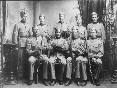 Stawell Historical Society Inc
Photograph - Group Portrait, Victorian Ranger's Stawell c 1890's
2 rows of 9 men in uniform posing for studio portrait. Landscape B/W.Victorian Rangers Stawell 1890'smilitary, boer war -
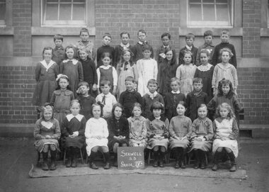 Stawell Historical Society Inc
Photograph, Stawell State School Number 502 Grade 4A
Circa WW 1. Card FoxedB/W Landscape. Group Portrait. 4 Rows of pupis in front of Brick BuildingStawell S.S. Grade VIA Reverse Stawell State School -
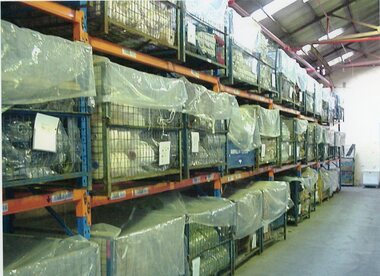 Stawell Historical Society Inc
Photograph - Aunde Album 29, Yarn Store, 2002
Aunde / Norwellan Textiles North Western Woolen Mills became Norwellan Textiles then AUNDEColour landscape photo: Shelving with wire containers of yarn, plastic over open topsAUnde Australia Ltd. logoindustry, aunde -
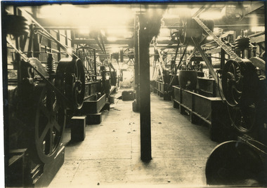 National Wool Museum
Photograph, Scouring Machines, Unknown
Photographs were most likely used for promotional purposes. Room filled with wool scouring machines in an unknown textile mill.Sepia photo of a room filled with Scouring Machines in landscape format, located a textile mill.textile machinery, wool manufacture, wool, scouring -
 Whitehorse Historical Society Inc.
Article, The new offices - City of Nunawading|Open office space for new Civic Centre|Australia's first landscaped office|Office landscaping, 1968
Descriptions from several sources of the new civic centre - Australia's first landscaped office.Descriptions from several sources of the new civic centre - Australia's first landscaped office.Descriptions from several sources of the new civic centre - Australia's first landscaped office.city of nunawading, nunawading civic centre, brown, john henry, black, malcolm charles -
Whitehorse Historical Society Inc.
Document, Whitehorse Planning Scheme, 2002
Amendment C44 to Whitehorse Planning Scheme, to include Walker Estate in the significant landscape overlayAmendment C44 to Whitehorse Planning Scheme, to include Walker Estate in the significant landscape overlayAmendment C44 to Whitehorse Planning Scheme, to include Walker Estate in the significant landscape overlayplanning development, walker estate, mitcham road, mitcham -
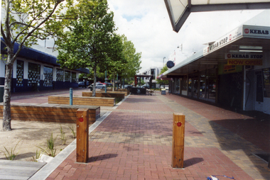 Whitehorse Historical Society Inc.
Photograph, Britannia Mall, Mitcham, 2007
Coloured Photograph of Britannia Mall looking south, after completion of development and landscaping works.britannia mall, mitcham, shops, shopping centres -
 Ballarat Tramway Museum
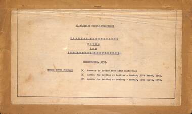
Administrative record, State Electricity Commission of Victoria (SECV), "Notes for 3rd Annual Conference", 1953
Set of notes for the Provincial Tramways Maintenance meeting to be held in Bendigo on 30/5/1953 and in Geelong on 13/4/1953. Has a summary of actions from the 1952 conference (see item 8056) and the Agenda for the respective meetings. See item 8113 for the minutes of these meetings.Yields information and demonstrates SEC Meeting minutes about discussions between the three Provincial operators about tramcars and operations.Twenty Five foolscap typed sheets stapled in a landscape format to a folded manila card.secv, ballarat, trams, tramways, minutes, sec, geelong, bendigo, tramcar equipment, maintenance, trackwork, trolley wheels, motors, maximum traction, employees -
Moorabbin Air Museum
Book (Item) - Australian Civil Aviation Registers, Australian Register of Civil Aircraft
Contains issues 5, 6, 8, 9 and 11. The latter three have the name R. Neate written on the front cover. -
 City of Warrnambool Rowing Club
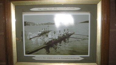
Photograph, The Final for Mrs Rolfe's Trophy
Mrs George Rolfe was the wife of the owner of Lyndoch. He was a Melbourne tea merchant, who owned 216 acres of the Shipley estate further up the Hopkins River. In the late 1870s he bought 2 acres of land and house along the Hopkins near the bridge and developed into Lyndoch. By 1883 he increased to 50 acres. He resoiled the land, put in a water supply reservoir, water tanks and pumps, a reticulation system and a windmill- 50 feet high with four sails 18 feet high and 4 1/2 wide. George Rolfe died in 1919 and the present Lyndoch House was built in 1925. Source: By These We Flourish, A History of Warrnambool by C.E. Sayers and P.L. Yule Edition 1 A4 landscape black and white photograph of a mens rowing four on the Hopkins River, Warrnambool.The Final for Mrs Rolfe's Trophy Presented by Mrs George Rolfe by W.R.C.lyndoch, lyndoch warrnambool, city of warrnambool rowing club, warrnambool rowing club, george rolfe -
 Montsalvat
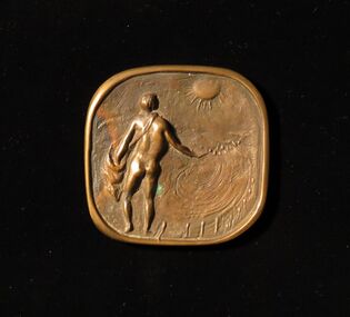
Bronze Plaque, Utitled (Sower)
Square bronze plaque depicting a male nude sowing seeds in a landscape with fence posts. Inscribed on reverse: (Ls) 'Matcham Skipper Montsalvat'matcham skipper, plaque, bronze, male nude, sower -
 Montsalvat
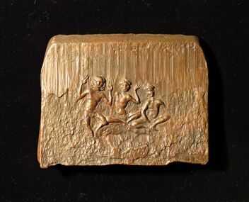
Bronze Plaque, Untitled (Indigenous Dancer)
Bronze plaque depicting a male indigenous dancer with two seated indigenous males in a landscape. Inscribed on reverse (u.r.c) 'Matcham Skipper'matcham skipper, plaque, bronze, indigenous dancer -
 Port Fairy Historical Society Museum and Archives
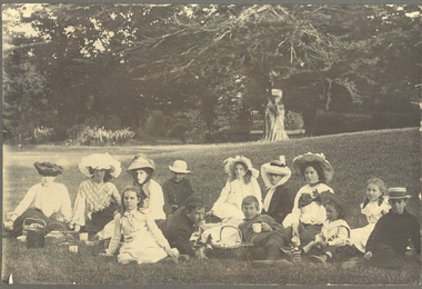
Photograph
Family group picnicing in the Botanical gardens Black and white landscape with 13 people in foreground dressed in clothing of the early 1900’sgardens, family, group, botanical -
University of Melbourne, Burnley Campus Archives
Plan, Anthony Mahady, Rear Courtyard Design 1:50, 1998
Set of drawings for Landscape Design '98, Garden Design Theme: Islamic, by Anthony Mahadylandscape design, anthony mahady, islamic design