Showing 11483 items matching "maps "
-
 Victorian Aboriginal Corporation for Languages
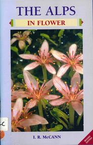
Book, I R McCann, The Alps in flower, 2001
Format using photographs and a brief description of each plant.Maps, colour photographsalps, victorian national parks association, bogong unit, alpine national park, mount buffalo national park, wonnangatta-moroka unit, kosciusko national park -
 Victorian Aboriginal Corporation for Languages
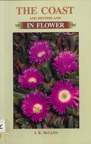
Book, I R McCann, The coast and hinterland in flower, 1992
Format using photographs and a brief description of each plant.Maps, colour photographswildflowers, plants, australia, grampians, identification, native plants -
 Victorian Aboriginal Corporation for Languages
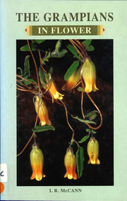
Book, I R McCann, The Grampians in flower, 2000
Contains brief descriptions of flowering plants in the Grampians area.Maps, colour photographswildflowers, plants, australia, grampians, identification -
 Victorian Aboriginal Corporation for Languages
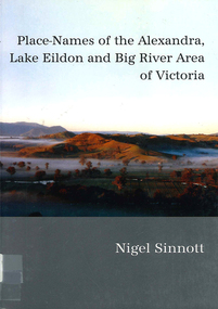
Book, Nigel Sinnott, Place-names of the Alexandra, Lake Eildon and Big River area of Victoria, 2003
Contains 2000 entries for the Alexandra area, giving a clearly detailed description of the site and source of the name.Maps, colour photographsplace names, alexandra, lake eildon, strathbogie ranges, yea, marysville, healesville -
 Victorian Aboriginal Corporation for Languages
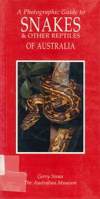
Book, Gerry Swan, A photographic guide to snakes &? other reptiles of Australia, 1997
Species accounts of snakes across Australia.Maps, colour photographssnakes, reptiles -
 Greensborough Historical Society
Map, Melbourne and Metropolitan Board of Works. Survey Division, MMBW, Yarra 2500 / 17.26. Hurstbridge, 1978_01
Melbourne and Metropolitan Board of Works. Yarra 2500 [base map] 17-26. Hurstbridge. Municipalities of Diamond Valley 257 and Eltham 238. Prominent streets include: Flat Rock Road and Heather Avenue. Includes Hurstbridge Railway Station.MMBW Map in 1:2500 [scale] series. Cream parchment with green tape reinforcing on edges and punched holes on left edge.mmbw, melbourne and metropolitan board of works, shire of diamond valley, hurstbridge - maps -
 Greensborough Historical Society
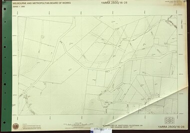
Map, Melbourne and Metropolitan Board of Works. Survey Division, MMBW, Yarra 2500 / 16.28. East of Hurstbridge, 1977_10
Melbourne and Metropolitan Board of Works. Yarra 2500 [base map] 16.28. East of Hurstbridge. Municipalities of Whittlesea 239, Eltham 238 and Diamond Valley 257. Prominent streets include: Boyds Road, Bannons Lane and Wattle Tree Road. MMBW Map in 1:2500 [scale] series. Cream parchment with green tape reinforcing on edges and punched holes on left edge.mmbw, melbourne and metropolitan board of works, shire of diamond valley -
 Greensborough Historical Society
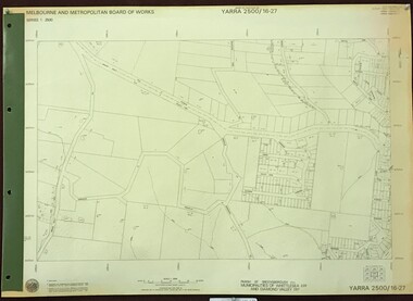
Map, Melbourne and Metropolitan Board of Works. Survey Division, MMBW, Yarra 2500 / 16.27. Hurstbridge, 1977_10
Melbourne and Metropolitan Board of Works. Yarra 2500 [base map] 16.27. Hurstbridge. Parish of Greensborough 2724. Municipalities of Whittlesea 239 and Diamond Valley 257. Prominent streets include: Haleys Gully Road, Kendalls Lane and Bingley Avenue. MMBW Map in 1:2500 [scale] series. Cream parchment with green tape reinforcing on edges and punched holes on left edge.mmbw, melbourne and metropolitan board of works, shire of diamond valley, shire of whittlesea, hurstbridge - maps -
 Greensborough Historical Society
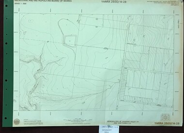
Map, Melbourne and Metropolitan Board of Works. Survey Division, MMBW, Yarra 2500 / 14.28. Yarrambat Park, 1977_09
Melbourne and Metropolitan Board of Works. Yarra 2500 [base map] 14.28. Yarrambat Park. Municipalities of Diamond Valley 257 and Whittlesea 239. Prominent streets include: Bannons Road and Yan Yean Road. Features include the Plenty River.MMBW Map in 1:2500 [scale] series. Cream parchment with green tape reinforcing on edges and punched holes on left edge.mmbw, melbourne and metropolitan board of works, shire of diamond valley, whttlesea, yarrambat - maps -
 Bendigo Military Museum
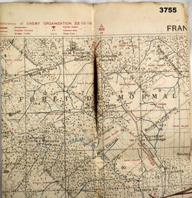
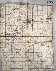
Map - FIELD SURVEY MAP, FRANCE WW1, 1918
Area of map shows the River Sambre running from corner left to top corner right, Landrecies, Hachette, Petit Paris to Leval. Item re William Alexander No 502 AIF. refer cat No 3746.3 for his service details.Map, Enemy rear Organization France, Edition 3a, sheet 57A N.W, scale 1:20,000, Field Survey to 24.10.1918.Hand written on rear in black, “57A N.W”map, france, trench -
 Warrnambool and District Historical Society Inc.
Map, Warrnambool Harbour 1879, 1879
This map shows the plans by eminent harbour engineer, Sir John Coode in 1879. Construction of the breakwater commenced in 1884 and was completed in 1890. Coode first visited Australia in 1872 when he commenced work with the Melbourne Harbour Trust to report on ways to improve Melbourne Port. He is considered one of the most eminent harbour engineers of the 19th century. His original plans for Warrnambool were revised because of cost but then subsequently found to be inadequate and later extended. This was not successful either and the harbour continues to have silting problems to this day. The Warrnambool Breakwater is of historical importance to Victoria and as this map depicts the original plans, it too has great historical significance. It is also significant with its association with Sir John Coode, who was one of the most important port engineers of the 19th century. He worked to improve ports along the Victorian coast including Portland, Geelong, Port Fairy and Lakes Entrance. While this map demonstrates the engineering skills of the era, it also reflects the limitations when natural elements are involved. Its Historical importance also lies in the depiction of items on the map which relate to Warrnambool’s early history. Paper on linen map coloured, and depicting the harbour area of Warrnambool with the proposed breakwater plan in red. It has Victorian Harbours information in oval at top of map. It shows depths of some areas.In oval at top, “Victorian Harbours Warrnambool plan to accompany Sir John Coode report dated 28th Feb 1879. Drawing No 2. Scale 500 feet to 1 inch at bottom centre. Sir John Coode signature in bottom left corner. A 33 A on bottom left reversesir john goode, warrnambool harbour map, warrnambool harbour map 1879, port of warrnambool map 1879 -
 Wangaratta RSL Sub Branch
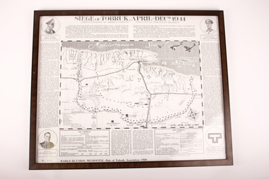
Poster - Framed Poster, Siege of Tobruk, 1980
Poster displays cartography and history of the Siege of Tobruk April to December 1941 Edition Poster ( No. 0768 )was produced for the World Reunion of the Rats of Tobruk Association held in Melbourne 1980Commemorates the Battle of TobrukBlack plastic frame containing poster of Map in centre with circles in each corner with images of soldiers and a symbol in lower right corner.Biographies of: Major General Leslie J Morshead - Tobruk Fortress Commander and Lieut General Erwin Rommel - Commander, German Afrika Korps. Map of Battle Zone. Lithographic of Corporal J.H.Edmonson VC - 2/17 Battalion.tobruk, 1941 -
 Surrey Hills Historical Society Collection
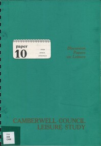
Book, Camberwell Council - Open Space Strategy: paper 10, 1982
Series title: Camberwell Council Leisure study: discussion papers on leisure; 10 126p.; maps; This discussion paper only present draft policies, and are published in this form to obtain the opinions of the community, councillors, field-workers and experts.126p.; maps; This discussion paper only present draft policies, and are published in this form to obtain the opinions of the community, councillors, field-workers and experts.open spaces, camberwell, victoria, recreational use -
 Bendigo Military Museum
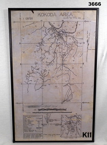
Map - MAP, KOKODA MOUNTED, 2nd Aust Field Survey Section, 4.9.1942
Map was compiled from aerial photos without ground control or inspection & with information received from Major CAMERON.Laminated map of Kokoda area on board backing with black border. Black printing on cream / fawn background. White hanging strap on back. Information ledger bottom LHS. Kokoda inset bottom RHS.Printed at top: “KOKODA AREA” Printed at bottom “RHS: K11”map, kokoda, mounted -
 Greensborough Historical Society
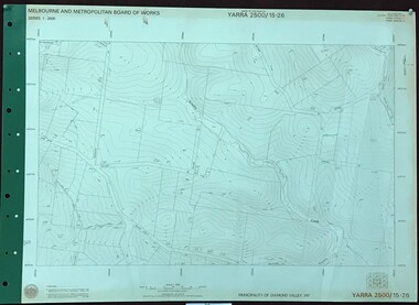
Map, Melbourne and Metropolitan Board of Works. Survey Division, MMBW, Yarra 2500 / 15.26. Yarrambat, Hacketts Road, 1978_07
Melbourne and Metropolitan Board of Works. Yarra 2500 [base map] 15.26. Yarrambat, Hacketts Road. Municipality of Diamond Valley 257. Prominent streets include: Black Gully Road, Hacketts Road and Collins Lane. Features include Scrubby Creek.MMBW Map in 1:2500 [scale] series. Cream parchment with green tape reinforcing on edges and punched holes on left edge.mmbw, melbourne and metropolitan board of works, shire of diamond valley, yarrambat - maps -
 B-24 Liberator Memorial Restoration Australia Inc
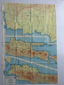
Map - British World War II silk map of Sumatra (South) and Java (Extreme North West), 1944
Silk and rayon maps were produced by Great Britain (some 1.75 million in total), the United States (c.7.5 million) and Australia during World War II. They were issued to Allied military personnel as part of 'escape and evasion' kits.This map, printed on rayon, is an original British 'escape and evasion' kit map from World War II.A multi-coloured, contoured, double-sided map printed on rayon, 1944 Series South West Pacific Area (SWPA) and Asia Sheet G Sumatra (South) and Java (Extreme North West) and, on the reverse, Sheet H Borneo (South West), Java and Sumatra (Extreme South)world war ii, silk maps, great britain, a187 -
 Linton and District Historical Society Inc
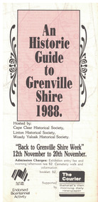
Document - Leaflet, An Historic Guide to Grenville Shire, 1988
... Maps ...A4 sized printed leaflet folded into three. White background with pink rectangle on front. Black printed text throughout. Inside of leaflet is a map with places of interest circled and numbered in red ink.Text, front: 'An / Historic / Guide / to / Grenville / Shire / 1988. / Hosted by: / Cape Clear Historical Society, / Linton Historical Society, / Woady Yaloak Historical Society. 'grenville shire, cape clear historical society, linton historical society, woady yaloak historical society, bicentennial celebrations, maps -
 Bendigo Military Museum
Map, 1917
Area of map covers the Somme from Suzanne, Clery, Perone then onto Doingt, Rosiel, Ronssoy. Item re William Alexander No 502 AIF. Refer Cat No 3746.3 for his service details. Map, France, Ordnance survey May 1917, Edition 1, sheet 62c, scale possibly 1:20,000. On rear is a glossary of terms French to English.map, trench, france -
 Ringwood and District Historical Society
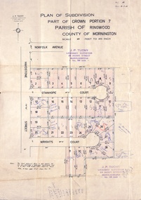
Document, Plan of Subdivision - Part of Crown Portion 7, Parish of Ringwood, County of Mornington - 1962
Map of residential allotments coloured red, with land coloured blue set apart for drainage & sewerage easements. Rubber stamped J.P. Tuohy, Licensed Surveyor, 25 Howe Street Murrumbeena, Tel. 561945, dated 38.8.1962.Map includes Maidstone Street, Norfolk Avenue, Stanhope Court and Wrights Court, Ringwood, Vic. Also includes handwritten Estate Agent sales notations. -
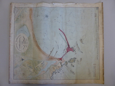
 Flagstaff Hill Maritime Museum and Village
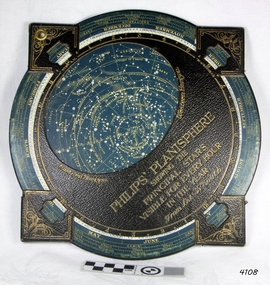
Planisphere, Early 20th Century
... maps ...The word Planisphere (Latin planisphaerium) was originally used in the second century by Claudius Ptolemy to describe the representation of a spherical Earth by a map drawn in the plane. This usage continued into the Renaissance: for example Gerardus Mercator described his 1569 world map as a Planisphere. The word describes the representation of the star-filled celestial sphere on the plane. The first star chart to have the name "Planisphere" was made in 1624 by Jacob Bartsch. Bartsch was the son-in-law of Johannes Kepler, discoverer of Kepler's laws of planetary motionA significant item of celestial mapping used by marine navigators This particular item was made and used in the first quarter to half of the 20th century.Planisphere consists of a circular star chart attached at its centre to an opaque circular overlay that has a clear elliptical window or hole so that only a portion of the sky map will be visible in the window or hole area at any given time. The chart and overlay are mounted so that they are free to rotate about a common pivot point at their centers. The star chart contains the brightest stars, constellations and (possibly) deep-sky objects visible from a particular latitude on Earth. The night sky that one sees from the Earth depends on whether the observer is in the northern or southern hemispheres and the latitude. A Planisphere window is designed for a particular latitude and will be accurate enough for a certain band either side of that. Planisphere makers will usually offer them in a number of versions for different latitudes. Planispheres only show the stars visible from the observer's latitude; stars below the horizon are not included. A complete twenty-four-hour time cycle is marked on the rim of the overlay. A full twelve months of calendar dates are marked on the rim of the star chart. The window is marked to show the direction of the eastern and western horizons. The disc and overlay are adjusted so that the observer's local time of day on the overlay corresponds to that day's date on the star chart disc. The portion of the star chart visible in the window then represents (with a distortion because it is a flat surface representing a spherical volume) the distribution of stars in the sky at that moment for the Planispheres designed location. Users hold the Planisphere above their head with the eastern and western horizons correctly aligned to match the chart to actual star positions. "Sold by J DONNE & SON, Booksellers & Stationers, 349 Post Office Place Melbourne 349. Admiralty Chart Agents" and " Made in Germany for George Philip & Son Ltd" England . Signature "Capt E. B. ?..id, 22 Baund St"flagstaff hill, warrnambool, shipwrecked-coast, flagstaff-hill, flagstaff-hill-maritime-museum, maritime-museum, shipwreck-coast, flagstaff-hill-maritime-village, star map, marine navigation, maps, george philip & sons -
 Whitehorse Historical Society Inc.
Map, Environment effects statement, 1/03/1979 12:00:00 AM
Diamond Creek-Ringwood study: Planning Scheme reservations and zones with recommended concept.Diamond Creek-Ringwood study: Planning Scheme reservations and zones with recommended concept. City of Nunawading: section north of Canterbury Road. Scale 1:25,000 metric. Map B with drafting ref. no. 145Diamond Creek-Ringwood study: Planning Scheme reservations and zones with recommended concept. city of nunawading, land use, melbourne metropolitan planning scheme -
Whitehorse Historical Society Inc.
Map, Dandenong Ranges area. Sheet 7, c1957
... maps ...Detailed map covering area from Mitcham and Vermont to Ringwood and Heathmont.Detailed map covering area from Mitcham and Vermont to Ringwood and Heathmont. Shows streets, block boundaries, buildings, railway and creeks. Note says prepared from State Aerial Survey, April 1954 and Cadastrial Survey information July 1956.Detailed map covering area from Mitcham and Vermont to Ringwood and Heathmont. maps, mitcham, vermont, ringwood, heathmont -
 Kew Historical Society Inc
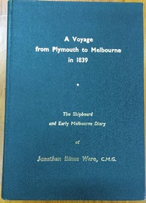
Book, J B Were & Son, A voyage from Plymouth to Melbourne in 1839: The shipboard and early diary of Jonathan Binns Were, 1964
[Melbourne] : J.B. Were & Son, 1964 xv, 309 p. : ill., facsims., maps, port. ; 20 cm. non-fictionwere, jonathan binns, victoria - history -
 Kew Historical Society Inc
Book, Oxford University Press, The Narrative of George Russell of Golf Hill with Russelliana and selected papers, 1963
Account of early pastoral settlement in Tasmania and Port Phillip focusing on the progress of the Russell family; includes observations on relations between settlers and Aborigines; account of the Black War in Tasmania; story of William Buckley, description of Port Phillip Aboriginal shelters, corroborees, missions, rapid extinction.London : Oxford University Press, 1935 469 p. : ill. map, ports., geneal. table ; 25 cm. non-fictionAccount of early pastoral settlement in Tasmania and Port Phillip focusing on the progress of the Russell family; includes observations on relations between settlers and Aborigines; account of the Black War in Tasmania; story of William Buckley, description of Port Phillip Aboriginal shelters, corroborees, missions, rapid extinction.russell family, clyde company, voyages and travels -
 Kew Historical Society Inc
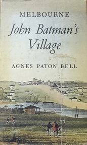
Book, Agnes P Bell, Melbourne: John Batman’s Village, 1965
A history of Melbourne, tracing its development from the riverside village founded by John Batman to the metropolis of the 1960s; includes description of Aboriginal corroborees and other early encounters with the Aboriginal inhabitants of the area.Melbourne, Vic. : Cassell Australia, 1965 xiv, 178p. : ill. (some col.), facsims., map, porto. ; 25cm. non-fictionA history of Melbourne, tracing its development from the riverside village founded by John Batman to the metropolis of the 1960s; includes description of Aboriginal corroborees and other early encounters with the Aboriginal inhabitants of the area.batman, john, 1801-1839, melbourne (vic.) -- history., settlement and contacts - colonisation - 1851- -
Tatura Irrigation & Wartime Camps Museum
Book, The River Murray, 1990
Written to record history of River Murray from aboriginal times, early settlers, riverboats, maps, irrigation, agriculture.Map of Murray River and districts on front cover. 4 river scenes in square boxes. Gold disc, paddle steamer, names of 3 states. Early scenes n back cover. 1 present day.irrigation, books, reference, rural, industry -
 Bendigo Military Museum
Administrative record - Royal Australian Survey Corps - Central Command Operation Order C/1/61 Northern Territory 1961, DAD Svy, HQ Central Command , Keswick Barracks, SA, 1961
This is a Central Command Operation for the Royal Australian Survey Corps to conduct a Survey Operation in Northern Territory in 1961. The task is to acquire Survey Control for the production of maps coving the following 1:250 000 map areas of Alligator River, Mt Evelyn, Coburg Peninsula, (including the offshore Islands, Melville Island and Bathurst Island. The Operation Order details the tasks for the 6 x Officers (or equivalent) and 34 x OR's (or equivalent) and the support that was allocated including Frigate HMAS Gasgoyne, LSM landing craft, Trucks amphibian (DUKW), Helicopter and Cessna aircraft.A 11 x page foolscap size paper report and 1 x foldout map Annex held together with a paper clip. Two hole punched.Hand written File Number in top RH Corner "101-310-4". Distribution stamp in top LH Corner. Hand written No7 in Top RH Corner.royal australian survey corps, rasvy, fortuna, army survey regiment, army svy regt -
 Bendigo Military Museum
Map - TRENCH MAP, FRANCE WW1, 1918
Areas covered on this map, “Ribemont, Morlancourt, Dernacourt, Fricourt, Mericourt, Saily Le Sec” Item re William Alexander No 502 AIF. Refer Cat No 3746.3 for his service details.Trench map, France, Edition 2 E, sheet 62D N.E, scale 1:20,000, trenches corrected to 28.5.1918, German trenches in red, British in blue.map, france, trench -
Whitehorse Historical Society Inc.
Document, Kelly Gang Film, 1994
Manuscript notes with typed copy. The 'Kelly Gang' film at 1320ft long which ran for over an hour is longer than the film 'The Great Train Robbery' (1903) claimed as the first full length picture made in the world.Manuscript notes with typed copy. The 'Kelly Gang' film at 1320ft long which ran for over an hour is longer than the film 'The Great Train Robbery' (1903) claimed as the first full length picture made in the world. 'Lowberry' timber house owned by McDonnells (with sketch map)Manuscript notes with typed copy. The 'Kelly Gang' film at 1320ft long which ran for over an hour is longer than the film 'The Great Train Robbery' (1903) claimed as the first full length picture made in the world. mcdonnell family, the story of the kelly gang (film), films -
 Bendigo Military Museum
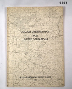
Administrative record - Royal Australian Survey Corps - Colour Orthophotos for Limited Operations 1971, Army Survey Regiment, Bendigo, 1971
This is a report on the experimental production of the colour Orthophoto Map 1:25,000 7924 - 3 - SW Northwood (Puckapunyal area) during 1971 conducted at the Army Survey Regiment Bendigo. The report covers all aspects of production including cartographic enhancement, test proofing, platemaking and printing. While Annexes A and C are listed in the contents, they are missing from the document. A second copy has been added to this record that contains Annex A that is a colour enhanced colour orthohotomap of the map sheet.Soft covered A4 sized booklet stapled along the left hand side. Title and a greyed map image printed on cover. A second copy containing Annex A was added in 2025royal australian survey corps, rasvy, fortuna, army survey regiment, army svy regt, asr