Showing 37453 items matching "orbost-shire-council"
-
 Orbost & District Historical Society
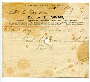
account, 13th May, 1915
E. Swan (of Bairnsdale) purchased the Orbost Tank Factory from Mr E. F. Reynolds. Swan was a tinsmith, coppersmith, plumber, zinc and iron worker who specialised in repairing tanks. Robert Pullar Cameron was a Shire Councillor for many years. He married Penuel Hossack and had a family of James, Flora, Penuel and Alex.This item is an example of the book-keeping of an Orbost business in the early 20th century and is a useful research tool.A very stained shite paper account with black print and red lines from E. Swan, Orbost Tank Factory, to R. Cameron.swan-e. cameron-robert-pullar -
 Whitehorse Historical Society Inc.
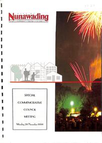
Document, Special Commemorative Council Meeting, Monday, 28th November, 1994, 1994
Notice and Agenda of meeting for a special commemorative meeting of Nunawading City Council. Includes biographical details of all Councillors at the Shire of Blackburn and Mitcham and the City of Nunawading 1925-1994. 16 pages.non-fictioncity of nunawading, shire of blackburn and mitcham, councillors -
 Learmonth and District Historical Society Inc.
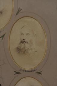
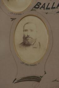
Photo-Edwards, Richards & Co.Photos Ballaarat, Councilor Francis Edwards 1883-84, "circa 1884"
Councilor Francis Edwards was elected as a member of council in1872 until 1886.He only served one term as President in1878-79.His residence was Coghills Creek and later Ascot.This original photo forms part of a collection showing all councilors for the year 1883-84.This photo of Councilor Francis Edwards,is in sepia and oval in shape set in a "light tan" mount with gold trim around "cutout".Around photo a fine line is drawn with decorative features connecting it to the next photo. Councilor J.Edwards name is inscribed at the base of the photo.It is set on the right side, second from top of circle of photos showing all councilors for 1883-84. PRESENTED by the PRESIDENT J. DALGLIESH ESQ.to the BALLAARAT SHIRE COUNCIL 1883-84.ascot, ballarat shire council, francis edwards 1883 84, coghils creek -
 Learmonth and District Historical Society Inc.
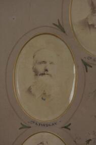
Photo - Findlay, Richards & Co. Photos Ballaarat, Councilor Alexander Findlay 1883-84
Councilor Alexander Findlay was elected to council in 1873 and again in 1879-85.He did not serve as President during that time.He resided at Ercildourne.This original photo forms part of a collection of photos showing all councilors for the year 1883-84.This oval sepia photo is of Councilor Alexander Findlay,set in a "light tan" mount with gold around edge of "cutout". A fine black line surounds the photo linking it to the next.It forms part of a collection of photos of all councilors for the year 1883-84 and is second from the top,left hand side. PRESENTED by the PRESIDENT J.DALGLEISH ESQ.To the BALLAARAT SHIRE COUNCIL 1883-84.ballaarat shire council 1883 84, alexander findlay, ercildourne -
 Orbost & District Historical Society
rate books, 1977 - 1984
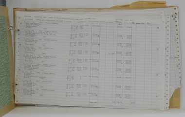
These items were donated to Orbost & District Historical society from P.R.O.V. as a Place of Deposit (POD) item for safe keeping by a local history group or museum. The shire covered an area of 9,347 square kilometres and existed from 1892 until 1994 when it became part of the East Gippsland Shire Council. The East Gippsland Region Water Authority was constituted on January 1, 1995. The new Authority assumed responsibility for the services previously provided by the Mitchell Water Board, the Tambo Water Board, the Orbost Water Board and the Mallacoota Water Board. East Gippsland Water is the registered business name of the East Gippsland Region Water Authority. (info. from P.R.O.) These items are a historical record of Orbost Shire transactions with water management authorities which no longer exist.Seven rate books for the Shire of Orbost, Mallacoota and Cann River Water Trust. 2554.1 with records from 1977-1978 has a brown cardboard cover and string binding. 2554.2 has a brown cardboard cover with a hand-written title and green string binding. Records are from 1978 -1979. 2554.3 has a brown cardboard cover with a hand-written title and green string binding. Records are from 1919 - 1980. 2554.4 has a white cardboard cover and taped spine. In black print on the cover is 1980/1981. 2554.5 has a green cover with a metal fastening clip. Records are from 1980 -1981. 2554.6 has a white cover, taped binding and metal clips.Records are from 1982 -1983. 2554.7 has a white cover and metal rings. It is dated 1984.water-rates cann-valley-water-board -
 Orbost & District Historical Society
railways envelope, Victorian Railways, c. 1970s-1980s
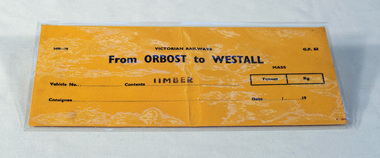
Used at Orbost railway station for the consignment of goods/freight, in this case, timber to Westall. The Bairnsdale-Orbost railway was opened in 1916 to serve the agricultural and timber industry. Because of the decline in traffic and heavy operating costs, the line was finally closed in August, 1987. Orbost Railway Station was opened on Monday 10 April 1916 as the terminus of the Orbost railway line, and closed in 1987. The station was located on the west side of the Snowy River despite the town of Orbost being on the east side of the river, in order to save on the costs of a bridge over the river, which at the time had highly variable levels. This item is associated with the history of the Orbost-Bairnsdale railway line and therefore reflects the role that the rail line played in the social and economic history of Orbost.An unused brown/buff coloured goods/freight consignment envelope used by Victorian Railways, this one for timber from Orbost to Westall. 2498-78 VICTORIAN RAILWAYS From ORBOST to WESTALL Contents TIMBER railway-history orbost-bairnsdale-railway -
 Orbost & District Historical Society
black and white photograph, late 19th century - early 20th century
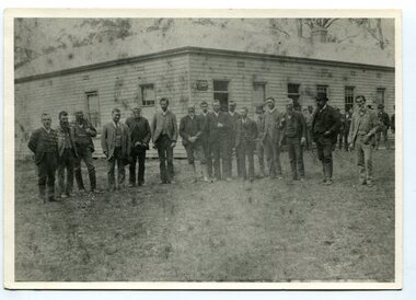
Probably taken 1890's before Orbost was separated from Tambo. The Shire of Tambo was a local government area about 320 kilometres east of Melbourne. The shire covered an area of 3,506.86 square kilometres and existed from 1882 until 1994. Tambo was first incorporated as a shire on 6 January 1882, splitting away from the Shire of Bairnsdale. On 30 May 1892 it lost three-quarters of its land area when the Shire of Orbost was incorporated. A small amount was re-annexed as Cunninghame Riding on 3 January 1913. On 2 December 1994, the Shire was abolished, and merged with the City and Shire of Bairnsdale, Shire of Orbost, most of the Shire of Omeo and the Boole Boole Peninsula from Shire of Rosedale into the Shire of East Gippsland. ( more information Newsletter July 2010). This photograph is of Tambo Shire Council meeting at Faithful's Hotel, Nowa Nowa. It includes Snowy River Riding councillors. Mary Stirling, wife of Shire Secretary Thomas Telfer Stirling, took over the Nowa Nowa Hotel from Moses Faithful in 1895. Photograph includes: John Butter BESLEY, John William BORLAND, Charles Begg IRVINE, William J. LAMBOURN, James LARKIN, Ronald McDOUGALL, Donald McRAE, William ROADKNIGHT jnr., David WILLIAMS, James CAMERON, Charles Henry GROVE. (info. John Phillips) This item is associated with the Tambo Shire Council, a local government which no longer exists.A black / white photograph of a group of men standing in a line outside a large timber building.on back - "Tambo Shire Council . Meeting at Nowa Nowa - Stirling's Hotel"tambo-shire-council faithful's-hotel-nowa-nowa local-government -
 Stawell Historical Society Inc
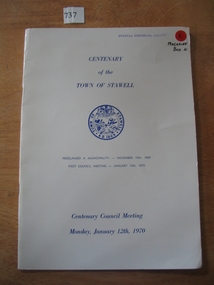
Book, Town of Stawell, Centenary of Town of Stawell - Centenary Council Meeting 1970, 1969-1970
Produced for the Centenary of the town of Stawell. contains Photographic copy of the proclamation of the Borough of Stawell, list of the members of the Borough Council 1870, Minutes of the first meeting of the Council. Past Mayors and othe rinformation White Card Cover with Blue Print, including the Town of Stawell seal,Centenary of the Town of Stawell (Seal of Stawell) Proclaimed a Municipality - November 10th 1869 First Council Meeting January 12th 1870 Centenary Council Meeting Monday, January 12th, 1970stawell -
 Rutherglen Historical Society
Image, Alf L. Bowden, The Studio, Union of Rutherglen Shire and Borough, 1920 (Exact)
Copy of a photograph of Wesleyan Church used as temporary Shire Office during building of new office. Group portrait of Councillors in front of building."Union of Rutherglen Shire and Borough / Date of Union: December 15, 1920. Dissolution of Combined Councils: August 25, 1921. Rutherglen Shire Office. The Secretary Attends Monday & Friday 10am till 4pm" Front row (left to right) Ex. Cr. S.P. Gollings, Cr. R. Ready, Cr. E.E. Cock, Cr. J. Burch (Ex Mayor), Cr. C.H. Morris (Shire President), J. Hiskins (Ex President), Cr. R.J. Burrowes, Cr. D.B. Smith, Cr. P. Gullifer / Centre Row (left to right) Cr. H.G. Richards, Cr. W.H. Chambers, Cr. R.H. Berryman, Cr. R.J. Harvie, Cr. W.R. McRae, Cr. W.V. McDonald, Cr. C.L. Dobbin, Cr. R.A. McLaurin, Cr. P.M. Seymour, Cr. M.T. Graham, Cr. F. Fuge, Cr J. Milthorpe / Back Row (left to right) T. Trenen (Editor "Sun"), P. Lingford (Shire Engineer), W.C. Bayliss (Banker), A.H. Thompson (Shire Secretary, A.C. Carter (Inspector), N.F. Turnbull (Assistant Secretary)" -
 Ringwood and District Historical Society
Archive - Parent Record, Maroondah City Council, Ringwood City Council - Archive Collection
Parent Record for Archive collection of photographs and documents relating to Ringwood City Council, and the later Marronah City Council -
 University of Melbourne, Burnley Campus Archives
Certificate, Melbourne City Council 1939, 1939
Certificate issued by Melbourne City Council inscribed, 'This is to Certify that School of Horticulture Burnley Exhibited Flowering Shrubs, Roses, Iris, Dianthus, etc. at "Garden City," Treasury Gardens, Melbourne during the period 23rd October to 18th November, 1939, Town Hall, Melbourne. Signed by A.W. Coles, Lord Mayor of Melbourne.'Certificate issued by Melbourne City Council inscribed, 'This is to Certify that School of Horticulture Burnley Exhibited Flowering Shrubs, Roses, Iris, Dianthus, etc. at "Garden City," Treasury Gardens, Melbourne during the period 23rd October to 18th November, 1939, Town Hall, Melbourne. Signed by A.W. Coles, Lord Mayor of Melbourne.'melbourne city council, flowers, plants, exhibition, treasury gardens, a.w.coles, 1939, garden city, town hall, lord mayor, certificate -
 Kew Historical Society Inc
Photograph - Photograph [copy], Council Family Hotel, Cotham Road, circa 1888, c.1888
The Council Family Hotel was the fifth of the eight hotels to be licensed in Kew during the 19th Century. They were licensed in the following date order: The Woodman Inn (1854), The Harp of Erin (1854), O’Shaughnessy’s Kew Hotel (1855), the Prospect Hill Hotel (1858), the Council Family Hotel (1861), the Princess Hotel (1864), the Clifton Hotel (1868) and the Greyhound Hotel (1873).Rare photograph of a landmark Kew HotelExterior - Council Family Hotel, Cotham Road, Kew, circa 1888.Mr Pat Ryan in doorwayhotels - kew, council family hotel - kew (vic) -
 Kew Historical Society Inc
Photograph - Photograph [copy], Council Family Hotel, Cotham Road, circa 1888, c.1888
The Council Family Hotel was the fifth of the eight hotels to be licensed in Kew during the 19th Century. They were licensed in the following date order: The Woodman Inn (1854), The Harp of Erin (1854), O’Shaughnessy’s Kew Hotel (1855), the Prospect Hill Hotel (1858), the Council Family Hotel (1861), the Princess Hotel (1864), the Clifton Hotel (1868) and the Greyhound Hotel (1873).Rare photograph of a landmark hotel in KewExterior - Council Family Hotel, Cotham Road, Kew, circa 1888.hotels - kew, council family hotel - kew (vic) -
 Orbost & District Historical Society
documents in folder
These documents were used by the Orbost Rifle Club.The Orbost Rifle Club existed in the early 20th century. (There are records from 1900). It folded in the late 1970's. It had a substantial membership.A light brown folder containing early correspondence of the Orbost Rifle Club. It has red print on the front cover.correspondence documents orbsot-rifle-club -
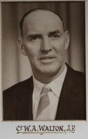 Learmonth and District Historical Society Inc.
Photo - Walton, Possibly Drumond Studios, Walton, W.A.(J.P.),Councilor 1959, 1959
Councilor W.A.Walton (J.P.),was elected Ballarat Shire council in 1955,serving till 1979. He was Shire Preident in 1962-63,1966-67,1978-79. This was part of a collection of photos taken to Commemorate the Opening of the Wendouree Municiple Centre on 20th November 1959. Original Historical photo of councilors for 1959. Councilor W.A.Walton,(J.P.).Sepia photo on white mount,situated second from left, top row of composite photo of all councilors for the year 1959.Collection of photos of Councilors for 1959. walton w a j p, ballarat shire council 1959, wendouree municiple centre opening 20th november 1959 -
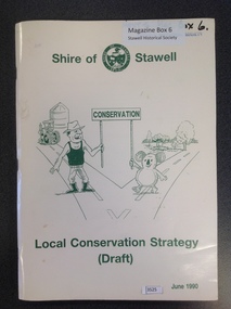 Stawell Historical Society Inc
Book, Shire of Stawell, Local Conservation Strategy (Draft), 1990
Shire of Stawell Conservation Strategy (DraftCream card cover with green print and drawing of a man, koala, silo, tactor and two roads and trees.Shire of - Shire of Stawell coat of arms - Stawell Conservation Local Conservation Strategy (Draft) June 1990stawell -
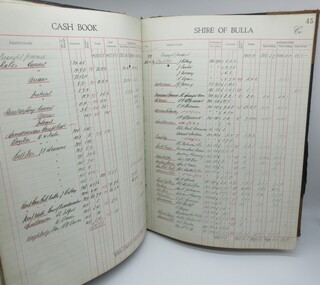 Hume City Civic Collection
Cash Book, Shire of Bulla Cash Book
The Cash Book has been hand written and used by the Shire of Bulla to record the Debits and Credits between April 1937 and March 1943. Numerous fees, charges and costs associated with running the Shire of Bulla are mentioned.Large cloth covered hard cover book with tan corners and spine. Gold lettering on front cover. Blue and red mottled pattern inside front and back covers."Dr. Cash Book/Shire of Bulla Cr..."1930s, 1940s, shire of bulla, sunbury, george evans collection -
 Orbost & District Historical Society
photographs, Snowy River Mail, C1968
These photographs were probably published in the Snowy River Mail. Some of the Orbost identities in the photographs are: Jim Holden; Brian Morgan; Clarrie Ingram; Jeffrey Fecondo; David Holden; Brian Holden; Richard Morgan; Sue Joiner and Charlie Owen. They were taken in the Poultry Shed at the Orbost Show at the Newmerella Showground. The first meeting to form an Agricultural society in Orbost was convened by the then Orbost Progress Association and held in the Mechanics Hall on Saturday, 10th October 1891. Its first show was held on 3rd March 1904...on a site alongside the Bonang Road where the present Golf Club stands. It is currently held at the Recreation Reserve at Newmerella. (Ref: In Times Gone By-Deborah Hall)These photographs are associated with the Orbost Agricultural Society 's Annual Show which has been a major event in Orbost for over a century. Agricultural shows are an important part of cultural life in small country towns and the Orbost Show is an integral part of Orbost 's agricultural history.Twenty-two black / white photographs and four coloured photographs. all are related to the Orbost Agricultural Show.poultry agriculture-show-orbost -
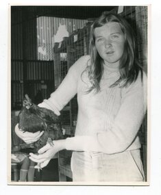
 Orbost & District Historical Society
black and white photographs, Snowy River Mail, 1990
Wendy Blackburn was in charge of T.A..F.E. Orbost and the photographs were taken in her office. Also in the photographs are Tracey Barnett, Peter Cook and Dan Osborne. The Orbost Education Centre is a community based not-for-profit local organisation. It has been in operation since 1976. The programs respond to the needs of the community and short courses are delivered throughout the year for people of all ages and backgrounds. The basis is promoting learning, connectedness and belonging. It is supported by funding from the community, state government and non-government organisations. TAFE offered adult education to those new out of school and mothers coming out of motherhood as well as others. These photographs are pictorial records associated with adult education in Orbost.Five black / white photographs related to adult learning in Orbost. education-adult-orbost t.a.f.e.-orbost -
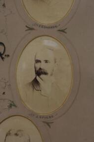 Learmonth and District Historical Society Inc.
Photo - Spiers, Richards & Co. Photos, Ballaarat, Councilor John Pollock Spiers. 1883-84, "circa 1884"
Councilor John Pollock Spiers was elected to council in 1878 until 1880,1880 until 1892,1893 until 1902,1904 until 1910 and 1915 until 1918.He served two terms as President,1889-90 and 1899-1900.Councilor Spiers was a resident of Learmonth.Part of original collection of photos showing all councilors for 1883-84. This photo of Councilor John Pollock Spiers is in sepia tones and oval in shape,set in a "light tan"mount with gold edging around the cut out.Surounding the photo is a fine line and decorative features which link it to the next photo. It is on the right side second from bottom of the circle of photos showing all councilors for 1883-84. PRESENTED by the PRESIDENT J.DALGLIESH ESQ. to the BALLAARAT SHIRE COUNCIL 1883-84.ballarat shire council, john pollock spiers 1883 84 -
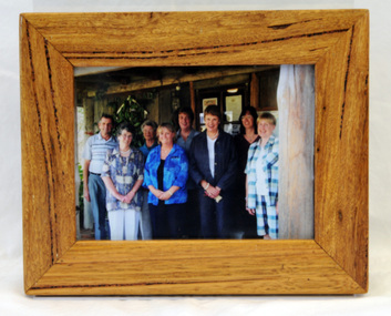 Orbost & District Historical Society
framed photograph, 14.4.2004
This photograph was taken on 14.4.2004 at the time of the visit to Orbost by the Governor of Victoria, John Landy.The Orbost Visitor Information Centre is situated in Forest Park on Nicholson Street. The centre is housed in the historic Slab Hut. The hut was an original family dwelling built in 1872, on a site approximately three kilometres upstream from the junction of the Buchan and Snowy Rivers. The Slab Hut is an Orbost Icon. It supports one part time manager and a team of dedicated volunteers.A coloured photograph in a wooden frame. A group of people stand in front of the Slab Hut (Orbost Information Centre) .On frame - NATURAL FEATURED HARDWOOD MADE BY 20.12.98 W. ASHLYN MARLO VIC.slab-hut-committee photograph -
 Eltham District Historical Society Inc
Photograph, Tess Justine (Nillumbik Shire Council), Murray's Bridge over the Diamond Creek, Eltham North, 19 Feb 2022
Murray's Bridge over the Diamond Creek on the Diamond Creek Trail just prior to demolition and replacement with a new steel bridge. Heritage advice obtained by Nillumbik Shire Council, following a suggestion by the Eltham District Historical Society (EDHS), is that the original bridge appears to have been a simplified version of the Country Roads Board’s (CRB) standard timber bridge design of the early-to-mid 1920s. In c1990 Murray’s bridge was renovated with three recycled steel girders as part of a bike/pedestrian path in the reserve. During these alterations many parts of the bridge were removed, and some were replaced. Heritage advice indicates the condition of Murray’s bridge is poor. The remaining original parts are all in poor condition, with severe weathering, splitting and rot, especially to the stringers retained on the bridge. Heritage advice is that Murray’s Bridge does not have sufficient significance in the cultural history of the Nillumbik area to warrant inclusion in the Nillumbik Shire Heritage Overlay and also does not have sufficient significance as a rare survivor to warrant inclusion in the Nillumbik Shire Heritage Overlay. There are no indications in the historical record that this site was individually important to the cultural history of this area. EDHS is comfortable with the heritage advice provided to Council and has worked closely on this project with Council. EDHS has suggested some of the removed timbers be used in the vicinity of the bridge for landscaping and possibly seating, so as to retain these remnants close to the site of the original bridge, which is the last old timber bridge along the lower reaches of the Diamond Creek. Mary (Sweeney) Murray and John Wright Murray selected 80 acres, Lot C Section 16 and Lot 5 Section 17 Parish of Nillumbik, under an occupation license in 1866. John died in 1867 and freehold was granted to his son John in 1873. The farm was known as ‘Laurel Hill’. John Junior was an Eltham Shire councillor and sometime president from 1887 up until 1897. He added Lot A Section 16 to the farm in ca1888. John and his younger brother James arranged to rent/purchase Lot B Section 17, across Diamond Creek to the west, in ca1900. It appears that John and James farmed separately for a few years, with a new homestead built for James ad family on the high point of Lot B Section 17 in ca1910. John sold off Lot 5 Section 17 in 1912. When John died in 1912 James took over the land on both sides of the Diamond Creek. The old homestead on the west side of the Creek disappeared. A farm bridge over Diamond Creek from this period may have been located close to the northern boundary of the farm. John Langlands, owner of the farm known as ‘Ihurst’ on the west side of Diamond Creek to the south of the Murray’s land, died in 1907. In 1909 his land was then subdivided into 100 lots to become the ‘Glen Park Estate’. Other similar subdivisions of nineteenth century farms around Eltham in this period included the ‘Franktonia (or Beard’s) Estate’ to the northeast and ‘Bonsack’s Estate’ between Eltham and Greensborough. Soon after the opening of the railway extension line from Eltham to Hurstbridge in 1912, Glen Park and nearby residents including James Murray agitated for a railway station or siding to be located half-way between Eltham and Hurstbridge, so that the Glen Park residents who used the railway daily did not have to walk into the Eltham or Hurstbridge stations. Some believed Coleman’s Corner (opposite Edendale Farm) was an appropriate spot for the platform. James Murray was among those who thought the railway should be located on his land, closer to half-way between Eltham and Hurstbridge stations. The Railways Commissioners warned that the locals would have to fund these works themselves. The Glen Park Estate residents initially had difficulty accessing Eltham by road, with only an old low-level bridge over Diamond Creek at the south end of their estate. A new timber trestle bridge across the creek, now on Wattletree Road, was opened in 1915. Road access to the north was gained in 1927 when the new Murray’s Road, which crossed the Murray’s land, was built. Residents continued to agitate for a Glen Park station. By 1926 the Railways Commissioners’ preferred site was on the Murray’s land. They arranged an estimate of cost of a full-length platform. The estimate was too much for the locals, who in 1928 argued unsuccessfully for a shorter and hence cheaper platform. By 1929 Murray had agreed to donate the land, but the locals would still have to fund the works. Murray decided, unilaterally it would appear, to commence work on a timber trestle road bridge over Diamond Creek to link the new Murray Road to the proposed station. Late in 1929 he stopped work on the bridge, for reasons unknown, but started work again and completed the bridge in 1931. There is no further newspaper evidence of the campaign for the Glen Park station until 1939, when Murray and another local, Mr Maxwell, met the Railways Commissioner. The Glen Park locale now included 45 homes on the west side of the creek and 20 on the Eltham side. Most of the residents used the train every day. The Commissioner remained adamant that only a full-length platform could be built for safety reasons. It appears the campaign dissolved at this point. The increasing move to cars may have had an impact. There is no evidence of Murray’s bridge ever being connected to Murray’s Road, or of it having wide use for any purpose by locals. James Murray died in 1947 and the farm was taken over by his son James (Jim). Jim started to sell off parts of the farm in the 1980s, retaining a few acres around the ca1910 homestead and building a new house there. Recreation reserves were established along the creek. In ca1990 Murray’s bridge was renovated with steel girders as part of a bike/pedestrian path in the reserve. The old farmhouse was demolished in ca2014. * * * A theory posted on local community Facebook groups was that the bridge was built in the 1860s and was built to be more robust than was necessary for the movement of cows from one side of the creek to the other. It was suggested the robustness was necessary to support the weight of gold ore being transferred from a mine on Murray’s land to a railway siding near Murrays Bridge (presumably for transfer and processing at Diamond Creek). Perhaps this may have been one of the motivators for Murray, who really knows? Knowing when mining operations ceased on his land and how that fits the overall timeline would be useful but at the time the bridge was built, local gold production was minimal at best. The known facts are: • The railway line came to Eltham in 1902. • The extension of the railway from Eltham to Hurstbridge was constructed in 1912 so no railway line even existed through Murray's property until 1912 and the Victorian Railways maps at the time show no such siding on Murray’s property. • In 1923 a new company was formed in anticipation of the old Diamond Creek Gold Mine being re-opened. The mine had been previously closed and flooded. It was noted in the press at the time that the mine was within a mile of the railway. Nothing really came of this. • Construction of Murrays Bridge was commenced by James Murray in early 1929 in anticipation of a proposed flag station being nominated on his land, but work ceased shortly afterwards. The proposed flag station was commonly referred to as Glen Park as the residents of the Glen Park Estate wanted Option 1, located near them with the platform adjacent to Colemans corner. This was probably never going to fly as it was virtually in eyesight of Eltham station. Allandale Road was the third option, but the Commissioners' preferred option was No. 2 - on Murray's property. • The Railway Commissioners were not going to finance any such station and the works had to be funded by private landowners and residents, hence Murray investing in this himself. • Murray recommenced work two years later and finished his bridge in 1931 but unfortunately for him, the proposed flag station never eventuated. The bluestone siding you reference may well have been built by Murray as part of the proposed station platform. • Up until then, apart from the Main Road bridge, which was washed away in 1924, virtually all local crossings over the Diamond Creek were low lying bridges – Kaylocks Bridge at Brougham Street, Diamond Street bridge, Glen Park Road bridge. It is expected that Murray also had a low-lying bridge to connect his land either side of the creek. These were all washed away or severely damaged multiple times in the 1920s. Lessons were learnt, and Murrays Bridge appears to have been built in accordance with Country Road Board standards of the time. Flood damage was ongoing, and even more recently constructed raised bridges kept getting washed away, e.g., the new Wattle Tree Road bridge in 1958 just months after completion. Murray’s bridge was reinforced with steel some 30 years ago presumably to provide additional floodwater resistance, given the history of bridges disappearing in floodwaters. • In March 1932 it was reported in the Advertiser that there were still some prospectors operating around Eltham North who apart from further scarring the face of the earth over the previous two years had gained significant experience but little gold - hardly a driving factor for constructing a dedicated railway siding and bridge to transfer gold ore. It is far more probable that James Murray was hoping to have the railway station located on his property and invested his money by building the bridge to lead to it as well as a station platform. Had the station eventuated, it may well have driven up the value of his land for subdivision and new housing estates like the Glen Park Estate. That did not eventuate. Whilst the bridge was indeed old (90 years), the core structure being completed in 1931, it had been modified substantially from original and hence had no significant historic value – i.e., it was not a representative example of its type, construction, and age. Given that the bridge was not worthy of saving, the Eltham District Historical Society with Council’s support, and the Eltham Woodworkers group endeavoured to see what suitable sized timbers were salvageable to fabricate a commemorative seat. Unfortunately, the experts at the Woodworkers group were unable to salvage any suitable length/width timbers to fabricate the seat due to the presence of rot. Last remaining wooden trestle bridge on the Diamond Creek Trail just prior to demolition and replacementBorn digital image (27)diamond creek (creek), diamond creek trail, murrays bridge, ‘laurel hill’, john wright murray, mary (sweeney) murra, john murray jnr, james murray, john langlands, ‘ihurst’, ‘glen park estate’, beard's estate, franktonia, bonsack's estate, glen park estate, glen park railway station -
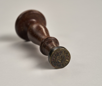 City of Greater Bendigo - Civic Collection
Ceremonial object - Common Seal, Shire of Marong, unknown
A seal is the corporate signature of an organisation. It is usually referred to as a ‘common seal’, meaning it represents a whole company ‘in common’, rather than any individual committee member, director or agent. A common seal can be used to signify the company or association’s authority or approval of a certain action, such as signing a legal document, or authenticating an award or certificate. It might also be used as the emblem or symbol of an organisation. This seal was for the former Shire of Marong now part of the City of Greater Bendigo.Circular, brass seal with wooden handle. Remnants of red wax remain in seal.Shire of Marongshire of marong, city of greater bendigo administration item -
 Learmonth and District Historical Society Inc.
Photo - Innes, Richards & Co. Photos Ballaarat, Councilor J.N.O.Innes,Councilor 1883-84, "circa 1884"
Councilor John.N.O.Innes was elected to council in 1878 - 87.He did not become President during that time.Section of Original photo of all councilors for the year 1883-84.This Sepia ,oval photo of Councilor John.N.O. Innes,is part of a collection of all councilors for the year 1883-84.It is in a light tan mount with "gold" edging around the photo and a fine black line around the "cutout".It is at the bottom left corner of the circle of photos.Councilor Innes name is inscribed under the photo. PRESENTED by the PRESIDENT,J. DALGLEISH ESQ. to the BALLAARAT SHIRE COUNCIL. 1883-84. ballaarat shire council, john n o innes 1883 84 -
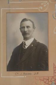 Learmonth and District Historical Society Inc.
Photo - Baird.J, Richards & Co. Photos Ballaarat, Councilor J.Baird.J.P.1911-12, "Circa 1912"
Councilor J.Baird J.P. was elected as a member of council in 1900 serving until 1928. He was Shire President in 1907-08,1916-17 and 1922-23.Original Historic Photo for 1911-12.Rectangular sepia photo of Councilor J.Baird,J.P, set in pinkish tan mount. It is placed at the top row left hand side of collection of photos of all councilors fot 1911-12. Councilor J.Baird J.P.ballarat shire council, j baird j p 1911 12 -
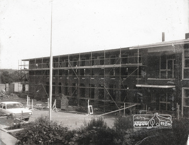 Eltham District Historical Society Inc
Photograph, Completing the south wing of Eltham Shire Offices for Library and Planning Departments, 1971, 1971
Completing the south wing of Eltham Shire Offices for Library and Planning Departments, Main road, Eltham. Building demolished 1990s.1 photographBack: "Shire Office extensions 1971" eltham, shire of eltham, eltham library, building, planning department -
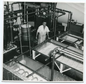 Orbost & District Historical Society
black and white photograph, mid 20th century
This photograph was taken inside the Orbost Butter Factory.The Orbost Butter and Produce Co. Ltd was registered on June 1st 1893 and was an important source of income to the Orbost district.A b/w photograph of a man in a white short-sleevedoverall standing behind vats of butter inside the Orbost Butter Factory. -
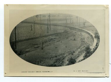 Orbost & District Historical Society
black and white photograph, Vogt. W.S, first half 20th century
In 1912 work was underrway on the Bairnsdale to Orbost railway. It was opened on April 10 1916. The two bridges on the railway viaduct, which crosses the Snowy River floodplain at Orbost, were built from local Southern Mahogany. The bridge on the Bairnsdale end (770m) is now the longest in Victoria. (info. Helen Martin)This item is associated with the history of the Orbost-Bairnsdale railway line and therefore reflects the role that the rail line played in the social and economic history of Orbost.A black / white photograph, oval-shaped on white background. It is of the railway viaduct across the flats at Orbost,.photo caption -"ORBOST RAILWAY BRIDGE, NEWMERELLA E. S. Vogt, Bairnsdale"newmerella orbost-viaduct east-gipsland-railway -
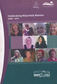 Eltham District Historical Society Inc
Book, Nillumbik Shire Council, Celebrating Nillumbik Women 2008-2013, 2013
This book was conceived by the Nillumbik Women's Network as a way of writing women into local history. When seeking nominations for the 2010 editon, the press release stated: Nillumbik Shire’s official histories don’t reflect the important but often unacknowledged contribution of local women to the development of the area. To redress this, the Nillumbik Women’s Network (NWN) initiated a small project, Celebrating Nillumbik women in late 2007.( For details of the Nillumbik Women’s Network refer to attachment) The NWN sought nominations of local women who had made, or continue to make, a significant contribution to the social and cultural life of our community. The brief profiles of the nominees were published in a booklet, which was launched at an International Women’s Day celebration in March 2008, and a second publication was produced in 2009. We continue to be inspired by the quality and activism of our local women. Many of the biographies tell of women’s contribution to the building of the ‘social’ infrastructure of the Shire. These stories complement the official historical accounts which primarily document men’s role in building the physical infrastructure of the Shire. One begins to develop a clearer picture of how women went about developing the services which we take for granted today, from the small kindergartens operating out of church halls to the wide ranging network of occasional and long day childcare care to the development of home based services for older frail and disabled residents of the area. They also tell of the bravery and resilience of women in their response to the devastating impact of the Black Saturday bushfires. This volume includes profiles of 23 women, 2013 Nominees in addition to those included since the project was launched in 2008. The 2008 nominations are: Wendy Alexander, Jane Ashton, Sharon Banner, Janet Boddy, Catherine Cervasio, Belinda Clarkson, Helen Coleman, Cathy Dean, Judy Duffy, Gwen Ford, Jenny Graves, Cath Giles, Meera Govil, Ona Henderson, Jill Jameson, Vicki Kaye, Mrs Kimber, Nerida Kirov, Jane Lauber, Pam Lawson, Anne Manne, Chris Marks, Elizabeth Marshall, Dawn McDonnell, Jenny Millar, Grace Mitchell, Jenni Mitchell, Michelle Molinaro, Joy Murphy, Rosie Murphy, Barbara Murray, Tracey Naughton, Josephine Norman, Pamela Pederson, Mary Robertson, Vicki Ruhr, Geraldine Sanderson, Dawn Shaw, Fiona Sievers, Myra Skipper, Selina Sutherland, Barbara Talbot, Marjorie Taylor, Julie Tipene-O’Toole, Susie Walker, Donna Zander. 2009: Jan Aitken, Rosemary Aitken – OAM, Edith Apted, Betty Anderson, Thelma Barkway, Diana Bassett-Smith, Jenneke Bateman-Korteweg, Amy Bryans, Sabi Buehler, Jenni Bundy, Audrey Cahn, Linda Cornelissen, Janice Crosswhite, Elean Dansey, Christine Durham Claire Fitzpatrick, Ailsa Fitzmaurice, Lucinda Flynn, Sheryl Garbutt MP, Fran Gronow, Ev Hales, Irene “Rennie” Harrison, Ena Jarvis, Heather Kaufmann. 1948-2007: Helen Kenney, Margot Knox – Pederson, Lois Loftus-Hills, Nina Mikhailovna Christesen AM (nee Maximov), Penny Mullinar, Gwayne Naug, Nanette Oates, Lisal O’Brien, Stella Reid, Laura Rohricht, Meg Russell, Sonia Skipper, Bronwyn South, Pauline Toner MP, Lisa Walton, Diana Warrell, Rachel Watt. The 2013 nominations are: Roslyn Addison, Sue Aldred, Lucy Anderson, Sue Arnold, Mary Avola, Anna Foletta, Morag Fraser, Danielle Green MP, Colleen Hackett, Pam Hayes, Barbara Joyce, Carol Leeson, Sandra and Bruce Poloni, Many Press, Carolyn Royse, Hannah Sky, Lorna Smith, Lynlee Tozer, Kilanthi Vassiliadis, Kerry Wailes, Gale Weiss, Irma Winton and Alexis Wright.This book is a significant in the recording of the contribution of local women to the development of the Shire of Nillumbik, especially for the time frame 2008 -- 2013. Historically women's stories generally have not been told at all, let alone their contributions acknowledged. This book profiles and documents women's stories that otherwise may not have been told.women, nillumbik women's network -
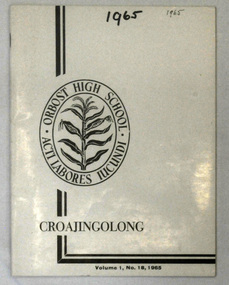 Orbost & District Historical Society
magazines, Croajingolong 1965, 1965
This is the eighteenth issue of the annual Orbost High School magazine. The name Croajingolong derives from the Australian Aboriginal Krauatungalung words galung, meaning "belonging to" and kraua, meaning "east". 2213.1 belonged to Mary Gilbert, a former teacher at the school. 2213.2 belonged to Brenda Murray, a former mayor of East Gippsland Shire and a prominent Orbost resident. This magazine is a useful reference tool.Three copies of a white covered magazine with black print : Croajingolong Vol.1 No. 18 1965. On the left side is the Orbost High School badge, a sheaf of corn inside a double oval which contains the school motto, " acti labores iucundi".on front cover of 2213.2 - Brenda Murray handwritten in pen.