Showing 23103 items matching "sardine-creek"
-
 Stawell Historical Society Inc
Photograph, Stawell Water Supply Fluming over the Bovine Creek. Same as 0360
Stawell Water Supply Fluming Bovine Creekstawell flume -
 Kew Historical Society Inc
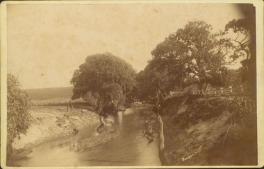
Photograph - Bryants Creek, Coleraine, 1892-3
This item is part of a larger collection donated to the Kew Historical Society by Anna French. The collection includes personal items from the donor's family, as well as items given to the donor and her mother by a family friend, Lucy Merritt (Jean) Hornby. The item is from that part of the collection inherited or assembled by Jean Hornby. The collection is significant given Jean Hornby's mother's descent from Robert Hornby (1854-1935) and Eva Merritt (1865-1959); her mother the chid of a family who settled in Kew in the 1850s, thus providing a chain of provenance for items dating to the mid-nineteenth century, when her maternal forebears arrived in Melbourne. Other items represent Jean Hornby's contribution to her local and wider community.Sepia photograph, labelled 'BRYANTS CREEK' at lower left. The creek is bordered by a white post and rail fence on one bank. On the other side of the creek are two men. The creek is bordered with remnant vegetation [ie Eucalypts]. Coleraine, in Western Victoria, was initially settled by Europeans in the 1840s. The developing township was aligned with Bryant's Creek with a north-south orientation. Reverse - Inscribed in ink: "Taken by H Bower with Student camera" / Printed: "C.G. Greenham Photographer, Hawthorn / The Herodotus Studio"bryants creek -- coleraine (vic.) -
 Upper Yarra Museum
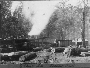
Negative Photographic Reproduction, E Lloyds Mill, Hoddles Creek, 13/4/1983
This looks like a typical Bush Timber Mill of the period, E Lloyd's Mill, Hoddles Creek Negative Black white. Scanned at 600 dpi. There are five men at work at the mill and also a lady sitting on the front verandah of the nearest hut, possibly mending some material , there are 2 other. hutse lloyds mill timber workers women hoddles creek logs sandy ross -
 Southern Sherbrooke Historical Society Inc.
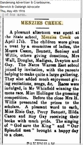
Article - Menzies Creek State School article, Menzies Creek
An article from the Berwick and Oakleigh Advocate dated 4th May 1916, reporting an afternoon gathering at the Menzies Creek State School held on 17th April 1916. Narre Warren East State School was also invited to join the afternoon. -
 Falls Creek Historical Society
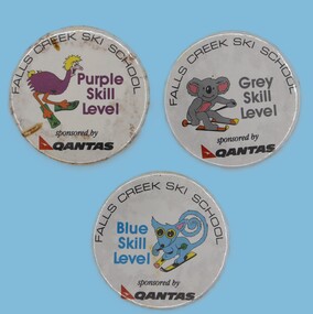
Badge - Falls Creek Ski School Level Badges
This item is from the private collection of George Shirling of Red Onion, Falls Creek. The badges were awarded to participants who achieved different levels of the Falls Creek Ski School as part of the Junior program. George Shirling arrived in Falls Creek in 1962. He engaged Phil Nowell to build the original Koki Alpine Lodge which opened in 1965 with 14 beds. George operated the lodge with Michael “Baldy” Blackwell as manager. He also graduated in sport psychology in 1981 and was invited to become team psychologist for the Australian Winter Olympic team which went to Albertville, France, in 1992. He later owned the Red Onion Chalet. George credited the success of Koki to “Baldy” Blackwell. “Baldy” and Phil Nowell started the Trackers Mountain Lodge in partnership during the 1980s. In 1971 George sold Koki Lodge to Sigi Doerr. In 2024 the renamed Koki Alpine resort remains a highly popular destination in Falls Creek. George Shirling passed away on 27th February 2023. He had remained actively involved in Falls Creek and was generous with his time and knowledge, always an amazing supporter of The Falls Creek Museum and Falls Creek Village.This item is significant because the badges recognise progress through the Falls Creek Ski School Program.A set of metal badges awarded for progress through the Ski School Program. Each level is represented by an different Australian animal. The program was sponsored by QANTAS.george shirling, falls creek -
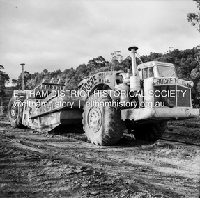
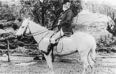 Eltham District Historical Society Inc
Photograph, Mr Yates, Clerk of the Course for the Diamond Creek Racing Club, c.1880
Photo from J. Sinclair reproduced on p92 of The Diamond Valley Story by Dianne H. Edwards, Shire of Diamond Valley 1979. "Mr Yates of Pine Grove, Upper Diamond Creek was the local postmaster, and Clerk of the Course for the Diamond Creek Racing Club in the 1880s. He is dressed for a meeting - the coat was scarlet. When racing ended at Diamond Creek in the 1890s he became Clerk of the Course at the Yarra Glen track."Black and white copy of photo printed on glossy photographic paper 30.5 x 40.5 cm (12 x 16 inch); image size approx. 18.5 x 28 cmclerk of the course, diamond creek racing club, diamond valley story, horse, mr yates, pine grove, postmaster, upper diamond creek -
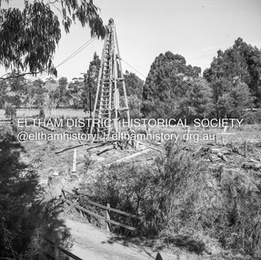
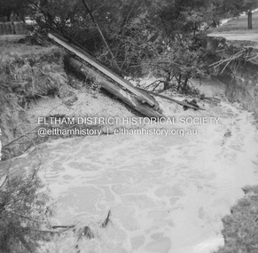 Eltham District Historical Society Inc
Album - Photograph, J.A. McDonald, Dixons Creek Road, 23 Sep. 1955
Dixons Creek in flood Temporary bridge washed outRecord of various Shire of Eltham infrastructure works undertaken during the period of 1952-1962 involving bridge and road reconstruction projects, sometimes with Eltham Shire Council Project Reference numbers quoted. It was during this period that a number of significant improvements were made to roads and new bridges constructed within the shire that remain in place as of present day (2022). In many situations, the photos provide a tangible visible record of infrastructure that existed throughout the early days of the Shire. The album was put together by or under the direction of the Shire Engineer, J.A. McDonald.1955-09-23, bridge construction, dixons creek bridge, dixon's creek road, flood damage, floods, infrastructure, road construction, shire of eltham -
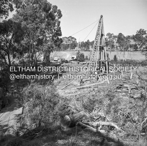
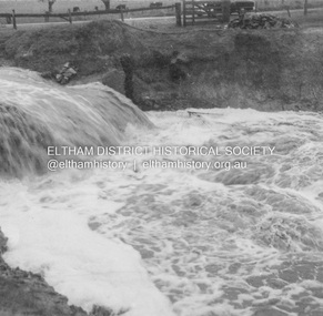 Eltham District Historical Society Inc
Album - Photograph, J.A. McDonald, Dixons Creek Road, 21 Oct. 1953
Scour on Dixons Creek Road 21st October 1953Record of various Shire of Eltham infrastructure works undertaken during the period of 1952-1962 involving bridge and road reconstruction projects, sometimes with Eltham Shire Council Project Reference numbers quoted. It was during this period that a number of significant improvements were made to roads and new bridges constructed within the shire that remain in place as of present day (2022). In many situations, the photos provide a tangible visible record of infrastructure that existed throughout the early days of the Shire. The album was put together by or under the direction of the Shire Engineer, J.A. McDonald.infrastructure, road construction, shire of eltham, bridge construction, dixons creek bridge, dixon's creek road, 1953-10-21 -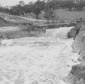
 Kiewa Valley Historical Society
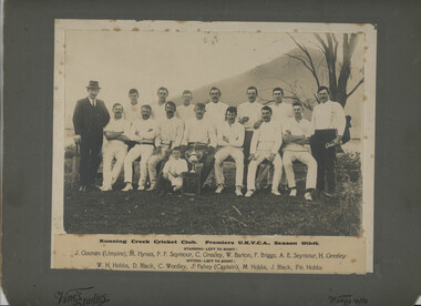
Photo - Running Creek, Photo - Running Creek Cricket Club Premiers UKVCA, Season 1913-14
Running Creek had a cricket team in 1913-14.The donor Genieve was the granddaughter of Ella Sullivan. Ella was one of 5 daughters of Denis and Margaret (nee Tolmie) Sullivan who lived at Tawonga (Coral Bank). 'Sullivan's Lane'. Ella married John (Jack) Fahey and they lived for some time at Fahey's Lane, Running Creek. J. Fahey is listed as Captain in the photo. The child's name is not known but it is possible it's Jack's son by the sitting position.Sepia coloured large photo of 13 Cricketers and 2 men, one at each end. Underneath the photo is the name of the event and the names of the cricketers and umpire. The photo is mounted on grey cardboard with 'Vine's Studios' and 'Wangaratta' inscribed. running creek, cricket team in 1913-14 in the kiewa valley, genieve meyer -
 Stawell Historical Society Inc
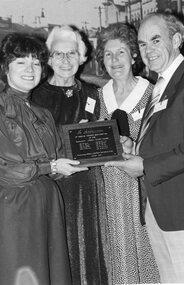
Photograph, Presentation of Restoration Plaque for the Pleasant Creek Court House
Presentation of Restoration Plaque (Pleasant Creek Court House)stawell -
 Stawell Historical Society Inc
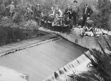
Photograph, Grampians Fyans Creek Weir for the Stawell Water Supply
Grampians Fyans Creek Weir (Stawell Water Supply)stawell -
 Stawell Historical Society Inc
Photograph, Greens Creek School Number 1381 1927
New School - Greens Creek No. 1381 opened 1927stawell education -
 Stawell Historical Society Inc
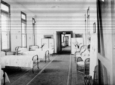
Photograph, Pleasant Creek -- Stawell Hospital Syme Ward Interior
Pleasant Creek. Stawell Hospital Inside of Syme Ward stawell hospital medical -
 Stawell Historical Society Inc
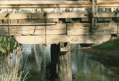
Photograph, Salt Creek Bridge's detailed Pile Head 1993 -- Coloured
Detail of Pile Head Salt Creek Bridge 1993stawell -
 Stawell Historical Society Inc
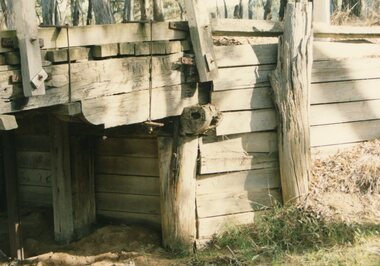
Photograph, Salt Creek Bridge's detailed Pile Head 1993 -- Coloured
Detail of Pile Head Salt Creek Bridge 1993stawell -
 Stawell Historical Society Inc
Photograph, Pleasant Creek Court House in derelict condition 1974 -- Coloured
Pleasant Creek Court House in derelict condition 1974stawell -
 Stawell Historical Society Inc
Photograph, “Cheshire Park" Homestead at Greens Creek 1985 -- 7 Photos -- Coloured
Seven Scenes. “Cheshire Park” - Greens Creek 1985stawell -
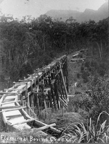 Stawell Historical Society Inc
Photograph, Stawell Water Supply fluming at Bovine Creek in the Grampians. Same as 1443
Grampians - Stawell Water Supply fluming at Bovine Creek -
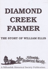 Greensborough Historical Society
Book, Diamond Creek Farmer, 1994
History of the Ellis family in Diamond Creek and Yarra Glen.William Ellis emigrated to Victoria in 1847 and bought most of the Wattle Glen area in 1850. He also had family connections to Kangaroo Ground.A black and white booklet, 12 pages, black and white illus.John Mackey in pencil inside front coverwattle glen, kangaroo ground, nillumbik historical society, william ellis, diamond creek, farming, walters family, ellis cottage -
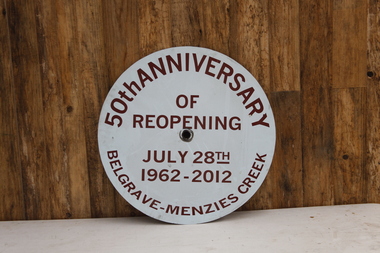 Puffing Billy Railway
Locomotive Head Board - 50th Anniversary of the reopening to Menzies Creek from Belgrave July 28th 1962 - 2012, 2012
Historic - Puffing Billy Railway Locomotive Head Board - used in the Celebrating the 50th Anniversary of the re-opening of Puffing Billy between Belgrave & Menzies Creek held on Saturday 28th July 2012Historic - Puffing Billy Railway Locomotive Head Board - used in the Celebrating the 50th Anniversary of the re-opening of Puffing Billy between Belgrave & Menzies Creek held on Saturday 28th July 2012Locomotive Head Board - 50th Anniversary of the reopening to Menzies Creek from Belgrave July 28th 1962 - 2012 Tin sign with blue and burgundy vinyl.50th Anniversary of reopening July 28th 1962 - 2012 Belgrave - Menzies Creek puffing billy, head board -
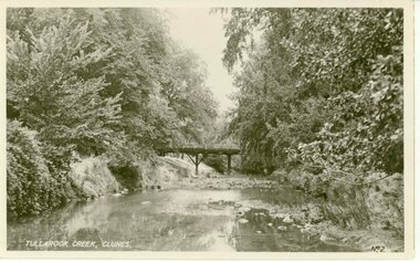 Clunes Museum
Photograph
THIS BRIDGE WAS DEMOLISHED IN 1962 AND A NEW BRIDGE WAS ERECTED.BLACK AND WHITE PHOTOGRAPH OF JUBILEE OR QUEEN'S BRIDGE OVER TULLAROOK CREEK, CLUNES.TULLAROOK CREEK, CLUNESlocal history, photography, photographs, bridges -
 Eltham District Historical Society Inc
Negative - Photograph, J.A. McDonald, Yarra Glen-Yea Road, Dixons Creek, June 1958
Dixon's Creek Yarra Glen-Yea Road June 1958Record of various Shire of Eltham infrastructure works undertaken during the period of 1952-1962 involving bridge and road reconstruction projects, sometimes with Eltham Shire Council Project Reference numbers quoted. It was during this period that a number of significant improvements were made to roads and new bridges constructed within the shire that remain in place as of present day (2022). In many situations, the photos provide a tangible visible record of infrastructure that existed throughout the early days of the Shire. The album was put together by or under the direction of the Shire Engineer, J.A. McDonald.infrastructure, shire of eltham, 1958-06, bridge construction, dixons creek bridge, dixon's creek road, yarra glen-yea road -
 Eltham District Historical Society Inc
Negative - Photograph, J.A. McDonald, Laidlays Road, Arthurs Creek, April 1962
Bridge over Arthurs Creek Looking east April 1962Record of various Shire of Eltham infrastructure works undertaken during the period of 1952-1962 involving bridge and road reconstruction projects, sometimes with Eltham Shire Council Project Reference numbers quoted. It was during this period that a number of significant improvements were made to roads and new bridges constructed within the shire that remain in place as of present day (2022). In many situations, the photos provide a tangible visible record of infrastructure that existed throughout the early days of the Shire. The album was put together by or under the direction of the Shire Engineer, J.A. McDonald.1962-04, arthurs creek, bridge construction, infrastructure, laidlays road, shire of eltham -
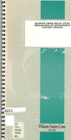 Greensborough Historical Society
Booklet, Wilson Sayer Core Pty Ltd, Diamond Creek retail study: preparation of development concept options, August 1989
Planning options for an extended retail development in Diamond Creek 1989.12 p. text, 12p. plans, spiral bound non-fictiondiamond creek, shire of diamond valley, retail developments -
![Newspaper clipping, Ode To My Suburb [Diamond Creek], 12/09/2012](/media/collectors/4f729f5697f83e03086015b8/items/52310c712162ef26c44f005e/item-media/52539b042162ef15c0b9aeb7/item-fit-380x285.jpg) Greensborough Historical Society
Greensborough Historical SocietyNewspaper clipping, Ode To My Suburb [Diamond Creek], 12/09/2012
The article describes the memories of the author growing up in Diamond Creek.The article features 8 photographs of sites around Diamond Creek.A one page multi coloured article from the Weekly Review of 12/09/12.Nildiamond creek, cemetary gates, netball court, swimming pool, windmill residence, footbridge, challenger st, a.d. ryans, st johns, 3089 -
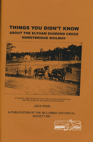 Eltham District Historical Society Inc
Book, Nillumbik Historical Society, Things You Didn't Know about the Eltham Diamond Creek Hurstbridge Railway, by Jock Ryan, 2003
Brief history of Eltham Diamond Creek Hurstbridge railway line10p, 30 cm -
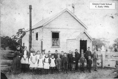 Stawell Historical Society Inc
Photograph, Greens Creek School Number 1381 c1880's
School - Greens Creek No. 1381 1880's with students and teachers.stawell education -
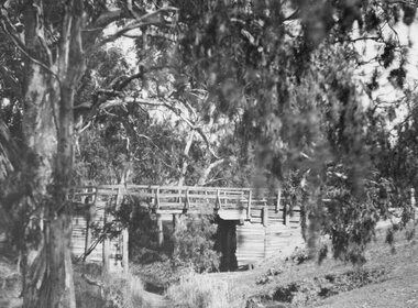 Stawell Historical Society Inc
Photograph, Old wooden Bridge over Dog Trap Creek in Callawadda
Old wooden Bridge over Dog Trap Creek - Callawaddastawell