Showing 1992 items
matching st george
-
 Glen Eira Historical Society
Article - SHELFORD GIRLS’ SCHOOL AND KINDERGARTEN
... Thompson Debbie Mrs Rome Lorraine Wilson Lorraine St Georges Road ...This file contains 2 items relating to school magazines and publications: 1/1 photocopy of a page from the school magazine ‘Quaerite’, 1968, with a photograph of many students in front of the assembly hall and an article about the opening of the assembly hall on 05/06/1968 author unknown. 2/1 copy of the Shelford Old Grammarians publication ‘GOSSIP’ (Grammarians of Shelford Social Interest Paper) issue no. 85, dated 1st quarter of 1988. The publication includes details about the running of and events held by the Shelford Old Grammarians as well as details about the lives of former Grammarians. Written by David Waxman.shelford girls’ school and kindergarten, schools, openings (events), delacombe rohan sir, woods dr. archbishop, choirs, orchestras, musical events and activities, dances and balls, stevenson nan, henderson margot, pianos, old grammarians association, shelford old grammarians, ‘grammarians of shelford social interest paper’, ‘gossip’, anderson jean mrs, olinda street, caulfield south, thompson debbie mrs, rome lorraine, wilson lorraine, st georges road, elsternwick, guala lynne, parke lynne, halstead simone, barrington street, bentleigh east, kendall debbie, webb jean, deller lynne, franzoni lynne, brown nola, jenkinson nola, nelms jenny, bond jenny, waite janine, brown helen, clubs and associations, meetings, events and activities, sport, gleadell linda, koch linda, barbecues, dawson sally, richards sally, richards bronwyn, barnacle bronwyn, crocker susan, waxman susan, hosford margaret, hoult margaret, francis dyanne , franzoni dyanne, baxter dorothy, scott maureen, ahearne robyn, summer louise, ballantyne robyn, hill robyn, painsh elizabeth, mayne lyn, eshelby shirlene, looker margaret, hunter dale, martin colleen, evans julie, froomes vicki, plaisted leonie, leah leonie, pull lisa, patxy godby, currer liz, crawshaw pam, shaw debbie, milner cheryl, hopkings wendy, tietgens jenny, gill janet, edwards leigh, hannon lisa, folley melinda, sport, bray jennifer, birch jennifer, graham sally, smith sally, bosquet rue, masters anne, dalton anne, murray michele, brown michele, sutton kaye, griffiths kaye, faragher sue, butterfield anne, thompson anne, cassidy julie, lynes yvonne, van buuren vanessa, vanselow elizabeth, hall elizabeth, riley vicki, rowed elizabeth, strugnell peter, caulfield grammar school, graham andrew, murray peter, hoad ian, amos emma, carr vanessa, mallaby kirstienne, valentine karen, calderwood jan, perkins jan, perkins jan, humphries karen, asher kim, hannon lisa, mardardy mischel, sanford belinda, sherlock natalie, barklamb kate, levy sally, mathew jennifer, stahmer sally, gray mrs, australia day, howell marilyn, harley robyn, elms liz, johnston liz, mcilveen bronwyn, calderwood simone, zacharin pat, williamson pat, waite pamela, wilson pamela, perkins jan, woodburn bettina, bromley bettina, stuchbury leanne, dalton sue, dalton leigh, myers jean, sligo pam, gibson pam, collins sue, baddams miss, limb lois, rice lois, bishop myra, planner betty, planner pam, smart arlie, lambert dorothy, goode sandra, harris margaret, chamberlain margaret, elms elizabeth, johnston elizabeth, rome lynne, waxman dawn, clements dawn, weddings, halls -
Glen Eira Historical Society
Document - LECHTE, WILLIAM LUDWIG SAMUEL SEBASTION
... . Benjamin Murray Mr. Moore Mr. ‘Glenfern’ St. Georges road Glen ...3 items about this person: 1/Two twelve page carbon copied documents, purportedly written by William Letchte, son of George, written in c1935/36. He writes of his jobs as a dairyman, cow minder at the age of ten tears. He recollects streets, people, residences, business and general landscape in the area, as he takes you on a tour of the area. 2/Photocopied photo of Katrina Lechte (nee Bolch?) donated by Ian Lechte, 15 Adrian Street, East Bentleigh. 3/Photocopied copy of first pages and cover of William Lechte’s booklet on ‘Caulfield 1869 – 1935 Memories of the Past’, published by the City of Caulfield, 1992. The Society has the full booklet in its book collection (not yet catalogued as of 07/07/2015).grange road, glenhuntly, glen huntly station, alma road, dairies, caulfield park, swamp, queens avenue, station street, cross street, racecourse, heywood j. g., turf club hotel, dandenong road, royal hotel, koornang road, north road, murrumbeena road, mclaurin archibald, crosbie j. w., poath road, newton mr., hooker mr., peck family robert farmer, dairies, ross murray, rosstown, hansen hans, arnott family, peppin family, ormond station, malane family, fraser simon, overtons, shepherds, spring road, mohlers, brighton cemetery, mall kim, market gardeners, long john farmer, fiedler mr., booran road, reservoir, summers mr., maddocks mr., holland mr., caulfield council, glen eira road, harriman benjamin c., kambrook road, bambra road, princess park, marriott john, hawthorn road, brickworks, hyam mr., cottages, jasmine street, sycamore street, paddy o’briens swamp, arnold tom, london tavern hotel, guess john-grocer, topp mr., poath road, pine trees, colonel le marehand, balaclava junction, chemist shop, bell mr., nicholls mr. william h., wine shop, orme mr., pepperorn mr. john, balaclava road, orchards, harvey mr. robert tailor, schubert mr., blew charlie – gardener, philpott mr. richard b., farquhar mr. william farmer, newing t. r., glen eira road, payne john, brockhoft mr., dickson mr. james, snipe t., bevan mr., mckean family john, murray family, francis mr., hart mr., mcdougall james, brady peter, cad, elsternwick station, webb mr., masters mr. samuel, master street, ford mr., anderson mr. joseph gardener, slaney mr., boxhill mr. richard, post office, newsagent, hotham street, service james, bunn mr., sargood mr., orrong road, arnold tom – dairy, officer mr., grimwade mr., alexandra street, oakleigh hall, degraves mr., wilson samuel, ‘manifold’, house names, miller septimus, alma road, knox mr. james gardener, smith mr., coachman, ‘cumloden’, lange mr., holyrood justice mr., cronin mrs. mary, mcgivenys dairy, ‘belle vista’, lloyd c. d., caulfield council, hughes mr., armstrong j. a., tom healey’s market garden, kooyong road, inkerman road, tom roe’s market garden, mcleod captain, daish captain, plumridger mr. frederick, gardeners, tester mr. thomas, kent mr., kent g., fiddes mr., billings mr., semple mr., fosberry mr., howitt or., merrett mr., orchards, hawthorn road, hines mr., ‘rosecraddock’, langdon h. j., ‘crotonhurst’, webb justice mr., renwick s., ‘garrell’, barry mr., drinsdale family, st. mary’s church, sunday school, newing miss, teachers, stephen justice mr., stephen wilberforce, mount l., grimwade’s, ‘grimwade house’, danby’s, spence mr., venables family, mr. moss’ congregational church, barnhill mrs., porter miss, webb’s, ferguson, orange, police stations, kooyong road, pennington mr., health inspectors, engineers, inkley mr., farriers, mckeon mr., ‘sylverly’, dixon mr. edward, turner mr., marriott robert, ‘ravenhurst’, thompson j. j., wott t., architects, perrin mr. francis, tennis courts, royal parade, sayce mr. joseph j. p., ricketson h., ‘glen eira’, mansions, hospitals, turner mr., evans family, stephens miss, registers, mcculloch lady, convalescent homes, prentice street, edward street, strickland, keany pat, brentwood charlie, fordham lewis, hopetoun gardens, higgins mr. joseph f. engineer, railway construction bill, evans mr., beavis mr., twycross family john, medina captain, cowderoy mr. benjamin, murray mr., moore mr., ‘glenfern’, st. georges road, glen huntly road, cedar street, hunt bill – ‘bandy hunt’, jessamine street, alder street, le page’s store, post offices, balaclava junction, stephens frank, solicitors, parkside street, robinson j., ilbery mr. and family, mclennan mrs., victoria street, savings bank, riddell parade, elworthy mr. richard, butchers, shaw mr. william, armstrong mr., guess’ hotel, sycamore street, bagshaw mr., clack joe, wawn alex, sisson family, north road, younger mr., kooyong road, sheridan joseph, anketell family – john, wren john – carpenter, wills mr. peter, attrills arnold, heffernan family, cox peter, ilbery john, hotham street, glen huntly road, page j. w., bakeries, forests, godfrey mr., blacksmiths, thompson j. j., olive street, cedar street, letchte w., tierney richard, alma road, st. kilda east, murray peter, letchte’ cows – grazing, holland grove, eskdale road, lechte katrina, lechte ian, lechte catherine, lechte warren, lechte stuart, lechte elaine -
Glen Eira Historical Society
Document - BRIGHTON GENERAL CEMETERY
... George Elsternwick St. Clements Sproule Mary Elizabeth Sproule ...This file contains a six-page handwritten list of tombstone inscriptions from a select number of graves at the Brighton General Cemetery, dated August 1973 and 10 11 1973, author unknown. Details include names and date of death, with some entries also stating date of birth, family relationships, the mason of the tombstone and other significant details relating to the internment. A short handwritten note is attached to the end of the list, of what appears to be details of four internments in the INDEPENDENT section of the cemetery, including crossed-out details previously mentioned in the list.cemeteries, brighton cemetery, ricketson sophia, ricketson henry joseph, ricketson georgina sherbourne, ricketson olive elaine, a and c ballantyne, ballantyne a, ballantyne c, stonemasons, grimwade edward norton, grimwade phelia maude, casey james joseph, tope h., 4 tope and co., dempsey. isabella, dempsey william james, caulfield, huxley parker and co., liddiard henry w.w., liddiard anna susanna, stark robert m., ford sarah, ford henry, ford elizabeth, bent thomas, bent elizabeth, bent gertrude huntley, bleazby elizabeth h., people by circumstance, huntley john jnr., shand mary, kentucky, irving william, irving winter, noorilim, dandenong road, irving frances amelia, miller septimus, miller clara johnstone, miller gwendoline, stone robert, pearson william, pearson eliza laura, craigellachie, pearson hugh, pearson henry travers, pearson alexander buchanen, pearson hugh boyd, pearson alex l., webb charles, webb emma, webb ethel mary, the poet gordon, gorden annie lindsay, langdon william, langdon constance annie, langdon h.j., langdon ell, langdon john barry, langdon george rupert webb, langdon frank harry webb, langdon w.f., langdon s.s.a., langdon dottie, langdon william farquhar, croton hurst, higginbotham george, higginbotham edith, morris edith, morris edward e., reade maude, sproule george, elsternwick, st. clements, sproule mary elizabeth, sproule may, sinnatt farley, stanley henry, stanley mary elizabeth, todman madge brown, todman charles, long john, fox e. phillip, trott harry, plaques, boyd pamela, boyd theodore penleigh, artists, clarke alice lovell, bishops court, bevan ann, bevan philip, bevan margaret maybery, bevan richard, bevan amy constance, bevan laurie adelaide, ormond -
 Glen Eira Historical Society
Photograph - CAULFIELD CENTENARY 1957
This file contains two items 1/Forty-three black and while photos of various Caulfield Centenary celebrations 1957 including the naturalisation ceremony, a council meeting, centenary queens, fireworks, bands and parades and processions. The photographs are stamped with Herme’s Studios, 356 Neerim Road, Carnegie UM 3436 Photographer and exact dates are unknown. 2/Six black and white photos of various Caulfield Centenary celebrations 1957 including a carnival and fireworks. The photographs are stamped with S.T. Deans Photographer 33 Alma Road St Kilda.naturalisation ceremony, caulfield centenary, herme’s studios, s.t. deans photographer, sinclair a. george, neerim road, alma road, city hall, council meetings, parades and processions, centenary queen crowning ceremony, fireworks displays, cycling, festivals and celebrations, ferris wheel, bands, parade of decorated floats, marching girls, chinese dragon, special centenary council meeting, caulfield centenary carnival -
Glen Eira Historical Society
Book - CAULFIELD CENTENARY 1957
... ’ ‘St. Aubin’s’ ‘Caulfield Hall’ Caulfield John P.T. St Georges ...This file contains four items 1/Two copies of a twenty-four page booklet titled CITY OF CAULFIELD CENTENARY 1857-1957, created by the Caulfield City Council and printed by Peter Isaacson Pty Limited, Melbourne. The booklet details important aspects of Caulfield’s history including council procedures, the Caulfield Road District Proclamation, the first election and a summary of 100 years of local government with a description of the present Caulfield in 1957. The booklet also includes several pictures of various Caulfield landmarks and people including one of Caulfield City Councillors (11 men and 1 woman). Also one photocopied version of this booklet. 2/Eleven pages of typed notes for the City of Caulfield Centenary booklet. All notes are undated and incomplete. Two pages titled NOTES on THE HISTORY and PROGRESS OF THE CITY OF CAULFIELD, author unknown. Three and a half pages titled THE STRUCTURE OF LOCAL GOVERNMENT IN VICTORIA, author unknown. Five pages titled 100 YEARS OF LOCAL GOVERNMENT – EARLY CAULFIELD, by Mrs A. P. Bell. 3/A typed letter to Miss V. Webb-Langdon from the Town Clerk H.G. Nelson, acknowledging her contribution to historical details for the Caulfield Council’s Centenary booklet, dated 24/12/1957. 4/A handwritten letter and a handwritten note regarding the acquisition of notes for the Caulfield Centenary booklet. The letter is dated 03/08/2006 and the note is dated 09/02/2007.city of caulfield centenary, caulfield road district, sinclair a.j.g., city hall, war memorials, gamble h.a., machin l.r., bunny f.c.d., caulfield park, koornang reserve, parton e.m., sims h.e., thomson w.r., gunn e.e., yorston j.s., wallace g.e. mrs, green w.c., jenner e.r., ward boundaries, dandenong road, queens avenue, normanby road, station street, bond street, glen eira road, orrong road, poath road, north road, booran road, nepean highway, glen huntly road, glenhuntly road, inkerman road, hotham street, nelson h.g., fullard w.r., mackley g.j., ellis k.i, crosbie m.r., nutting b.i., body j.h., pritchard r.j., guildford l.t.g., lund l.m., street h.c., reynolds a.w., elections , political processes, local government, springthorpe reserve, greenmeadows gardens, business and finance, roads and streets, caulfield racecourse, east caulfield reserve, mackinnon reserve, hawthorn road, balaclava road, murrumbeena road, lempriere avenue, victoria street, koornang road, lord reserve, lyons street, murrumbeena reserve, kangaroo road, ormond park, beatty crescent, foch street, packer reserve, oakleigh road, leila road, prices park, bambra road, riley reserve, playgrounds, town hall, maternal and child health centres, truganini road, grange road, senior citizens centre, barkley sir henry, moore david, handasyde gilbert, caulfield school room, harris g.w., semple john, dempsey william, brooks w.a., wilson thomas, lyall william, murrum murrumbeen lifestyle, ‘greenmeadows’ house, lempriere family, aboriginal culture, ‘rippon lea’ house, caulfield john, ‘slaney’s’ home, alma road, paddy’s swamp, racecourse hotel, caulfield technical college, bevan mr., ‘grosmont’, hart john, railways, mansions, ‘rosecraddock’, langdon h. j., caulfield cup, ‘crotonhurst’, webb judge, ‘kilwinning’, service james, ricketson henry, ‘glen eira’, house names, garden vale, ross william murray, ‘ross’s folly’, outer circle railway, caulfield grammar school, davies j. henry, lagdon william, grimwade f.s., loyd charles du plan, hope george, ‘airdrie’, kooyong hill, market gardens, dairies, lady talbot milk supply, jenner family, o’niell college, presentation sisters, glenferrie road, grimwade frederick sheppard, grimwade alice, ‘harlston’, grimwade house, ‘saint aubin’s’, ‘st. aubin’s’, ‘caulfield hall’, caulfield john p.t., st georges road, caulfield military hospital, nursing homes, health establishments, dover street, sports and recreations, rosanna street, ‘cantala’, health services, parks and reserves, community services, town planning, local government finance, local officials and employees -
Glen Eira Historical Society
Document - CAULFIELD CITIZENS ADVICE BUREAU
This file contains 2 items: 1/Original copy of 17th Annual Report of city of Caulfield Citizens Advice Bureau September 1987. Report includes Agenda for the Annual General Meeting held at City Hall on Wednesday 30091987, list of office bearers, minutes of the previous AGM, election of Management Committee and presentation of Life memberships plus list of Legal Advice Service solicitors. 2/Original copy of Agenda and 25th Annual Report for Caulfield Citizens Advice Bureau Incorporated presented to the Annual General meeting on 30/08/1995 at Caulfield City Hall. Report includes financial statement F Y E 30/06/1995, details of President’s Report, minutes of previous AGM in 1994.caulfield, citizen’ advice bureau, meetings, caulfield city hall, annual report, grants, edwards mavis, hocking john, green carol, coad thelma, harry carol, hession dorothy, lambert sam, moorrees joyce, ravenscroft jean, rowland dorothy, tyrell audrey, snowball betty, telford nancy, jelleff jenny, kay yvonne, bannister jean, fooks john, allsop doris, bullivant trudy, capek irene, carr fred, cairncross gwen, gorden peg, daniels maurice, davey dulcie, gresham greta, gresham john, hicks margaret, hind lillian, jacombs ken, joseph marion, kinross jo, lukies arthur, lukies noela, mander clive, miles glad, moser ellen, popper irene, poynton ray, splatt betty, stewart may, telford nancy, wray shirley, watson beth, chapman john, felder ilse, helman anne, mccarthy marie, richardson elizabeth, steward derek, williams marcia, blacher rosa, heyman manfred, tanner ted mla, dunstan don. cr, martens veronika cr, legge mary, crossley rosemary, malvern citizens’ advice bureau, deal communication centre, child joan mp, macphee ian hon mp, shipton roger mp, mccutcheon andrew mla, campbell jack, mayor, mayoress, campbell mrs., rudzki brian cr, milne sandy, fusion, moyle gwen, westlake margaret, gild anne, herszfeld henry, lee alf, lee rae, peters leanie, pratt lillian, trumble joan, wise john, nicholls harry, grist molly, payne ruth, victorian association of citizens’ advice bureaus, emergency relief funds, community buses, sinisgalli john, aroni beni, chisholm john, erlichster george, folkers herman, jackson ross, kraus michael, lewis ray, oliver michael, romer andrew, simons adrian, smith simon, legal advice services, solicitors, budget advisory service, voluntary workers, sanders kathy, allan bill, bible richard, bilston ron, birch harry, coad laurie, durra frank, glass alf, gild ann, grew doreen, hawker harry, hollow neil, hingert lorna, jack ian, jones alf, mann gordon, mansfield joan, marks yvonne, menzies edna, ohis wil, powell dave, pate gwen, pentland dilys, simmons dianne, ward george, whitehead richard, wills anne, local government, aged people, bullen rose, culkan stephanie, dukes claire, klinger rosa, lambert douglas, sheehan jean, trodd carrie, brady vera, bristow joyce, byrne enid, cornall-reilly patience, cornall-reilly arthur, rowland alan, caulfield city council, hostels, elsternwick, caulfield festival, caulfield park, maple street, st. johns uniting church elsternwick, caulfield contract, regent community for the elderly, caulfield hospital, royal district nursing service, mence wendy, gubieski joanne, preston dennis, ross moya, hall chloe, patience geoff, o’reilly mary, wraight geoff, thompson john, britton cath, thompson laurel, ross erwin, chapman john, carnie elza, coutts fay, goodman dianne, groat shirley, mclean phyllis, may tallilah, o’neil barbara, rosauer tom, shmerling lane, wedgwood amanda, gartside sandy, bucker ille, anderson ian, bonvicin rita, bridges judy, brooks lisa, bull rita, chin simone, ethell margaret, coupe jilie, klinger rosa, hogan tamara, harcourt-king judaline, lipp jonathan, mclver ken, murphy francis, mueller britt, moray debra, pinter sarolta, mctwerrey kay, nicholas norma, rae nicolle, simmons shirley, sumner laurie, bevis phyllis, cader estelle, crerar dorothy, egan hazel, gregoric kerry, glouzman kon, johnston peter, kamer john, lalacona flora, law russ, lipovetsky sergey, moroney dawn, kieth parsonson, pierce lorna, strickland joan, hall michael, mcgregor allan, shalit barbara, symons ian, community information centre, victorian association of community information centres (vacic), st. giles presbyterian church murrumbeena, st. mary’s anglican church caulfield, st. patrick’s catholic church murrumbeena, caulfield-elsternwick ecumenical ministry network, ladies probus club of caulfield, donovan mrs., windley mrs., van der vlies mrs. p., gorden p., gorden g., city of caulfield, barrett james cr, gold nicholas cr, welsh heather cr, boyle barry, barker ann, crean simon m.h.r., oxenbould wenzel, ashton matthew, lawrence mark, holding c. m.h.r., asher l. m.l.c., brideson a. m.l.c., guest j. m.l.c., biggs e. cr, grossbard a. cr, rogers a., terry g., va.c.a.b., coburn d., rodgers j., kelly j., caulfield community care, trevorrow a., trevorrow d., gleeson j., carnegie resource centre, elsternwick library, milne d., lister i., stone marjorie, larkin mary, patience jean, volunteer aid service, monitoring and social support service, community transport service, caulfield citizen advice bureau incorporated, community organisations -
Glen Eira Historical Society
Document - CAULFIELD COMMUNITY THEATRE
This file contains a three page typed and handwritten program for CHASE ME COMRADE by the Caulfield Community Theatre, undated. The program names the author, director, cost and crew of the play, as well as providing acknowledgements to groups outside the theatre who assisted in the production.theatre, plays, entertainment, caulfield, cooney ray, authors, lee lillian, gould marcia, cranston georgia, dermer tamara, slattery mark, boral mark, collins george, ohlson steve, sheppard noel, dawes russel, taylor michael, guthrie andrew, lee don, chester winifred, brennan patricia, documents, community groups, danvers carrol, payne norman, woolf diana, woolf ernie, clarke joyce, godfrey’s appliances of caulfield, guyatt billy, carnegie, st. anthony’s parish, glenhuntly, glen huntly, st. patrick’s parish, murrumbeena, mccoll bros. of hughesdale, hughesdale, leb paul, programs, theatre companies, groups people, casts performers -
Glen Eira Historical Society
Photograph - Elsternwick
... Cinema Theatres St. George’s Road Elizabeth Street Allison Road ...This file contains three items. Photocopied and three page retyped article, undated c.1930s and source unknown from Real Estate Agent Philippe Batters 03/09/1997. Three page document from Keith James Smith, undated, on research on Elsternwick and Glen Huntly Road shops and traders. Three articles from THE AGE 13/05/2000 and 15-16/02/2013 and MELB BAYSIDE WEEKLY 03/11/2010 giving snap shots of Elsternwick housing and facts.batters philippe, real estate agents, elsternwick, paddocks, glen huntly road, walter kelly, elsternwick park, slaughter yards, glen eira roads, point ormond, glenhuntly railway station, nepean highway, grange road, holdsworth’s jewellers, staniland grove, coles store, shops, orrong road, fosseys, hattams mensware, woolworths, dalgarnos crockery and kitchenware, chapmans gifts, garth’s shoe store, garth jack, allen’s furniture and auction rooms, elsternwick market, adam’s cakes, mr. green’s pet shop, turner mr., grocer shop, moores lendring library, hopetown gardens, gardens, jack hatheralls butchershop, butchers, chinese laundry, chinese community, laundries, mr. & mrs. darbyshires milkbar, st. johns church, kooyong road, hasseles garage, garages, royal parade, glenhuntly, camden, hawthorn road, blacksmiths, camden town, dolls hospital, caulfield state school 773, independent picture, theatres, camden theatre, southern indoor bowl centre, larch street, montessorie school, collins milk bar, milk bars, collins lin, hartrick miss, armond mr., lennie mr., rothells sausage factory, north road, red bus service transport, furlonger miss, dance studio, moran and cato grocery, cato family, newsagent, tozer brook, furniture store, green gables american style soda fountain and milk bar, hoyts renown theatre, state savings bank, riddell parade, clarence street, aileen avenue, smith keith james, camden town, sports club, peer gary, gary peer & associates, brukarz jack, ray white real estate, real estate agents, classic cinema theatres, st. george’s road, elizabeth street, allison road, gladstone park, myrtle street, victoria street, caulfield, st kilda east, lisbon house, orrong road, house names, rippon lea estate, caulfield south, carnegie, gordon street, carre street, main street, clarence street, elsternwick club, jewish holocaust museum, daily planet, brothels, wesley college, elsternwick primary, st. joseph’s primary, scholem aleichen college, liebler yavneh, hopetoun gardens, harleston park -
 Glen Eira Historical Society
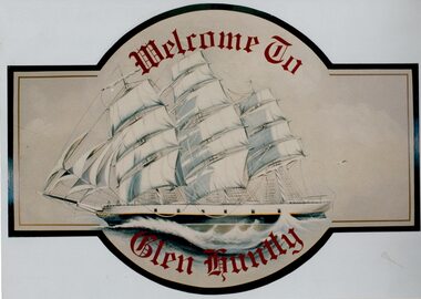
Article - GLEN HUNTLY (HISTORY OF)
This file contains 10 items about the history of Glen Huntly: 1/6 photocopied pages from ‘The History of St Kilda’ which relates to the place name Glen Huntly, and the Quarantine graves, date unknown. 2/2 photocopied pages from the ‘Sun Pictorial’ dated 13/4/1928 and 12/4/1928; relating to the state of the graves at Point Ormond and their re-internment to St Kilda Cemetery. 3/1 pen and ink sketch of graves at Point Ormond from the State Library Victoria. 4/3 pages taken from a website on the re-internment of graves and some social history as to the reason that the new emigrants were coming to Australia. The Article also has 7 photographs. 5/2 newspaper articles on the ‘Glen Huntly’ descendants forthcoming reunion being held on 21&22/4/1990. 6/1 article reprinted from newsletter no. 22 October 1983 on the barque ‘Glen Huntly’. Also details of passengers who died and the burial of 3 at Point Ormond. 7/1 handwritten document (unattributed) taken from ‘Migrant ships for South Australia 1836-1850’ by Ronald Parsons. 8/1 pamphlet commemorating the 150th anniversary of the ‘Glen Huntly’ arriving in Melbourne. It gives information about the ship, passengers, memorial in St Kilda Cemetery and upcoming descendants’ reunion. 9/1 program of commemoration events 21&22/4/1990. 10/1 piece of art work for a ‘Welcome to Glen Huntly’ sign, featuring a ship. Undated, unattributed and source unknown.‘glen huntly’, buchanan captain, fever ship, emigrants, cummins ann, st kilda cemetery, bowman mrs, caulfield, craig john, cameron miss, mcgonagle mrs, elsternwick, armstrong george, mathers james, the glen huntly pioneers memorial, jones alfred ramsey, st david’s uniting church (grange road), glen huntly, glen huntly road, lake street, glen huntly state school, glen huntly presbyterian church, south caulfield, mernda avenue, garden avenue, grange road, jenkin (boss) william, wattle avenue, chinese joss-house, smith a.w, glen huntly post office, foundation stones, king f.l, methodist church, trinity congregational church, greek orthodox church, salvation army temple, wanalta road, st anthony’s roman catholic church, st agnes’ anglican church, booran road, st david’s uniting church, el nido grove, manses, royal avenue, munster avenue, james street, rothschild street, neerim road, organs, peace memorial organ, railways, marara road, curraweena road, booran road, bambra road, rosstown railway, murray-ross william, leila road, murray-ross leila, ‘the grange’, north road, wild cherry road, ‘rosstown’, picture theatres, manchester grove, aerodrome, lord reserve, neville street, lyons street, morgan street, rosedale avenue, rifle clubs, glen huntly infant welfare centre, watson grove, rowlands drapery, drapers, bones plant nursery, nurseries, elsternwick railway station, railway stations, kooyong road, glen eira road, truganini road, rosstown sugar works, ross murray, street names, typhoid, diseases, death and dying -
Glen Eira Historical Society
Letter - HISTORIC BUILDINGS REGISTER
... . Church St. Georges Road Glenmoore Grimwade House Orrong Crescent ...This file contains 3 items: 1/A register of historic buildings in Caulfield dated 29/06/1978 2/A copy of the Historic Buildings Register from the Historic Buildings Council Victoria (current as at 22/10/1982. The copy has a business card attached with a handwritten note to ‘Dick/thought you might find this of use. Bernie’, from Bernard C. Carroll, the Senior Records Officer at Caulfield City Council. The accompanying letter is dated 17/01/1983 and stamped Caulfield Historical Society. 3/Two letters of correspondence to and from the Historic Buildings Council dated 26/10/1983 and 14/12/1983. It regards the application for Rippon Lea to be added to the Register of Historic Buildings.rippon lea, hotham street, elsternwick, caulfield, caulfield south, caulfield north, city of caulfield, caulfield city council, bernard c. carroll, bernie carroll, halstead street, halstead, poplar grove, athole, caulfield historical society, glenfern, inkerman street, craigellachie, orrong road, elsternwick club, sandham street, bambra road, balaclava road, glenferrie street, labassa, manor grove, lirrewa, lirrewa grove, lisbon house, myoora, alma road, hopetoun gardens, st. mary’s jubilee school, glen eira road, hood crescent, st. stephen’s presbyterian church, st. stephen’s pres. church, trinity congregational church, trinity congreg. church, grange road, bellecourt, seymour road, elsternwick congregational church, elst. congreg. church, st. georges road, glenmoore, grimwade house, orrong crescent, glenhuntly road, glen huntly road, state school no. 773, st. mary’s church of england, sandham street, selwyn street, former met. fire brigade station no. 31, presentation convent, o’neill college, nagle avenue, methodist church, neerim road, heatherbrae, elizabeth street, craddock avenue, rosecraddock, stables, tram shelter, city hall, civic establishments, local history, clubs and associations, historic buildings, registers, official buildings, local officials and employees -
Glen Eira Historical Society
Document - History of the City of Caulfield
... Leader Davies J. Henry Curraweena Road St. Georges Road O’Neill ...This file contains 4 items: 1/Typewritten document titled ‘The City of Caulfield’. Author and date unknown. 1 page (back and front), 2 copies. Document covers topics such as origins of the name ‘Caulfield’, early settlement and the Caulfield Cup. 2/Typewritten document titled ‘History of Caulfield Council’. Author and date unknown. 6 pages, 3 copies. Document covers subjects such as early settlement, Aboriginal influence, Caulfield Road Board, Shire of Caulfield, Borough and town boundaries, coat of arms, and Freedom of Entry to the City. 3/Typewritten document (undated + author unknown) titled ‘The Structure of Local Government in Victoria with a history of the City of Caulfield’. 13 pages. Covers the following subjects: Powers, Planning, Public Works, Trading Undertakings, Health Services, Municipalities, Wards Electors or Ratepayers, Voters Roll, Councillors, Officers, Finance, Nature of Soil and Vegetation, Parks and Gardens and Reserves, Coat of Arms, Boundaries, How Did Caulfield get its Name, Aboriginal Influence, Caulfield Road Board, Shire of Caulfield, Borough and Town and the City of Caulfield. Also covered is early settlement. Note at the end of the document mentions that the historical content contained in the last section was based upon a thesis for the Department of Town and Regional Planning, University of Melbourne, 1968 by L. Alwis, P. Rowe, N. Wootten. Melbourne, ‘City of Caulfield: An Illustrated City Report’. 4/Typewritten document (undated) titled ‘The Structure of Local Government in Victoria with notes on the history of the City of Caulfield’. 8 pages, 2 copies. This document also includes a map/diagram of the city with boundaries and wards showing locations of railway stations and parks. Document covers the structure of local government and its functions then goes on to focus on City of Caulfield with subjects similar to those covered in item 3. Document signed off by Deputy Town Clerk.city of caulfield, caulfield john, caulfield baron, caulfield racecourse, elsternwick, ripponlea, st. mary’s church, caulfield council, kooyong road, neerim road, bambra road, greenmeadows house, caulfield park, paddy’s swamp, dandenong road, caulfield grammar school, chisholm institute of technology, murrumbeena, glen eira road, alma road, orrong road, balaclava road, inkerman road, ‘grosmont’, caulfield school room, caulfield road board, caulfield road district, crimean war, victorian amateur turf club, caulfield cup, glenhuntly road, north road, glenhuntly station, ormond station, outer circle railway, local government, gardenvale, carnegie, rosstown, poath road, nepean highway, hotham street, ormond park, princes park, ross william murray, caulfield institute of technology, ‘ross’ folly’, hawthorn road, glenhuntly, ormond, morris t. w., lloyd charles du plan, meals on wheels, shire of caulfield, caulfield railway station, caulfield rsl, bouran road, murrum murrumbeen, kooyong road, great dandenong road, neerim road, trams, prahran and malvern tramways trust, fisher andrew, mackinnon reserve, dover street, ‘glen eira’, blair max cr., insignia, third ordnance services unit, schools, street lighting, lampriere, mr. bevan, the caulfield leader, davies j. henry, curraweena road, st. georges road, o’neill college, hope george, market gardens, koornang reserve, packer reserve, murrumbeena reserve, hopetoun gardens, greenmeadows gardens, mirambeena, caulfield technical college, hart john, langdon h. j., ‘rosecraddock’, judge webb, ‘crotonhurst’, service james, ‘kilwinning’, ricketson henry, grimwade frederick sheppard, airdrie, jenner, st. aubin’s, caulfield john p. t., harlston, lempriere, lord reserve, ‘cantala’ -
Glen Eira Historical Society
Document - National Trust Register
... Iknerman Road Sandham Street Selwyn Street St. Georges Road Willow ...This file contains two items relating to historic buildings in Glen Eira listed on the National Trust Registry: 1/A fax, sent to Gladys Vallati on 02/03/1995 from the National Trust of Australia listing buildings on the Trust’s registry in the Glen Eira area, as well as their addresses and status on the register (5 pages). (Additional photocopy taken for preservation purposes). 2/A typed list of buildings in the Glen Eira area (mainly Caulfield) which are on the National Trust list, including address, approximate date of construction and status on the register. Date of production of the list is unknown. (6 pages).neerim road, poplar grove, avoca grove, balaclava road, orrong road, bambra road, glen eira road, hood crescent, hawthorn road, glenferri street, glenhuntly road, glen huntly road, kambrook road, kooyong road, lirrewa grove, manor grove, north road, pearson avenue, seymour road, alma road, craddock avenue, dandenong road, lyndoch avenue, orrong crescent, hotham street, nagle avenue, inkerman street, iknerman road, sandham street, selwyn street, st. georges road, willow street, grange road, station place, railway parade, alexandra street, wood crescent, elizabeth street, halstead street, mavho street, tucker road, mckinnon road, nepean highway, wheatly road, uniting church carnegie, athole, st stephen's uniting church caulfield, st aloysius' catholic church, halstead, st mary's anglican church caulfield, caulfield town hall, anseln, the glen, woolamai, caulfield house, caulfield hospital, lirrewa, labassa, fairfield hall, bellecourt, bagatelle, myoora, rosecraddock, adam and eve - karl duldig, the family - karl duldig, caulfield primary school, septimus miller memorial chapel, brighton cemetery, hopetoun gardens, state savings bank elsternwick, anderson organ, hopetoun private hospital (melrose), rippon lea, ripponlea, burreel, o'neill college, lisbon house, elsternwick club, merkin-schutze organ, presentation convent, duldig mural - kadimah cultural centre, glenmoore, craigellachie, st james the great, glenfern, grimwade house, dacre, trinity congregational uniting church glenhuntly, alnwick, holmwood, new alexandra, joscelyne organ, smith organ, fincham organ, st george's bentleigh, mckinnon progress hall, wurlitzer organ, moorabbin town hall, christ anglican church, st mary's jubilee school, st stephen's presbyterian church, elsternwick congregational church, st mary's church of england, former metropolitan fire brigade station no. 31, st mary's jubilee church, belle court, trinity congregational church, heatherbrae, carnegie, caulfield, caulfield north, caulfield south, elsternwick, glen huntly, glenhuntly, murrumbeena, st kilda east, bentleigh, mckinnon, moorabbin, ormond, national trust of australia, national trust register, houses, churches, schools, organs, vallati gladys, mansions -
Glen Eira Historical Society
Document - National Trust Register
... Orrong Road Hotham Street Elsternwick St. Georges Road Houses ...This file contains two items about the activities of the National Trust of Australia: 1/The minutes of a Property Managers’ Meeting, held on 26/11/1996 at 11 AM at Mulberry Hill, Baxter. Of particular note in the minutes is a discussion of Labassa’s funds, and that new volunteers have been sent out to Rippon Lea (8 pages). 2/The programme of events conducted by the National Trust in April and June 1997, sent to Mr and Mrs. AJ Campbell, and containing a booking form. The programme includes several events held in Glen Eira, including at Labassa and Rippon Lea.national trust of australia, national trust register, labassa, rippon lea, ripponlea, glenmoore, manor grove, caulfield, orrong road, hotham street, elsternwick, st. georges road, houses, mansions, barnes lesley, hare joan, dobson lynette, campbell aj mr., campbell aj mrs., chesney lois, heathcote richard, white lorraine, bantow jennifer, granville fiona, montell lindy, cuoldy nola, simpson dorothy, campbell felicitie, heeley g. kevin, fabini margaret, pimm marjory, robinson heather, lear marie, slack ray, slack trish, robinson bruce, wilson pamela, thompson norma -
 Glen Eira Historical Society
Article - REGENT LODGE, REGENT STREET, 46, ELSTERNWICK
... Grammar School Glen Eira Road St. Georges Road Caulfield Uniting ...This file contains 10 items about the Regent Lodge Extension Appeal: 1/Three promotional pamphlets, all called ‘Regent Lodge: A special kind of care’, stating that a building appeal will be launched early next year. The pamphlets also list office bearers. 2/A letter from Rodney Horsfield, Chairperson of the Project Working group, to Betty Freeland of the Elsternwick-Caulfield South Parish, dated 25/03/1992, asking for her to consider becoming a member of the Appeal Team. The letter also contains information on the history of Regent Lodge, the plans for development and progress on raising funds to date. 3/A letter from Ian Clark, Chairman of the Regent Lodge Extension Appeal, to Betty Freeland, dated 18/05/1992, inviting her to the official launch of the Regent Lodge Extension Appeal at Caulfield Grammar School, 217 Glen Eira Road Caulfield on 31/05/1992. The letter gives brief details on the launch, saying it will be attended by the appeal’s patron, the Honourable Joan Child, AO, and the Playback Theatre company. 4/A letter, recipient and sender unknown, dated 26/05/1992, giving details of the appeal launch and a brief history of Regent Lodge. 5/Two newspaper articles from the Southern Cross, Caulfield, dated 16/06/1992. The first, ‘Grant boost for dementia sufferers’, discusses a federal government grant of $8 million to dementia services, and $9 million to disability services. Heathlands, Camden Court, Lovell House, Clarence Court, Regent Lodge and St. Kilda House all received funds. The second, ‘Lodge building appeal launched’, describes the Regent Lodge Extension Appeal and its launch, and includes brief comment by appeal patron Joan Child. The article describes the plans for the appeal and extension, and outlines how readers can make donations. Included is a black-and-white photograph of Joan Child with members of the Playback Theatre Group at the Appeal Launch. 6/The original of the photograph used in the newspaper article in item 5, showing Joan Child with members of the Playback Theatre Group at the launch of the Regent Lodge Extension Appeal. 7/A letter from Rod Horsfield, Convenor of the Project Working Group, to Betty Freeland, dated 22/06/1992, discussing the launch and asking for the opportunity to meet with her Parish council or Finance Committee. 8/The plans for the extension of Regent Lodge, as well as a colour drawing of what the front of the extension will look like. 9/Preliminary photographs taken for the appeal brochure ‘Regent Lodge: Committed to Caring’. Twelve black-and-white photographs of two elderly residents at tea. Also, one black-and-white photographs of an elderly resident being assisted by another person, likely a staff member. 10/Three copies of the appeal brochure ‘Regent Lodge: Committed to Caring’. The brochure contains information about the lodge, the plans for the development, including a floorplan for a typical six bedroom unit, the costs of the extension and breakdown of how the appeal target amount would be spent, and messages from patron Joan Child, Appeal Committee Chairman Ian Clark, and Convenor of the Project Working Group Reverend Rod Horsfield. Also included is a list of the members of the Appeal Committee and Project Working Group. Black-and-white photographs of residents and workers at the Lodge are included in the brochure.regent lodge, regent street, elsternwick, emma street, caulfield south, heathlands, camden court, lovell house, st. kilda house, balaclava, caulfield grammar school, glen eira road, st. georges road, caulfield, uniting church, uniting church lodge program, regent lodge alzeimer appeal, regent lodge extension appeal, tansley hunt and partners, nepean presbytery, child joan the honourable, horsefield rod rev., horsfield rod rev., horsfield rodney rev., lukies noela mrs., campbell jack, cardell bob, davies gail mrs., greensmith duncan, tansley vern, merrick ruth ms., seccull barbara ms., freeland betty miss, clark ian, wilcox rosemary mrs., coleman julie, playback theatre company, martens veronica mayor, brown george, terrell tom, diseases, disabled people, nursing homes, fundraising events, aged people -
Glen Eira Historical Society
Ephemera - Rotary Club of Elsternwick
... of Elsternwick St. Georges Road Murphy Chris Fitzgerald Gerry Meehan John ...This file contains two items relating to the Rotary Club of Elsternwick: 1/Changeover dinner program held 02/07/1998 for incoming president. 2/Pamphlet for the first Annual Wine and Food Expo held 15/07/1998.rotary club of elsternwick, st. georges road, murphy chris, fitzgerald gerry, meehan john, bird jeffrey, sanicki claude, harris. christine, anderson sandy, jackson adrian, reidy brendan, waratah cellars, glenhuntly road, mailboxes etc, clubs and associations, events and activities, eating and drinking, festivals and celebrations, shows and exhibitions, elsternwick station -
Glen Eira Historical Society
Document - TOURS
... ’ Regent Street St. George’s Road Cottages Bent Thomas Sir. Jones ...There are two copies of the Discover Caulfield guide produced by the Caulfield Historical Society. One from 1982 which contains twelve pages, seven of which are typed and the last five a continuation of the guide added later, hand-written. The other is a modern typed version of the same document. They both detail a pictorial tour of the mansions and gardens in the City of Caulfieldcaulfield, mansions, gardens, homes, ‘lirrewa’, lirrewa grove, caulfield city hall, smith sydney, ‘halstead’, bambra road, halstead road, caulfield historical society, messrs. upton and smith, civic establishments, dickson james dr., houses, national trust, st. stephen’s church, balaclava road, gothic (revival) architecture, messrs. haddon and henderson, st. aloysius, archbishop of melbourne mannix dr., caulfield park, hawthorn road, inkerman road, kambrook road, paddy’s swamp, cannizzo philip, caulfield city council, trams, orrong road, grimwade house, ‘harleston’, grimwade frederick sheppard, primary schools, caulfield art centre, ‘stanmark’, art galleries, ‘craigellachie’, person william, pearson eliza, francis newton mr., greenmeadows gardens, milburn grove, greenmeadows house, lempriere john, mayors, ‘glenfern’, boyd john captain, boyd martin, ‘myoora’, alma road, ‘bagatelle’, christian thomas, henderson anketell, flats, building construction, ‘burreel’, kooyong road, burreel avenue, francis john, stephen sidney, allan george l., ‘royston’, renwick s. mrs., sargood frederick sir., ‘glen eira’, ricketson henry, caulfield hospital, royal southern memorial hospital, caulfield general medical centre, ‘ripponlea’, reed and barnes, architects, towers, rippon emma, rippon thomas, guilfoyle william, employees, ‘the village houses’, regent street, st. george’s road, cottages, bent thomas sir., jones louisa mrs., nathan benjamin, ‘anselm’, glenferrie street, queen anne style, haddon robert, historical buildings, princes’ park, ‘glenmore’, watts thomas, more hugh, glenhuntly road, gates, villas, ‘hopetoun’, hopetoun street, webb charles, hopetoun hospital, harleston park, allison street, langdon montague, langdon harry joseph, ‘tarqua’, ‘labassa’, manor grove, koch john, robertson a. w., wagner john, ‘ontario’, trinity congregational church, grange road, glen huntly, churches, greek orthodox church, ‘fairfield hall’, north road, younger james, glenhuntly post office, smith alfred, smith anne, methodist church, ‘lambros the cobbler’, railways, ballantyne r., snowball betty, kahlyn private hospital, ‘kynaston’, st. mary’s jubilee school, festivals and celebrations, st. mary’s anglican church, church of england, bishop moorhouse, joynt donoman, elsternwick post office, elsternwick, elsternwick bowling club, elsternwick rsl, caulfield grammar school, davis henry rev., selwyn street, elsternwick railway station, glen eira road, barnett r. j. rev., tudor court, world war 1914-1918, ‘fairhaven’, hope george, caulfield library, plaques, cannons, ‘janvec joinery’, parkside street, ‘parkside court’, clarence street, ‘streetscene’, grange road, greenhouses, vallati gladys -
Glen Eira Historical Society
Article - MCKINNON
Brief typed history of McKinnon settlement taken from Moorabbin A Pictorial History 1862-1994 by John Cribben. Includes photocopied pages of railway gates, five land estate flyers and an article from the McKinnon Progress, undated.mckinnon, cribben john, crop production, markets, farmers, elster creek, mcmillan archibald, thomas street, centre road, wheatley road, vineyards, south road, ormond, brighton, moorabbin, irish, immigrants, bentleigh, priests, hanrahan pierce, hanrahan johanna, caroll michael, caroll catherine, howes eliza, howes john, howes edward, shanahan denis, shanahan ellen, gould james, gould catherine, howes george, bignell road, jasper road, tucker road, mcguiness family, quinn family, halinan family, malane family, inns, the gardeners arms, mckinnon hotel, bent james, bent thomas, tickets of leave, murray road, were nicholas, sargood family, ripponlea, mansions, elsternwick, st. stephens’ common school, church of england, school houses, evelyn street, st. john’s anglican church, telegraph offices, post offices, state schools, manchester road, north road, nicholls buildings, rivers frank, rivers ray, shops, pridgeon mr., elm grove, sobrin mr., clark misses, greaves bakery, armitage mrs., rout mr., tunnicliffe mrs., lance’s milk bar, johnson’s hardware shop, stiringer mrs., white horrie, robinson’s, mcinnerney’s flower shop, jean darling’s cakes, wyles jim, mckinnon progress association, glen orme avenue, ormond theatre, theatres, lester harry, the plaza, railway crossing, railway gates, wright street, nichols l., builders, pine grove, halls, st. elmo estate, patterson station estate, patterson road, brewer road, purton road, clee hill estate, railway park, hawthorn grove, wattle grove, elm grove, learys estate, manchester road, selkirk avenue, masters estate, lancaster street, moylan street, moorabbin railway crossing -
 Glen Eira Historical Society
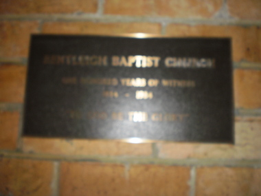
Document - Bentleigh Baptist Church Vickery Street Bentleigh
Reflections reprinted history extracts from Bentleigh Baptist Church Diary from September 1989 to March 1993. Issues includes a CD with digital photos Reflections reprinted history upon the centenary of Bentleigh Baptist Church 1984 by DL Audemard from May 1985 The Way We Were Feb 1990 pamphlet notes reflections on the churches ministery over the last 50 years by unknown author A brief printed history author unknown and undated on Bentleigh Baptist Church, 10 Vickery Street Bentleigh Two computer generated articles of correspondence between Claire Barton and Robert Bell on the gathering of Bentleigh & Korean Baptist Church history April 2010bentleigh, baptist church, brewer mr, tucker road, box henry, lush gp rev, east boundary, north road, bentleigh baptist church, brighton baptist church, tucker road church, box francis, box edith, clay jack, clay joy, lipman vern, lipman bronwyn, watt family, pioneers, watt richard, watt martha, market gardens, centre road, jasper road, watt herbert, horse drawn vehicles, stamp mr, hall annie, vickery street, watt may, clay family, marriott hector, watt don, watt family, box chris, lipman joy, grewar family, alexander chas, shephard f, chapman samuel rev, chambers h, eunson ta rev, boreham e rev, fletcher w rev, marriott hec – market gardens, kennedy jack, kennedy lil, kennedy isa mary, herron john, seawright celia, streckfuss edith, cole alice, grewar annie, grewar hall, faulkner ern, graham tom, cross mabel, cross w rev, trenches, grewar jean, ormond, wadley mr, wellum mr, hinton wh, rees gp rev, hinton mrs, wade ken rev, wadley mrs, bent st, wade mrs, bell powell, warner lawrence, architects, winckel l rev, richards jl, builders, streckfuss bert, marriott may, streckfuss family, sach florrie, sach family, reid mrs, reid lesley, mcmillan mrs, drapers, mckinnon road, streckfuss edith, simpson mrs, wellum mrs, leadlights, main mary, evans william john, cooke j, cooke mrs, cahill samuel george, smith kate, freeman nancy, wanless mrs, redmore ab, redmore mrs, audemard phil rev, hawkins margaret, ord elton, hawkins shiela, pith ron, bell mr, wallace pat, bell margaret, audemard joan, docker sandra, hubbard mark, thomas bernie, thomas mrs, lamprell mrs, herron mr, herron mrs, freeman mrs, beach mrs, paton john mrs, george lloyd, aspinal eric, bell gwen, sutton mrs, winkel mrs, neil mary, costain mrs, main mrs, baker mrs, cross mrs, kershaw mrs, smith millie, smith jack, freeman alf, harwood lindsay, harwood doreen, bell lesley, bell roberta, bentleigh korean baptist church, barton claire, hoare mike, hoare margaret, bott muriel, bridgeman pat, cook don, small hugh, trewin bill, smith eddie, iggulden sid, neve keith, horsford david, spencer wally, mcewan bill, holmes ron, holmes joyce, pullman peter, pullman elly, probbel peter, robinson john, bott laurie, main alice, disney clarrie, taylor kath, woff miss, rutledge peter, cameo playgroup, bentleigh baptist church, bentleigh, tucker road, foundation stones -
Glen Eira Historical Society
Document - BIRDS
... Elsternwick Elsternwick St Georges Road 1 Rippon Lea Bird Migration ...This file contains a BIRD CENSUS taken on 01/01/1997, author unrecorded. The census lists the number and breed of several species of birds observed in the author’s garden, giving a description of the birds and the frequency of their visits to the area. The census also includes the address of the author and the time of day the survey was completed.animals, birds, ornithology, greenies, gumtrees, trees, fruit-bats, wildlife, elsternwick, elsternwick st georges road 1, rippon lea, bird migration, nesting habits, bird census, surveys, statistics -
Glen Eira Historical Society
Document - LEMPRIERE AVENUE
1/A newspaper cutting from The Argus 12/07/1927 (a print-out of same from Trove), praising the virtues of demolishing former mansion ‘Rozelle’ and erecting a ‘score’ of pretty modern villas from Balaclava Road directly into Green Meadows Gardens, a public reserve. Article describes modernity of homes in great details and the streetscape vistas (1 photo included) including road and pathways. 2/A Caulfield St Kilda Leader, dated 25/08/1993, article with Caulfield residents George and Edna McKaige wanting a planning amendment ‘with teeth’ to protect their Lempriere Ave streetscape. Andrew Ward, Heritage Architect, identified Lempriere Ave as one of Caulfield’s significant areas, because of its Interwar streetscape.east st kilda, ‘rozelle’ mansions, balaclava, land subdivision, balaclava road, georgian style, spanish mission style, orrong road, greenmeadows gardens, lempriere avenue, leadlight, mckaige george, power and telegraph lines, triple-fronted style, interwar streetscape, mckaige edna, ward andrew, caulfield council, elsternwick, welsh heather (councillor), councillors, akehurst jeff, caulfield heritage watch, spencer david, johnson john dr., ‘kilwinning’, george h., peterson william mrs., ‘melby’, ‘springfield’, rose-watt miss, ‘rozelle’, ‘cressy house’, meadow street, smith wallace m., heron herbert l., ‘goathland’, ‘melbe’, wright james, marsh malcolm reginald, house names, melby avenue, springfield avenue, goathlands street, kilwinning court, heritage studies, town planning -
Glen Eira Historical Society
Letter - CAULFIELD YOUTH COUNCIL
... A St. Georges Road Elsternwick Higgins Shipton Roger Spencer ...This file contains six items: 1/A copy of the Caulfield Youth Council Statement of Purposes. 2/Correspondence dated 07/10/1981 regarding the Community Youth Support Scheme and levels of funds received for 1982. 3/Two financial statements for the Caulfield Youth Council. One dates from 01/03/1984 – 18/04/1985 and the second dates from 01/07/1986 – 30/06/1987. Contains handwritten annotations and signature of L.Goodfellow, dated 18/04/1985. 4/Three Caulfield Youth Council Meeting minutes from the period 04/10/1984 to 18/04/1985. 5/A copy of Caulfield Youth Council’s 1987 A.G.M Agenda which includes the 1986 A.G.M minutes and the Youth Development Officer’s Report. Contains handwritten annotations, author unknown. 6/Miscellaneous information that perhaps would have been provided and discussed at a Caulfield Youth Council meeting, date and sources unknown. One is the constitution for the Southern Region Youth Action Council and the other is an Appendix to the White Paper on unemployment.caulfield youth council, caulfield festival, caulfield city caulfield, goodfellow l., neale ray, caulfield, brain ian, c.y.c, carr kate, caulfield high school, nevinson wayne, howard kerry, musgrove wendy, bowman jenny, welham roberta, schaeffer rema, ferdinands ken, bigeni anne, carr mandy, carr steven, ecimovic mitch, larson john, campbell jack, o’neill wells, hanevski gena, diamond jack, marek waldemar, smith vicky, carr stephen, jacobs david, williamson dave, williamson david, caulfield south, gunther lisa, farmer reg, feder stephen, cook damien, atteins ben, caulfield youth council incorporated, caulfield town hall staff house, farmer reggie, carr manda, carr kate, noulton peter, schaffer renna, feden stephen, kershaw tracey, musgrave wendy, jackson clive, loursen john, enright danny, doman pam, sheehan tony, st. kilda east, campbell fiona, mcinerney john, mardling matthew, shaffer rena, henevski gina, shawki enas, melvin david, tanner ted, maple street, smith wendy, goodfellow loris, scheaffer rema, atkins ben, gibbs brett, miller nicki, nugent virginia, lechmus julian, caulfield park, clay liz, campbell a, st. georges road, elsternwick, higgins, shipton roger, spencer david, cox lisa, ellmer kay, enion paul, ashton kim, toulidakis george, wilkin john, conway shaun, tesoriero dominic, beaumont kim, skinner simon, mcquarrie kay, wiseman anthony, garland nigel, merifield rod, ashton matthew, schaffer rema, leclerc lorraine, loorham warren, tanner ted mr, nye lyn, ellmer ray, youth of caulfield, ellmer kerry, campbell j, seidel bernie, caulfield lions, caulfield lions club, glenhuntly, caulfield council, matzirodoz arti, kids in caulfield, k.i.c, nisbet karen, the lions club, smith loretta, leitch meaghan, sallis richard, city of caulfield, caulfield city council, young adults, youth clubs, youth, community services, meetings, civic establishments, community organisations, local government, local officials and employees, mayors, financial documents, teenagers -
Glen Eira Historical Society
Document - McKinnon
Brief typed history of McKinnon settlement taken from Moorabbin A Pictorial History 1862-1994 by John Cribben. Includes photocopied pages of railway gates, five land estate flyers and an article from the McKinnon Progress, undated.mckinnon, crop production, markets, farmers, elster creek, thomas street, centre road, wheatley road, vineyards, south road, ormond, brighton, moorabbin, irish, immigrants, bentleigh, priests, bignell road, jasper road, tucker road, mcguiness family, quinn family, halinan family, malane family, inns, the gardeners arms, mckinnon hotel, tickets of leave, murray road, sargood family, ripponlea, mansions, elsternwick, st. stephens’ common school, church of england, school houses, evelyn street, st. john’s anglican church, telegraph offices, post offices, state schools, manchester road, north road, nicholls buildings, shops, elm grove, greaves bakery, lance’s milk bar, johnson’s hardware shop, robinson’s, mcinnerney’s flower shop, jean darling’s cakes, mckinnon progress association, glen orme avenue, ormond theatre, theatres, the plaza, railway crossing, railway gates, wright street, builders, pine grove, halls, st. elmo estate, patterson station estate, patterson road, brewer road, purton road, clee hill estate, railway park, hawthorn grove, wattle grove, elm grove, learys estate, manchester road, selkirk avenue, masters estate, lancaster street, moylan street, moorabbin railway crossing, archibald mcmillan, john cribben, pierce hanrahan, johanna hanrahan, michael caroll, catherine carroll, eliza howes, john howes, edward howes, denis shanahan, ellen shanahan, james gould, catherine gould, george howes, james bent, thomas bent, nicholas were, frank rivers, ray rivers, mr sobrin, mr pridgeon, misses clark, mrs armitage, mr rout, mrs tunnicliffe, mrs stiringer, horrie white, jim wyles, harry lester, l nichols -
Glen Eira Historical Society
Elsternwick
... Estate Agents Classic Cinema Theatres St. George’s Road Elizabeth ...This file contains three items., Photocopied and three page retyped article, undated c.1930s and source unknown from Real Estate Agent Philippe Batters 03/09/1997., Three page document from Keith James Smith, undated, on research on Elsternwick and Glen Huntly Road shops and traders., Three articles from THE AGE 13/05/2000 and 15-16/02/2013 and MELB BAYSIDE WEEKLY 03/11/2010 giving snap shots of Elsternwick housing and facts.batters philippe, real estate agents, elsternwick, paddocks, glen huntly road, watler, kelly, elsternwick park, slaughter yards, glen eira roads, point ormond, glenhuntly railway station, nepean highway, grange road, holdsworth’s jewellers, staniland grove, coles store, shops, orrong road, fosseys, hattams mensware, woolworths, dalgarnos crockery and kitchenware, chapmans gifts, garth’s shoe store, garth, jack, allen’s furniture and auction rooms, elsternwick market, adam’s cakes, mr. green’s pet shop, turner, mr., grocer shop, moores lendring library, hopetown gardens, gardens, jack hatheralls butchershop, butchers, chinese laundry, chinese community, laundries, mr. & mrs. darbyshires milkbar, st. johns church, kooyong road, hasseles garage, garages, royal parade, glenhuntly, camden, hawthorn road, blacksmiths, camden town, dolls hospital, caulfield state school 773, independent picture, theatres, camden theatre, southern indoor bowl centre, larch street, montessorie school, collins milk bar, milk bars, collins, lin, hartrick, miss, armond, mr., lennie, mr., rothells sausage factory, north road, red bus service transport, furlonger, miss, dance studio, moran and cato grocery, cato family, newsagent, tozer, brook, furniture store, green gables, american style soda fountain and milk bar, hoyts renown theatre, state savings bank, riddell parade, clarence street, aileen avenue, smith, keith james, camden town, sports club, peer, gary, gary peer & associates, brukarz, jack, ray white real estate, real estate agents, classic cinema theatres, st. george’s road, elizabeth street, allison road, gladstone park, myrtle street, victoria street, caulfield, st kilda east, lisbon house, orrong road, house names, rippon lea estate, caulfield south, carnegie, gordon street, carre street, main street, clarence street, elsternwick club, jewish holocaust museum, daily planet, brothels, wesley college, elsternwick primary, st. joseph’s primary, scholem aleichen college, liebler yavneh, hopetoun gardens, harleston park -
Glen Eira Historical Society
Article - Stephen Family
... Shoobra Stephen Sir George Caulfield St. Mary’s Church Helenslea ...This file has five items. Printed family tree from 1733 to 1856. Printed family tree from 1770 to 1939. Hand drawn family tree specific section from Mennell page 434. Four pages of handwritten notes from rate books, and a small amount of family research included as well. Newspaper article from The Age, 17/02/1973, mentioning author Virginia Woolt relation to James Stephen family tree. Handwritten notes from RHSV pioneer register. Handwritten notes on the Stephen family. Photocopy of entry on J.W. Stephen from Australian Dictionary of Biography 1851 – 1890.stephen james wilberforce., stephen mary anne sibella., stephen hart mary, stephen hart john, stephen hart susannah., stephen hart henrietta, stephen hart katherine., stephen hart thomas, stephen hart george, stephen hart edith, avoca grove, stephen george, orrong road, glen eira road, east st. kilda, mansion, whittingham geo, stephen anne atkinson., stephen james, stephen george milner elmslic., kooyong road, glen huntly road, glenhuntly road, gladstone parade, camden town, stephen francis john sydney., bureel, buxton mrs, shoobra, stephen sir george, caulfield, st. mary’s church, helenslea, riddell mrs, stephen william ravenscroft. -
Glen Eira Historical Society
Document - St. Georges Road, 53, Elsternwick
... . Period of residencies covered: 1911 to 1948. St. Georges Road ...Two itemsabout this property: 1/Melbourne Weekly Bayside dated 19/10/2011 newspaper advertisement on forthcoming sale of property; includes brief details and five colour photographs of interior and exterior. 2/Hand written details from Sands and McDougalls, researched by Claire Barton, 01/03/2013. Period of residencies covered: 1911 to 1948.st. georges road, elsternwick, edwardian style, bay windows, lasslett emma, siddall jas. w, hotham grove, williams miss r.e, beaver miss b.e, biggin and scott, architectural features -
Glen Eira Historical Society
Document - St. Georges Road, 48 Elsternwick
... Jas. Henderson Miss A. Leach Chas H. Document St. Georges Road ...This file contains two items. Newspaper article from MELBOURNE WEEKLY BAYSIDE 26/07/2008 including three coloured photographs. Article mentions period features and updated renovations. Research by Claire Barton dated 01/03/2013 on occupiers of number 48 from 1903 to 1948. Taken from SANDS AND MCDOUGALLS.st. george’s road, elsternwick, edwardian, bay windows, plaster moulds, stained glass, biggin and scott, elsternwick tennis club, henderson jas., henderson miss a., leach chas h. -
Glen Eira Historical Society
Document - St. Georges Road, 65, Elsternwick
... occupiers 1911-1948. St. Georges Road Elsternwick Federation Lead ...1/One newspaper advertisement, dated 30/05/2012, which includes four coloured photographs. Ad mentions house features and renovation extras. 2/Hand-written research by Claire Barton from Sands and McDougall Directories of former occupiers 1911-1948.st. georges road, elsternwick, federation, lead lights, bay windows, verandas, champion fredk, vaughan cath mrs, cleverly desmond e. -
Glen Eira Historical Society
Document - St. Georges Road, 69, Elsternwick
... and McDougall Directories. St. Georges Road Elsternwick Federation Style ...This file contains three items about this property: 1/Newspaper advertisement for property sale including three colour photographs, dated 05/10/2002 likely from the Leader newspaper. Gives brief house history and period features retained plus renovated details. 2/Auction flyer hand dated 2002 for auction 27 October. 3/Hand-written research by Claire Barton dated 05/03/2013 on occupiers of property taken from Sands and McDougall Directories.st. georges road, elsternwick, federation style, bay windows, plaster moulds, lead lights, verandas, evans mrs. m.a., hart mrs. m.s., dickson rnld s., wright-smith j.c., montgomerie norman l., shanghai, parks samual, bullock fredk t., house names, higgins thos w, marshman fredk, marshman e m miss, buxton real estate, architectural features -
Glen Eira Historical Society
Document - St. Georges Road, 76, Elsternwick
... on property occupiers 1903-1948. St. Georges Road Elsternwick Dumas ...This file contains two items about this property: 1/Newspaper advertisement on forthcoming sale of property, dated 14/07/2000. Includes coloured photograph. 2/Hand-written research by Claire Barton from Sands and McDougall Directories on property occupiers 1903-1948.st. georges road, elsternwick, dumas geo a., scott arth h., architectural features, liscard street, glen eira road, criswick harold e. -
Glen Eira Historical Society
Book - Thomas, George
History and biography of George Thomas senior and junior. Also gives details of the siblings, family tree of few siblings, and some plans of Thomas properties. A forty-four page book published by Eric F. Thomas in 1986thomas eric f., thomas george, thomas george snr, thomas george jnr, land surveyors, land subdivision settlements, estate of klaterville, brighton estate, churches, church groups, mckinnon road, thomas road, thomas street, tucker road, orrong road, glen eira road, st marys church of england glen eira road, gardeners, farmers, caulfield, seymour road, thomas george alfred, thomas adelaide, warrein road, north road, thomas percival theodore, thomas elsie adelaide, thomas arthur gilbert, quarries, stone quarries, agricultural activities, methodist church, church groups, thomas cecilia hilda, thomas stanley charles, thomas bertha alice, melbourne street, murrumbeena, murrumbeena methodist church, sunday schools, sunday schools teacher, moonya road, thomas amy ida mary, women’s christian temperance union, thomas edith minnie, bible society, thomas william henry, linacre jane ann