Showing 922 items matching "stone building"
-
 Sunbury Family History and Heritage Society Inc.
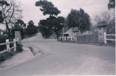
Photograph, Rosa McCall, Old Broadmeadows Township, 1949
The small town in the photograph is the former Broadmeadows Township (now part of Westmeadows). It was situated on the Old Sydney Road (Mickleham Road) and 2 miles east of the Broadmeadows Station. The stone bridge in the foreground spans the Moonee Ponds Creek and Fawkner Street is the road, which leads southwards to Gladstone Park and Tullamarine. The little building was a lolly shop that Mrs. Ethel Mitchell owned and ran for many years.Until 1869, before Sydney Road was finally opened, travellers on their way to Sydney would pass through the Broadmeadows Township.A copy of a non-digital black and white photograph of a road way with a bridge in the foreground leading to a small settlement. Small building with a pitched roof and a verandah is on the RHS of the image and the road leading out of the town is bordered with an avenue of pine trees.old broadmeadows township, fawkner street, moonee ponds creek, westmeadows, bridges -
 Ballarat Heritage Services
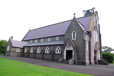
Photograph - Digital photographs, L.J. Gervasoni, Infant Jesus Catholic Church Koroit, 2011-2016
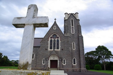
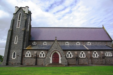
http://vhd.heritagecouncil.vic.gov.au/places/69285 " ... the foundation-stone of the new church at Koroit was laid by Bishop Goold on New Year's Day, 1867. It was said of Fr. Parle that his one. fault was "extravagant ideas of church building," and to his vision must be attributed what was called at the time "the most magnificent and costly ecclesiastical building in the Western District." Altogether about £6000 was spent on the Koroit church, a large sum in those days. It entailed much delay while the money was being collected, and Fr. Parle did not live to see the completion of the great work he had undertaken. .. " (The Advocate, 13 August 1947.) Digital images of a funeral congregation at Infant Jesus Catholic Church in Koroit, Victoria. church, catholic, koroit, infant jesus, exterior, presbytery, bluestone -
 Ballarat Heritage Services
Photograph - Photograph - Colour, L.J. Gervasoni, Koroit's Infant Jesus Church, 2011, 20/03/2010
" ... the foundation-stone of the new church at Koroit was laid by Bishop Goold on New Year's Day, 1867. It was said of Fr. Parle that his one. fault was "extravagant ideas of church building," and to his vision must be attributed what was called at the time "the most magnificent and costly ecclesiastical building in the Western District." Altogether about £6000 was spent on the Koroit church, a large sum in those days. It entailed much delay while the money was being collected, and Fr. Parle did not live to see the completion of the great work he had undertaken. .. " (The Advocate, 13 August 1947.)Colour photography of a bluestone church known as Infant Jesus and presbytery. koroit, catholic church, infant jesus catholic church, presbytery -
 Chelsea & District Historical Society Inc
Photograph - Chelsea Bush Nursing Hospital, c 1940
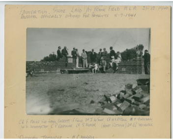
Chelsea Bush Hospital was well known as a maternity hospital and many local residents were born there or attended as children. The foundation stone of the hospital was laid on 21 December 1940 and was officially opened for patients on 5 July 1941. Later the building was used as a nursing home. The building has been demolishedBlack and white photos of officials and guests laying the foundation stone for Chelsea Bush Nursing Hospital. Handwritten on the mounting: Foundation Stone Laid by Frank Field MLA 21-12-1940 Hospital officially opened for patients 5-7-1941 Cr. E. F. Meier, Sir James Barrett, Dr J Le Souef, Cr H. S. McColl, H. J Stracham, W. J. Dennington, C. P. Gartside, Cr S Black (front sitting), Dr G. Geigall. Successful tenderer - N. C. Harrischelsea bush hospital, chelsea, medical -
 Chelsea & District Historical Society Inc
Photograph - Chelsea Bush Nursing Home, c 1942
Chelsea Bush Hospital was well known as a maternity hospital and many local residents were born there or attended as children. The foundation stone of the hospital was laid on 21 December 1940 and was officially opened for patients on 5 July 1941. Later the building was used as a nursing home. The building has been demolishedTwo black and white photos of Chelsea Hospital, Station Street, ChelseaDistrict Hospital, Chelsea City of Chelsea Hospitalchelsea bush hospital, chelsea, medical -
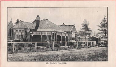 Sunbury Family History and Heritage Society Inc.
Photograph, ST. MARY'S VICARAGE, c1920
The Federation style house was the former vicarage for St. Mary's Church in O' Shanassy Street, Sunbury. It replaced the former 'Priorswood' vicarage, which was in Station Street about a mile from the church. The foundation stone for the new vicarage was laid by Mrs. Russell Clarke on 21st February 1914 and was opened by His Grace the Archbishop of Melbourne on 10th June 1914. A non-digital black and white photograph with a cream border across the top and base of the image off a brick federation style home with a corrugated iron roof. It has a return verandah with a decorative wooden trip under the eaves. A car is parked in the street by the gate and there are two buildings behind the house.st. mary's church of england, sunbury, vicarages, o'shanassy street -
 Eltham District Historical Society Inc
Folder, Eltham Obelisk (later Cenotaph), 1918-2018
The Eltham Obelisk was originally located at the corner of Bridge and Main Roads in 1919. In 1943 (WW2) the local community commenced plans to establish the Eltham War Memorial, a living memorial to benefit the children as opposed to a one in stone as per the obelisk. The Eltham War Memorial Trust was established in 1945. In 1947 the Trust intended for the Obelisk to be relocated from Bridge Street and Main Road to the Garden of Remembrance which was planned as part of the Baby Health Centre which was to be the first of three buildings of the Eltham War Memorial to be built in 1951. In 1951 the Eltham RSL was invited to be represented on the Eltham War Memorial Trust. Around this time, with pending roadworks, the obelisk was relocated to the front garden of the Eltham RSL sub branch on Main Road for safe keeping. In 2007, a suggestion was proposed by Harry Gilham (President, EDHS) to John Cohen (ERSL) to claim a special site along with the historic Shillinglaw trees on the now vacant former Eltham Shire Office site adjacent to the Eltham War Memorial precinct for relocation of the obelisk. In 2010 following the financial collapse and sale of the Eltham RSL Sub-Branch property and amalgamation with the Montmorency Eltham RSL sub-branch, the location of the obelisk was again in immediate jepoardy and in conjunction with Nillumbik Shire Council, the obelisk was relocated in front of the Eltham War Memorial buildings in preparation for the Dawn Service on Anzac Day 2012. Contents: Newspaper article: Eltham Obelisk of 1919, Harry Gilham, August 2000 as well as draft submitted dated 22 Aug 2000 Newspaper article: Eltham, The Advertiser 15 Nov 1918 and 18 Nov 1918 Newspaper article: An Obelisk at Eltham, The Advertiser, 11 Jul 1919 Newspaper advertisement: Unveiling of Obelisk at Eltham, The Advertiser, 1 Aug 1919 Newspaper article: Eltham Soldiers’ Memorial; Unveiled by Sir William Irvine, The Argus, Monday, 4 Aug 1919, p8 Newspaper article: Eltham Memorial to Fallen Soldiers, Diamond Creek Valley Advocate, 8 Aug 1919 Newspaper article: Memorial to the Fallen; Unveiled at Eltham, The Age, Monday, 4th August 1919 Newspaper article: Programme - Presentation of German Machine Gun at the Obelisk, Eltham on Sunday, 8th August, 1920, at 3.30 P.M. Newspaper article: article about presentation of a war trophy, a heavy machine gun placed beside obelisk, The Advertiser, 13 Aug 1920 Newspaper article: Eltham: ANZAC Services, The Advertiser, Friday, May 2, 1924 Newspaper article: Eltham War Memorial, The Advertiser, Oct 26, 1928 Handwritten note from Harry Gilham (President EDHS) to John Cohen (ERSL) regarding history of Eltham RSL site and 1947 newspaper article "Eltham War Memorial Trust "Garden of Remembrance" referencing relocation of Obelisk to the proposed Garden of Remembrance at the Baby Health Centre (Eltham War Memorial). Officers' reports, 11.113/10 Relocation of Eltham RSL Cenotaph, Nillumbik Shire Council Ordinary Meeting, 21 December 2010 Email Correspondence: EDHS President to NSC General Manager Community and Leisure re RSL Obelisk (Cenotaph) proposed relocation, 24 May 2011 Newsletter Extract: Eltham RSL and War Memorial, EDHS Newsletter 14 Sep 2011 Officers' reports, OCM.091/11 Interim Relocation site for the Eltham Cenotaph, Nillumbik Shire Council Ordinary Meeting, 23 August 2011 Officers' reports, OCM.004/121 Interim Relocation of the Eltham Cenotaph, Nillumbik Shire Council Ordinary Meeting, 31 January 2012 (includes Funding agreement between NSC and Montmorency-Eltham RSL Sub-branch Inc) Newspaper article: Move war memorial: RSL, c.2011 Newspaper article: Memorial move lags, Diamond Valley Leader, 1 February 2012 Newspaper article: New dawn for tribute, Diamond Valley Leader ca April 2012 Open letter to the residents of Eltham and Montmorency and copies of drafts by the Montmorency Eltham RSL, no date and final version published in Diamond Valley New 21 March 2012 and Banyule & Nillumbik Weekly, 27 March, 2012 Newspaper article: RSL site nets $1.8m, Diamond Valley Leader, 9 May 2012 Newspaper article: Memorial Moved, Banyule/Nillumbik Weekly, 10 April 2012 Newspaper article: Eltham cenotaph move goes 'like clockwork', Diamond Valley Leader, 11 April 2012 Advertisement, Program for Eltham Dawn Service, Diamond Valley Leader, April 2012 Newspaper photo: Veterans (l-r) Alan Field, Max Lowerson and John Cohen will join piper David Cretney to commemorate fallen Diggers, 2012 (standing beside relocated obelisk in front of the Eltham War Memorial complex) Program for Montmorency Anzac Day March 2012 (incomplete, some pages duplicated, some pages upside down). Newspaper article: Plan to expand memorial, Diamond Valley Leader, Sep. 2004, p5 Newspaper article: Names renewal, thanks to Barry, Diamond Valley Leader, 18 Apr 2007, p3 with picture featuring Eltham RSL president John Haines and Gwen Rosewall Letter: EDHS President to Manager Community Participation, Learning and Culture, Nillumbik Shire Council regarding a proposal by the Montmorency-Eltham RSL Sub-branch to expand the area occupied by the relocated obelisk further into the Eltham War Memorial Garden of Remembrance, 18 Aug 2014 Notices of Motion, NOM.001/14 pertaining to memorials Advisory Committee and Montmorency-Eltham RSL to upgrade the Eltham War Memorial site in time for ANZAC Day 2015, Nillumbik Shire Council Ordinary Meeting, 26 August 2014 Agenda: User Groups and Stakeholders Meeting, Proposed Extension to Memorial Terrace, 11 September 2014 EDHS presentation to NSC Policy and Services meeting 9 September 2014 regarding the Montmorency-Eltham RSL proposal to expand/upgrade the Eltham War Memorial Policy and Services reports, PSD.034/14 Eltham War Memorial Building Precinct - Proposed Extension to Memorial Terrace, Nillumbik Shire Council Ordinary Meeting, 9 September 2014 Email (copy): President EDHS re Eltham War Memorial Complex, Main Road, Eltham, 15 Sep 2014 requesting Nillumbik Shire Council place a Heritage Overlay upon the Eltham War Memorial Complex Media Release: Support for cenotaph expansion, Nillumbik Shire Council, Sep 2014 Newspaper article: Council defers RSL war memorial upgrade to see consultation, Diamond Valley News, 17 Sep 2014 Letter (copy): Harry Gilham, Eltham to local press and others, 20 Sep 2014 protesting attempts by the RSL to further expand upon the area already ceded from the Eltham War Memorial for the relocated WW1 obelisk and alter the original vision for an Eltham War Memorial complex. Letter: Alan Field, President, The Eltham Veterans War Memorial Preservation Society Inc. to CEO and Councillors, Nillumbik Shire Council protesting at perceived injustices and ‘veteran bashing’ regarding their previous efforts to relocate ‘their Obelisk and Cenotaph’ to the Eltham War Memorial complex and their frustration in their attempts to further expand upon the Memorial Terrace. Areas of letter are highlighted with handwritten markups and notes. Also notes on loose card and paper with definitions of Memorial, Obelisk, Cenotaph, commentary on establishment of Eltham War Memorial, The Eltham War Memorial Trust and RSL involvement and current actions by RSL in respect to claims in the letter (written by Harry Gilham ?). Policy and Services reports, PS.038/14 Eltham War Memorial Building Precinct - proposed extension to the Eltham Cenotaph Terrace, Nillumbik Shire Council Policy and Services Committee Meeting, 14 October 2014 Newspaper article: Centenary dawn service moves to Petrie Park, Diamond Valley Leader, 22 Oct 2014 Newspaper article: Upset over upgrade; war memorial revamp plans get culled, Diamond Valley Leader, 29 Oct 2014 Newspaper article: Memories of our heroes, Diamond Valley Leader, 25 Apr 2018 – also Veteran saluted, featuring article on Army veteran, Glen Ferrarotto. Handwritten notes in pencil (2 pages) by Harry Gilham, Items form the Eltham and Whittlesea Shires The Advertiser newspaper 7 June 1918 - 1919 providing a summary of the formation of the Peace Celebration Committee leading to the establishment of the Avenue of Honour and the Eltham Obelisk Newspaper article: Obelisk honors their memory, Diamond Valley News, March 30, 1971, p11eltham cenotaph, nillumbik shire council, eltham war memorial, montmorency eltham rsl sub-branch, dawn service, cenotaph, eltham rsl sub-branch, eltham war memorial trust, garden of remembrance, harry gilham collection, john cohen, obelisk, remembrance garden, shillinglaw trees, german machine gun, war memorial, war trophy -
 Eltham District Historical Society Inc
Negative - Photograph, Charles Bertie, Sketch; Sweeney's Cottage, Culla Hill, Eltham (n.d.), c.1905
In the early 1900s, Mary Sweeney commissioned artist Charles Bertie to paint the main house at Culla Hill. He charged her 5 shillings for the picture and 18 pence for the frame She took this painting with her when she married Michael Carrucan in 1910 and it hung in the Dalton Street farmhouse for many years. At a later time (1960s), the Burstons (the then owners of Culla Hill) had a card printed from the painting. The original sketch was photographed in 1970 for reproduction in the Shire history publication Pioneers & Painters (1971). The very fragile original was kept in the Council strongroom and suffered significant damage to its edges over the years, no doubt it has also yellowed. A comparison of the original as digitised (2022) with the negative taken 50 years earlier also reveals that the left 20% of the sketch has been cut off, probably due to damage. In June 1842 Thomas Sweeney applied to the Superintendent, C.J. La Trobe, asking permission to purchase a portion of the recently surveyed ‘Parish of Nillumbik'. His request was allowed and handed to the sub-treasurer and Land Board. He paid £110 for 110 acres and called the land 'Culla Hill'. He first built a temporary house, a slab hut 12 feet by 10 feet, in which he lived with his wife, an Irish girl whom he had married in 1838. (His first wife had been drowned at Port Jackson.) Some time later he built a permanent residence on the model of a Tipperary farmhouse. It was a rectangular building of hand-made bricks and stone quarried from the Western Hill with a recessed verandah in front, and bore a slate roof. The out-buildings consisted of a detached kitchen, stable and a barn. It was in this house that succeeding generations of Sweeneys were reared. The original slab hut became a washhouse and survived till recent years. 'Culla Hill' became a social centre for the district, church services being held there on various occasions. The first wheat crop in the district was planted by Sweeney who also supplied the first grain for a mill that later was built at Eltham. He took an active interest in the development of the district. At this time travelling people--many of them runaway sailors or convicts--often passed the settlement, and some of them stayed and worked with Sweeney. A tribe of aborigines living on the river below 'Culla Hill' were apparently on good terms with Sweeney, for it is said that they helped him with the building of his house. Very little is known about the aborigines who originally lived in the Eltham district. There must have been many of them; their stone axes, grinding stones, and anvil stones have been found in the gullies around Research and canoe trees and artifacts were found on the Kangaroo Ground hills. Early settlers remembered a tribe that camped on the site of the present railway bridge at Eltham. They held corroborees there and visited settlers for hand-outs of 'flour and bacca’. There was an aboriginal reserve on the Yarra, upstream from Eltham, but most of those who had collected there later went to live on the Pound Reserve at Warrandyte, where the last aborigines in the area finally ended their days. The Pound Reserve, of 1,103 acres, was established at Pound Bend in 1841. The chief protector, George Robinson, and his four assistants, were given instructions to care for the aged and sick, to provide blankets and rations for all who lived there, to train the able-bodied men in agriculture and other trades and to find them jobs. The Yarra blacks, who later came under the protection of William Thomas, have been described as a 'fine race, well made and above the average height'. Thomas Sweeney died on 6 September 1867 and was buried in the Eltham Cemetery. To his wife Margaret and his son John, he left the entire property of 'Culla Hill'. To his other son Patrick, he left 150 acres, including a small two-roomed wooden cottage. He had five daughters: Kate and Margaret (twins) who were born in 1842, Ellen 1846, Annie 1848 and Johanna 1851. John Sweeney farmed 'Culla Hill' until his death in 1909. He had ten children; one of them, Mary, became Mrs M. Carrucan whose son, Mr John Carrucan, still lives at Eltham. 'Culla Hill' passed out of the Sweeneys possession in 1939 and was renamed by its new owners, 'Sweeneys', in memory of its pioneers. - Pioneers & Painters: One Hundred Years of Eltham and its Shire, Alan Marshall 1971, pp10-12 Original colour sketch artwork 4 x 5 inch black and white negative of original colour sketchculla hill, art, charles bertie, drawing, mary carrucan (nee sweeney), sketches, sweeney's cottage -
 Clunes Museum
Work on paper - Pastel Drawing, Pollie Price, Untitled, 1897
Unknown.1 Pastel drawing in timber frame with gold edging on frame. Subject: drawn on a pale brown background a man and woman standing on a wooden bridge, another man in a boat on the water and another standing in the water. Trees in front of buildings in the background. .2 Pastel drawing in timber frame with gold edging on frame. Subject: 2 people in a boat , stone arched bridge and trees in front of tall buildings in the background .1 Signed at bottom right hand corner "Pollie Price"landscape, buildings -
 Ballarat Heritage Services
Photograph - Photograph - Colour, L.J. Gervasoni, Koroit's Infant Jesus Church and Presbytery, 2011, 20/03/2010
" ... the foundation-stone of the new church at Koroit was laid by Bishop Goold on New Year's Day, 1867. It was said of Fr. Parle that his one. fault was "extravagant ideas of church building," and to his vision must be attributed what was called at the time "the most magnificent and costly ecclesiastical building in the Western District." Altogether about £6000 was spent on the Koroit church, a large sum in those days. It entailed much delay while the money was being collected, and Fr. Parle did not live to see the completion of the great work he had undertaken. .. " (The Advocate, 13 August 1947.)Colour photography of a bluestone church known as Infant Jesus and presbytery. Includes stained glass windows and interior shots.koroit, catholic church, infant jesus catholic church, presbytery -
 Ballarat Heritage Services
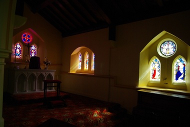
Digital photographs, L.J. Gervasoni, Infant Jesus Catholic Church Koroit interior, 2011-2016
http://vhd.heritagecouncil.vic.gov.au/places/69285 " ... the foundation-stone of the new church at Koroit was laid by Bishop Goold on New Year's Day, 1867. It was said of Fr. Parle that his one. fault was "extravagant ideas of church building," and to his vision must be attributed what was called at the time "the most magnificent and costly ecclesiastical building in the Western District." Altogether about £6000 was spent on the Koroit church, a large sum in those days. It entailed much delay while the money was being collected, and Fr. Parle did not live to see the completion of the great work he had undertaken. .. " (The Advocate, 13 August 1947.)Digital images of the interior of the Catholic church at Koroitchurch, catholic, koroit, infant jesus, presbytery, bluestone, interior, religion -
 Chelsea & District Historical Society Inc
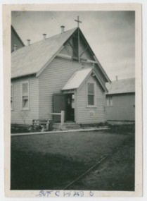
Photograph - St Chad's Church of England, Chelsea, Original Church Building, c 1950's
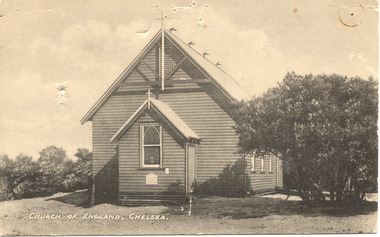
The foundation stone for St Chad's was laid on the 20th June 1914 and the church was completed and opened in August. The building was a wooden structure capable of seating about 150 people. The Church was built in Thames Promenade, Chelsea.Black and white photo of Chad's Church of England, ChelseaChurch of England, Chelseachurch of england, anglican, religion, building, church, chelsea -
 Chelsea & District Historical Society Inc
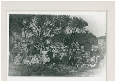
Photograph - St Chad's Church of England, Chelsea, Sunday School Group Photo, 1920's
The foundation stone for St Chad's was laid on the 20th June 1914 and the church was completed and opened in August. The building was a wooden structure capable of seating about 150 people. The Church was built in Thames Promenade, Chelsea.Black and white photo of children from the Sunday School at Chad's Church of England, Chelsea, in the ground of the church. Church of England, Chelseachurch of england, anglican, religion, building, church, chelsea, sunday school -
 Sunbury Family History and Heritage Society Inc.
Photograph, Bill Walls, Gap Gaol, c1970s
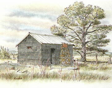
... building with a stone chimney and a corrugated iron roof. ... of a coloured watercolour of a small bluestone building with a stone ...Bill Walls is the artist who did the original watercolour of the small building, that was originally a gaol sited at The Gap settlement. The Gap, on the Calder Highway, preceded Sunbury's settlement and the gaol was used during the 1850s gold rush era, when the precious metal was being brought to Melbourne from the gold fields. In the 1990s the building was taken down brick by brick and rebuilt in the front of the Sunbury Police Station in Macedon Street.The Gap gaol building played a significant role in the development of the local area and is of local heritage significance.A photograph of a coloured watercolour of a small bluestone building with a stone chimney and a corrugated iron roof. the gap, police station, the gap gaol, gold rushes, sunbury -
 Chelsea & District Historical Society Inc
Photograph - St Chad's Church of England, Chelsea, Original Church Building, 1915
The foundation stone for St Chad's was laid on the 20th June 1914 and the church was completed and opened in August. The building was a wooden structure capable of seating about 150 people. The Church was built in Thames Promenade, Chelsea.Black and white photo of Chad's Church of England, ChelseaChurch of England, Chelseachurch of england, anglican, religion, building, church, chelsea -
 Stawell Historical Society Inc
Photograph, Pioneers’ Memorial on Big Hill -- during Construction
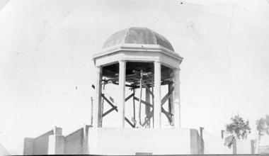
Pioneers’ Memorial under construction. The foundation stone was laid in 1935. This photo was loan for copying by Gwen ReeveBlack & white photograph of Pioneers memorial under construction. Scaffolding is under the dome of the building. There is also a jacket on the railing leading to the dome. stawell -
 Federation University Historical Collection
Photograph, Somerset Inn, Bannockburn
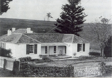
The Somerset Inn was built for Edward Carter Holmes by carpenter Isaac Sutherland and his two sons in 1855/1856. Situated on Bruce's Creek on the Shelford - Bannockburn Road. Bruce's Creek was the original name for current day Bannockburn. Black and white photograph of a house with slate roof and window shutters. The front fence is stone. The house is the former Somerset Inn (later a private residence). This building is located on the Leigh River at Bannockburn and was the home of Edward Carter and Sarah Holmes. Verso in blue ball point pen. "Somerset Inn on Leigh river Bannockburn. Home of Edward C. & Sarah Holmesholmes, leigh river, sarah holmes, ec holmes, holmes family collection, chatham-holmes family collection, edward carter holmes, farm, bannockburn -
 Federation University Historical Collection
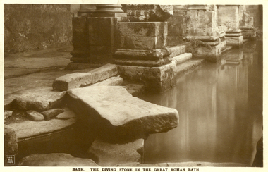
Postcard - Sepia, The Diving Stone in the Great Roman Bath, Bath, Somerset
The Great Bath is a massive pool, lined with 45 sheets of lead, and filled with hot spa water. It once stood in an enormous barrel-vaulted hall that rose to a height of 40 metres. For many Roman visitors this may have been the largest building they had ever entered in their life. The bath is 1.6 metres deep, which was ideal for bathing, and it has steps leading down on all sides. Niches around the baths would have held benches for bathers and possibly small tables for drinks or snacks. A large flat slab of stone is set across the point where hot water flows into the bath. It is known today as the diving stone. The Roman Baths complex is a site of historical interest in the English city of Bath. The house is a well-preserved Roman site for public bathing. The Roman Baths themselves are below the modern street level. There are four main features: the Sacred Spring, the Roman Temple, the Roman Bath House and the Museum, holding finds from Roman Bath. The buildings above street level date from the 19th century. Sepia postcard of a section of the Great Roman Bath at Bath, Somerset featuring the Diving Stone.printed verso: The Diving Stone in the great roman bath. The Diving stone, at the north-west corner of the great Roman Bath, still shows where the feet of bygone bathers wore away its surface. The hot mineral waters flowed into the bath through a channel under this stone. chatham-holmes family collection, bath, great roman bath, swimming pool -
 Federation University Historical Collection
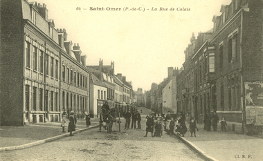
Postcard - black and white, Saint-Omer - Le Rue de Calais, c1913
Saint-Omer is a commune and sub-prefecture of the Pas-de-Calais department 68 km west-northwest of Lille on the railway to Calais. The town is named after Saint Audomar, who brought Christianity to the area. (Wikipedia) During World War I on 8 October 1914, the British Royal Flying Corps (RFC) arrived in Saint-Omer and a headquarters was established at the aerodrome next to the local race course. For the following four years, Saint-Omer was a focal point for all RFC operations in the field. Although most squadrons only used Saint-Omer as a transit camp before moving on to other locations, the base grew in importance as it increased its logistic support to the RFC. Many Royal Air Force squadrons can trace their roots to formation at Saint-Omer during this period. Among which are No. IX Squadron RAF which was formed at Saint-Omer, 14 December 1914 and No. 16 Squadron RAF which was formed on 10 February 1915. (Wikipedia)Black and white postcard showing a group of children and some adults surrounding a horse drawn cart. The cobble stone street is lined with double story buildings. chatham-holmes family collection, saint-omer, world war, world war 1, postcard -
 Ithacan Historical Society
Photograph, Panagias Monastery, Ithaca, Late 20th century
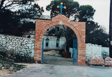
The photograph is of the entrance to the Monastery of Panagia Kathariotissa which is situated the south eastern peak of the Homeric Mount Neritos at an altitude of approx 600. The bell tower offers the most commanding panoramic view of the island. Panagia Kathariotissa is the protector saint of Ithaca and every year on 8th September Ithacans from across the island as well as visitors from elsewhere observe the feast day of the monastery. The night before a traditional feast is held in the courtyard, followed the next day, by the litany of the miraculous icon.A coloured photograph of an arched brick entrance with a cross above the arch. Old stone walls are on either side of the entrance with an old white building in the background . A negative accompanies the photograph -
 Ithacan Historical Society
Photograph, Frikes, Ithaca, c1970s
As the closest port to the mainland and neighbouring island Lefkada, Frikes was historically a trading port, supplying produce and merchandise to northern Ithaca. Today it is more a quiet fishing village which comes alive during the summer months with cafes and taverns. In summer tourist yachts moor at Frikes and a ferry service operates to Lefkada. A coloured photograph of he harbour at Frikes. Thee is a stone and concrete breakwater in the foreground where three fishing boats and a yacht are moored. A sedan is parked on the breakwater. Buildings are around the water's edge in the middle distance against a backdrop of mountains. ports, frikes -
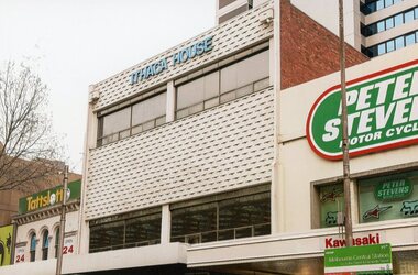 Ithacan Historical Society
Photograph, Ithaca House, 2016
... their own club rooms. A three storey building, a stone's throw from ...Ithaca House located at 329 Elizabeth Street Melbourne has been the site of the clubrooms of the Ithacan Philanthropic Society since 1958. Over the decades the club rooms have served as a meeting place and a venue for many social, cultural and fundraising activities. Prior to the building of Ithaca House, the clubrooms been located at Michael's Building, corner Lonsdale and Elizabeth Streets since 1917.In 1956, the Ithacans of Melbourne purchased a site, formerly two shops, at 329-335 Elizabeth Street for £35,000, with a view to building their own club rooms. A three storey building, a stone's throw from the old Michael's clubrooms, was finally erected in 1958 at a cost of £25,000. This was achieved by capital raising from the membership in the form of non-redeemable £10 and £50 debentures (1957-58). Plans were drawn up by the Australian born and newly qualified Ithacan architect, Nicholas Sofarnos (Sofianos). The then President Eustathios (Stathis) Vlassopoulos was key driver of the project. A colour photograph of the front upper stories of Ithaca House