Showing 1474 items matching "view hill"
-
 Ballarat Heritage Services
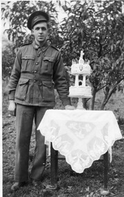
Photograph - Black and White, Vince Gervasoni and his 21st birthday cake
Vince was the youngest son of John and Catherine Gervasoni, and the grandson of Luigi Gervasoni. Black and white photograph of Vince Gervasoni in World War 2 AIF uniform, standing next to his 2 tier 21st birthday cake. The photograph was taken in the back yard of his famile's Yandoit Creek farm 'Pine View'. yandoit creek, vince gervasoni, birthday cake, world war 2 -
 Ballarat Heritage Services
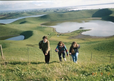
Photograph - Photograph - Colour, Kathleen Gervasoni, Red Rock, Alvie, 1989, 02/09/1989
Red Rock, Alvie, near Colac, is a complex of approximately 30 volcanic eruption points and is the Southern most of a chain of three volcanoes, the others being Warrion Hill and Alvie Hill. It is arguably the youngest eruption point in Victoria at around 8000 years, especially since the age of Mt Napier has been progressively pushed back. The highest point (on the Northern side) has many interesting features, including some awesome spatter ramparts. Driving around the rim to the south, you can also see layered tuff. There are some good views out to Lake Corangamite and the lava flows (probably from Warrion Hill) can be seen where they have entered the lake. Most of Red Rock is in private land, with two lookout points with some interpretive information. The water depicted in this photograph is not evident in 2019. Type: Volcanic Complex Location: South of Alvie, Victoria Last Eruption: 8000 years ago Access: Mostly private land, but there is an access road and some interpretive signage Visited: Visited Colour photograph of sisters Clare Gervasoni (left), Ann Gervasoni (centre) and Lisa Gervasoni and Red Rock, Alvie clare gervasoni, lisa gervasoni, ann gervasoni, red rock alvie -
 Ballarat Heritage Services
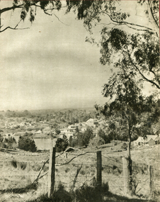
Photograph - Image - Black and White, View Towards Lake Daylesford, Victoria, c1950, c1950
A black and white image of Dayleford, looking towards the lake/.daylesford, lake daylesford -
 Ballarat Heritage Services
Photograph - Colour, View from St Joseph's Catholic Church, Blampied, 2019, 11/05/2019
Colour photographs of Blampied taken from St Joseph's Catholic Church. st joseph's blampied, st joseph's mount prospect, catholic church, bluestone, church -
 Ballarat Heritage Services
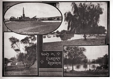
Photograph - Image, Eureka Stockade Reserve
Views in Eureka Reserve uncluding the Eureka Monument and Lake Penhalluriack.eureka gardens, eureka stockade memorial gardens, lake penhalluriack, eureka monument, eureka stockade, eureka stockade reserve -
 Ballarat Heritage Services
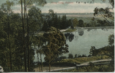
Photograph - Postcard, Gong Gong, Ballarat, 1908
Gong Gong was a locality in Ballarat East, near Fellmongers. A reservoir was built there. Situated only 10 minutes drive from the Ballarat CBD. In 2019 Gong Gong Reservoir Park is set in natural bush surrounds. There are scenics views, picnic and BBQ facilities with toilet facilities available on weekends. It is located along the Yarrowee River.photograph of Gong Gong reservoir 1908Gong Gong Ballarat - 13-4-1908 verso - note to Miss M I Wise, Gutheridge Parade, Salew. hewitt's yarrowee soap works, fellmongery, tannery, gong gong, mair street, daylesford road, o'deas, kinnane's, quin's, nestors -
 Ballarat Heritage Services
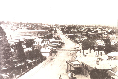
Image, View of Ballarat East from from the Fire Brigade Tower, c1895, c1895
Black and white image of the view of Ballarat East along Main Road. The photograph was taken from the Ballarat Fire Brigade Tower.ballarat east, main road ballarat east, ballarat fire brigade, phoenix hotel -
 Ballarat Heritage Services
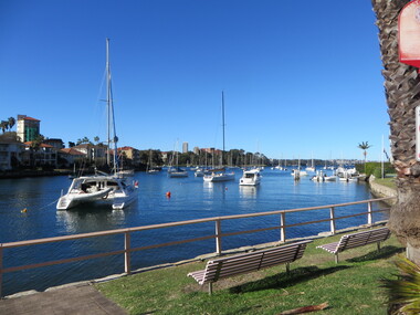
Photograph - Colour, View from the Flying Squadron Club, Kirribilli, 2019, 14/07/2019
Colour photograph of the view from the Flying Squadron Club, Kirribillisydney, flying squadron, kirribilli, sailing -
 Ballarat Heritage Services
Photograph - Colour, Ann Gervasoni, Rome, 2017, 22/2017
Colour photographs of views around Rome, Italy.rome, italy, trevi fountain, vatican -
 Ballarat Heritage Services
Photograph - Colour, Clare Gervasoni, Views from Dyson Drive, Luas, 2018
A number of colour photographs showing the urban creep bording farmland at Lucas, a suburb of Ballarat.dyson drive, lucas, farmland, urban sprawl -
 Ballarat Heritage Services
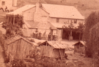
Photograph - Sepia, Bergamo House, Yandoit Creek
Photograph of the back view of Bergamo House, the home of Luigi and Eliza Gervasoni. Their Australian born son, George Gervasoni, sits on a horse in the background.yandoit, luigi gervasoni, eliza gervasoni, eliza ritzau, george gervasoni -
 Ballarat Heritage Services
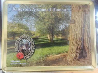
Photograph - Photograph - Colour, Kingston Avenue of Honour Centenary Biscuit Tin, 2018, 06/2018
This biscuit tin was produced to celebrate the Centenary of World War One. Image of a biscuit tin showing a view of the Kingston Avenue of Honour. kingston, kingston avenue of honour, world war one, centenary -
 Ballarat Heritage Services
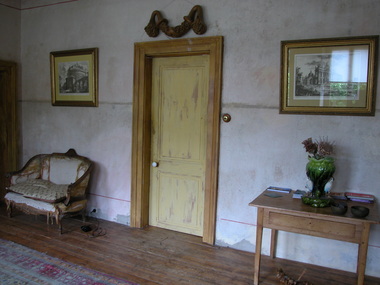
Photograph - Colour, Clare Gervasoni, Villa Parma, Hepburn Springs, 2005, 12/10/2005
Parma House was bult by Italian born Fabrizio Crippa. It was restored from a burnt wreck to Villa Parma by Richard Rigby and Franchek. Walls were scraped back to the original, and burnt umber detailing added. The garden was created by Richard Rigby and Kevin Flintoff.View from the second storey window of Parma House, Main Road, Hepburn Springs.villa parma, fabrizio crippa, parma house, richard rigby, kevin flintoff, garden, hepburn springs -
 Ballarat Heritage Services
Photograph - Colour, Clare Gervasoni, Interior of Villa Parma, Hepburn Springs, 2005, 12/10/2005
Parma House was bult by Italian born Fabrizio Crippa. It was restored from a burnt wreck to Villa Parma by Richard Rigby and Franchek. Walls were scraped back to the original, and burnt umber detailing added. The garden was created by Richard Rigby and Kevin Flintoff.Interior view of the interior of Parma House, Main Road, Hepburn Springs.villa parma, fabrizio crippa, parma house, richard rigby, kevin flintoff, garden, hepburn springs, foyer -
 Ballarat Heritage Services
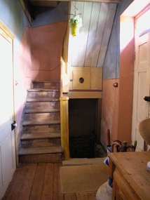
Photograph - Colour, Clare Gervasoni, Interior Staircase at Villa Parma, Hepburn Springs, 2005, 12/10/2005
Parma House was bult by Italian born Fabrizio Crippa. It was restored from a burnt wreck to Villa Parma by Richard Rigby and Franchek. Walls were scraped back to the original, and burnt umber detailing added. The garden was created by Richard Rigby and Kevin Flintoff.Interior view of the staircase at Parma House, Main Road, Hepburn Springs.villa parma, fabrizio crippa, parma house, richard rigby, kevin flintoff, garden, hepburn springs, foyer -
 Hume City Civic Collection
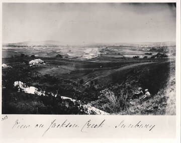
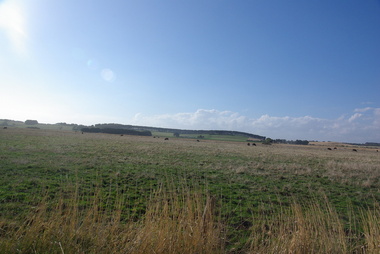
Photograph - View of Jackson Creek Sunbury, c1870
The photograph was taken on a rise overlooking the early settlement of Sunbury with Mount Holden and other hills across the skyline. The five arch railway bridge is visible in the distance on the RHS of the image. Two of Sunbury's early hotels, the John Franklin and the Ball Court are across the middle distance. Craiglee Vineyard with the vines growing is in the foreground. A black and white photograph with a white border.Written across the bottom: VIEW OF JACKSON CREEK SUNBURYsunbury, vineyards, jackson creek, craiglee vineyard -
 Ballarat and District Irish Association
Photograph - Colour, Clare Gervasoni, Crossley near 'Hillside" McCartney's Lane, 2014, 04/04/2014
Before 1941 "Hillside", McCartney's Road was associated with the Carroll Family. Patrick Edmund Carroll, his wife Mary Matilda Fitzgerald, and children Kathleen, Ronald and Rosemary were the last members of the family to live at and work "Hillside". Stanislaus Kelly and his wife Margaret (nee Gorman) bought the farm from the Carroll family. The couple raised six children on the land: May, Mary, Leo, Ray (Lofty), Daniel (Tich) and Bernadette. The family grew spuds and onions on the hill and milked cows, with the little dairy located on the eastern side of the house. (information from Mary Kelly)Colour digital photographs of Crossley, Victoria, near McCartney's Lane. The house depicted is "Hillside" in McCartney's Lane. The views towards an extinct volcano is Tower Hill.crossley, hillside, carroll, tower hill, mccartney's lane -
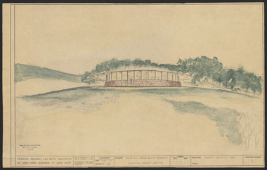 Robin Boyd Foundation
Drawing - External perspective, Tower Hill Lake Reserve Museum, Jun-61
In 1961 Robin Boyd designed the Tower Hill Reserve Visitors Centre to fit naturally within the surrounding terrain. The building’s shape reflects a volcanic cone. The windows allow a 360-degree view of the park. The Centre opened just after Robin Boyd’s death in October 1971. Project: Tower Hill Lake Reserve Museum drawn by Robin Boyd of Grounds, Romberg & Boyd. Drawing no 2. General view and external perspective. Watercolour on dyeline. tower hill, robin boyd, ohm2022, ohm2022_15 -
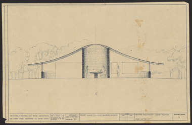 Robin Boyd Foundation
Drawing - External perspective, Tower Hill Lake Reserve Museum, Jun-61
In 1961 Robin Boyd designed the Tower Hill Reserve Visitors Centre to fit naturally within the surrounding terrain. The building’s shape reflects a volcanic cone. The windows allow a 360-degree view of the park. The Centre opened just after Robin Boyd’s death in October 1971.Project: Tower Hill Lake Reserve Museum drawn by Robin Boyd of Grounds, Romberg & Boyd. Drawing no 3. Watercolour on dyelinetower hill, robin boyd, ohm2022, ohm2022_15 -
 Mt Dandenong & District Historical Society Inc.
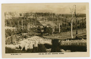
Photograph, 'O'er Hill and Dale,' Sassafras. Victoria, c1920
View of Sassafras showing many dead trees c1920s.Sepia coloured Rose Series postcard P. 153 looking down across Sassafras.On reverse REAL PHOTO POST CARD. THE "ROSE' SERIES DELUXE. PRODUCED IN AUSTRALIA. PUBLISHED BY 'THE ROSE STENOGRAPHS" Armadale. Victoriasassafras -
 Mt Dandenong & District Historical Society Inc.
Photograph, View of the Kalorama Valley c1905
John Lundy-Clarke grew up in the Kalorama/Mt Dandenong area and later in life (1972-74) began to write a comprehensive history of the area working from an original settlement map in an effort to cover all areas. This photograph c1905 is looking up from George Barber's house 'Forest Edge' on Barbers Road. 'Forest Edge' was built c1898 and was the home of George Barber and his wife Sarah Ann (nee Richardson). The buildings in the foreground are the stables and hayshed.Black and white photograph showing two small buildings in the foreground with cleared hills behind. Handwritten decription on back by John Lundy-ClarkeA 1905 view of the Kalorama Valley towards the Gap. Barbers stables in foreground with hayshed on left. Tait’s house in centre of picture with Logans in the same fold above the hayshed. “Kalorama” is centre of Gap with Paynter’s “Iona” on its left with stables to its left. It was from one of these trees on the top left that the runaway log was cut that leaped over Barbers Road (at the top edge of the cleared land) then over Logan’s house in one bound in 1930.george barber, sarah ann barber, john lundy-clarke, forest edge -
 Mt Dandenong & District Historical Society Inc.
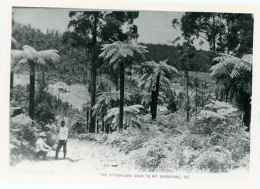
Photograph, View From Doughty's Road 1913
Mt Calvin, the homestead of Jeanie and Willie Richardson can be clearly seen in the clearing above the men in the picture. The white roof of the Barber homestead is on the right of the picture. A landslide in 1934 destroyed the tree ferned area. John Lundy-Clarke grew up in the Kalorama/Mt Dandenong area and later in life (1972-74) began to write a comprehensive history of the area working from an original settlement map in an effort to cover all areas.Black and white photograph that is a copy of a Rose series postcard titled 'The Picturesque Road to Mt. Dandenong. Vic.' It shows two men (probably Rose Series employees), one sitting and one standing at the edge of an unmade road. Large tree ferns line the roadside. Handwritten inscription on reverse by John Lundy-Clarke1913 View east from Doughty’s Road showing Jeannie Richardson’s home through the gap in the trees. A little to the right of and below centre of picture can be seen George Barber’s home with Barbers Road turning around the wagon shed that was a little up the hill from the house. The tree ferns in the picture were destroyed in the landslide of 1934. In the distance at the right can be seen F.M. Childs Homestead complex with the Richardson paddocks beyond it.mt calvin, jeanie richardson, willie richardson, george barber, landslide, tree fern -
 Mt Dandenong & District Historical Society Inc.
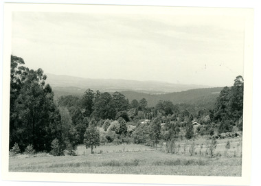
Photograph
In 1913 Edgar Dower took a photograph from this spot on Ridge Road that became known as Point Clear showing the Mt Dandenong township behind a stand of tall, dead trees. John Lundy-Clarke took this photograph from a similar spot at the Mt Dandenong Arboretum in 1975.Black and white photograph showing a cleared area in the foreground with young tress in the centre and hills in the distance. Several rooftops can be seen mid photo on the right. Reverse of photograph has handwritten description by John Lundy-Clarke.1975 View from the Arboretum over Mt D'nong township at the spot where Edgar Dower took the 1913 photo. The Falls gully is in the middle distance. Peter Damman's fence running downhill right foreground.edgar dower, point clear, mt dandenong, john lundy-clarke, peter damman, arboretum -
 Mt Dandenong & District Historical Society Inc.
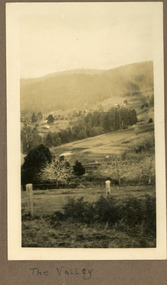
Photograph
The photograph is from the album of Ivy Child and shows a view across the Kalorama Valley sometime between 1927 and 1932. Ivy May Child (1910 – 1989) was the daughter of Arthur Edward (Ted) Child (1878 – 1964) and Ethel May Madden (1888 – 1970). Ted Child was the son of Matthew Francis Child (1839 – 1933) and Martha Jeeves (1857 – 1926). He was the grandson of one of the early pioneers Francis Child. Ivy grew up on the family property on Childs Road and took many photographs. Most of these are glued into her photo album. The album covered the years from c1927 – 1932. Ivy married Henry William Burgess (1906 – 1968) in 1944. The photographs remain in their original state in the album with individual copies made. Sepia coloured photograph with a wire and pole fence in the foreground of a sweeping view across a valley. Numerous roof tops are visible in the distance. The land has been cleared. Hills are in the distance.Written below the photograph in the album: The Valleykalorama valley, kalorama, ivy child -
 Mt Dandenong & District Historical Society Inc.
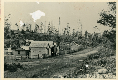
Photograph, Main Street Olinda c1908
c1908 view of Main Street Olinda with Dodd's store in foreground and Olinda State School up on the hill. Reverse of photograph has handwritten description by John Lundy-Clarke.Photo of Olinda taken about 1908 showing State School on skyline. Dodd’s store in foreground. Hodges blacksmith shop on roadside right. Coonara Road, then Mernda Road leads up out the picture right, Mt Dandenong Road goes down left. Range Road (the bullock track) is in immediate foreground and Sassafras turns to the right before the visible tracks on Mernda Road.olinda, jack dodd, general store, school -
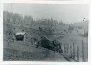
 Mt Dandenong & District Historical Society Inc.
Photograph, 1920s view of Kalorama FiveWays, c1920
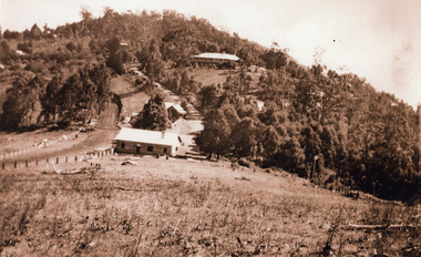
North view Mountjoy complex, Post Office and Store at FiveWays. Mountjoy Guest-house on hll with Jeeves Coach Service.Black and white photograph looking up hill towards guest house with two smaller buildings clearly visible in foreground and several roof tops in distance.ellis jeeves, fiveways, guest house, jeeves, mountjoy, post office, coach service -
 Mt Dandenong & District Historical Society Inc.
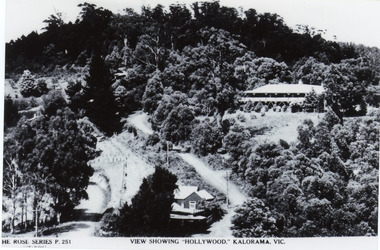
Photograph, View Showing 'Hollywood' Kalorama, Vic
Copy of Rose Series postcard #251 showing 'Mountjoy' named as 'Hollywood'. Mount Dandenong and Ridge Roads are visible at the FiveWays intersection along with the TeaRoom/Post Office. c1940Black and white photograph of a bushed setting with a building centre front and another, larger building up hill on RHS. Two unmade roads are visible with fences and telephone/power poles.The ROSE SERIES P. 251 VIEW SHOWING "HOLLYWOOD". KALORAMA, VIC.rose series, fiveways, guest house, mt dandenong road, ridge road, post office, hollywood, tea rooms, mountjoy -
 Mt Dandenong & District Historical Society Inc.
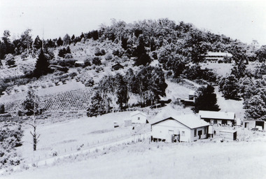
Photograph, View of Raspberry Crop and Orchard in Price Family Property
... and Mountjoy Guest House up on hill. View of Raspberry Crop and Orchard ...Wide view showing raspberry crop and orchards on Price Family property with home of Norman Jeeves in foreground and Hubert Jeeves' Motor garage to the left. Long, dark building is now gallery. Tea House/Post office right of centre and Mountjoy Guest House up on hill. fiveways, jeeves, mountjoy, orchard, tea rooms, price, crop -
 Mt Dandenong & District Historical Society Inc.
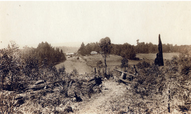
Photograph, Mountain Grange and Great Barn Kalorama
Copy of a postcard titled "Looking Towards Healesville". View taken from "Cherry Farm" hill looking across farm (now the Kalorama Memorial Reserve), which was the property of Thomas and Eliza Hand. Location recognised because of likeness to a painting.eliza hand, mountain grange, thomas hand -
 Mt Dandenong & District Historical Society Inc.
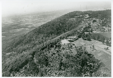
Photograph, View Towards Mt Dandenong 1961, 1961
... 1961. Viola Court in foreground, Ridge Road winding up the hill ...Looking north towards Mt Dandenong 'City Lights' estate 1961. Viola Court in foreground, Ridge Road winding up the hill towards the Observatory.mount dandenong, ridge road, viola court, city lights estate