Showing 27615 items
matching yarra-river
-
 Greensborough Historical Society
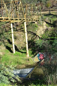
Photograph - Digital Image, Marilyn Smith, Plenty River at the aqueduct crossing Greensborough 2019, 02/07/2019
The Plenty River at the aqueduct crossing, 2019, showing graffiti on the river bank rocks. Originally part of the Maroondah Aqueduct pipeline, all that remains is the bridge that once carried the pipe over the Plenty River. This photograph was taken from the Plenty River Trail in Greensborough. 2 colour digital photographsplenty river trail, maroondah pipetrack, maroondah aqueduct, plenty river, graffiti -
 Eltham District Historical Society Inc
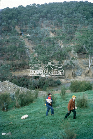
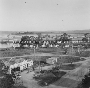
Slide - Photograph, View towards Garden Hill, Eltham-Yarra Glen Road, Kangaroo Ground, c.May 1988
Looking towards the Shire of Eltham Memorial Park on top of Garden Hill,, Eltham-Yarra Glen Road, Kangaroo Ground, c.May 1988. Viewed from near intersection of Kangaroo Ground-Warrandyte Road and Eltham-Yarra Glen Road35mm colour positive transparency (2 of 36) Mount - Kodak KodachromeProcess Date MAY 88Meltham-yarra glen road, kangaroo ground, shire of eltham memorial park, shire of eltham war memorial -
 Eltham District Historical Society Inc
Slide - Photograph, View towards Garden Hill, Eltham-Yarra Glen Road, Kangaroo Ground, c.May 1988
Looking towards the Shire of Eltham Memorial Park on top of Garden Hill,, Eltham-Yarra Glen Road, Kangaroo Ground, c.May 1988. Viewed from near intersection of Kangaroo Ground-Warrandyte Road and Eltham-Yarra Glen Road35mm colour positive transparency (2 of 36) Mount - Kodak KodachromeProcess Date MAY 88Meltham-yarra glen road, kangaroo ground, shire of eltham memorial park, shire of eltham war memorial -
 Greensborough Historical Society
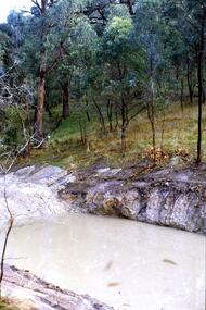
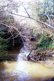
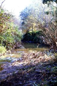
Slide - Photograph, John Ramsdale, Plenty River: Slide 105, 1990s
Photograph shows a river and bank (Plenty River) with some rubbish.Part of the John Ramsdale collection of slides and audio visual material.Colour photograph scanned from slide.No maker's marks. No caption on slide.plenty river, pollution -
 Greensborough Historical Society
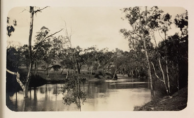
Slide - Photograph, John Ramsdale, Plenty River catchment: Slide 123, 1990s
Photograph shows a river and bushland, part of the Plenty River catchmentPart of the John Ramsdale collection of slides and audio visual material.Colour photograph scanned from slide.No maker's marks. No caption on slide.plenty river -
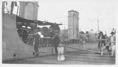 Port Fairy Historical Society Museum and Archives
Photograph, HMAS Yarra
H.M.A.S. Yarra on goodwill visit to Port Fairy 1921A rare image of a war ship anchored at the Moyne river wharfBlack& White photographship, boat, sea, river, hmas yarra, moyne river -
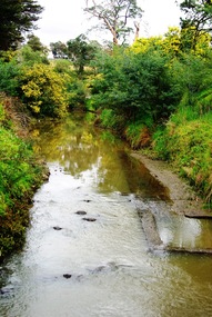
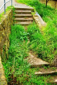 Greensborough Historical Society
Photograph - Digital image, Marilyn Smith, Plenty River bank stabilisation 2015; Steps to path, 16/08/2015
This photo shows the steps to the path beside the Plenty River in Greensborough. A River bank stabilisation project along the Plenty River at Greensborough was conducted by Melbourne Water in 2015.Digital copy of colour photographplenty river, melbourne water -
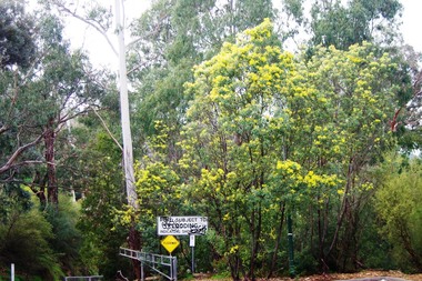
 Eltham District Historical Society Inc
Slide, Site of proposed Yarra Brae Dam, Jul. 1973
With an increasing need to grow Melbourne's water supply, in 1973, the State Government announced plans for the development of Sugarloaf Reservoir. Two dams were to be built, one across the Yarra from the Yarra Brae property in Wonga Park to the Bend of Isles. Water was to be pumped from this dam to the higher level Sugarloaf Reservoir. The proposed extensive flooding of large numbers of properties resulted in significant community backlash and ultimately abandonement of the proposed Yarra Brae dam.35 mm colour positive transparency (x 3) Mount - Kodak Kodachrome Cardyarra brae dam -
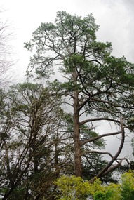 Greensborough Historical Society
Photograph - Digital image, Marilyn Smith, Plenty River bank at Greensborough 2015; Tree, 16/08/2015
This photo shows examples of trees growing beside the Plenty River in Greensborough. A River bank stabilisation project along the Plenty River at Greensborough was conducted by Melbourne Water in 2015.Digital copy of colour photographplenty river, melbourne water -
 Greensborough Historical Society
Slide - Photograph, John Ramsdale, Plenty River near Apollo Parkways: Slide 128, 1990s
Photograph shows a river and trees - the Plenty River near Apollo Parkways.Part of the John Ramsdale collection of slides and audio visual material.Colour photograph scanned from slide.No maker's marks. No caption on slide.plenty river, apollo parkways -
 Kew Historical Society Inc
Photograph - Yarra River, Kew, 1925
Henry Beater Christian (1886-1962) , was a descendant of one of the earliest settler families in Kew. Employed at the Kew Asylum as a 'public servant', he was a skilled amateur photographer, photographing numerous scenes in Kew and on his travels around Victoria. The majority of his photographs date from 1916 to 1929. His finest photographs are housed in two photograph albums. Digital copy of a photograph from page 3 of the 47-page photograph album containing 261 gelatinous silver images, loaned by Diane Washfold with permission given to digitise and hold a copy in our collection. A photograph of a stretch of the Yarra River at Kew. In the distance rises J Lewis Carnegie's mansion 'Carnsworth' in Stawell Street."Yarra Rvr / Kew / 1925"henry beater christian (1886-1962), landscape photography, kew (vic.) — yarra river, christian-washfold collection, photograph albums, carnsworth -
 Warrnambool and District Historical Society Inc.
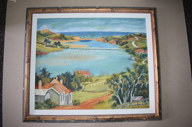
Framed Paintings, 1 The Frame Shop, Fairfield, Melbourne .2 Kardinia Picture Framing, Geelong, 1Warrnambool Botanical Gardens .2 Hopkins River, Warrnambool, 1953
These two works of art are by Dr Don Edgar, a sociologist, educator and author. He taught sociology at Stanford University, the University of Chicago, Monash University and La Trobe University and was the founding Director of the Australian Institute of Family Studies. In the 1950s Dr Edgar was a student at Warrnambool High School and these works of art were produced at that time. For a school project he researched the early history of the Warrnambool Art Gallery and some of its collection, dating from the 19th century. In 2019 he published a book, ‘Art For the Country’, the story of Victoria’s regional art galleries and the book includes information on the founding and the later history of the Warrnambool Art Gallery.These works of art are of interest as they were painted by Dr Don Edgar, a noted academic and author today and a former resident of Warrnambool. The two works of art also have historical interest as they depict Warrnambool scenes painted over 60 years ago. .1 An art work (oil on artboard) – the Warrnambool Botanical Gardens with bridge and reflections, a gum tree and a poplar tree, all in green and orange tonings. The wooden frame has a light varnish with gold and white trim .2 An art work (oil on artboard) – multi-coloured view of the mouth of Hopkins River with the Hopkins River bridge, Lyndoch bungalow and boathouse. The frame is wooden with a mottled varnish and a white insert edging. .1 Don Edgar 1953 Don Edgar 1953 (High School Student) .2 D.E. 53 Don Edgar 1953 (High School Student) dr don edgar, sociologist, author and educator, warrnambool art gallery, history of warrnambool -
 Eltham District Historical Society Inc
Negative - Photograph, J.A. McDonald, Yarra Glen-Yea Road, Dixons Creek, June 1958
Dixon's Creek Yarra Glen-Yea Road June 1958Record of various Shire of Eltham infrastructure works undertaken during the period of 1952-1962 involving bridge and road reconstruction projects, sometimes with Eltham Shire Council Project Reference numbers quoted. It was during this period that a number of significant improvements were made to roads and new bridges constructed within the shire that remain in place as of present day (2022). In many situations, the photos provide a tangible visible record of infrastructure that existed throughout the early days of the Shire. The album was put together by or under the direction of the Shire Engineer, J.A. McDonald.infrastructure, shire of eltham, 1958-06, bridge construction, dixons creek bridge, dixon's creek road, yarra glen-yea road -
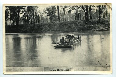 Orbost & District Historical Society
black and white photograph, late 19th century
A punt crossed the Snowy River at Orbost from 1884. A bridge was constructed in 1893, but was soon damaged by a huge flood. Flooding was a regular occurrence, the worst inundations being in 1870, 1893, 1925, 1934, 1952 and 1971. Over the years major flood protection works have been implemented. The Princes Highway, which passes Orbost, now crosses the flood plain on raised concrete supports. (info, from Victorian Places Orbost)This item is associated with the Snowy River and its history. It is a pictorial record of transport in the late 19th century.A black / white photograph (copy) of a punt loaded with people and a horse-drawn carriage making its way across a river.on front at bottom - "Snowy River Punt"snowy-river-orbost transport shipping -
 Greensborough Historical Society
Slide - Photograph, John Ramsdale, Plenty River behind football ground: Slide 51, 1990s
Photograph shows a river and bushland. This is the Plenty River behind the football ground in Greensborough.Part of the John Ramsdale collection of slides and audio visual material.Colour photograph scanned from slide.No maker's marks. Caption on slide "Plenty"plenty river greensborough, plenty river -
 Greensborough Historical Society
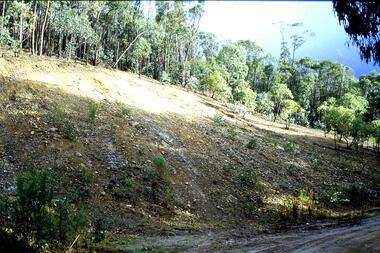
Slide - Photograph, John Ramsdale, Headwaters of the Plenty River: Slide 81, 1990s
Photograph shows hill with trees and run off to the river. This is the headwaters of the Plenty River.Part of the John Ramsdale collection of slides and audio visual material.Colour photograph scanned from slide.No maker's marks. No caption on slide.plenty river -
 Greensborough Historical Society
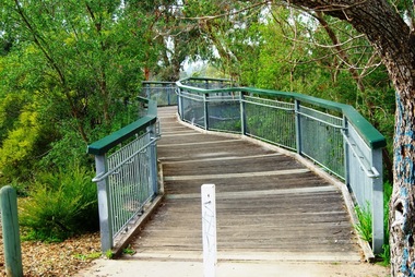
Photograph - Digital image, Marilyn Smith, Partington's Flat: footbridge over the River, 16/08/2015
Partington's Flat. This photo shows the footbridge over the river on the Plenty River Trail.Digital copy of colour photographspartingtons flat, plenty river trail, plenty river -
 Greensborough Historical Society
Photograph - Digital image, Marilyn Smith, Partington's Flat: River crossing / floodway, 16/08/2015
Partington's Flat. This photo shows the floodway / river crossing over the Plenty River.Digital copy of colour photographpartingtons flat, plenty river -
 Lakes Entrance Regional Historical Society (operating as Lakes Entrance History Centre & Museum)
Book, Bird E C F, The Silt Jetties at the Mitchell River, 1972
The first of a series of scientific and historical studies of Gippsland to be published by the Bairnsdale Advertiser. The formation of the Mitchell River Silt Jetties is explained, and schemes for protecting this unique and fragile area of Victoria are suRuth Clarkgenealogy, waterways, topography -
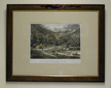 South Gippsland Shire Council
Lithograph, Wentworth River Diggings, 1864
Printed in 1864 by Nicholas Chevalier.Framed lithograph titled "Wentworth River Diggings Gippsland" Printed in 1864 by Nicholas Chevalier. Set in cream card window mount. Brown painted wood frame with gold edging. -
 Greensborough Historical Society
Photograph - Digital image, Marilyn Smith, Plenty River bank at Greensborough 2015; Rear of lower Main Street shops, 16/08/2015
The Plenty River embankment in Greensborough looking up to rear of lower Main Street shops. A River bank stabilisation project along the Plenty River at Greensborough was conducted by Melbourne Water in 2015.Digital copy of colour photographplenty river, melbourne water -
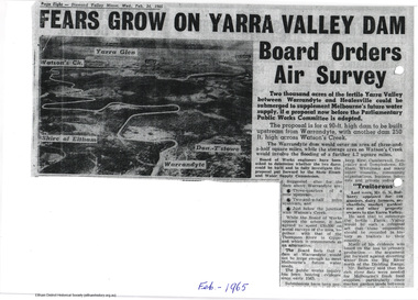 Eltham District Historical Society Inc
Newspaper articles, Yarra Dam
Two newspaper articles discussing the proposed construction of the Yarra Dam at Warrandyte: Yarra Dam at Warrandyte not the only alternative - Mr Stokes, Diamond Valley Mirror, 14 October, 1964 Fears grow on Yarra Valley Dam Board orders air surey, Diamond Valley Mirror, 24 February 1965 The Sugarloaf Reservoir Project, including a major pumping station and water treatment plant was completed, increasing Melbourne's total storage capacity by 95,000 million litres in 1981.2 pageswater supply, sugarloaf, reservoir, christmas hills, yarra dam, warrandyte -
 Greensborough Historical Society
Photograph - Digital image, Marilyn Smith, Old swimming pool in Plenty River at Greensborough 2015, 16/08/2015
Old swimming pool in the Plenty River in Greensborough, built of concrete in the 1930s, it was a popular spot for the locals. A River bank stabilisation project along the Plenty River at Greensborough was conducted by Melbourne Water in 2015.Digital copy of colour photographplenty river, melbourne water -
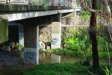 Greensborough Historical Society
Photograph - Digital image, Marilyn Smith, Railway Road Rail Bridge over Plenty River Briar Hill, 17/09/2014
Para Road bridge over Plenty River Greensborough, taken from the banks of the river.Digital copy of colour photographpara road greensborough, plenty river -
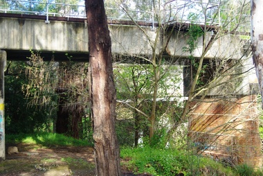 Greensborough Historical Society
Photograph - Digital image, Marilyn Smith, Railway Road Rail Bridge over Plenty River Briar Hill, 17/09/2014
Para Road bridge over Plenty River Greensborough, taken from the banks of the river.Digital copy of colour photographpara road greensborough, plenty river -
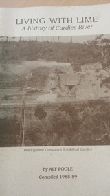 Peterborough History Group
Book, Living with lime: a history of Curdies River, 1988-89
History of the Curdies River and the growth of the lime industry and the people who lived along the river.56 page softcover book by Alf Poole, compiled 1988-89curdies river, lime industry victoria, dr curdie -
 Orbost & District Historical Society
programs, 1961
The Snowy River Shire was a local government area in the Australian Alps region of New South Wales, Australia from 1939 until May 2016. It was named after the Snowy River that runs through it. Prior to 1936, it had been named as Dalgety Shire since establishment in 1906. This opening of the Monaro - Gippsland Road took place on 4th May 1961. There had long been a movement in Monaro for the construction of a road to connect Monaro and Gippsland, via Inglebyra and Black Mountain. The only track was for stock, made by pioneers many years ago, and it was very circuitous. It was stated at a meeting at Dalgety that the road would open up large areas for settlement for grazing, and for timber suitable for bridgé building. The road would assist stock deal ing between Monaro and Gippsland. It would also considerably shorten the distance from Victoria for tourists visiting Canberra and Kosciusko. A committee was formed to put the proposal before the Dalgety Shire Council in the 1930s.This item is a useful research tool.Four copies of a road opening program. It has black print on white. There are black / white photographs, historical details and details of the official opening.program monaro-road snowy-river-shire -
 Eltham District Historical Society Inc
Album - Photograph, J.A. McDonald, Eltham-Yarra Glen Road, 3 Aug. 1956
Floods at Yarra Glen November, 1956 From top of Grand HotelRecord of various Shire of Eltham infrastructure works undertaken during the period of 1952-1962 involving bridge and road reconstruction projects, sometimes with Eltham Shire Council Project Reference numbers quoted. It was during this period that a number of significant improvements were made to roads and new bridges constructed within the shire that remain in place as of present day (2022). In many situations, the photos provide a tangible visible record of infrastructure that existed throughout the early days of the Shire. The album was put together by or under the direction of the Shire Engineer, J.A. McDonald.infrastructure, road construction, shire of eltham, bridge construction, eltham-yarra glen road, 1956-11, floods, floodwater, ford service garage, grand hotel, new holland, yarra glen -
 Marysville & District Historical Society
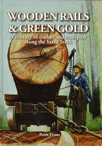
Book - Hardcover book, Peter Evans, Wooden Rails & Green Gold-A century of timber and transport along the Yarra Track, 2022
A history of the timber mills along the Yarra Track from Narbethong to Matlock.Hardcover. Shows Mick Taylor making last-minute adjustments to the rigging of a large log about to commence its journey down the incline to the Marysville Timber and Seasoning Company No.1 mill. Back cover has a photograph of a rail tractor towing a timber trolley along a timber tramway.non-fictionA history of the timber mills along the Yarra Track from Narbethong to Matlock.timber, timber mills, yarra track, narbethong, matlock, marysville, wood's point, wilks creek, great divide, cathedral range, cumberland, foresters, sawmillers, peter evans -
 Marysville & District Historical Society
Book - Hardcover book, Peter Evans, Wooden Rails & Green Gold-A century of timber and transport along the Yarra Track, 2022
A history of the timber mills along the Yarra Track from Narbethong to Matlock.Hardcover. Shows Mick Taylor making last-minute adjustments to the rigging of a large log about to commence its journey down the incline to the Marysville Timber and Seasoning Company No.1 mill. Back cover has a photograph of a rail tractor towing a timber trolley along a timber tramway.non-fictionA history of the timber mills along the Yarra Track from Narbethong to Matlock.timber, timber mills, yarra track, narbethong, matlock, marysville, wood's point, wilks creek, great divide, cathedral range, cumberland, foresters, sawmillers, peter evans