Showing 25227 items matching "north"
-
 Ballarat Tramway Museum
Document - Report, Australian Electric Traction Association (AETA), "AETA Report on passenger services- Geelong - April 1949", Apr. 1949
Report examining rail, tram and bus services to mainly North Geelong area. Drawing of PCC car- possibly a proposed MMTB car - 45' long. Looks at comparative costs, provision of rolling stock, recommendations for improvement, a comparison between buses and trams and the style of an operating authority other than the SEC. Follows on from the Mr. Hector Bell Jnr's report and comments on his report. See item 9819 for this report. Prepared by: Charles Craig (Chairman), Leon Marshall-Wood, Noel Gipps, Donald Wishart, John Beckett, John Stranger (Secretary) of the AETA. Yields information about the threats to the Geelong tram system in 1949 and ways that it could be upgraded and extended to continue to serve. Was the first of the SEC systems to close. Has a strong association with the AETA members.A 20 page report + index + cover sheet + drawing foolscap size + estimate - corner stapled. Second copy, original version, stapled in top left hand corner with rounded corners.trams, tramways, passenger services, geelong, reports, aeta -
 Warrnambool and District Historical Society Inc.
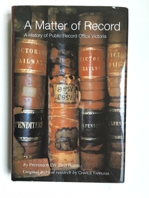
Book, A Matter of Record, 2003
This book gives the history of the Public Record Office, Victoria. It was written by Professor Bill Russell and produced in 2003. The research by Charlie Farrugia that enabled the book to be written was carried out entirely using the Public Record Office archives. The book documents the 1903 beginnings of the Public Record Office from a small collection in the possession of the Melbourne Public Library through to the important 1973 Victorian Public Records Act to the present day institution at North Melbourne. The Melbourne Public Library, the Historical Society of Victoria and the History School of the University of Melbourne were early contributors to the preservation of Victoria’s archives. This book is in the library of the Warrnambool and District Historical Society and is an important reference for us in regard to the history of archival preservation of historical documents in our State. In addition we are a Place of Deposit for historical records that are surplus to the requirements of the Public Record Office of Victoria and that concern more directly the history of Warrnambool and district. Many local Warrnambool and district residents use the facilities at the Public Record Office at North Melbourne and the link between that institution and Warrnambool historical groups is important. This is a hard cover book of 227 pages. The cover is black with gold lettering on the spine. The dust cover is dark red with printed material about the author and the book’s contents. The front of the dust cover has an illustration of four Victorian Railways ledgers in sepia tones and the back of the dust cover has a small illustration in brown and white of a heritage label. The book has a Contents page, an Acknowledgement page, a Foreword, an Introduction, eight chapters, Appendices, Notes and References and an Index. The book is a 2003 history of the Public Record Office of Victoria written by Professor Bill Russell and researched by Charlie Farrugia. Front Cover: ‘A Matter of Record, A History of Public Record Office Victoria by Professor E W (Bill) Russell, Original archival research by Charlie Farrugia.’ Spine: ‘A Matter of Record, Russell, Public Record Office Victoria’. public record office, professor bill russell, charlie farrugia, historical records of victoria -
 The Beechworth Burke Museum
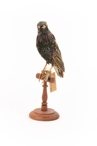
Animal specimen - Common Starling, Trustees of the Australian Museum, 1860-1861
Common Starlings are a noisy bird that typically inhabit urban and rural areas, especially those with short grass for easy foraging, though can occasionally be found in open forests or along costal areas. They are native to a wide area of Eurasia and the North of Africa, though have been introduced to North America, some nations in South America, Fiji, South Africa, Australia, and New Zealand. They live in large flocks that fly together in strong unison, and have a range of loud calls. Male Common Starlings usually have brown eyes, in contrast to the light coloured eyes of the taxidermy mount. Otherwise, the specimen bears a reasonable resemblance to a typical Common Starlings. This specimen is part of a collection of almost 200 animal specimens that were originally acquired as skins from various institutions across Australia, including the Australian Museum in Sydney and the National Museum of Victoria (known as Museums Victoria since 1983), as well as individuals such as amateur anthropologist Reynell Eveleigh Johns between 1860-1880. These skins were then mounted by members of the Burke Museum Committee and put-on display in the formal space of the Museum’s original exhibition hall where they continue to be on display. This display of taxidermy mounts initially served to instruct visitors to the Burke Museum of the natural world around them, today it serves as an insight into the collecting habits of the 19th century.This specimen is part of a significant and rare taxidermy mount collection in the Burke Museum. This collection is scientifically and culturally important for reminding us of how science continues to shape our understanding of the modern world. They demonstrate a capacity to hold evidence of how Australia’s fauna history existed in the past and are potentially important for future environmental research. This collection continues to be on display in the Museum and has become a key part to interpreting the collecting habits of the 19th century.This male Common Starling is covered in black feathers that each have a metallic orange edge. This gives the appearance of small dots across its head and neck, larger dots along its underbelly and back, and lines along the outer feathers of the wings. Its beak is yellow and its eyes are a light blue with a black pupil. The bird is stretched tall with its head turned towards the left and slightly tilted right. The specimen stands on a brown, wooden perch with a circular bar, curved stand, and circular base. The left leg has a metal tag and a swing-tag tied around it and the right leg has two swing-tags tied around it, one of which is torn.Metal Tag: 4256 Swing-Tag 1: Sturnus vulga[illegible]is / male, adult / 25 January 1861 / near Leiden / Swing-Tag 2: Tris grey-brown / Feet black - brown / Bill brown / 4256 / Swing-Tag 3 (torn): ng / e Page 58taxidermy mount, taxidermy, animalia, burke museum, beechworth, australian museum, skin, reynell eveleigh johns, bird, starling, european starling, common starling, european bird -
 The Beechworth Burke Museum
Photograph, 2000
Woolshed is a small area about five kilometres north west of Beechworth, and almost about 225km north east of Melbourne. When gold was discovered at the nearby Spring Creek in February 1852, Woolshed was one of three settlements set up to house miners and their families. At its peak in 1857, Woolshed was also populated by 29 storekeepers and 14 hotels, as well as the Woolshed State School, which stood near where this photograph was taken. The school often played host to public meetings, as well as a public dance in 1897. The school was subject to some controversy in 1874 when one parent complained about the head of the school in the local newspaper, the Owens and Murray Advertiser, and at least three letters to the editor were exchanged between the two. According to the parent, C. O'Donoghue was not providing enough amusement for the children and was disrespectful to parents and staff. When the State Governor, Sir Reginald Talbot, visited Beechworth in 1906, the school organised a celebratory welcome. The Woolshed State School was ultimately closed in 1922 as miners had exhausted the Spring Creek gold supply and were moving elsewhere. This photograph, taken in about 2000, shows the trees that grew on or near the site of the original school. The Woolshed State School Honour Roll, with a list of the men from the school who served in the First World War, also still exists. It is stored in the Beechworth RSL as of 2015.This photograph is significant for its connection to an important site in Beechworth's gold mining history. Woolshed served a significant community of miners, with a population of at least 138 according to the 1911 census, with families that needed the school site to ensure their children's education. The image is also useful for prompting discussion about how Beechworth has changed over time, with the photograph taken 78 years after the school closed down.A colour rectangular photograph printed on glossy photographic paper.Woolshed State. / School site / 2000 / - remnant trees / / cobeechworth, burke museum, school, education, trees, nature, state school, woolshed, gold mining, teachers, over time, owens and murray advertiser, public meetings, public dance, c. o'donoghue, spring creek, state governor, sir reginald talbot, miners, honour roll, world war 1 -
 The Beechworth Burke Museum
Photograph, Unknown
The A1 Gold Mine is located north of Woods Point, near Jamieson, in the Upper Goulburn region of Victoria. Gold was discovered at the A1 site in 1861 and mining operations began in 1864. The A1 Mine Settlement refers to a small township known variously as Castle Reef, Castle Point, and Raspberry Creek, which developed in the 1860s around mining industry centred on a crushing machine that worked the three gold reefs in the area. Historically, the name "A1"referred to the high quality of gold found in the quartz reefs at depths of at least two thousand feet. Along with the Morning Star mine at Woods Point, the A1 gold mine produced almost sixty percent of Victoria's gold output in the 1950s to 1970s and continued operating until 1992 when it went into administration. Operations at the site were revived in 2016 and the A1 Mine is now considered one of Victoria's premier gold mines. The A1 mine is part of the extensive and prospective Lachlan Fold Belt, a north-west trending belt of tightly folded Early Devonian sedimentary rocks extending from New South Wales to Victoria. Mineralisation is hosted within or immediately adjacent to diorite dykes. Contemporary development of the 'Queens Lode' at the A1 mine signals a move from high-grade, narrow vein airleg mining into larger scale, mechanical mining designed to increase ore production volume. This original, undated photograph of the A1 Mine appears to depict an area or phase of disuse or abandonment. The aged and humble appearance of the cottage suggests association with the historical A1 Mine Settlement, therefore the image may have been taken prior to the 1950s-1970s revival period in which the A1 mine is known to have produced high gold yields. The photograph contributes to our understanding of the A1 Gold Mine's impact on the landscape and the social, environmental impacts of mining on communities and may be compared with others in the Burke Museum's extensive collection of mining photographs to deepen our understanding of mining in the Jamieson area.Black and white rectangular photograph printed on photographic paperReverse: 5577 / A1 Mine / Near Jamieson / Vic. /burke museum, beechworth museum, beechworth, gold fields, gold rush, victorian gold rush, mining tunnels, gold ming history, colonial australia, australian gold rushes, mining technology, beechworth historic district, indigo gold trail, indigo shire, upper goulburn shire, jamieson, woods point-walhalla goldfield, a1 gold mine, victorian high country, modern mining methods, orogenic gold province, gold mineralisation, devonian, dykes -
 The Beechworth Burke Museum
Photograph
This photograph dating between the 1850s and early 1900s depicts an open cut sluicing site located in Allan's Flat looking upon the open cut from Staghorn Flat Number 1. Sluicing was undertaken in the area from 1850 to 1904. The image depicts a location mined by Yackandandah Sluicing Co. It portrays and open space with pipes laying on the ground and connected to pipes leaving the barge. These pipes were used to wash and seperate the qaurtz. There are two small buildings on high ground over looking the barge. Yackandandah Sluicing Co. was created by J.A. Wallace in the 1880s. The Yackandandah Sluicing Co. operated from the mid-1880s to the early 1900s, when resources eventually ran out. Open cut sluicing involved the use of high-powered hoses which used the centrifugal sand pump system (known as hydraulic sluicing) which broke down the soil which was then processed for quartz, gold and other materials. After the resources where drained, Wallace reaped the benefits of his mining business. Allan's Flat is located on the Yackandandah Creek, and is 10km north-east of Yackandandah and 20km south of Wodonga in Victoria's regional north-east. Allan's Flat was initially used to mine gold through alluvial methods, however that came to an end with little results. The mining business was then revived by J.A. Wallace with the introduction of hydraulic sluicing.The search for gold is ingrained into the history of Victoria and therefore, images like this one which portray an open cut sluicing site can reveal important information for society and technology for the date when the photograph was taken. This image is of important historical significance for its ability to convey information about sluicing and the methods used to find gold and other minerals in the lat 19th Century. It also shows a location where sluicing was undertook which provides insight into the impact of sluicing on the environment at a time when it was done. This image is important for current research into the history of Allan's Flat, a small regional location near Yackandandah in Victoria's North East. Therefore, this image has the capacity to be beneficial for research into society and the motivations of those living and working in this region during this period and therefore, has social significance. The Beechworth Burke Museum has additional images relating to gold sluicing and Allan's Flat which can be analysed and studied alongside images like this one.Sepia coloured retangular photograph printed on gloss photographic paper mounted on board.Revers: Sluicing at Allan's Fortallan's flat, north east gold, sluicing, gold sluicing, hydraulic sluicing, mining, gold and quartz mine, beechworth, burke museum, yackandandah -
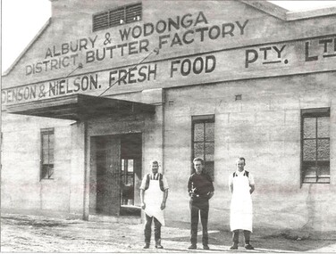 Wodonga & District Historical Society Inc
Photograph - Albury & Wodonga District Butter Factory
Holdenson and Nielson Fresh Food Pty Ltd was founded in 1903 by Poul Jorgenson Holdenson and Andrew Nielson, after acquiring the Fresh Food and Storage Co, which had plants throughout Australia, including Albury. The plant was moved to Wodonga that year. Cream was collected from all areas of North East Victoria and the Riverina, with contractors carting it to the railway stations for rail travel to Wodonga. The Butter Factory was built on the Lincoln Causeway in 1926, and the Cheese Factory in 1942 as a wartime emergency project. At the same time, a pasteurising plant was installed in the complex, and so whole milk was collected from dairy farmers, rather than just cream. The company was bought out by the North Eastern Dairy Co-operative in 1962. It became a retail milk depot also involved in ice-making and cold storage. In 1985, Goulburn Murray bought the complex and as the site was surplus to requirements, it was sold to Wodonga Council. The buildings were adapted for other uses. The Butter Factory was modified and extended and for some time was occupied by the Albury- Wodonga Visitor Centre. The Creator's Gallery was established in the engine room, and the loading area and ice-making works were extended and modified for use as the HotHouse Theatre. The Cheese Factory was adapted for use as a theatre and jazz venue, and housed the HotHouse office. The various outbuildings, such as garages and storage areas, were adapted for use as shops and craft outlets.This collection is significant because it documents an important industry in Wodonga.A collection of images and advertisements promoting Holdenson and Nielsen of Wodongaholdenson & nielson, wodonga dairies, victorian dairy industry -
 Melbourne Tram Museum
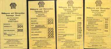
Ephemera - Timetables - MMTB Buses - set of 9, Melbourne & Metropolitan Tramways Board (MMTB), 1976 to 1978
Timetables - provide information on ticketing, fares, timing points, with a description of the route and a map. Not all services had been allocated a route number at the time. 1 - Garden City - Port Melbourne - City - routes 201 and 202 - Jan. 1977 2 - Bulleen - North Kew City - Routes 203, 204, 205, 206, 208 and 209 - Feb. 1977 3 - Deer Park West - Sunshine - Footscray - City - routes 215, 216, 217, 219. 218, 220, 231 with a Saturdays and Sundays timetable sheet printed on green paper - Aug. 1977 4 - La Trobe University - Northland - West Heidelberg - City - routes 256, 251, 253, 254, 252, 255 - Sept. 1978 5- Warrandyte - Park Orchards - Ringwood - routes 273, 274, 275 - June 1976 6 - Warrandyte - Donvale - Templestowe - Shoppingtown - City - routes 276, 277, 278, 294, 278, 280, 299, 268 - July 1976 7 - Box Hill - Mitcham, East Doncaster, Ringwood - routes 287, 286, 288, 282, 283, 272 - June 1976 8 - Box Hill - North Blackburn - route 290 - June 1976 9 - Box Hill - Heidelberg, East Doncaster, Shopping town - routes 291, 297, 296, 293, 271 and 269 - Sept. 1976Yields information about MMTB Bus services during the mid 1970s. Set of nine MMTB Bus timetables - multifolded printed on yellow paper, unless noted otherwise. timetable, mmtb, buses, port melbourne, garden city, deer park, fisherman's bend, west heidelberg, box hill, doncaster, shoppingtown, mitcham, ringwood, blackburn, templestowe, lower templestowe -
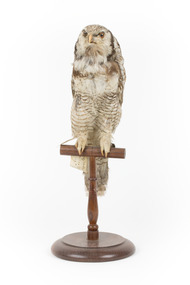 The Beechworth Burke Museum
Animal specimen - Northern Hawk Owl, Trustees of the Australian Museum, 1860-1880
The Northern Hawk-owl is a nomadic and generally solitary bird, although they can occasionally be seen in pairs. While these birds resemble owls, their behaviour is more similar to that of a hawk, hence their name. Normally active during the day (similar to the hunting habits of a hawk), they prefer to reside in boreal forest, grasslands, shrublands and temperate, cold and polar zones. Located in North America, Europe and Asia, these owls can also occasionally be found during migration, in the northern United States. There are three subspecies in North America, Central Asia and Siberia. At the present time (2021), its numbers are stable and so it is therefore considered of ‘least concern’ on the IUCN Red List, indicating it is not yet endangered. This particular specimen has been correctly mounted and presented as a relatively accurate representation of the actual bird. This specimen is part of a collection of almost 200 animal specimens that were originally acquired as skins from various institutions across Australia, including the Australian Museum in Sydney and the National Museum of Victoria (known as Museums Victoria since 1983), as well as individuals such as amateur anthropologist Reynell Eveleigh Johns between 1860-1880. These skins were then mounted by members of the Burke Museum Committee and put-on display in the formal space of the Museum’s original exhibition hall where they continue to be on display. This display of taxidermy mounts initially served to instruct visitors to the Burke Museum of the natural world around them, today it serves as an insight into the collecting habits of the 19th century.This specimen is part of a significant and rare taxidermy mount collection in the Burke Museum. This collection is scientifically and culturally important for reminding us of how science continues to shape our understanding of the modern world. They demonstrate a capacity to hold evidence of how Australia’s fauna history existed in the past and are potentially important for future environmental research. This collection continues to be on display in the Museum and has become a key part to interpreting the collecting habits of the 19th century.The Northern hawk-owl's face features white and brown soft feathery plumage and a dark brown border around its face/chin area, with a dark cream curving beak soft yellowy brown coloured eyes. Its front breast feathers are generally off white in colour with some flecks of brown. It has a long brown tail with off white banding, with creamy white claws. The owl has speckled brown and white plumage over the back of its body and wings and some areas of more solid brown are present around the back of its neck and top of wings. This specimen stands upon a wooden platform and two identifying tags hang from its right leg, while a metal numbered tag hangs from its left.Swing-tag: 38 / Rayed Swin Owl –/ See Catalogue, Page 53. Tag with faded script: No 33 Strix[?] / misarea[?] / Sweden[?] Metal tag - digits on metal tag appear to read, either ‘5028’ or ‘6028’taxidermy mount, taxidermy, animalia, burke museum, beechworth, australian museum, skin, reynell eveleigh johns, bird, surnia ulula, strigidae, northern hawk-owl, hawk-owl, canadian owl, hudsonian hawk-owl, owl, canada, asia, europe, north america -
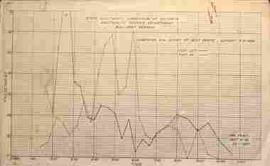 Ballarat Tramway Museum
Administrative record - Set of 18 Ballarat - Passenger graphs, State Electricity Commission of Victoria (SECV), 1956 - 1957
Set of 18 graphs showing route, date, passenger numbers by time: 1 - Gardens via Sturt St West - Sunday 5-2-1956 2 - Gardens via Drummond St North - Sunday 5-2-1956 3 - Victoria St - Sunday 5-2-1956 4 - Mt Pleasant - Sunday 5-2-1956 5 - Gardens via Sturt St West - Sunday 26-8-1956 6 - Gardens via Drummond St North - Sunday 26-8-1956 7 - Victoria St - Sunday 26-8-1956 8 - Mt Pleasant - Sunday 26-8-1956 9 - Lydiard St Nth - Sebastopol - Sunday - August 1956 10 - ditto - Feb. 1956 11 - Sunday Operation - average no. of passengers carried all routes, Sundays Nov. 1955 to Oct. 1956 12 - Sebastopol route - Sunday 6-1-1957 13 - Lydiard St Nth route - Sunday 6-1-1957 14 - Gardens via Sturt St West - Sunday 6-1-1957 15 - Gardens via Drummond St Nth - Sunday 6-1-57 16 - Victoria St - Sunday 6-1-1957 17 - Mt Pleasant - Sunday 6-1-1957 18 - Average Number of passengers per trip - Sunday 6-1-1957 Demonstrates the SECV Ballarat office work to understand Sunday passenger numbers. May have been part of a move to consider ceasing operations on Sundays.Printed graphs on foolscap paper set of 18.All have the SEC Drawing Office stamp and dated on the rear.tramways, statistics, passenger services, reports, ballarat, sunday services -
 Melbourne Tram Museum
Ephemera - Timetable, Melbourne & Metropolitan Tramways Board (MMTB), MMTB Tram timetables, set of 12, 1971
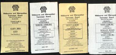
Timetables for specific routes, day of week giving information on tram times at specific time points, route map, sections and fares and organisation address - 616 Little Collins St. Melbourne. 1 - Glen Iris - City route 6 - Oct. 1971 2 - North Coburg with connecting bus to Fawkner and Gowrie - Upfield on Sundays - June 1971 3 - Mont Albert - City - routes 42, 44, 45, 37 - Oct. 1971 4 - West Coburg - Domain Road and West Coburg City on Sundays - routes 55, 56 and 68 - May 1971 5 - Essendon Aerodrome - City route 59 - June 1971 6 - East Brighton - City - routes 64, 65, 62, 61 - Oct. 1971 7 - Carnegie - City - routes 67, route 66 - Oct. 1971 8 - Wattle Park - City route 70, route 71 and route 76 - Oct. 1971 9 - Camberwell - City - route 72, route 73 - Oct. 1971 10 - Prahran - City, North Richmond -Prahran - St Kilda Beach, routes 77, 78 and 79 - Oct. 1971 11 - East Preston - City and East Brunswick - City - routes 88, 89, 90. 96 and 97 - Oct. 1971 12 - ditto for Sundays printed on green paper. 13 - Route 8, Toorak, Oct. 1971-*Yields information about 1971 MMTB timetables.Set of 12 1971 MMTB Tram timetables, folded sheets.trams, tramways, timetables, mont albert, route 42, route 6, route 19, upfield, route 44, route 45, route 37, route 55, route 56, route 68, route 59, route 64, route 65, route 62, route 61, route 67, route 66, route 70, route 71, route 76, route 72, route 73, route 77, route 78, route 79, route 88, route 90, route 96, route 97, route 8 -
 Ringwood and District Historical Society
Document - Department of Lands and Survey, Wire Netting Branch, Melbourne, Victoria, Application for Vermin-Proof Fence Certificate - L.J. Mills vs John Collins, Grandview Grove, Ringwood, Victoria - 1939
Photocopied file of corresponence and documentation relating to a claim by L.J. Mills, Nurseryman, that adjoining property owner, J. Collins, Farmer, assists with replacement of a vermin proof wire netting dividing fence destroyed by 1939 bushfire. File includes 1939 and 1940 detailed property inspection reports by Vermin and Noxious Weeds Branch, Lands Department, Lilydale, describing land use in the area and signs of vermin activity. Application approved 18th April, 1940. Appeal lodged by Mr Collins disallowed in May, 1940. File closed June, 1940 with Departmental suggesion that Mr Mills consider further legal action through a Solicitor as fence had still not been wire-netted. TRANSCRIPTS: Vermin & Noxious Weeds Inspection Reports "19/9/1939 (To) Superintendent (Department of Lands and Survey, Melbourne) Re L.J. Mills application for Vermin Proof Fence. I called on Mr Mills yesterday 18th instant in connection with this matter. Mr Mills has a flower farm and claims that rabbits and hares are damaging his flowers. He showed me a bed of carnations which he stated were being damaged by rabbits. There was evidence of some leaves being nipped off, but I am unable to say whether this is due to rabbits or grubs. Very little if any real damage is being done. The property is netted on the east and south boundary and on half the north and west boundary. The surrounding country is undlating and fairly steep in places. The land to the east across Grandview Avenue (sic) is all planted out in old established orchards and well cultivated. Cleared grass land adjoins the south boundary and bush land adjoins the north and west boundaries. I walked over a large area surrounding Mr Mills land and never saw any rabbits or hares or any indications of rabbits. This locality is not rabbit infested and very little wire netting is being used. I do not consider that a vermin proof fence is necessary between these allotments. - Jas H Allison (Inspector, Vermin and Noxious Weeds Branch, Lands Department, Lilydale)." Follow up report following renewal of application for Certificate by Mr Mills, citing rabbits causing considerable damage to his flowers. He laid poison and obtained 9 carcases and stated that there is evidence of rabbit infestation from the adjoing land. "19/3/1940 (To) Mr Hannah (Superintendant, Department of Lands and Survey, Melbourne) Re L.J. Mills, Grandview Grove Ringwood, Lot 4 Grandview Estate Pt CG20 Ph of Warrandyte. I interviewed Mr Mills at his home on 15th inst. He showed me carcases of rabbits which he stated had been poisoned on his land. In places young plants had been nipped off apparently by rabbits. I made an inspection of adjoining properties and found one live burrow close to Mr Mills northern boundary. There were scratches and other evidence of rabbits on land north and west of Mr Mills property. In view of the present evidence of rabbits I consider that a vermin proof fence is now necessary to protect the flowers grown by Mr Mills. His land is netted on whole of east and south boundary and half way on west and north boundary. The adjoining land on west and north boundaries is owned by Mrs Linda Collins and John Collins resp of Brysons Road East Ringwood. - Jas H Allison (Inspector, Vermin and Noxious Weeds Branch, Lands Department, Lilydale)." -
 Melbourne Tram Museum
Ephemera - Timetable/s, Public Transport Victoria (PTV), Timetable Notice giving details of temporary changes to service as part of the COVID 19, 2020
Timetable Notice giving details of temporary changes to service as part of the COVID 19 response where route 12 diverted by La Trobe St, and thus provided a service along Spencer St. Route 30 was suspended. Route 11A was introduced between Docklands and St Vincent's Plaza. htd4777i1.pdf shows a timetable alteration, reduction of services after 8pm, introduction of the 8pm to 5am curfew and stage four restrictions that were to apply (hopefully) for a six week period. Set of 23 digital timetables generally applicable from 10-11-2019 and two timetables for route 11 and12 applicable from 13 July. This change was a bit confusing at the time. Image files are htd4777iRx - x being the route number. Route 1 - East Coburg - South Melbourne Beach Route 3 and 3A - Melbourne University - East Malvern - and via St Kilda Beach - two timetables for each Route 5 - Melbourne University - Malvern Route 6 - Melbourne University - Glen Iris Route 11 - West Preston - Victoria Harbour Docklands Route 12 - Victoria Gardens - St Kilda Route 16 - Melbourne University - Kew Via St Kilda Route 19 - North Coburg - Flinders St Route 30 - St Vincent's Plaza - Etihad Stadium Docklands - though the stadium was renamed Marvel after Marvel comics by Disney during May 2018. Route 35 - City Circle - NOT Published. Route 48 - North Balwyn - Victoria Harbour Docklands Route 55 - West Coburg - Domain Interchange Route 57 - West Maribyrnong - Flinders St Route 58 - Toorak to Route 59 - Airport West - Flinders St Route 64 - East Brighton - Melbourne University Route 67 - Carnegie - Melbourne University Route 70 - Wattle Park - Waterfront City Docklands Route 72 - Camberwell - Melbourne University Route 75 - Vermont South - Etihad Stadium Docklands Route 78 - North Richmond - Balaclava via Prahran Route 82 - Footscray - Moonee Ponds Route 86 - Bundoora RMIT - Waterfront City Docklands Route 96 - East Brunswick - St Kilda Beach Route 109 - Box Hill - Port Melbournetrams, tramways, timetables, yarra trams, route 1, route 3, route 5, route 6, route 8, route 11, route 11a, route 12, route 16, route 19, route 30, route 48, route 55, route 57, route 58, route 59, route 64, route 67, route 70, route 72, route 75, route 78, route 82, route 86, route 96, route 109, covid-19, st vincent's plaza, spencer st -
 Melbourne Tram Museum
Ephemera - Timetable, Public Transport Corporation (PTC), Set of 24 The Met tram timetables, 1995
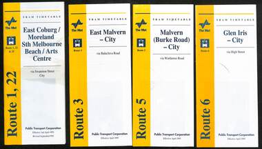
Set of 24 The Met Public Timetables.Demonstrates tram timetables published by The Met during 1995..1 - Printed 20 page book stapled timetable for East Coburg / Moreland Sth Melbourne Arts centre tram service, Route 1 and 22, dated April 1995. The "The Met" logo, was published by the Public Transport Corporation. Provides a map, description of route, time points, timetable, ticketing information, some ticketing information, introduction by the relevant Depot, including a photo - and an image of a tram available for hire as a party tram. .2 - Route 3 - East Malvern - City - April 1995 .3 - Route 5 - Malvern (Burke Road - City - April 1995 .4 - Route 6 - Glen Iris - City - April 1995 .5 - Route 8 - City - April 1995 .6 - Route 11 - City - April 1995 .7 - Route 11 - City - Nov. 1995 .8 - Route 12 - Sth Melbourne Beach and St Kilda Beach - City - April 1995 .9 - Route 16 - St Kilda Beach - City - April 1995 .10 - Route 19 - North Coburg - City - Nov 1994, revised 8/1995 .11 - Route 48 - North Balwyn - City - 30/4/1995, revised 9/1995 .12 - Route 64 - East Brighton - City - April 1995 .13 - Route 64 - East Brighton - City - Nov. 1995 .14 - Route 67 - Carnegie - City - April 1995 .15 - Route 67 - Carnegie - City - August 1995 .16 - Route 69 - Kew Cotham Road - St Kilda Beach - April 1995 .17 - Route 70 - Wattle Park - City - April 1995 .18 - Route 72 - Camberwell - City - April 1995 .19 - Route 75 - East Burwood - City - April 1995, revised 8/1995 .20 - Route 78/79 - North Richmond - St Kilda Beach or Prahran - April 1995 .21 - Route 86 - Bundoora - City - Oct 1995. .22 - Route 109 - Port Melbourne - Mont Albert April 1995 .23 - Route 109 - Port Melbourne - Mont Albert August 1995 .24 - La Trobe St Service - City - East Melbourne April 1995trams, tramways, tickets, the met, tram services, timetables, route 69, route 1, route 22, route 3, route 5, route 6, route 8, route 11, route 12, route 16, route 19, route 48, route 64, route 72, route 75, route 78, route 79, route 86, la trobe st - east melbourne, route 67, route 70, route 109 -
 Melbourne Tram Museum
Ephemera - Timetable, Melbourne & Metropolitan Tramways Board (MMTB), Set of 30 MMTB tram timetables, 1962
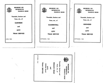
Demonstrates a set of MMTB 1962 timetables.Set of 30 MMTB tram timetables, folded sheets, 4 fold, providing timetables for specific routes, day of week giving information on tram times at the terminus, sections and fares, running times. Some signed by W. J. Richards as Acting Traffic Manager, or R. C. Drummond as Traffic Manager. Route Numbers not given on cover, generally given on inside. Where a All night service was applicable, shown as well. .1 - Burwood - City - 9/1962 .2 - Camberwell - City - 9/1962 .3 - Carnegie - City - 6/1962 .4 - Domain Rd - City - 10/1962 .5 - East Brighton - City - 6/1962 .6 - East Coburg - city - 9/1962 .7 - East Malvern - Darling Rd - City 27/5/1962 .8 - East Preston - City - 11/1962 .9 - Essendon Aerodrome - City - July 1962 .10 - Essendon (Matthews Ave) - City - 7/1962 .11 - Glen Iris - City - 8/1962 .12 - Hawthorn - Spencer St - 7/1962 .13 - Kew Cotham Rd - St Kilda Beach - 8/1962 .14 - Malvern Burke Rd - City - 8/1962 .15 - Mont Albert - City - 7/1962 .16 - Moreland - City - 9/1962 .17 - West Coburg - City 7/1962. .18 - North Balwyn - Spencer St - 7/1962 .19 - North Coburg - City - 6/1962 - has Sunday only Fawkner Railway station service on rear - 6/1962 .20 - North Richmond - Prahran and St Kilda Beach - 7/1962 .21 - Northcote (via St Georges Rd) - City - 7/1962 .22 - Prahran - City - 7/1962 .23 - South Melbourne and St Kilda Beach - City - 6/1962 .24 - St Kilda Beach - City - - 9/1962 .25 - Toorak - City - 8/1962 .26 - Wattle Park - Elgar Rd - City - 9/1962 .27 - West Maribyrnong - City - 7/1962 .28 - West Preston - City - 6/1962 .29 - West Coburg - City - 10/1962 ,30 - East Preston - City - 7/1962Some have "Robert Wilson" stamp on the covers.trams, tramways, timetables, tickets, fares, mmtb, all night services -
 Ringwood and District Historical Society
Newspaper, Scrapbook Clipping, Library Collection, Ringwood, Victoria
Newspaper Clipping from "The Post", Wednesday, August 4, 1993. "Bash attack on businessman"'.A local restaurateur and council candidate received abrasions and bruises after a vicious attack by two men at his pizza restaurant on Sunday morning. Joe Cassari, who is standing in Ringwood's North Ward was assaulted and the front window of his shop smashed after he asked two men to leave. Mr Cossari's nephew called the police immediately the fight started, but they had to call again 20 minutes later when they still hadn't arrived. The police said they had another job to go to. -
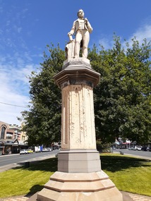 City of Ballarat
Sculpture - Public Artwork, George Grant, Thomas Moore Memorial Statue George Grant, 1889
Irish poet and balladeer Thomas Moore, best-known for penning The Minstrel Boy and The Last Rose of Summer, is honored in this statue prominently located in Sturt Street created by sculptor George Grant from white Carrara marble. George Grant was trained at the School of Art associated with the National Gallery of Victoria, apparently in the 1880s, and then worked as an artist, specialist house painter, and banner artist. Several of his paintings are held by the Ballarat Art Gallery. Moore`s writings range from lyric to satire, from prose romance to history and biography. His popular "Irish Melodies" appeared in ten parts between 1807 and 1835. Moore was a good musician and skillful writer of songs, which he set to Irish tunes, mainly of the 18th century. This statue is of historic and aesthetic significance to the people of Ballarat.Marble statue of Thomas Moore above a large sandstone pillar West: Presented to the City Council of Ballaarat by the following citizens: H.F. Elliot, The Honorable E. Morey M.L.C., Cr C.R. Retallick, Cr J. Heinz. South: R.S. Mitchell, P. Papenhagen, T. Elliot, J. Snow, G.K. Coutts, C. Bailey, J.J. Goller & Co, W.E. Ballhausen, G. Thompson, W.H. Figgis. North: S. Seward, F.G. Haymes, Craig Williamson, R. Giddings, G. Berry, R. Inge, J.A. Pittard, L. Lederman, H. Bremer, D. Jones. thomas moore -
 8th/13th Victorian Mounted Rifles Regimental Collection
Photograph - watering horses
See also 3089.86. Information with that photo gives an alternative provenance: 8th Light Horse Regiment watering horses at a Murray River lagoon, South Corowa NSW, September 1939; Wahgunyah Troop, C Squadron - this side of lagoon, Lieutenant J. Nott on grey horse in water. The number of horsemen would seem to exceed that of a single regiment so the Torquay description would seem more probable.Black and white photograph ( laminated ) of 8th, 13th,20th, and 4thLight Horse Regiments watering horses near Torquay Victoria , March 1940.Picture taken about March 1940 when the 13th Light Horse from Gippsland, the 8th Light Horse from Upper Murray, the 4th Light Horse from the Western Districts and the 20th Light Horse from the Goulburn Valley were in camp near Torquay. Mr Cappur Webb of Glendoxey, Seymour, a member of the 20th said the picture must have been taken during an exercise about five miles north of Torquay. “We used to water our horses in that lake”, he said." light horse, torquay, wwii, world war two, military, horses -
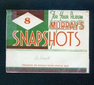 Orbost & District Historical Society
photographs, Murray Studio, Murray Views, 1940's 1950's
This collection of photographs produced by Murray Views, Gympie, features eight scenic black / white photographic prints of Orbost and surrounding tourist areas.Photographs like these allowed tourists to send many images of their holiday destination or hometown in the one small package. Fred Murray opened Murray Studios in Gympie in 1906. The postcard and souvenir production side of the business initially covered Gympie and surrounding regions, but Murray expanded the business to include North Queensland, NSW and even Adelaide. It was opened under a separate name, Murray Views, in 1929. In 1945 the business was taken over by Murray’s nephews who began postcard folder production.These photographs are a useful research material.A white envelope with green and white print containing eight photographs of the Orbost area. It is titled For Your Album Murray's Snapshotssouvenir photographs-orbost postcards -
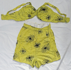 Orbost & District Historical Society
playsuit, Burton, Marjorie, 1950's
This item was worn by Marjorie Burton during summer holidays in Croyde,a village on the west-facing coastline of North Devon, England. Marjorie Burton ( nee Whiteman), born 12 June, in Birmingham, England came to Orbost in 1995. In England she did office work – typing, shorthand and secretarial work - in accountants’ offices and also trained as a comptometrist with Burroughs in London. She came from middle-class working church-going family. Her mother was a milliner who made mostl of Marjorie’s clothes, hats and outfits. Marjorie was married in 1938 to a salesman who later became a mechanic in the R.A.F. during WW11. Also called a vintage romper today, the playsuit was a cover-up worn outdoors – either at the beach, in the backyard to catch some sun or for sportswear, generally over swimsuits at the beach or pool, They were so comfortable women often wore them at home too, without swimsuits. Playsuits were usually made of cotton, although they could also be found in rayon. They were brightly colored, in reds, greens, yellows and blues. Floral and Hawaiian prints were popular towards the end of the decade. This item is an example of an item of women's clothing popular in the mid 20th century. A two piece lady's playsuit. It is yellow with black patterns - stylised flowers . The top is a bra top with a hook and eye closing. The shorts have a zip at the back and close with a hook and eye, There is a white band at the top.playsuit women's-clothing burton-marjorie -
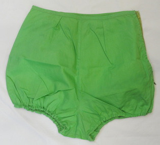
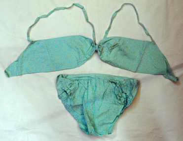 Orbost & District Historical Society
bikini, Burton, Marjorie, mid 1950's
This item was worn by Marjorie Burton during summer holidays in Croyde,a village on the west-facing coastline of North Devon, England. In England she did office work – typing, shorthand and secretarial work - in accountants’ offices and also trained as a comptometrist with Burroughs in London. She came from middle-class working church-going family. Her mother was a milliner who made many of Marjorie’s clothes, hats and outfits. Marjorie married in 1938 to a salesman who later became a mechanic in the R.A.F. during WW11. Marjorie Burton ( nee Whiteman), born 12 June, in Birmingham, England came to Orbost in 1995. This item is an example of a handcrafted item and reflects the handcraft skills of women during the mid 20th century.A pale hand-stitched torquoise coloured cotton bikini set. The bottoms are briefs and elasticated at the front. They have high rise leg openings . The top is a bra style with a strap pinned at the centre of the back with a gold safety pin and stitched at the shoulders to loop over. There are 2 hooks and eyes for closure.women's-clothing swimwear burton-marjorie -
 Orbost & District Historical Society
bloomers, Burton, Marjorie, mid 1950's
This item was made and worn by Marjorie Burton. This item was wornduring summer holidays in Croyde,a village on the west-facing coastline of North Devon, England. Marjorie Burton ( nee Whiteman), born 12 June, in Birmingham, England came to Orbost in 1995. In England she did office work – typing, shorthand and secretarial work - in accountants’ offices and also trained as a comptometrist with Burroughs in London. She came from middle-class working church-going family. Her mother was a milliner who mademanyof Marjorie’s clothes, hats and outfits. Marjorie married in 1938 to a salesman who later became a mechanic in the R.A.F. during WW11This item is an example of ahome-madepiece of clothing and reflects the needlework skills of women in the mid twentieth century.A pair of lime green cotton bloomers - home-made. They faste with a zip on the right-hand side. They are probably part of a set meant to wear with a bikini bra top.bloomers women's-clothing swimwear burton-marjorie -
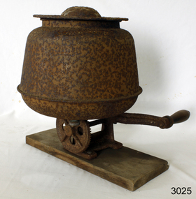 Flagstaff Hill Maritime Museum and Village
Domestic object - Butter Churn, Malleys Ltd, 1930-1950
This is a steel, bench-mounted, hand-operated (60 rpm) butter churn for making small amounts of butter from cream in the home. It was made by the Sydney firm of Malleys Ltd from the 1930s until the 1950s and came in 3 and 5 quart sizes. Malleys Ltd was established in about 1890 by Francis Malley (1863-1932). This firm was located in the Sydney suburb of Alexandria, in McEvoy Street. They manufactured items for use in the dairy industry, as well as for hardware related to building and plumbing. Many of the Malley dairy products were sold under the "Sunrise" name. Malley retired in 1912. In 1931 there were branches at Parramatta, Hurstville & North Sydney. Butter churns were machines used to produce butter by the violent agitation of separated cream. Depending on the design of the churn, the agitation would be variously achieved by a repetitive thrashing, centrifugal motion or internal paddles. Churns were typically constructed from wood, glass and cast-iron; with tin or steel commonly used for some fixtures. The subject item gives an insight into domestic life where butter was made in the home.Heavy red cast iron base, with a long handle, wooden grip, connected to a shaft along the base, thence, to a cog wheel, and gear, to a second shaft and paddle in a metal basin. Basin has lid, and hole in base with a screw cap to allow the draining of the butter milk. Designed to be placed on a bench, with the handle over the edge. Malleys is written in raised letters on the base, and on the handle, '60 rev. pr. min.'warrnambool, flagstaff-hill, flagstaff-hill-maritime-museum, shipwreck-coast, flagstaff-hill-maritime-village, malleys, butter churn, domestic object, dairy machine -
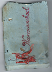 Warrnambool and District Historical Society Inc.
Album - Album, photograph Warrnambool Horn Esq
This album contains photographs of a family, (the Horns of ‘Wildwood’, Warrnambool) and other photographs of Warrnambool – the foreshore, the Soldiers’ Memorial, the Breakwater, the Hopkins River, Liebig and Timor Streets etc. It has been made by a member of the Horn family and given as a Christmas present to other members of the family. Charles James Horn came to Australia in 1881and was a tutor to the Barber family of ‘Staywood Park’, Wangoom. He and his wife Emma then worked a property at Cudgee before settling in Warrnambool at ‘Wildwood’ in North Warrnambool. One of their sons, Charles Bernard Horn married Margaret Cairns in 1916 but died in 1927. Another son, Leslie, was killed in World War One. This little album is of great interest because it contains photographs of the Horn family and other photographs of views in Warrnambool. It is therefore of considerable historical interest and will be very useful to researchers. As it is a handmade item it is also of interest because it is an example of the sort of homemade items made as presents at a time (the late 1920s) when finances for something more expensive may not have been available. These are two items which are believed to be linked. One is an envelope marked ‘C.J. Horn, Wildwood, Warrnambool’ and the other is a blue-covered homemade album of photographs bound with red wool. The front cover has ‘Warrnambool’ written in red ink and the back of the front cover is stamped ‘Ralph Barnes, Chemist, Warrnambool’. There are 22 sepia-coloured photographs of a family (the Horns) and other views of Warrnambool. All have a label on the back. The back page of the cover has an advertisement for ‘Seltona’ self-toning paper.‘Warrnambool’ ‘7 sheets glossy Seltona’ collodion self-toning paper containing gold, Sole Manufacturers, Wellington and Ward, Elstree, Herts.’ ‘From us both to you both, Wishing you a Happy Christmas and a Glad New Year’. warrnambool, horn family, charles james horn, staywood park, wildwood warrnambool -
 Eltham District Historical Society Inc
Photograph - Aerial Photograph, Landata, Eltham / Research, Vic, Jan. 1951
Centred on Brinkkotter Road opposite Yarramie Reserve, Eltham bounded by Maroondah Aqueduct to north, Nyora Road to south, Eltham College to east and Leane Drive to west. Historic Aerial Imagery Source: Landata.vic.gov.au Aerial Photo Details: Project No :65 Project : MELBOURNE AND METROPOLITAN PROJECT NO. 2 Run : 7 Frame : 8 Date : 01/1951 Film Type : B/W Camera : EAG9 Flying Height : 12200 Scale : 12000 Film Number : 1419 GDA2020 : 37°42'32"S, 145°10'41"E MGA2020 : 339408, 5824924 (55) Melways : 22 F3 (ed. 42)Historical aerial photos and photo maps provide viusal evidence of the chronology of changes to the built landscape of the district and assist in dating other imagesaerial photo, 1951-01, eltham, neil webster collection, brinkkotter road, eltham college, leane drive, maroondah aqueduct, melways 22f3, nyora road, yarramie reserve -
 Eltham District Historical Society Inc
Photograph - Aerial Photograph, Landata, Eltham, Vic, Jan. 1951
Centred on Beard Street between Main Road and Frank Street, Eltham bounded by Maroondah Aqueduct to north, Arthur Street to south, Maroong Drive to east and Catholic Ladies College to west. Historic Aerial Imagery Source: Landata.vic.gov.au Aerial Photo Details: Project No :65 Project : MELBOURNE AND METROPOLITAN PROJECT NO. 2 Run : 7 Frame : 9 Date : 01/1951 Film Type : B/W Camera : EAG9 Flying Height : 12200 Scale : 12000 Film Number : 1419 GDA2020 : 37°42'23"S, 145°09'39"E MGA2020 : 337874, 5825170 (55) Melways : 22 B3 (ed. 42)Historical aerial photos and photo maps provide viusal evidence of the chronology of changes to the built landscape of the district and assist in dating other imagesaerial photo, 1951-01, eltham, neil webster collection, arthur street, beard street, catholic ladies college, frank street, main road, maroondah aqueduct, maroong drive, melway 22b3, research (vic.) -
 Eltham District Historical Society Inc
Photograph - Aerial Photograph, Landata, Montmorency, Feb. 1956
Centred on present day Tahlee Place Reserve and Sherbourne Preschool, Montmorency bounded by Progress Road to north, Withers Way to south, Main Road to east and Leach Street to west. Historic Aerial Imagery Source: Landata.vic.gov.au Aerial Photo Details: Project No :250 Project : MELBOURNE OUTER SUBURBS PROJECT Run : 17 Frame : 114 Date : 02/1956 Film Type : B/W Camera : EAG9 Flying Height : 10000 Scale : 12000 Film Number : 1176 GDA2020 : 37°42'50"S, 145°08'02"E MGA2020 : 335512, 5824286 (55) Melways : 21 F5 (ed. 42)aerial photo, 1956-02, neil webster collection, central park, eltham, leach street, main road, melway 21f5, montmorency, progress road, withers way, sherbourne preschool, tahlee place reserve -
 Eltham District Historical Society Inc
Photograph - Aerial Photograph, Landata, Lower Plenty, Feb. 1956
Centred on present day 217 Old Eltham Road, Lower Plenty bounded by Pitt Street to north, Yarra River to south, Main Road to east and Bonds Road to west. Historic Aerial Imagery Source: Landata.vic.gov.au Aerial Photo Details: Project No :250 Project : MELBOURNE OUTER SUBURBS PROJECT Run : 17 Frame : 116 Date : 02/1956 Film Type : B/W Camera : EAG9 Flying Height : 10000 Scale : 12000 Film Number : 1176 GDA2020 : 37°43'58"S, 145°07'49"E MGA2020 : 335237, 5822186 (55) Melways : 21 E10 (ed. 42)aerial photo, 1956-02, neil webster collection, eltham, main road, bonds road, elham, lower plenty, melway 21e10, pitt street, yarra river -
 Eltham District Historical Society Inc
Photograph - Aerial Photograph, Landata, Eltham, Feb. 1956
Centred on present day Shalbury Avenue, Eltham bounded by Leane Drive and Parsons Road to north, Nyora Road to south, Reynolds Road to east and the Diamond Creek to west Historic Aerial Imagery Source: Landata.vic.gov.au Aerial Photo Details: Project No :250 Project : MELBOURNE OUTER SUBURBS PROJECT Run : 18 Frame : 95 Date : 02/1956 Film Type : B/W Camera : EAG9 Flying Height : 10000 Scale : 12000 Film Number : 1176 GDA2020 : 37°41'57"S, 145°09'51"E MGA2020 : 338145, 5825965 (55) Melways : 22 C1 (ed. 42)aerial photo, 1956-02, neil webster collection, eltham, diamond creek (creek), melway 22c1, nyora road, parsons road, reynolds road, shalbury avenue -
 Eltham District Historical Society Inc
Photograph - Aerial Photograph, Landata, Research, Vic, Feb. 1956
Centred on present day Thompson Crescent, Research bounded by Maroondah Aqueduct to north, Thompson Crescent and Nyora Road to south, Bells Hill Road to east and Eucalyptus Road to west Historic Aerial Imagery Source: Landata.vic.gov.au Aerial Photo Details: Project No :250 Project : MELBOURNE OUTER SUBURBS PROJECT Run : 19 Frame : 6 Date : 02/1956 Film Type : B/W Camera : EAG9 Flying Height : 10000 Scale : 12000 Film Number : 1176 GDA2020 : 37°42'38"S, 145°11'02"E MGA2020 : 339927, 5824736 (55) Melways : 22 H4 (ed. 42)aerial photo, 1956-02, neil webster collection, bells hill road, eltham, eucalyptus road, maroondah aqueduct, melway 22h4, nyora road, research (vic.), thompson crescent