Showing 3677 items
matching gold mining
-
 Rutherglen Historical Society
Image, 1931
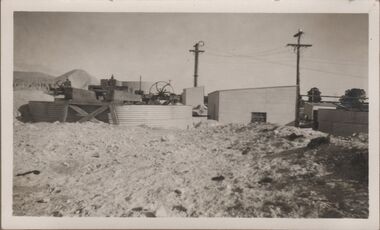
... gold mining... of separating gold from the ore. great southern gold mining gold ...Photographs showing the works at the Great Southern Mine, cyanide plant, which was an important part of the process of separating gold from the ore.One of 4 small black and white photographs, mounted on a single album page. This one shows buildings, tanks and equipment of the plant.Written on album page between photos: "Great Southern Mine Cyanide Plant 1931"great southern, gold mining, gold processing, cyanide plant -
 Rutherglen Historical Society
Image, 1931
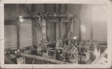
... gold mining... of separating gold from the ore. great southern gold mining gold ...Photographs showing the works at the Great Southern Mine, cyanide plant, which was an important part of the process of separating gold from the ore.One of 4 small black and white photographs, mounted on a single album page. This one shows three pumps in a corrugated iron building.Written on album page between photos: "Great Southern Mine Cyanide Plant 1931"great southern, gold mining, gold processing, cyanide plant -
 Unions Ballarat
Book - Letters from a miner in Australia
... gold mining.... Autobiographical interest. gold mining gold rush fauchery antoine btlc ...An account of Melbourne and the Victorian goldfields during the 1950s gold rush. The book includes experiences as a miner, as a storekeeper in the goldfields and, briefly, as owner of a French cafe in Melbourne.Hardback with dustjacket; yellow background; black lettering; 105 pages. An account of Melbourne and the Victorian goldfields during the 1950s gold rush. The book includes experiences as a miner, as a storekeeper in the goldfields and, briefly, as owner of a French cafe in Melbourne.gold mining, gold rush, fauchery antoine, btlc, ballarat trades and labour council, correspondence, australian history-1950s, ballarat, photography, travel -
 Bendigo Historical Society Inc.
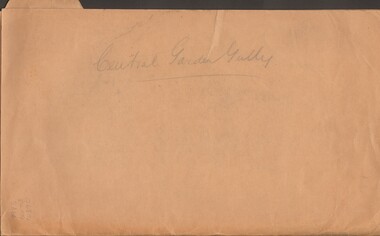
Document - MCCOLL, RANKIN AND STANISTREET COLLECTION: CENTRAL GARDEN GULLY
... GOLD MINING... MINING Miners' Safety Cage Central Garden Gully Mining Gold Mines ...Manilla Folder containing correspondence and applications for a mining lease on the Garden Gully Line known as Mumford's Claim, also contains maps of lease numbers 9993, 10173, and 10390 (all on the Garden Gully Line).McColl Rankin & Stanistreet, Charing Cross Bendigogold mining, miners' safety cage, central garden gully, mining, gold mines, bendigo, garden gully, mumfords claim -
 Buninyong Visitor Information Centre
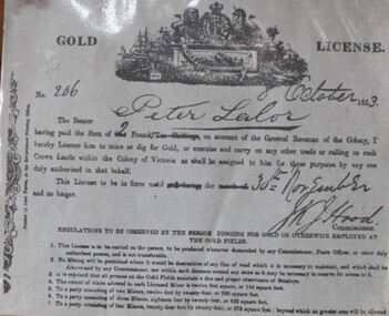
Document - License, Ballarat Historical Society, Gold License
... Gold Mining... Buninyong goldfields Eureka Stockade Peter Lalor Gold Mining Gold ...Reproduction of a gold license issued to Peter Lalor on 8 October 1853, No. 206 Published by the Ballarat Historical Society in the 1970s. Has historical notes on reverse side.eureka stockade, peter lalor, gold mining, gold rush, gold licences -
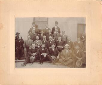 Bendigo Historical Society Inc.
Photograph - OPENING OF CENTRAL RED, WHITE AND BLUE BATTERY, 13th March, 1912
... Gold mining... White and Blue Gold Mine Bendigo Gold mining gold W.H. Robinson ...The Central Red, White and Blue Gold Mine was registered on 30th October, 1891. William Weeks Barker was the Manager. Thirty thousand shares at 2/- each were issued. (Government Gazettes online: https://gazette.slv.vic.gov.au/view.cgi?year=1891&class=general&page_num=4465&state=V&classNum=G138&searchCode=8733417) It's place of operation is given as Bendigo. Black and white photograph with sepia toning. Posed group of twenty four males. Mine building in background (Central Red, White and Blue?). Opening of mine. Inscriptions: on back - ink stamp 'W.H Robinson, Photographer, Mundy Street, Bendigo'. Separate paper insert : identified by James Lerk, 6/3/2000. (17/24 gents identified). Heading 'Opening of the Central Red, White and Blue Battery, Wednesday 13th March 1912'. Top Row: A.H. Merrin Chief Inspector of Mines, R.T. Trembath Chairman of the Stock Exchange, J.R. Clark. Second row: A.A. Samuels, P. Jorgensen, G. Kingsley Mine Manager, J.J. Stanistreet Legal Manager, W.H. Cundy Geologist. Third row: T. Jorgensen Engineer (man with moustache), Councillor H.A.Ross Mayor, W.Keck Chairman Of Directors, P. McBride Minister of Mines, W. Casley, A. Gard. Front row: Senator J.H. McColl Legal Manager, R.A. Rankin Legal Manager, E.G. Mueller, G. Lansell?…W.H. Robinson, Mundy Street Bendigo.central red white and blue gold mine, bendigo, gold mining, gold, -
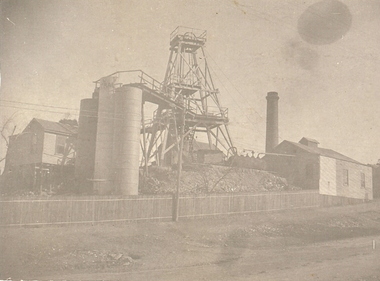 Bendigo Historical Society Inc.
Photograph - CENTRAL RED WHITE AND BLUE MINE
... gold mining... gold mining gold Central Red White and Blue Gold Mine Chum ...The Central Red White and Blue Gold Mine was Bendigo's leading gold mine from 1910 - 1913. During the mine's operation, the main shaft was sunk 670 metres, and retrieved over 2500KG of gold. The Central Red White and Blue Gold Mine was located on the corner of Chum St and Honeysuckle St in Golden Square.black and white photo - poppet legs, corrugated iron buildings, round brick chimney stack, 3 cylindrical metal tanks, picket fence across from left to RH side of building, Electricity pole at centre..bendigo, gold mining, gold, central red white and blue gold mine, chum street, honeysuckle -
 The Beechworth Burke Museum
Photograph, 1910
... gold mining... founded his gold and tin mining company which ran successfully... founded his gold and tin mining company which ran successfully ...This photograph dating to 1910 depicts an open cut sluicing site located in El Dorado captured looking east up the open cut from the number 3 Barge site. Sluicing was undertaken in the area from 1900 to 1942 with some short breaks between these periods. The image depicts a location mined by Cocks Pioneer Gold and Tin Sluicing Company (as recorded on the annotation on the card mount). It portrays open cut rocks with a crevice in the center of the image where the sluicing was being undertaken. There is a small timber structure on the right of the image which could be an entrance to a mine or supports made of wood to prevent a cave in at the open cut site and above the cut rock there is bush. The timber structure has rail tracks on top of the bridge which could suggest the identification of this structure as a mine entrance. The rail tracks were used for little carts which hauled soil from the mine. The Cocks Pioneer Gold and Tin Mines N.L was one of El Dorado's two largest open cut sluicing mines of the 20th Century. The other was named the Cocks El Dorado Gold Dredging Company. The Cocks Pioneer Mines operated from 1901 until 1941 and found a total of 117,378 ounces of Gold and 1,673 tones of tin concentrates over these years. The Cocks company was formed in 1898 and operated until 1941. Open cut sluicing involved the use of high-powered hoses which used the centrifugal sand pump system (known as hydraulic sluicing) which broke down the soil which was then processed for gold and other precious metals. From 1914 , four years after this image was captured, the company reformed to Cocks Pioneer Gold and Tin Mines NL (previously it was known as Cocks Pioneer Sluicing Co) and undertook large scale sluicing operations until 1929 and then 1934-1941. El Dorado is located on Reedy Creek and is surrounded by forested country to the north and east. It is 20 km east of Wangaratta in Victoria's regional north-east. John Cock was the son of a Cornish minor who arrived in El Dorado in 1858. Cock founded his gold and tin mining company which ran successfully for many years in the El Dorado region. It was an open cut sluicing company because of the abandonment of underground mining after this was deemed too dangerous. In 1935 Cock's El Dorado Company commissioned the floating dredge which is still visible in El Dorado today. The dredge was built by the Thompson engineering works, Castlemaine, and weighed over 2,000 tones and today has a place on the Victorian Registers of historic buildings. Interestingly, the name El Dorado does not derive from the gold in the region, but from the Barambogie pastoral run completed by William Baker in 1840-1841. Gold was discovered in El Dorado 1854 but the gold was too deep for individual prospectors to find, it required the use of heavy machinery.The search for gold is ingrained into the history of Victoria and therefore, images like this one which portray an open cut sluicing site can reveal important information for society and technology for the date when the photograph was taken. This image is of important historical significance for its ability to convey information about sluicing and the methods used to find gold in 1910. It also shows a location where sluicing was undertook which provides insight into the impact of sluicing on the environment at a time when it was done. This image is important for current research into the history of El Dorado, a small regional location near Wangaratta in Victoria's North East. Therefore, this image has the capacity to be beneficial for research into society and the motivations of those living and working in this region during this period and therefore, has social significance. The Beechworth Burke Museum has additional images relating to gold sluicing and El Dorado which can be analysed and studied alongside images like this one.Sepia coloured rectangular photograph printed on gloss photographic paper mounted on board.Obverse: COCKS PIONEER Q + T SL CO, N.L. / 1910 / LOOKING EAST UP OPEN CUT / FROM NO3 BARGE SITE / Reverse: 1997 . 2611 / A02611el dorado, north east gold, sluicing, gold sluicing, hydraulic sluicing, 1910, gold and tin mine, open cut mining, mining, gold mining, north-east victoria, beechworth, burke museum -
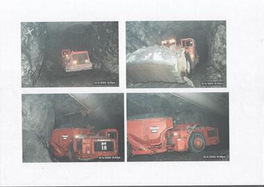 Bendigo Historical Society Inc.
Photograph - Kangaroo Flat Gold Mine Collection: underground mining machinery, 21st May 1999
... Kangaroo Flat Gold Mine Collection: underground mining.... Photograph Kangaroo Flat Gold Mine Collection: underground mining ...Colour photocopy of original photo. Four separate images showing underground mining machinery working in the Swan Decline, Kangaroo Flat Gold Mine. On one machine (bottom LH corner) 'Tamrock DT 18' visible on side of equipment. Date stamp on all four images is 12/6/2000, between times of 12.35 p.m. to 12.48 p.m.western mining corporation, goldmining, capping, shaft, mining regulations, kangaroo flat gold mine, 2000, swan decline, machinery -
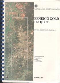 Bendigo Historical Society Inc.
Booklet - Kangaroo Flat Gold Mine Collection: Western Mining Corporation Bendigo Gold Project Environmental Effects Statement December 1987, Western Mining Corporation, Bendigo Office, Western Mining Corporation Limited Bendigo Gold Project Environment Effect Statement December 1987, December 1987
... Kangaroo Flat Gold Mine Collection: Western Mining...Western Mining Corporation Limited Bendigo Gold Project..., On front cover: Western Mining Corporation Bendigo Gold Project... Kangaroo Flat Gold Mine Collection: Western Mining Corporation ...Spiral bound booklet, plastic cover, black plastic binding, On front cover: Western Mining Corporation Bendigo Gold Project, Environment Effects Statement, December 1987. On front page, colour aerial photograph of Bendigo mining areas mentioned in report. Key on front page related to photograph: 1. Woodvale Evaporation Ponds. 2. New Moon area. 3. North New Chum Williams United shaft. 4. Carshalton, Carshalton shaft. 5. South Nell Gwynne, North Bendigo shaft. Contents: historical perspective; Western Mining Corporation Ltd Bendigo activities; project outline, project approvals - controlling factors, elements of the mining project, surface based exploration, underground operations and surface support, mining areas and operations ore and mullock haulage, New Moon area, water management, environmental management. Planning and land use, socio-economic environment, physical environment and biological environment are examined and discussed. bendigo, goldmining, bendigo mining nl, bendigo goldfield, environmental effects statement, bendigo gold project, woodvale evaporation ponds, new moon, north new chum, carshalton, south nell gwynne, western mining corporation -
 Bendigo Historical Society Inc.
Booklet - Kangaroo Flat Gold Mine Collection: Bendigo Mining NL Decline Ground Conditions and review of Boxcut, May 1998
... Kangaroo Flat Gold Mine Collection: Bendigo Mining NL... Gold Mine Collection: Bendigo Mining NL Decline Ground ...Spiral bound booklet, plastic cover, blue binding (copy of original)blue back page cover. Thirty four page report 'assesses ground conditions, mining advance rates and support requirements in the weathered zone of the proposed Bendigo decline'. Summary of contents: Bendigo rock mass; boxcut; portal development; decline development (weathered zone); structural domains; rock property data; rock mass classification; portal excavation and support requirements; decline in the weathered zone; shotcreting and boxcut design. western mining corporation, bendigo, goldmining, williams united, northern boxcut, decline, bendigo mining nl, geotechnical, rock mass, rock classifications, bendigo rock mass, shotcreting, rockbolts -
 Bendigo Historical Society Inc.
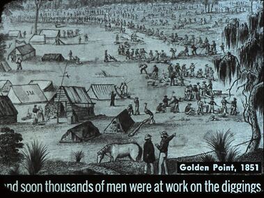
Slide - DIGGERS & MINING. THE GOLD ERA, c1851
... DIGGERS & MINING. THE GOLD ERA... DIGGERS & MINING. THE GOLD ERA ...BHS CollectionDiggers & mining. And soon thousands of men were at work on the diggings. Slide shows the diggings at Golden Point,1851. The gold era. Markings 5 994.031 GOL:5. Used as a teaching aid.hanimounteducation, tertiary, goldfields -
Clunes Museum
Newspaper - NEWSPAPER CUTTING, THE MELBOURNE AGE, GEESE, GOATS AND GIRLS IN OLD CLUNES, 4 SEPTEMBER 1965
... GHOST TOWNS AND GOLD MINING...GHOST TOWNS AND GOLD MINING CLUNES HISTORY MINING GHOST ...GHOST TOWNS AND GOLD MININGNEWSPAPER CUTTING. THE AGE LITERARY REVIEW SEPTEMBER 4, 1965. TAKEN FROM GHOST TOWNS OF AUSTRALIA BY GEORGE FARWELLclunes, history, mining, ghost towns, george farwell -
Lakes Entrance Regional Historical Society (operating as Lakes Entrance History Centre & Museum)
Photograph, 1914
... Black and white photograph of old gold mining town between... photograph of old gold mining town between Swifts Creek and Omeo ...Black and white photograph of old gold mining town between Swifts Creek and Omeo, Cassilis Victoriaaccommodation, hotels, bridges -
 Eltham District Historical Society Inc
Photograph - Digital Photograph, Marguerite Marshall, One Tree Hill Mine, Smiths Gully, 8 June 2006
... Gold mining... resumed mining One Tree Hill in 1998. As late as the 1920s gold... resumed mining One Tree Hill in 1998. As late as the 1920s gold ...Gold was discovered on One Tree Hill in 1854. The site has been worked intermittently until fairly recent times. Published: Nillumbik Now and Then / Marguerite Marshall 2008; photographs Alan King with Marguerite Marshall.; p53 Though still a working mine, One Tree Hill Mine at Smiths Gully, now stands in a tranquil reserve surrounded by bush and native animals - in contrast to its heyday. In the mid 19th century, when the mine was part of the Caledonia Goldfields, hundreds of men in search of their fortune worked the alluvial gold in the Yarra River, its tributaries and the reefs that made up the goldfields. Miner Stan Bone, assisted by Wilfred Haywood, is the last of the independent gold miners in the area and still uses the quartz crushing battery as miners did when gold was first discovered in the area in 1851.1 Stan, who is the last of six generations of miners in his family, was aged 17 when he began mining on his father Alex’ mine, The Golden Crown in Yarrambat. These days, after blasting the gold-bearing rock in Mystery Reef, one of the four reefs at One Tree Hill, Stan transports it around five kilometres by tip truck to the Black Cameron Mine for crushing. There he uses water from the waterlogged mine, (which still contains gold), as the Happy Valley Creek at One Tree Hill is usually dry.2 The One Tree Hill Mine has been worked for close to a century since it opened around the late 1850s.3 The Swedish Reef was its most productive reef and one of the largest in the area. Around 1859, extractions included 204 ounces (5.8kg) of gold, won from 57 pounds (26kg) of stone.4 Then during World War Two, Stan’s uncle, Bill Wallace, and Alex Bone, closed the mine. In 1973, Stan, with his Uncle Bill, reopened the Black Cameron Mine and worked there until 1988. Stan resumed mining One Tree Hill in 1998. As late as the 1920s gold was picked up by chance! When crossing a gully on his way to vote at the St Andrews Primary School, Bill Joyce picked up some quartz containing gold. This site was to become the Black Cameron Mine. The Caledonia Diggings, named after Scotland’s ancient name by local Scots, began around Market Square (now Smiths Gully) and included Queenstown (St Andrews), Kingstown (Panton Hill) and Diamond Creek. There were also poorer bearing fields in Kangaroo Ground and Swipers Gully (now Research). * None of these compared in riches to the Ballarat and Bendigo fields5, but the Caledonia Diggings continued intermittently for close to 100 years. Gold was discovered in Victoria following a bid to stem the disappearance of much needed workmen to the New South Wales diggings. Several businessmen offered a reward of £200, for the discovery of gold within 200 miles (322 km) of Melbourne. Late in June 1851, gold was first discovered at Andersons Creek, Warrandyte. Then in 1854, George Boston and two other men discovered gold at Smiths Gully. Gold transformed the quiet districts, with a constant flow of families and vehicles on the dirt tracks en route to the Caledonia Diggings. Three thousand people worked the gullies in Market Square, including about 1000 Chinese miners. The square established its own police, mining warden, gold battery, school, shops and cemetery and grog flowed. Market Square flourished until the middle 1860s. Bullocks transported quartz from the Caledonia Goldfields to the crushing machinery at the Queenstown/St Andrews Battery, near Smiths Gully Cemetery. It was destroyed by bushfire in 1962. By the late 1850s, most early alluvial fields were in decline, but minor rushes continued until around 1900 and some until the early 1940s. Some miners did well, although most earned little from their hard labour in the harsh and primitive conditions.6 But according to historian, Mick Woiwod, the gold fields helped to democratise society, as individuals from all walks of life were forced to share experiences, and the ability to succeed, depended less on inherited wealth or social rank.This collection of almost 130 photos about places and people within the Shire of Nillumbik, an urban and rural municipality in Melbourne's north, contributes to an understanding of the history of the Shire. Published in 2008 immediately prior to the Black Saturday bushfires of February 7, 2009, it documents sites that were impacted, and in some cases destroyed by the fires. It includes photographs taken especially for the publication, creating a unique time capsule representing the Shire in the early 21st century. It remains the most recent comprehenesive publication devoted to the Shire's history connecting local residents to the past. nillumbik now and then (marshall-king) collection, gold mining, one tree hill mine, smiths gully -
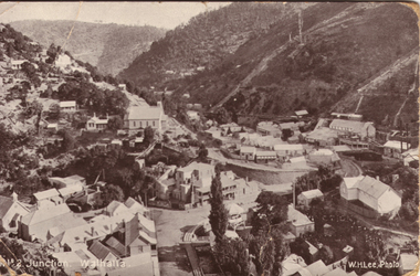 Victorian Interpretive Projects Inc.
Postcard, Junction Walhalla, Victoria
... Walhalla is a gold mining town in Victoria...., 3350 goldfields Walhalla is a gold mining town in Victoria ...Walhalla is a gold mining town in Victoria.Photograph of a postcard showing the Victorian township of Walhalla. wallhalla -
 Stawell Historical Society Inc
Photograph, "Wonga" Gold Mine 1903
... Wonga Mine Gold Mining 1903... grampians Wonga Mine Gold Mining 1903 Stawell Mining "Wonga" Gold ...Wonga Mine Gold Mining 1903stawell mining -
Clunes Museum
Tool - GOUGE
... THE GOUGE WAS USED AS A GOLD MINING TOOL... WAS USED AS A GOLD MINING TOOL LOCAL HISTORY TOOL TRADES SHIPWRIGHT ...THE GOUGE WAS USED AS A GOLD MINING TOOLA GOUGE - A CHISEL WHOSE BLADE IS CURVED. LONG SHAFT WITH CURVED BLADE AND T-BAR HANDLE local history, tool, trades, shipwright, laurie dilks -
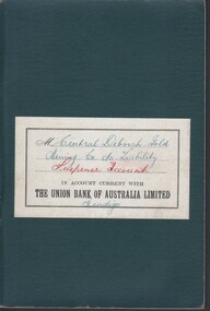
 Bendigo Historical Society Inc.
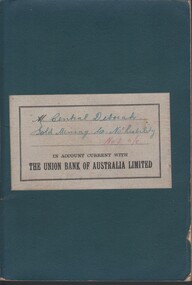
Document - MCCOLL, RANKIN AND STANISTREET COLLECTION:CENTRAL DEBORAH GOLD MINE, 1949-50
... 'Bank Account Book for Central Deborah Gold Mining Co. from... 'Bank Account Book for Central Deborah Gold Mining Co. from ...'Bank Account Book for Central Deborah Gold Mining Co. from McColl,Rankin & Stanistreet-Legal Managers & Accountants Bendigo'. Printed on label 'IN ACCOUNT CURRENT WITH THE UNION BANK OF AUSTRALIA LIMITED'. Hand writing 'Central Deborah Gold Mining Co. No. liabilty No.1 a/c.The Union Bank Of Australiadocument, gold, central deborah gold mine, central deborah gold mine, gold mine, gold, mine, mccoll rankin & stanistreet, the union bank of australia, bendigo, business records. -
 Bendigo Historical Society Inc.
Document - MCCOLL, RANKIN AND STANISTREET COLLECTION: NEW SOUTH MOON MINE - BATTERY PLANT, 1942
... to be installed.east Clarence Gold Mining Co. North Virginia Gold Mining Co. re... where battery to be installed.east Clarence Gold Mining Co ...Document; Folder with documents about purchase of Battery Plant by North Virginia Co. & East Clarence Co. Supply agreement for electricity, correspondence, plans showing where battery to be installed.east Clarence Gold Mining Co. North Virginia Gold Mining Co. re purchase of battery.MCCOLL RANKIN & STANISTREETorganization, business, mining equipment, mccoll rankin & stanistreet -
Clunes Museum
Document - DOCUMENTS
... Morgan Gold Mining Co. Ltd, he came to Australia from London... and was engaged as chief engineer of the Port Phillip Gold Mining Co ...Mr. Hugh Neill was one of the first engineers of the Mount Morgan Gold Mining Co. Ltd, he came to Australia from London in the 1860's and was engaged as chief engineer of the Port Phillip Gold Mining Co.1. PHOTO COPY OBITUARY NOTICE MR. N.G. NEILL 2. INTERNMENT NOTICE IN CLUNES CEMETERY OF SIX WEEKS OF AGE OF SARAH NEILL 3. CERTIFICATE HUGH NEILL ISSUED BY LODGE OF ALL NATIONS NO. 425 CLUNES. 4. CERTIFICATE OF RIGHT OF BURIAL IN CLUNES CEMETERY OF HUGH NEILLlocal history, newspaper cutting, receipt, certificate -
 Stawell Historical Society Inc
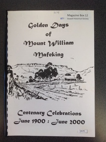
Book, Ida Stanton, Golden Days of Mount William Mafeking - Centenary Celebrations June 1900 : June 2000, 2000
... The history of gold mining at Mount William and Mafeking...The history of gold mining at Mount William and Mafeking ...The history of gold mining at Mount William and MafekingWhite light card/ Thick Paper. with black line drawing of a home in the foreground and a mountain range in the background, print above and below the drawing. With Black plastic combe bindingTitle: Golden Days of Mount William Mafeking Centenary Celebrations June 1900 : June 2000stawell mining -
 Stawell Historical Society Inc
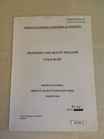
Book, Ararat & District Historical Society, Mafeking and Mount William Gold Rush, 1964
... Gold mining in the Mafeking and Mount Willaim Areas...Gold mining in the Mafeking and Mount Willaim Areas stawell ...Gold mining in the Mafeking and Mount Willaim AreasWhite Paper cover with Printed title and other information. Staple in top left cornerArarat & District Historical Society Mafeking And Mount William Gold Rush Produced During Shire of Ararat Centenary Week March 1964 Price $1.50 Langi Morgala Museum Araratstawell mining -
 Bendigo Historical Society Inc.
Document - MCCOLL, RANKIN AND STANISTREET COLLECTION:CENTRAL DEBORAH GOLD MINE, 1949-51
... 'Bank Account Book for Central Deborah Gold Mining Co. from... Account Book for Central Deborah Gold Mining Co. from McColl ...'Bank Account Book for Central Deborah Gold Mining Co. from McColl,Rankin & Stanistreet-Legal Managers & Accountants Bendigo '. Printed on label 'IN ACCOUNT CURRENT WITH THE UNION BANK OF AUSTRALIA LIMITED'. Hand writing 'Central Deborah Gold Mining Co. No. Liability Supreme Account Bendigo'.The Union Bank Of Australiadocument, gold, central deborah gold mine, central deborah gold mine, gold, mine, mccoll rankin & stanistreet, the union bank of australia, bendigo, business records -
Clunes Museum
document
... AND EXTRACTION, PLAN OF GOLD MINING COMPANIES... Charing Cross London 1882) .5 PLAN OF GOLD MINING CO'S. CLUNES... OF GOLD MINING COMPANIES local history mining company exploration ...INFORMATION ABOUT A STAMP SHOE FROM A CORNISH STYLE SQUARE-HEAD STAMP BATTERY POSSIBLY USED BY PORT PHILLIP MINE, CLUNES, FROM MATTHEW CHURCHWARD, SENIOR CURATOR, ENGINEERING & TRANSPORT, MUSEUM OF VICTORIA LETTER DATED 15 OCTOBER, 1997. THE GOLDFIELDS AND MINERAL DISTRICTS OF VICTORIA. GOLD ITS OCCURRENCE AND EXTRACTION, PLAN OF GOLD MINING COMPANIESINFORMATION RECEIVED REGARDING THE PORT PHILLIP MINE; Including .1 COPY OF ARTICLE 12TH MAY, 1858 FROM "THE ARGUS." MELBOURNE. .2 LETTER FROM "SCIENCEWORKS" TO MR. ALAN KEEBLE DATED 15/10/1997 (3 Pages) .3 SECTION OF MERCURY, TROUGHS, STAKES & STAMPS (Extract taken from publication, The Gold Fields, Mineral Districts of Victoria, by R. Brough Smyth F.G.S, published by Queensberry Hill Press 1979) .4 GOLD. ITS OCCURRENCE AND EXTRACTION (Extract taken from publication, Gold: Its Occurrence and Extraction by Alfred G. Lock F.R.G.S published by E. & F. N. Spon 16 Charing Cross London 1882) .5 PLAN OF GOLD MINING CO'S. CLUNES (Extract taken from Dicker's Mining Record 26/3/1867, page 173. https://trove.nla.gov.au/work/32734386?q&versionId=39944948) local history, mining, company exploration -
 Bendigo Historical Society Inc.
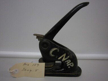
Tool - MCCOLL,RANKIN,STANISTREET COLLECTION: COMPANY SEAL
... company seal for the Central Napoleon Gold Mining Company, used... Napoleon Gold Mining Company, used to seal all official documents ...Collection McColl,Rankin,Stanistreet. Cast iron hand press company seal for the Central Napoleon Gold Mining Company, used to seal all official documents pertaining to the Central Napoleon Gold Mining Company. Black enamelled body and handle with brass seal, written in white paint C.Nap.commerce, office equipment, company seal -
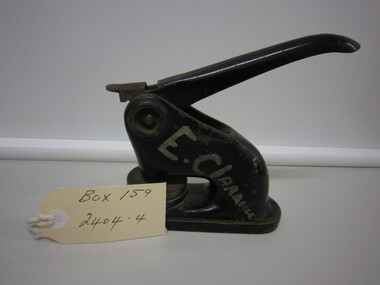 Bendigo Historical Society Inc.
Tool - MCCOLL,RANKIN,STANISTREET COLLECTION: COMPANY SEAL
... company seal for the East Clarence Gold Mining Company, used... Gold Mining Company, used to seal all official documents ...Collection McColl,Rankin,Stanistreet. Cast iron hand press company seal for the East Clarence Gold Mining Company, used to seal all official documents pertaining to the East Clarence Gold Mining Company. Black enamelled body and handle with brass seal, written in white paint E.Clarance.commerce, office equipment, company seal -
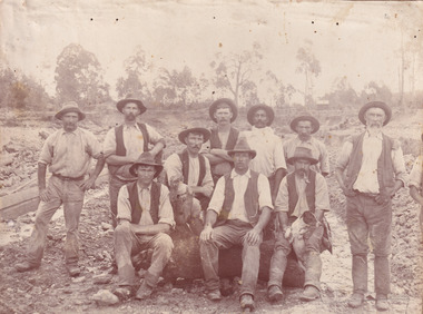 The Beechworth Burke Museum
Photograph, c. 1870
... gold mining... in this period and the impact of mining for gold on both society ...This photograph was captured at an undisclosed location and at an unidentified time but likely dates to approximately 1870. The photographer's details are not recorded and the identities of the men in the image are also not known. This image depicts a group of 10 men in typical miners fashion. Four of them are sat on a large log with one holding a small dog. Six miners stand behind those sitting. All these men are wearing a white button-up shirt and tan coloured work trousers. They wear heavy boots and seven have included a dark vest over their shirt. The man holding the dog has a pipe in his mouth. Two of these men are clean shaven with the remainder sporting a moustache and two with a beard. The ages of these men vary from late 20s to middle age. This group of men are located in a mining location with what appears to be an open cut mine in the background of the image. The ground is muddy and has elements which can help identify it as a mining location based on the condition of the landscape. The bottom of the men's trousers are muddy which provides the assurance that these men were working in this location when their photograph was captured. In the background there is one structure, possibly a dwelling, and bush which identifies the location as Australia. Open cut sluicing is a method used to extract gold and other precious metals from beneath the surface of the earth. This technique involved the use of high-powered hoses which broke down the soil enabling miners to come along and search this soil for gold. After the gold rush of the early 1850s, diggers had to enlist the assistance of heavy machinery and techniques like hydraulic sluicing in order to reach gold because the surface alluvial gold had already been discovered and removed. This heavy machinery was not used until after 1853. The search for gold is ingrained into the history of Victoria and therefore, images like this one which portray an open cut sluicing site can reveal important information for society and technology for the date when the photograph was taken. This image is of important historical significance for its ability to convey information about sluicing and the methods used to find gold in the late 1800s and early 1900s. It also shows a location where sluicing was undertook which provides insight into the impact of sluicing on the environment at a time when it was done. Images, like this one, of Australian gold rush history can reveal important information about the social and environmental impact of this period. This image depicts diggers standing in a mining location and therefore, this image has the capacity to reveal or support significant information for researchers studying the fashion and social status of diggers in Australia in approximately 1870. It can also provide information on the landscape of Australia in this period and the impact of mining for gold on both society and the Australian landscape. The Burke Museum is home to a substantial collection of Australian mining photographs which can be used to gain a deeper understanding into life on the gold fields, technology used in mining, the miners themselves and the impact of the gold digging on the environment.Sepia toned rectangular photograph printed on matte photographic paper mounted on board.Reverse: 1997.2518mining, goldfields, beechworth, 1870, australia, australian goldfields, diggers, victoria, sluicing, gold mining, miners, diggers victoria -
 The Beechworth Burke Museum
Photograph - Photograph - Reproduction, 1890-1900
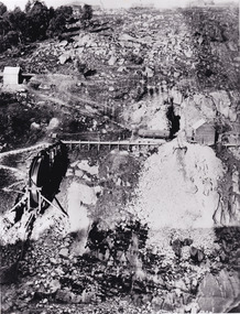
... gold mining... Spring Creek Goldfield to allow for mining access in the area ...The photograph appears to depict the of the entrance to the Rocky Mountain Tunnel. The Rocky Mountain Tunnel runs from opening of the tunnel, underneath the Beechworth town, to the Gorge. This tunnel drained the excess water from the upper Spring Creek Goldfield to allow for mining access in the area. The Rocky Mountain Co. blasted through the granite rock to create the original 400ft-long tunnel in 1859, but between 1867 and 1871, the Rocky Mountain Gold Sluicing Co. widened and extended it. At its completion, it measured 14ft deep, 6ft wide, and almost half a mile long. The mining surveyor at Beechworth called it 'without doubt, the greatest undertaking of the kind in the colony'. When the company became the Rocky Mountain Extended Gold Sluicing Co. in the mid-1870s, they continued the tunnelling work. The work was reportedly vital to mining being able to continue at Beechworth and may have established world records in tunnelling through hard rock. The entrance at the Gorge side of the tunnel can be seen from the Beechworth Gorge Walk. The tunnel continues to be an outfall drain for the lake and the town.The search for gold is ingrained into the history of Victoria and therefore, images like this one which portray an open cut sluicing site can reveal important information for society and technology for the date when the photograph was taken. This image is of important historical significance for its ability to convey information about sluicing and the methods used to find gold in the late 1800s and early 1900s. It also shows a location where sluicing was undertook which provides insight into the impact of sluicing on the environment at a time when it was done. The Burke Museum is home to a substantial collection of Australian mining photographs which can be used to gain a deeper understanding into life on the gold fields, technology used in mining, the miners themselves and the impact of the gold digging on the environment.A black and white rectangular reproduced photograph printed on matte photographic paper.7814beechworth, beechworth museum, burke museum, australian museum, mining, rocky mountain mining co., rocky mountain mining company, mine, mining company, rocky mountain mine, mine entrance, rocky mountain, gold, gold mining -
 The Beechworth Burke Museum
Photograph - Photograph - Reproduction
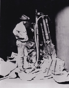
... gold mining... sluicing gold and tin mine mining gold mining beechworth burke ...This photo depicts a man standing next to a large piece of mining equipment identified as a hydraulic chisel (alternative name: drifter dill or power rock drill). This piece of machinery was used in mining to place holes in the walls of a mine which were then filled with dynamite or other explosives for rock blasting or to make holes for plug and feather quarrying. The additional tools to the right of the photograph and in front of the machinery can be identified as either picks or as feather and wedges, the latter of which were used to split stone drilled by the hydraulic or power chisel. Depending on the date of the photograph, which is not provided, this chisel was either powered by electricity or by hydraulics. The following is written on the drill "R.C. FORD'S PATENT No91 / MELBOURNE VICTORIA 1879". The man depicted in this photograph wears a wide brim hat, a loose fitting white shirt and loose pants. He wears boots and has a medium sized dark beard. This attire, along with his locality in the mine and proficiency with the mining equipment, identifies this man as a miner working in this particular, but unidentified, mine. It depicts an instance of hydraulic chiseling which makes this photograph valuable for the study of mining techniques from a date c1880.The search for gold is ingrained into the history of Victoria and therefore, images like this one which portray the types of machinery used in mining can reveal important information for technology and highlight the methods used to break apart the earth in order to obtain access to gold and other precious materials during the period this photograph was captured. Further research into RC Ford can potentially reveal even further information pertaining to this photograph. This image is of important historical significance for its ability to convey information about the methods and machinery used to access gold or mine more in general. It also highlights the size of machinery at the time and allows us to compare this to the size of the person standing besides the machinery to better understand the manpower which would have been required to use and set-up this macinery.A black and white rectangular reproduced photograph printed on matte photographic paper.Reverse: 7816/ copy 1/3gold, sluicing, gold sluicing, hydraulic sluicing, gold and tin mine, mining, gold mining, beechworth, burke museum, melbourne, victoria, hat, mining machinery, machinery, r. c. ford