Showing 2733 items
matching 1890
-
 Orbost & District Historical Society
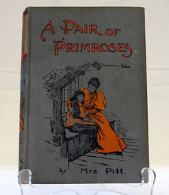
book, Cassell and Company Limited, A Pair of Primroses by Mrs Pitt, 1900
This book was won by Daisy Close, born in 1899, of Murrangowar. She was Ethel Pike's mother. Daisy Close married Ed Jensen. The Jensen family lived at Murrangowar in the 1890's. they were farmers and relatives still live in Orbost.This book, together with a writing box form part of the history of the Close family who were early settlers at Murrangowar in the late 19th century.A grey- covered hard back book with black and orange illustration. The title is in orange print.Prize awarded to Daisy Close 1st class For most popular child in the school SS 3693 Murrangowar Dec 12th-1911book close murrangowar -
 Glen Eira Historical Society
Document - St Giles Presbyterian Church, Murrumbeena
One item about the history of this Church for later period: Two copies of the booklet ST GILES 1890 TO 1990, ONE HUNDRED YEARS IN MURRUMBEENA, dated 15/07/1990 by St Giles Publicity Committee, includes photographs.st giles presbyterian church, murrumbeena presbyterian church, murrumbeena methodist church, ministers, sunday schools, uniting church, armstrong w. j., armstrong w. j. mrs., secomb w. e. rev., andrews mr., crabtree mr., hocking mr., hocking mrs., dandenong road, belgrave road, murrumbeena, harwood c., oakleigh carnegie circuit, sunday schools, murrumbeena methodist men’s movement, hartley f. rev., orton j. russell rev., manzoney w. s. rev., shotton h. t. rev., eldridge l. b. rev., wilcock s. c. rev., bye r. rev., slattery k. rev., archbold b. rev., sunderland h. rev., blanksby a., mcdonald n., porritt d., lukies j., reid g., orton a., reid g., orton a., reid pris, reid will, pollock lex rev., pollock mabel, evans derek rev., mclean colin rev., denholm robin rev., mcrae dick, elmore frank rev., tara grove, brown robert rev., murrumbeena, murrumbeena road, church groups -
 Stawell Historical Society Inc
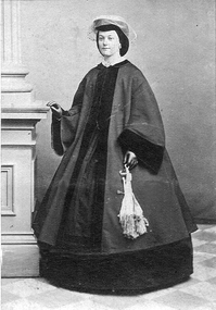
Photograph, Mrs Elizabeth Ann Grant nee Parkinson
Elizabeth Ann Grant nee Parkinson died 1921 aged 77 years in Melbourne. Buried Stawell Cemetery with her husband Edmond Craigie Grant. Photo taken c 1885 - 1890. see more information 119.4.Photograph of Elizabeth Ann Grant nee Parkinson in a long outfit holding a decorative purse in her left hand.stawell portrait -
 Glen Eira City Council History and Heritage Collection
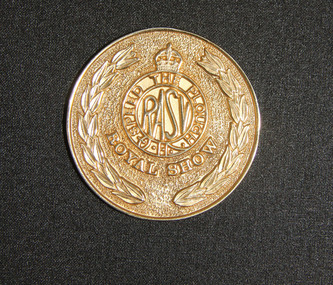
Medal, 1981
Established in 1870, the National (renamed the Royal in 1890) Agricultural Society of Victoria, uses 'Speed the Plough' as its motto which is embossed on the medal. The engraved part of this medal reads “City of Caulfield Horticultural Display 1981, 1st Prize".Round, gold plated medal measuring 50mm in diameter with "The Royal Agricultural Society of Victoria" embossed around edge, an engraved central plate with an embossed representation of a sheep above and cattle below. The engraved side of the medal has "The Royal Agricultural Society of Victoria" around the edge, and the engraved part in the middle reads "CITY of CAULFIELD / HORTICULTURAL DISPLAY / 1981 / 1st Prize". Observe side reads "SPEED THE PLOUGH / RASV / ROYAL SHOW". -
 Eltham District Historical Society Inc
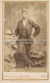
Photograph, Stevenson & McNicoll, Unidentified Shillinglaw Family Male, c.1882
Photographers Stevenson & McNicoll operated from 108 Elizabeth St., Melbourne from 1880-1885. By 1890 they were at 150 Elizabeth Street. CARTE-DE-VISITE (cdv) 1857-1890 Cartes-de-visite (cdv's) are the most common form of photograph from the nineteenth century, generally measuring two and a half inches by four and an eighth inches (6.3 x 10.5 cm) when mounted, sepia toned, mounted on a card which was generally printed with the photographer's name and address on the back or beneath the portrait. - Frost, Lenore; Dating Family Photos 1850-1920; Valiant Press Pty. Ltd., Berwick, Victoria 1991marg ball collection, shillinglaw family photo album 1, 1880-1885, 1882, male shillinglaw 4, stevenson & mcnicoll photographers108 elizabeth st melbourne, unknown -
 Orbost & District Historical Society
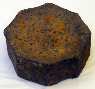
iron weight
This is possibly part of an old gold stamping machine from the Club Terrace/Combienbar/Bendoc area. It could have been used in the gold mining industry between 1890-1920. (Information from Lachlan Macalister - 11/11/2013.)A heavy solid iron octagonal shaped weight. One side is concave.iron-weight gold-mining-processing -
 Warrnambool and District Historical Society Inc.
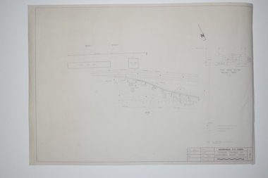
Documents, WCC Proposed turntable site railway station, 1968; 1989
These two plans are copies and show drawings for a proposed turntable at the Warrnambool Railway Station and railway crossings at Gilles Street in the Liebig Street precinct. The Warrnambool Railway was opened in 1890 and the Warrnambool Railway Station building was erected a few years later. These plans, being copies, are of minor interest as they show plans of some projects in the Warrnambool Railway Station precinct in the latter half of the 20th century.These are two sheets of cream-coloured paper with plans (copies of original) drawn up in black ink. The drawings are fading somewhat and are faint in places. One sheet (.2) has a piece missing from the top left hand corner. .1 ‘Locality Plan of Rail Crossings Liebig St. & Gillies (sic) St.’ .2 ‘Proposed Turntable Site Warrnambool Railway Station’ plans, warrnambool railway, warrnambool rail turntable -
 Eltham District Historical Society Inc
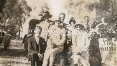
Photograph, At Margies wedding, 1927
Margery Pitt Withers was born 13 January 1890 at Handsworth, Warwickshire, England. Her mother Fanny had travelled back to England at the time to visit her ailing father. She married Richard Matthew McCann in Victoria in 1927Many items in this collection have suffered from significant water damage and black mouldjohn withers collection, eltham, 1927, margery pitt withers, richard matthew mccann, wedding -
 Warrnambool and District Historical Society Inc.
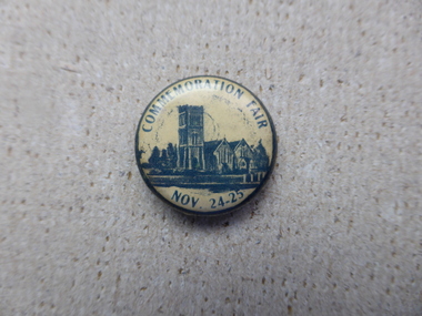
Badge - Commemoration Fair Nov 24-25, Circa early –mid 20th century
The Christ Church fetes and flower shows have been a part of Christ Church social and fundraising agenda since the 1890’s, with the ladies’ guild playing a large part in their organization and operation. This badge is a memento from one of those fairs.A small item which relates to a local social event.Small circular cream badge with dark blue text and illustration of Christ Church Warrnambool.Commemoration Fair Nov 24-25 christ church fete, warrnambool -
 Bendigo Historical Society Inc.
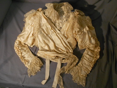
Clothing - BODICE (WEDDING DRESS), 1896
Probably 1890's to early 1900's. The Dress and Mantle Makers departments was part of F. Davey and Co. and the department was run by Miss Middleton, formerly of the Beehive. F Davey and Co. sold their View Point premises in Oct 1904.Bodice (Wedding dress), hand and machine stitched. Silk lined with polished cotton. Slim ruched sleeves - ruched at inner and elbow side of sleeve (hand sewn). Elbow edge of ruching forms two ''frilled pleats'' down the sleeve to the wrist. Wrist edge lily pointed and finished with a 9 cm underfill of cotton lace. Top of sleeves have a leg-o-mutton balloon effect panel sewn at the shoulder and the upper arm. This balloon effect hangs down over the sleeves almost to the elbow. Top of sleeve has an embroidered lace frill hanging over armhole. Two silk bows are placed at the shoulders. Stand-up collar,5 cm deep is finished on each side with a pearl and glass beaded bow motif- 6cm in diameter. Hook and eye fasteners down front-metal loops covered with button hole stitch. Bodice boned with thirteen (13) ''bones''. Each pocket finished with a fan pattern stitching. Linen panel, with a diamond shaped weave stitched at each underarm. Front bodice is pleated from shoulders to centre front. Right front laps across left to fasten with a hook on the left shoulder. This panel is heavily beaded with glass beads and sequins. Over panel from right shoulder fastens with hook and eye at left hip line,with the pleated panel circling the waist.Matching skirt 11400.315.F.Davey & Co, Dress & Mantle Makers, View point, Sandhurst Label stitched at inside waistline of bodice.costume, female, wedding dress bodice -
 Bendigo Historical Society Inc.
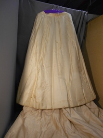
Clothing - SKIRT (WEDDING DRESS), 1896
Probably 1890's to early 1900's. The Dress and Mantle Makers departments was part of F. Davey and Co. and the department was run by Miss Middleton, formerly of the Beehive. F Davey and Co. sold their View Point premises in Oct 1904.Cream coloured silk wedding dress with train. Three flat panels at front and side, lined with polished cotton. Centre tightly gathered panel at centre back lined with stiffened cotton.Other panels lined with stiffened cotton above hemline of skirt. Double layer lace insert inside lower edge to hemline. Back opening with four hook and eye fasteners. Deep pocket on side seam at hip on RHS. Three back panels extended below hemline of skirt to form squared edge train. Two hanging tapes inside waist band. Skirt hand and machine stitched. Matching bodice 11400.314.Label stitched inside skirt waistband - ''F.Davey & Co Dress & Mantle makers, View Point, Sandhurst.costume, female, wedding dress skirt -
 Bendigo Historical Society Inc.
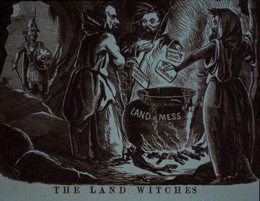
Slide - DIGGERS & MINING. LIFE OF THE SELECTORS, c1860
Diggers & Mining. Life Of The Selectors. Diggers & Mining. A soldier looks on as three male witches stand around a cauldron placing cards in the pot with OCCUPATION LICENSES, LEASE HOLDS and AGRICULTURAL AREAS written on them, the cauldron is labelled LAND MESS. The title of the picture is 'The Land Witches'. Markings; Life Of The Selectors 1860-1890 Set 432 No. 16. The Land Witches ''Melbourne Punch,'' Feb 25, 1864. Used as a teaching aid.Visual Eduation Centreeducation, tertiary, goldfields -
 Bendigo Historical Society Inc.
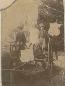
Photograph - EASTER FAIR, JUVENILE FIRE BRIGADE, c1890's
Sepia photograph of group of children. Two girls, two boys on hand card. Four shields and banner decoration. Lion statue on right front. One boy in Scottish dress. One with top hat with feather. Girls with coronets. On back - 'Easter Procession Exhibit, 1890's +, probably Juvenile Fire Brigade' . On back - 3cls, p8, A feast', 'Royal Historical Society of Victoria, Bendigo Branch' circular stamp.person, group, easter procession -
 Bendigo Historical Society Inc.
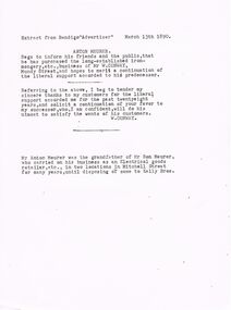
Document - ANTON MEURER
Typed extract from The Bendigo Advertiser dated March 13th 1890. Article mentions Anton Meurer has purchased the ironmongery business of Mr W Conway. Also a short note from W. Conway thanking his customers for their support and his confidence in the new owner satisfying the wants of his customers. Mr Anton Meurer was the grandfather of Mr Ron Meurer who had an electrical goods store.document, names of bendigo pioneers, bendigo advertiser, anton meurer, bendigo advertiser 13/3/1890, mr w conway, mr ron meurer, kelly bros. -
 Whitehorse Historical Society Inc.
Document, Nunawading, ?1995
Photocopy of search notes summarising memorials relating to part Crown Portions 80,81,82,89,90 and 91 originally granted to John Woods, 31 March 1855 and transferred to Frederick Walter Purches, Edwin James Purches, George Seth Coppin, Freehold Investment and Banking Co of Australia and Australian Deposit and Mortgage Bank; with page listing titles derived from Freehold Investment and Banking Co of Australia Limited 1889 - 1890.non-fictionmorton thomas richards burrowes -
 Bendigo Historical Society Inc.
Administrative record - Land Leases 1886 - 1899
Dr Ralph Birrell (20/3/1927 - 7/6/2014) was a lecturer at the Bendigo School of mines and the author of numerous books about mining in Victoria, particularly Bendigo, and books on various elements of Bendigo history.Set of handwritten land leases books compiled by Ralph Birrell. Book 17: 5156/5573, year 1886. Book 18: 5574/5891. year 1887. Book 19: 5892/6211, year 1890. Book 20: 6212/6531, year 1893. Book 21: 6532/6849, year 1896. Book 22: 6849/71765, year 1897. Book 23: 7166/7390, year 1899.land leases, 1886-1899 -
 Mont De Lancey
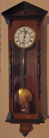
Functional object - Wall Clock, late 1800's
History of Clock Wandin North 8th Jan'y 1952. This clock was bought by the late Henry Sebire of 'Mont de Lancey' Wandin Yallock, at a clearing sale of Mrs Newey's at Seville about the year 1890; After his death in July 1902 the clock was given to his eldest son, one of his Executors, (Henry T. Sebire) of Ivanhoe, who died on 29th November 1935. On 6th February 1945 nearly 10 years later Mrs H. T. Sebire gave the clock to Wandin T. Sebire of Wandin North, who very much appreciated the gift. The clock was called for at Ivanhoe by Len Sebire, on 21st March 1945. Wandin T. Sebire. The clock was oiled and repaired by Mr Upton Watchmaker of Wandin North returned by him on 4th Dec 1951. Oiled again and returned 7th Feb. 1953.A tall narrow pendulum wooden wall clock with a white round clock face, with Roman numerals, elaborate fine hands and a brass pendulum enclosed in a glass faced compartment which has a decorative dark wood at the top. There are small clips at the top and bottom to open the case door. A brass key is stored inside the cabinet.This note was attached to the donation sheet. 'History of Clock Wandin North 8th Jan'y 1952. This clock was bought by the late Henry Sebire of 'Mont de Lancey' Wandin Yallock, at a clearing sale of Mrs Newey's at Seville about the year 1890; After his death in July 1902 the clock was given to his eldest son, one of his Executors, (Henry T. Sebire) of Ivanhoe, who died on 29th November 1935. On 6th February 1945 nearly 10 years later Mrs H. T. This note was attached to the donation sheet. Sebire gave the clock to Wandin T. Sebire of Wandin North, who very much appreciated the gift. The clock was called for at Ivanhoe by Len Sebire, on 21st March 1945. Wandin T. Sebire. The clock was oiled and repaired by Mr Upton Watchmaker of Wandin North returned by him on 4th Dec 1951. Oiled again and returned 7th Feb. 1953.'wall clocks, plaques -
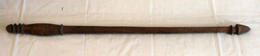 Orbost & District Historical Society
hunting stick
Inspected by Joanna Freslov, archaeologist 2.6.2008. This club was brought from New Hebrides to Orbost by Reverend Alex Morton in 1894. Morton was the minister at the Presbyterian church about 1890. He had spent time in new Hebrides and went on to New Zealand.A handmade carved wooden club with carved rings at top and bottom.weapon new-hebrides hunting-club morton -
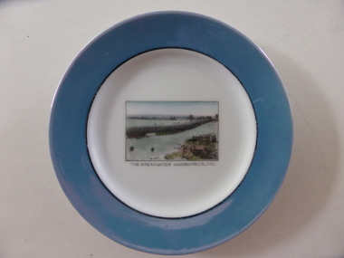 Warrnambool and District Historical Society Inc.
Souvenir plate, The breakwater, Mid 20th century
This item has been bought as a souvenir of Warrnambool probably by a tourist. It features the breakwater built in 1890 to assist shipping in the port of Warrnambool . Tourism is important in Warrnambool today - in Summer the coastal scenery and the beaches and in Winter the with the whale season and the May Racing Carnival This item is of minor interest as an example of a tourist souvenir of Warrnambool.Small circular plate with pale blue border with interior black ring. The centre of the plate is white and has a rectangular image of the breakwater.The breakwater Warrnambool Vic is in black text underneath the image. Noritake made in Japan in green on back of the platewarrnamool breakwater -
Glenelg Shire Council Cultural Collection
Photograph - Photograph - Portland Gaol, n.d
The Gaol at Portland was in operation as early as 1852. It was reproclaimed in the Government Gazette, along with several other prisons in the colony, in October 1877. In 1892, it was proclaimed a Police Gaol, under the provisions of the Gaols Act 1890. The Police Gaol was closed by proclamation in March 1893.Black and white photo of gaol at Portland, two sides visible. High stone walls, roof of building visible behind walls. Large stone pillars either side of wooden entrance. Dilapidated wooden fence, cow grazing in foreground.Front: 'THE FIRST JAIL IN VICTORIA, PORTLAND' - white print on bottom edge of photoportland gaol, jail, incarceration, prison -
 Kew Historical Society Inc
Map, MMBW, MMBW Town of Kew, 1910-21
The Melbourne and Metropolitan Board of Works (MMBW) was established by an act of the Victorian Parliament in 1890 to prepare for and to implement a sewerage and water reticulation system across what was then inner Melbourne, its surrounding and middle distance suburbs, including Kew. The MMBW was disbanded in 1991.The map collection of the Kew Historical Society has at its core the historic maps assembled and originally stored in the City Engineer's Department of the City of Kew. These include maps in a number of scales. The vast majority of maps were produced by the MMBW in the first two decades of the twentieth century, and are solid working maps, backed by linen for durability. These maps are historically significant to Kew, the City of Boroondara and to the history of the development of state utilities in Victoria. A number of the Kew maps have additional details added by former municipal officers, including the levels reached by various floods. As these were working documents, information was added to them long after the period of their initial production and distribution.Early map of the Town of Kew, created after 1910, at a scale 440 ft to 1 inch. The 'assembled' map by the City of Kew Engineer's Department includes scaled down copies of The Melbourne and Metropolitan Board of Works maps, Nos. 39, 40, 64, 65, 66, 67, 68, and 117. The map covers the entirety of the Town of Kew, bordered on its north and west by the River Yarra, by Burke Road in the East and Barkers Road in the south. The map shows the extent of urban development by that time, prominent institutions and the outlines of built structures in the municipality. TOWN OF KEW / SCALE 400 FEET TO 1 INCHmelbourne & metropolitan board of works, mmbw maps, mmbw plans, town of kew, cartography -
 Kew Historical Society Inc
Map, MMBW, MMBW Plan No.39 Kew & Heidelberg, 1900-1910
The Melbourne and Metropolitan Board of Works (MMBW) was established by an act of the Victorian Parliament in 1890 to prepare for and to implement a sewerage and water reticulation system across what was then inner Melbourne, its surrounding and middle distance suburbs, including Kew. The MMBW was disbanded in 1991.The map collection of the Kew Historical Society has at its core the historic maps assembled and originally stored in the City Engineer's Department of the City of Kew. These include maps in a number of scales. The vast majority of maps were produced by the MMBW in the first two decades of the twentieth century, and are solid working maps, backed by linen for durability. These maps are historically significant to Kew, the City of Boroondara and to the history of the development of state utilities in Victoria. A number of the Kew maps have additional details added by former municipal officers, including the levels reached by various floods. As these were working documents, information was added to them long after the period of their initial production and distribution.Early map of part of the Borough of Kew, created in the first decade of the twentieth century, at a scale 160 ft to 1 inch. The map covers what was then the north western section of Kew, bordered on its north by Wills Street and the Kew Lunatic Asylum, in the west by the River Yarra [and the later added Yarra Boulevard] , by Princess Street in the East and Holroyd Street in the south. The map shows the extent of urban development by that time, prominent institutions and the outlines of built structures in the municipality. Contour lines were added in ink to the map at a later stage.MELBOURNE AND METROPOLITAN BOARD OF WORKS / PLAN NO. 39 / KEW & HEIDELBERGmelbourne & metropolitan board of works, mmbw maps, mmbw plans, borough of kew, cartography -
 Kew Historical Society Inc
Map, MMBW, MMBW Plan No.40 Collingwood & Kew, 1900-1910
The Melbourne and Metropolitan Board of Works (MMBW) was established by an act of the Victorian Parliament in 1890 to prepare for and to implement a sewerage and water reticulation system across what was then inner Melbourne, its surrounding and middle distance suburbs, including Kew. The MMBW was disbanded in 1991.The map collection of the Kew Historical Society has at its core the historic maps assembled and originally stored in the City Engineer's Department of the City of Kew. These include maps in a number of scales. The vast majority of maps were produced by the MMBW in the first two decades of the twentieth century, and are solid working maps, backed by linen for durability. These maps are historically significant to Kew, the City of Boroondara and to the history of the development of state utilities in Victoria. A number of the Kew maps have additional details added by former municipal officers, including the levels reached by various floods. As these were working documents, information was added to them long after the period of their initial production and distribution.Early map of part of the Borough of Kew, created in the first decade of the twentieth century, at a scale 160 ft to 1 inch. The map covers what was then the south western section of Kew, bordered on its north by Studley Park Road, in the west by Walmer Street and the River Yarra, by High Street South and Princess Street in the East and Barkers Road in the south. The map shows the extent of urban development by that time, prominent institutions and the outlines of built structures in the municipality. Contour lines and historic flood levels were added in ink to the map at a later stage.MELBOURNE AND METROPOLITAN BOARD OF WORKS / PLAN NO. 40 / COLLINGWOOD & KEWmelbourne & metropolitan board of works, mmbw maps, mmbw plans, borough of kew, cartography -
 Kew Historical Society Inc
Map, MMBW, MMBW Plan No.64 Kew & Heidelberg, 1900-1910
The Melbourne and Metropolitan Board of Works (MMBW) was established by an act of the Victorian Parliament in 1890 to prepare for and to implement a sewerage and water reticulation system across what was then inner Melbourne, its surrounding and middle distance suburbs, including Kew. The MMBW was disbanded in 1991.The map collection of the Kew Historical Society has at its core the historic maps assembled and originally stored in the City Engineer's Department of the City of Kew. These include maps in a number of scales. The vast majority of maps were produced by the MMBW in the first two decades of the twentieth century, and are solid working maps, backed by linen for durability. These maps are historically significant to Kew, the City of Boroondara and to the history of the development of state utilities in Victoria. A number of the Kew maps have additional details added by former municipal officers, including the levels reached by various floods. As these were working documents, information was added to them long after the period of their initial production and distribution.Early map of part of the Borough of Kew, created in the first decade of the twentieth century, at a scale 160 ft to 1 inch. The map covers what was then the northern most part of Kew, bordered on its north and west by the Yarra River, in the East by Connor's Creek and by the Asylum in the south. The map shows the extent of urban development by that time, prominent institutions and the outlines of built structures in the municipality. Contour lines and historic flood levels were added in ink to the map at a later stage.MELBOURNE AND METROPOLITAN BOARD OF WORKS / PLAN NO. 64 / KEW & HEIDELBERGmelbourne & metropolitan board of works, mmbw maps, mmbw plans, borough of kew, cartography -
 Kew Historical Society Inc
Map, MMBW, MMBW Plan No.65 Kew & Heidelberg, 1900-1910
The Melbourne and Metropolitan Board of Works (MMBW) was established by an act of the Victorian Parliament in 1890 to prepare for and to implement a sewerage and water reticulation system across what was then inner Melbourne, its surrounding and middle distance suburbs, including Kew. The MMBW was disbanded in 1991.The map collection of the Kew Historical Society has at its core the historic maps assembled and originally stored in the City Engineer's Department of the City of Kew. These include maps in a number of scales. The vast majority of maps were produced by the MMBW in the first two decades of the twentieth century, and are solid working maps, backed by linen for durability. These maps are historically significant to Kew, the City of Boroondara and to the history of the development of state utilities in Victoria. A number of the Kew maps have additional details added by former municipal officers, including the levels reached by various floods. As these were working documents, information was added to them long after the period of their initial production and distribution.Early map of part of the Borough of Kew, created in the first decade of the twentieth century, at a scale 160 ft to 1 inch. The map covers what was then the south central part of Kew, bordered on its north by Malmsbury Street, in the west by Florence Avenue, in the south by Barkers Road, and in the east by Princess Street. The map shows the extent of urban development by that time, prominent institutions and the outlines of built structures in the municipality. Contour lines were added in ink to the map at a later stage.MELBOURNE AND METROPOLITAN BOARD OF WORKS / PLAN NO. 65 / KEW & HEIDELBERGmelbourne & metropolitan board of works, mmbw maps, mmbw plans, borough of kew, cartography -
 Kew Historical Society Inc
Map, MMBW, MMBW Plan No.66 Kew, 1900-1910
The Melbourne and Metropolitan Board of Works (MMBW) was established by an act of the Victorian Parliament in 1890 to prepare for and to implement a sewerage and water reticulation system across what was then inner Melbourne, its surrounding and middle distance suburbs, including Kew. The MMBW was disbanded in 1991.The map collection of the Kew Historical Society has at its core the historic maps assembled and originally stored in the City Engineer's Department of the City of Kew. These include maps in a number of scales. The vast majority of maps were produced by the MMBW in the first two decades of the twentieth century, and are solid working maps, backed by linen for durability. These maps are historically significant to Kew, the City of Boroondara and to the history of the development of state utilities in Victoria. A number of the Kew maps have additional details added by former municipal officers, including the levels reached by various floods. As these were working documents, information was added to them long after the period of their initial production and distribution.Early map of part of the Borough of Kew, created in the first decade of the twentieth century, at a scale 160 ft to 1 inch. The map covers what was then the south eastern part of Kew, bordered on its north by Adeney Avenue, in the west by Sackville Street, in the south by Barkers Road, and in the east by Burke Road. The map shows the extent of urban development by that time, prominent institutions and the outlines of built structures in the municipality. Contour lines were added in ink to the map at a later stage.MELBOURNE AND METROPOLITAN BOARD OF WORKS / PLAN NO. 66 / KEW melbourne & metropolitan board of works, mmbw maps, mmbw plans, borough of kew, cartography -
 Kew Historical Society Inc
Map, MMBW, MMBW Plan No.67 Kew, 1900-1910
The Melbourne and Metropolitan Board of Works (MMBW) was established by an act of the Victorian Parliament in 1890 to prepare for and to implement a sewerage and water reticulation system across what was then inner Melbourne, its surrounding and middle distance suburbs, including Kew. The MMBW was disbanded in 1991.The map collection of the Kew Historical Society has at its core the historic maps assembled and originally stored in the City Engineer's Department of the City of Kew. These include maps in a number of scales. The vast majority of maps were produced by the MMBW in the first two decades of the twentieth century, and are solid working maps, backed by linen for durability. These maps are historically significant to Kew, the City of Boroondara and to the history of the development of state utilities in Victoria. A number of the Kew maps have additional details added by former municipal officers, including the levels reached by various floods. As these were working documents, information was added to them long after the period of their initial production and distribution.Early map of part of the Borough of Kew, created in the first decade of the twentieth century, at a scale 160 ft to 1 inch. The map covers what was then the north central part of Kew, bordered on its north by the Outer Circle Railway Spruzen and Beresford Avenues, in the west by Princess Street, in the south by High Street, and in the east by (about) Belford Road. The map shows the extent of urban development by that time, prominent institutions and the outlines of built structures in the municipality. Contour lines were added in ink to the map at a later stage.MELBOURNE AND METROPOLITAN BOARD OF WORKS / PLAN NO. 67 / KEW melbourne & metropolitan board of works, mmbw maps, mmbw plans, borough of kew, cartography -
 Kew Historical Society Inc
Map, MMBW, MMBW Plan No.68 Kew, 1900-1910
The Melbourne and Metropolitan Board of Works (MMBW) was established by an act of the Victorian Parliament in 1890 to prepare for and to implement a sewerage and water reticulation system across what was then inner Melbourne, its surrounding and middle distance suburbs, including Kew. The MMBW was disbanded in 1991.The map collection of the Kew Historical Society has at its core the historic maps assembled and originally stored in the City Engineer's Department of the City of Kew. These include maps in a number of scales. The vast majority of maps were produced by the MMBW in the first two decades of the twentieth century, and are solid working maps, backed by linen for durability. These maps are historically significant to Kew, the City of Boroondara and to the history of the development of state utilities in Victoria. A number of the Kew maps have additional details added by former municipal officers, including the levels reached by various floods. As these were working documents, information was added to them long after the period of their initial production and distribution.Early map of part of the Borough of Kew, created in the first decade of the twentieth century, at a scale 160 ft to 1 inch. The map covers what was then the north central part of Kew, bordered in the north by Oak Avenue, in the west by the Yarra River and Connor's Creek, in the south by Beresford and Carnegie Avenues, and in the east by Glass's Creek and Burke Road. The map shows the extent of urban development by that time, prominent institutions and the outlines of built structures in the municipality. Contour lines and the levels of historic floods were added in ink to the map at a later stage.MELBOURNE AND METROPOLITAN BOARD OF WORKS / PLAN NO. 68 / KEW melbourne & metropolitan board of works, mmbw maps, mmbw plans, borough of kew, cartography -
 Kew Historical Society Inc
Map, MMBW, MMBW Plan No.117 Heidelberg & Kew, 1900-1910
The Melbourne and Metropolitan Board of Works (MMBW) was established by an act of the Victorian Parliament in 1890 to prepare for and to implement a sewerage and water reticulation system across what was then inner Melbourne, its surrounding and middle distance suburbs, including Kew. The MMBW was disbanded in 1991.The map collection of the Kew Historical Society has at its core the historic maps assembled and originally stored in the City Engineer's Department of the City of Kew. These include maps in a number of scales. The vast majority of maps were produced by the MMBW in the first two decades of the twentieth century, and are solid working maps, backed by linen for durability. These maps are historically significant to Kew, the City of Boroondara and to the history of the development of state utilities in Victoria. A number of the Kew maps have additional details added by former municipal officers, including the levels reached by various floods. As these were working documents, information was added to them long after the period of their initial production and distribution.Early map of part of the Borough of Kew, created in the early twentieth century, at a scale 160 ft to 1 inch. The map covers what was then the north eastern part of Kew showing the natural landscape and limited development on the south side of the Yarra River. In the Kew section, south of the river, the land is occupied currently by the Greenacres and Kew Golf Clubs. The map shows the extent of urban development by that time and the outlines of the few built structures in the municipality. The height above sea level of all parts of the landscape are indicated numerically in feet. Contour lines and the levels of historic floods were added in ink to the map at a later stage. MELBOURNE AND METROPOLITAN BOARD OF WORKS / PLAN NO. 117 / HEIDELBERG & KEW melbourne & metropolitan board of works, mmbw maps, borough of kew, cartography, mmbw plan no. 117, kew (vic.) -- maps, heidelberg (vic.) -- maps -
 Kew Historical Society Inc
Map, MMBW, River Yarra Beautification Schemes, c.1913
The Melbourne and Metropolitan Board of Works (MMBW) was established by an act of the Victorian Parliament in 1890 to prepare for and to implement a sewerage and water reticulation system across what was then inner Melbourne, its surrounding and middle distance suburbs, including Kew. The MMBW was disbanded in 1991.The map collection of the Kew Historical Society has at its core the historic maps assembled and originally stored in the City Engineer's Department of the City of Kew. These include maps in a number of scales. The vast majority of maps were produced by the MMBW in the first two decades of the twentieth century, and are solid working maps, backed by linen for durability. These maps are historically significant to Kew, the City of Boroondara and to the history of the development of state utilities in Victoria. A number of the Kew maps have additional details added by former municipal officers, including the levels reached by various floods. As these were working documents, information was added to them long after the period of their initial production and distribution.Map of the City of Kew showing part of the River Yarra Beautification Schemes. The map shows development to date and the flood levels reached in 1923 and 1924. This map may have been adapted from an earlier map, as most development in central Kew and Studley Park had occurred by this date yet numerous streets are not represented. Public buildings and institutions are clearly represented and named on the map as are significant public transport infrastructure (eg the Outer Circle railway).MELBOURNE AND METROPOLITAN BOARD OF WORKS / RIVER YARRA BEAUTIFICATION SCHEMES / SCHEME / SCALE 10 CHAINS TO AN INCHmelbourne & metropolitan board of works, mmbw maps, mmbw plans, city of kew, flood levels -- kew (vic.), cartography