Showing 2482 items matching "kew houses"
-
 Melbourne Legacy
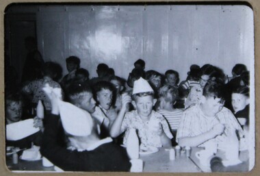
Slide, Legacy Boys Camp 1956-7, 1957
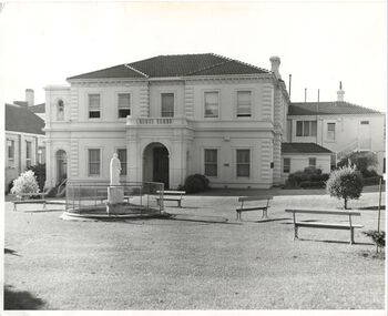
... . It is possibly at Blamey House in Kew, as other slides show camps... at Blamey House in Kew, as other slides show camps at the residence ...Two black and white slides of boys in a dining room at a boys camp in 1956-57. Some are wearing paper hats. It is possibly at Blamey House in Kew, as other slides show camps at the residence during summer holidays. Was with many other slides taken in the 1950s and 1960s. The slides have been photographed to make digital images and moved to archive quality sleeves. In many cases the original images were not well focussed and the digital image the best available.A record of camps being organised for children.Black and white slide photo of boys in a dining room in a cardboard mount.Handwritten on front 'Legacy boys camp 1956-57' in blue pen. Handwritten on one 'SET-2' in blue pen and '12' in black pen. Printed on front 'Made in Australia' on the reverse a navy blue outline on edge of slide.camps, blamey house -
 Melbourne Legacy
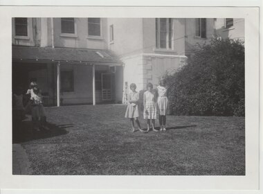
Photograph, Holiday camp at Blamey House 1961, 1961
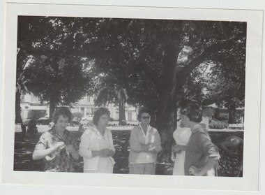
... at Blamey House in Kew. Names provided with the photo: L-R Carol... for a camp in January 1961 on an outing at Como House. The girls came ...A photo of country Junior Legatees that had come to Melbourne for a camp in January 1961 on an outing at Como House. The girls came from all over Victoria and stayed for two weeks at Blamey House in Kew. Names provided with the photo: L-R Carol Farnham, Helen Rogers and Caroline Blackwell. At the time Legatee Bert Davis was CFO and his daughter Louise was asked to help with the running of the camp. Photos donated by Legatee Bert Davis' daughters.A record of outings and camps provided for Junior Legatees in the 1960s.Black and white photo of girls in the courtyard at Como House.camps, blamey house, junior legatee outings -
 Melbourne Legacy
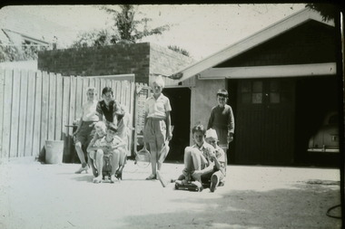
Slide, Legacy Boys Camp 1956-7, 1957
... has two tennis racquets. It is possibly at Blamey House in Kew... racquets. It is possibly at Blamey House in Kew, as other slides ...A black and white slide of eight boys at a boys camp in 1956-57. They could be on billy carts or skateboards. One boy has two tennis racquets. It is possibly at Blamey House in Kew, as other slides show camps at the residence during summer holidays. Was with many other slides taken in the 1950s and 1960s. The slides have been photographed to make digital images and moved to archive quality sleeves. In many cases the original images were not well focussed and the digital image the best available.A record of camps being organised for children.Black and white slide photo of boys in a driveway in a cardboard mount.Handwritten on front 'Legacy boys camp 1956-57' in blue pen. Printed on front 'Made in Australia' on the reverse a navy blue outline on edge of slide.camps, blamey house -
 Kew Historical Society Inc
Archive (Sub-series) - Subject File, Development (Kew), 1958
... /articles relating to houses in Kew. The earliest original newspaper... relating to houses in Kew. The earliest original newspaper article ...Various partiesReference, Research, InformationSecondary Values (KHS Imposed Order)Subject file consisting largely of newspaper clippings/articles relating to houses in Kew. The earliest original newspaper article dates from 1923 and relates to housing shortages. The file contains some interesting Council records and correspondence relating to community action in response to development. These include the proposed lease of the Ground Floor of the Kew Civic Buildings as a postal delivery centre (1992), the development of flats in Studley Ward (1977), a proposed motel in Studley Park Road (1983)kew post office, heritage, planning and developmentkew post office, heritage, planning and development -
 Kew Historical Society Inc
Plan - Subdivision Plan, Jas R Mathers Son & McMillan, Macartney Estate, East Kew, c. 1925
... ) and Evans Road in what was then designated as East Kew. Most... Kew. Most of the houses shown on the south side of Macartney ...Pru Sanderson, in her groundbreaking ‘City of Kew Urban Conservation Study : Volume 2 - Development History’ (1988), summarised the periods of urban development and subdivisions of land in Kew. The periods that she identified included 1845-1880, 1880-1893, 1893-1921, 1921-1933, 1933-1943, and Post-War Development. These periods were selected as they represented periods of rapid growth or decline in urban development. An obvious starting point for Sanderson’s groupings involved population growth and the associated economic cycles. These cycles also highlighted urban expansion onto land that was predominantly rural, although in other cases it represented the decline and breakup of large estates. A number of the plans in the Kew Historical Society’s collection can also be found in other collections, such as those of the State Library of Victoria and the Boroondara Library Service. A number are however unique to the collection.Subdivision plans are historically important documents used as evidence of the growth of suburbs in Australia. They frequently provide information about when the land was sold on which a built structure was subsequently constructed as well as evidence relating to surveyors and real estate and financial agents. The numerous subdivision plans in the Kew Historical Society's collection represent working documents, ranging from the initial sketches made in planning a subdivision to printed plans on which auctioneers or agents listed the prices for which individual lots were sold. In a number of cases, the reverse of a subdivision plan in the collection includes a photograph of a house that was also for sale by the agent. These photographs provide significant heritage information relating house design and decoration, fencing and household gardens.The Macartney Estate subdivision advertised 21 lots for sale on either side of Macartney Street (now Macartney Avenue) and Evans Road in what was then designated as East Kew. Most of the houses shown on the south side of Macartney Street then, as now, have rear entrances on Mount Street, however a number of these blocks have since been further subdivided to allow for the building of new houses on the rear of a block. Brougham Place is marked on the plan but is now called Daniell Place."C"subdivision plans - east kew, macartney estate, macartney street, mount street, evans road, brougham place -
 Melbourne Legacy
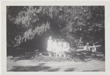
Photograph, Holiday camp at Blamey House 1961, 1961
... at Blamey House in Kew. Names provided with the photo: L-R Caroline... for a camp in January 1961 on an outing at Como House. The girls came ...A photo of country Junior Legatees that had come to Melbourne for a camp in January 1961 on an outing at Como House. The girls came from all over Victoria and stayed for two weeks at Blamey House in Kew. Names provided with the photo: L-R Caroline Blackwell, Helen Rogers, Carol Farnham, Judy Farnham, Barbara Stares, Jill Brinkley. At the time Legatee Bert Davis was CFO and his daughter Louise was asked to help with the running of the camp. Photos donated by Legatee Bert Davis' daughters.A record of outings and camps provided for Junior Legatees in the 1960s.Black and white photo of girls at the fountain at Como House.camps, blamey house, junior legatee outings -
 Kew Historical Society Inc
Photograph, Madford, Wellington Street, circa 1965, c. 1965
... after the sale of the land to the Borough of Kew in 1905. King’s... to the Borough of Kew in 1905. King’s house, and the remaining garden ...This work forms part of the collection assembled by the historian Dorothy Rogers, that was donated to the Kew Historical Society by her son John Rogers in 2015. The manuscripts, photographs, maps, and documents were sourced by her from both family and local collections or produced as references for her print publications. Many were directly used by Rogers in writing ‘Lovely Old Homes of Kew’ (1961) and 'A History of Kew' (1973), or the numerous articles on local history that she produced for suburban newspapers. Most of the photographs in the collection include detailed annotations in her hand. The Rogers Collection provides a comprehensive insight into the working habits of a historian in the 1960s and 1970s. Together it forms the largest privately-donated collection within the archives of the Kew Historical Society.‘Elm Lodge’ had a frontage to Wellington Street and extended to Cotham Road. It was renamed ‘Madford’ in 1874, after its purchase by the pastoralist Arthur Septimus King, the grandson of Philip Gidley King, third Governor of New South Wales. The Alexandra Gardens were developed on the northern section of Madford after the sale of the land to the Borough of Kew in 1905. King’s house, and the remaining garden, was sold to the Catholic Church in 1920, and subsequently developed into ‘St Anthony’s Home for Babies’ in 1922. The organisation relocated to Footscray in 1975, and the building demolished."Madford (formerly Elm Lodge) in Wellington Street Kew during the period when it was St. Anthony's Home for babies (now demolished). From the 1860s it had been the home of the King family. Harold Septimus King was one of the notable residents of Kew."madford, elm lodge, wellington street (kew), dorothy rogers -
 Kew Historical Society Inc
Plan - Subdivision Plan, Violet Farm Estate, 1927
... subdivisions in Kew and East Kew, older houses (Lots 1 and 13) were... subdivisions in Kew and East Kew, older houses (Lots 1 and 13) were ...Pru Sanderson, in her groundbreaking ‘City of Kew Urban Conservation Study : Volume 2 - Development History’ (1988), summarised the periods of urban development and subdivisions of land in Kew. The periods that she identified included 1845-1880, 1880-1893, 1893-1921, 1921-1933, 1933-1943, and Post-War Development. These periods were selected as they represented periods of rapid growth or decline in urban development. An obvious starting point for Sanderson’s groupings involved population growth and the associated economic cycles. These cycles also highlighted urban expansion onto land that was predominantly rural, although in other cases it represented the decline and breakup of large estates. A number of the plans in the Kew Historical Society’s collection can also be found in other collections, such as those of the State Library of Victoria and the Boroondara Library Service. A number are however unique to the collection.The Kew Historical Society collection includes almost 100 subdivision plans pertaining to suburbs of the City of Melbourne. Most of these are of Kew, Kew East or Studley Park, although a smaller number are plans of Camberwell, Deepdene, Balwyn and Hawthorn. It is believed that the majority of the plans were gifted to the Society by persons connected with the real estate firm - J. R. Mathers and McMillan, 136 Cotham Road, Kew. The Plans in the collection are rarely in pristine form, being working plans on which the agent would write notes and record lots sold and the prices of these.The subdivision plans are historically significant examples of the growth of urban Melbourne from the beginning of the 20th Century up until the 1980s. A number of the plans are double-sided and often include a photograph on the reverse. A subdivision plan for nineteen ‘bonny, airy building blocks’ on either side of Violet Grove, Kew East. Violet Grove runs between High Street and Harp Road. Like many other subdivisions in Kew and East Kew, older houses (Lots 1 and 13) were often included in the subdivision. Such houses were in some instances the original properties that were subdivided, or in the case of the Violet Grove subdivision, new houses such as the weatherboard villa on lot 13. This villa is advertised as having a tiled roof, 5 rooms, panelled hall, double doors (Rooms 14 x 12 ft. 6 in. (2) 14 x 12, 12 x 11, 13 x 11). A bricked front verandah, a tiled stove recess and existing sewerage connection added to its saleable potential. Water, electric light and power, and gas were all offered as part of the deal. Violet Grove now has about 35 houses, which indicates that the 19 lots of the subdivision were to be further subdivided by purchasers. [A similar plan is in the Batten & Percy Collection of the State Library of Victoria.]subdivision plans - east kew, violet farm estate, violet grove -- kew (vic.), boorool road -- kew (vic.), harp road -- kew east (vic.) -
 Kew Historical Society Inc
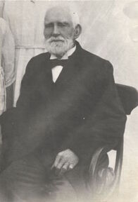
Photograph, James Venn Morgan, circa 1923, c. 1923
... James Venn Morgan suit the first house in Kew. This work... James Venn Morgan suit the first house in Kew. This work forms ...James Venn Morgan suit the first house in Kew. This work forms part of the collection assembled by the historian Dorothy Rogers, that was donated to the Kew Historical Society by her son John Rogers in 2015. The manuscripts, photographs, maps, and documents were sourced by her from both family and local collections or produced as references for her print publications. Many were directly used by Rogers in writing ‘Lovely Old Homes of Kew’ (1961) and 'A History of Kew' (1973), or the numerous articles on local history that she produced for suburban newspapers. Most of the photographs in the collection include detailed annotations in her hand.The Rogers Collection provides a comprehensive insight into the working habits of a historian in the 1960s and 1970s. Together it forms the largest privately-donated collection within the archives of the Kew Historical Society.Photograph of James Venn Morgan, probably taken on the occasion of his 100th birthday in 1923. He was one of the most important pioneers of Kew.James Venn Morgan about 100 years. Born Lancashire 1823.james venn morgan, dorothy rogers, kew -
 Kew Historical Society Inc
Photograph, Chipperfield's Boat House & Floating Pontoon, 1934
... sides of the River Yarra at Kew. Chipperfield's Boat House... sides of the River Yarra at Kew. Chipperfield's Boat House ...Living with natural processes was frequently a challenge to early European settlers and later residents of what was in the 1850s administered by the Borondara Road Board. This was compounded by the area being bounded on three sides by rivers (Yarra River, Koonung Creek and Gardiner's Creek). In 1849, the historian James Bonwick recorded that "our district [Kew] suffered considerably. Mr Wade speaks of 80 acres, out of 100 acres of his cultivated paddock, covered by water." Newspapers continued to describe major flooding in Kew in 1863, 1869, 1878, 1880, 1889, 1891, 1916 and 1934. While the construction of the Upper Yarra dam in 1957 reduced the levels of flowing downstream, local and riverine floods continue. A number of boat houses operated on both sides of the River Yarra at Kew. Chipperfield's Boat House was located on the Yarra near the corner of Kilby and Willsmere Roads.The Kew Historical Society's pictures and map collections testify to the impact of flooding in the district. They have historical importance in documenting the extent of flooding in the district and its affects on homes, services and recreation. Numerous photographs record flooding throughout the Twentieth Century.Floating pontoon at Chipperfield's Boat House where the canoes were stored, taken in 1934, presumably before the 1934 Flood. This area of the Yarra was shallow with a number of mid river sandbanks and a popular swimming area for locals.yarra river, chipperfield's boathouse, pontoon -
 Melbourne Legacy
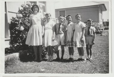
Photograph, Holiday 1961, 1961
... with the running of the camp at Blamey House in Kew and she donated... with the running of the camp at Blamey House in Kew and she donated ...A photo of a family of Junior Legatees in 1961. Legacy provided outings, camps and holidays for children all over Victoria. Country children would stay for two weeks in the city (often at the Legacy residences) and city children were billeted with families around Victoria. The names that accompanied this photo were: The Picone family from North Albury 1961. L-R Cheryl 14, Jenny 11, Antony 10, Leslie and Maria 9 and Alan 7. At the time Legatee Bert Davis was CFO, and his daughter Louise was asked to help with the running of the camp at Blamey House in Kew and she donated this photo.A record of outings and camps provided for junior legatees in the 1960s.Black and white photo of the Picone family from North Albury in 1961.camps, junior legatee outings, holidays -
 Kew Historical Society Inc
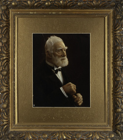
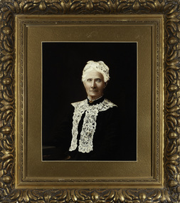
Photograph, James Venn Morgan, c.1905
... Mr. Morgan built the first house in Kew, and this house... Mr. Morgan built the first house in Kew, and this house ...James Venn Morgan was known affectionately as ‘The Father of Kew’. Born in Somersetshire on February 21, 1823, he sailed to Australia in April, 1851. James V. Morgan, was a member of one of the first parties to leave for the diggings. At Chewton, near Castlemaine his party tried their luck in an abandoned shaft, and in two weeks returned to Melbourne after having won 35lb weight of gold. James Venn Morgan was content with his success, and induced his partners to invest their money with him in land. After obtaining the advice of a friend, the party negotiated with Mr Samuel Watts, of Collingwood, who had recently purchased land from the Crown, and from him they took over at £15 an acre about 32 acres of land in the district that is now known as Kew. This land extended from where the Kew Post-office now stands to the locality of the Boroondara Cemetery. Here it was that Mr Morgan decided to settle, and, after having had the land surveyed, the partners apportioned it by drawing straws for the four sections into which it had been divided. One of them sold his holding later in the year for £100 an acre, and was sorry for it afterwards. In 1853 Mr. Morgan built the first house in Kew, and this house is the one in which he still resides. Here with his wife, he settled down to market gardening and dairying. So successful was the new venture that he induced his father and other members of the family to come out to Australia to assist him. Gradually the district became settled, Mr. Morgan parted with a portion of his holding, and subdivided and built on the remainder, which he still retained. In 1884 he found himself in a position to retire from active business.He celebrated his 100th birthday in 1923. He was later to die in the same year. The Argus, 17 January 1923.Rare and historic hand-tinted framed portrait of one of the founding pioneers of the district.Hand tinted photograph in a gilt frame of the Kew pioneer James Venn Morgan (1823-1923).james venn morgan, kew - pioneer families, kew - landowners -
 Kew Historical Society Inc
Photograph, Anna Morgan, c. 1905
... Mr. Morgan built the first house in Kew, and this house... Mr. Morgan built the first house in Kew, and this house ...James Venn Morgan was known affectionately as ‘The Father of Kew’. Born in Somersetshire on February 21, 1823, he sailed to Australia in April, 1851. James V. Morgan, was a member of one of the first parties to leave for the diggings. At Chewton, near Castlemaine his party tried their luck in an abandoned shaft, and in two weeks returned to Melbourne after having won 35lb weight of gold. James Venn Morgan was content with his success, and induced his partners to invest their money with him in land. After obtaining the advice of a friend, the party negotiated with Mr Samuel Watts, of Collingwood, who had recently purchased land from the Crown, and from him they took over at £15 an acre about 32 acres of land in the district that is now known as Kew. This land extended from where the Kew Post-office now stands to the locality of the Boroondara Cemetery. Here it was that Mr Morgan decided to settle, and, after having had the land surveyed, the partners apportioned it by drawing straws for the four sections into which it had been divided. One of them sold his holding later in the year for £100 an acre, and was sorry for it afterwards. In 1853 Mr. Morgan built the first house in Kew, and this house is the one in which he still resides. Here with his wife, he settled down to market gardening and dairying. So successful was the new venture that he induced his father and other members of the family to come out to Australia to assist him. Gradually the district became settled, Mr. Morgan parted with a portion of his holding, and subdivided and built on the remainder, which he still retained. In 1884 he found himself in a position to retire from active business. He celebrated his 100th birthday in 1923. He was later to die in the same year. The Argus, 17 January 1923.Rare and-tinted framed photograph af Annie Morgan, the wife of one of the founding pioneers of the district.Hand tinted photograph in a gilt frame of Anna Morgan (nee Chidgey), the wife of James Venn Morgan. Anna Morgan was the wife of one of Kew's earliest pioneers and landowners. She died in 1915.anna morgan, kew - pioneers -
 Melbourne Legacy
Photograph, Operation Float 1962, 1961
... House in Kew, while Junior Legatees from the city were billeted... for a two week summer camp, often at Blamey House in Kew, while ...A photo of a group of ladies in Williamstown for Operation Float in 1962. The lady second from left is Mrs Violet Allen who led the summer camps at Blamey House for many years. Operation Float was an opportunity for junior legatees to experience sailing or boating on Port Philip Bay, often organised while they were at a summer camp. Junior Legatees from the country were brought to the city for a two week summer camp, often at Blamey House in Kew, while Junior Legatees from the city were billeted with families in the country. At the time Legatee Bert Davis was CFO, and his daughter Louise was asked to help with the running of the Blamey House camp. Photos donated by Legatee Bert Davis' daughters.A record of outings, holidays and camps provided for Junior Legatees in the 1960s.Black and white photo of five ladies in a park.camps, blamey house, junior legatee outings, operation float -
Kew Historical Society Inc
Archive (collection) - Subject Files, Kew Historical Society, 1958-present
... in the Kew Library, and are housed in labelled, archivally sound... in the Kew Library, and are housed in labelled, archivally sound ...Various partiesReference, Research, InformationAlphabetic orderSubject Files have been created and compiled by members since 1958. The Files are defined as a Series. They include primary and secondary resources - newspaper and journal clippings, brochures, short histories of families and buildings, personal accounts, etc. - relating to people, places and events. The series as a whole is sorted alphabetically. Each component of the series is grouped by Secondary Values (the values of records to users) rather than by Primary Values (Provenance Order). There are approximately 500 separate Subject Files. While some files contain a small number of records, others contain numerous documents and manuscripts. The Subject Files are housed in four, four-drawer locked filing cabinets in the foyer of the Kew Heritage Centre in the Kew Library, and are housed in labelled, archivally sound folders.kew, boroondara, melbourne, victoriakew, boroondara, melbourne, victoria -
 Kew Historical Society Inc
Plan, Borough of Kew Detail Plan No.1577, 1904
... houses in Kew. Herbert Henty made his home here and was elected... includes some of the most significant houses in Kew: Herbert ...The Melbourne and Metropolitan Board of Works (MMBW) plans were produced from the 1890s to the 1950s. They were crucial to the design and development of Melbourne's sewerage and drainage system. The plans, at a scale of 40 feet to 1 inch (1:480), provide a detailed historical record of Melbourne streetscapes and environmental features. Each plan covers one or two street blocks (roughly six streets), showing details of buildings, including garden layouts and ownership boundaries, and features such as laneways, drains, bridges, parks, municipal boundaries and other prominent landmarks as they existed at the time each plan was produced. (Source: State Library of Victoria)This plan forms part of a large group of MMBW plans and maps that was donated to the Society by the Mr Poulter, City Engineer of the City of Kew in 1989. Within this collection, thirty-five hand-coloured plans, backed with linen, are of statewide significance as they include annotations that provide details of construction materials used in buildings in the first decade of the 20th century as well as additional information about land ownership and usage. The copies in the Public Record Office Victoria and the State Library of Victoria are monochrome versions which do not denote building materials so that the maps in this collection are invaluable and unique tools for researchers and heritage consultants. A number of the plans are not held in the collection of the State Library of Victoria so they have the additional attribute of rarity.Original survey plan, issued by the MMBW to a contractor with responsibility for constructing sewers in the area identified on the plan within the Borough of Kew. The plan was at some stage hand-coloured, possibly by the contractor, but more likely by officers working in the Engineering Department of the Borough and later Town, then City of Kew. The hand-coloured sections of buildings on the plan were used to denote masonry or brick constructions (pink), weatherboard constructions (yellow), and public buildings (grey). MMBW Plan No.1577 includes some of the most significant houses in Kew: Herbert Henty’s ‘Roxeth’ (now part of Trinity Grammar), ‘Butleigh Wooton’, ‘Bokara’ and ‘Harrow’. It also includes the streets that have since changed their names. That part of College Parade linked to Glenferrie Road is now named College Place, College Parade now extends further north, and Charles Street did not yet reach Barkers Road. Roxeth is one of a number of Henty houses in Kew. Herbert Henty made his home here and was elected a member of Kew Municipal Council in 1864 and mayor in 1868-69. Walter Henry Serle, of Harrow served in the First World War. He was awarded the Military Medal ‘’For conspicuous bravery and devotion to duty. On 29th September near BELLICOURT he showed the greatest bravery and determination when his platoon was attacked by enemy bombing parties. It was due largely to his personal efforts that all the attacks were repulsed. Until wounded, his utter disregard of personal safety and boldness in dealing with the attacks were the means of saving the situation and were an inspiring example to his men.’melbourne and metropolitan board of works, detail plans, maps - borough of kew, mmbw 1577, cartography -
 Melbourne Legacy
Photograph, Christmas Party 1974, 1974
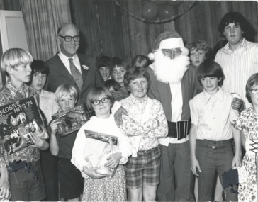
... Stanhope, Harelands or Blamey House - Kew) in 1974. Photo came from..., Harelands or Blamey House - Kew) in 1974. Photo came from a folder ...A photo of Santa and Melbourne Legacy President Bill Braidie with children and gifts in one the residences (either Stanhope, Harelands or Blamey House - Kew) in 1974. Photo came from a folder marked Residences. Melbourne Legacy ran residences to take care of children whose deceased father had been a serviceman and the mother was unable to care for them herself or the child needed to be in city for education reasons. The first was Holmbush which started in 1942. Then Stanhope in 1945, these were for older children for education or vocational opportunities. There was a need for a toddler/younger child home so Blamey House was established in Beaumaris in 1947 for 3 to 9 year olds. Harelands was acquired in 1950. Then the property in Beaumaris was sold and the name Blamey House was transferred to Holmbush, at 1267 Burke Road Kew from 1956 to 1978. For much of the time from late 1950s to 1970s Harelands accommodated boys and girls under the age of 14, Blamey House looked after boys over 14, and Stanhope looked after girls over 14. The children were cared for until they were old enough to become independent. Stanhope was closed in the late 1970s and when Blamey House (formerly Holmbush) was closed the name was again transferred, this time to Harelands from 1978 to 1981 when it was the last residence to be sold.A record of gifts for the children at the residences in 1974.Black and white photo of Junior Legatees with Santa and gifts at a residence in 1974.Handwritten 'P7 Legacy' in blue pen and '1974' in black penchristmas gifts, residences, bill braidie -
 Kew Historical Society Inc
Functional object - Wrought iron nails from 'Reno', St John's Parade, c. 1864
... Comparatively few weatherboard houses in Kew survived from... Comparatively few weatherboard houses in Kew survived from the early ...Comparatively few weatherboard houses in Kew survived from the early years of settlement into the second half of the 20th century. One such property was ‘Reno’, which once stood on the east side of St John’s Parade. Its earliest recorded owner was the architect Samuel Cocking who lived there from c.1865 until his death in 1888. The original landholding was bordered by Cotham Road, Glenferrie Road, Wellington Street, and Charles Street. The southern portion of this land included a fine orchard, with many imported trees. The old summer house, at first in the orchard, was later removed to the house garden. The MMBW Detail Plan No.1576 (1904) shows the remaining portion of the original land holding, including a semi-circular pathway at the front, and garden features such as an aviary, a fountain and grotto, and a fernery. None of these are apparent in photographs dating from the 1960s, where the garden, which once included rare plants provided by Baron Von Mueller, surrounds the cottage in a tangled frenzy. Despite a ‘local significance’ classification by the National Trust, the house was demolished in 1977.7 square headed iron nails collected from Reno before its demolition. In envelope marked with the name Joy Stewartreno, nails, samuel cocking -
![Wallpaper from 'Reno', St John's Parade [Kew]](/media/collectors/550653872162f11fb04854aa/items/57975996d0cdd1098c81d980/item-media/579759ded0cdd1098c81f6fa/item-fit-380x285.jpg) Kew Historical Society Inc
Kew Historical Society IncDecorative object - Wallpaper sample from 'Reno', St John's Parade, 1890s
... Comparatively few weatherboard houses in Kew survived from... Comparatively few weatherboard houses in Kew survived from the early ...Comparatively few weatherboard houses in Kew survived from the early years of settlement into the second half of the 20th century. One such property was ‘Reno’, which once stood on the east side of St John’s Parade. Its earliest recorded owner was the architect Samuel Cocking who lived there from c.1865 until his death in 1888. The original landholding was bordered by Cotham Road, Glenferrie Road, Wellington Street, and Charles Street. The southern portion of this land included a fine orchard, with many imported trees. The old summer house, at first in the orchard, was later removed to the house garden. The MMBW Detail Plan No.1576 (1904) shows the remaining portion of the original land holding, including a semi-circular pathway at the front, and garden features such as an aviary, a fountain and grotto, and a fernery. None of these are apparent in photographs dating from the 1960s, where the garden, which once included rare plants provided by Baron Von Mueller, surrounds the cottage in a tangled frenzy. Despite a ‘local significance’ classification by the National Trust, the house was demolished in 1977. Wallpaper fragment from ‘Reno’. This small fragment of floral wall paper is a bolder design than the delicately drawn flowers in 1977.0005.1. The flowers in this example were impressionistically created using printing blocks that allowed for different thicknesses of paint to be applied in the hand-blocking process. wallpaper, reno, st john's parade, kew -
![Wallpaper from 'Reno', St John's Parade [Kew]](/media/collectors/550653872162f11fb04854aa/items/57975a62d0cdd1098c8232a8/item-media/57975cabd0cdd1098c836f91/item-fit-380x285.jpg) Kew Historical Society Inc
Kew Historical Society IncDecorative object - Wallpaper sample from 'Reno', St John's Parade, 1870s
... Comparatively few weatherboard houses in Kew survived from... Comparatively few weatherboard houses in Kew survived from the early ...Comparatively few weatherboard houses in Kew survived from the early years of settlement into the second half of the 20th century. One such property was ‘Reno’, which once stood on the east side of St John’s Parade. Its earliest recorded owner was the architect Samuel Cocking who lived there from c.1865 until his death in 1888. The original landholding was bordered by Cotham Road, Glenferrie Road, Wellington Street, and Charles Street. The southern portion of this land included a fine orchard, with many imported trees. The old summer house, at first in the orchard, was later removed to the house garden. The MMBW Detail Plan No.1576 (1904) shows the remaining portion of the original land holding, including a semi-circular pathway at the front, and garden features such as an aviary, a fountain and grotto, and a fernery. None of these are apparent in photographs dating from the 1960s, where the garden, which once included rare plants provided by Baron Von Mueller, surrounds the cottage in a tangled frenzy. Despite a ‘local significance’ classification by the National Trust, the house was demolished in 1977.Wallpaper fragment from ‘Reno’. This large single example is interesting as it represents a change in fashion and style from the finely drawn flowers (1971.0002.1) of an older paper, parts of which can be seen behind this sample. Typically the updating of wallpapers was accomplished by laying a new paper over the old. The ‘newer’ wallpaper is of a single colour, the tone of which may have suffered from colour distortion due to ageing. The new block-printed design, featuring repeated sprays of flowers and leaves combines a bold use of colour with an elegance of design.reno, st john's parade, kew, samuel cocking, wallpaper -
![Wallpaper fragment - Reno, St John's Parade [Kew]](/media/collectors/550653872162f11fb04854aa/items/57975cd6d0cdd1098c838ddb/item-media/57975d42d0cdd1098c83c222/item-fit-380x285.jpg) Kew Historical Society Inc
Kew Historical Society IncDecorative object - Wallpaper sample from 'Reno', St John's Parade, 1870s
... Comparatively few weatherboard houses in Kew survived from... Comparatively few weatherboard houses in Kew survived from the early ...Comparatively few weatherboard houses in Kew survived from the early years of settlement into the second half of the 20th century. One such property was ‘Reno’, which once stood on the east side of St John’s Parade. Its earliest recorded owner was the architect Samuel Cocking who lived there from c.1865 until his death in 1888. The original landholding was bordered by Cotham Road, Glenferrie Road, Wellington Street, and Charles Street. The southern portion of this land included a fine orchard, with many imported trees. The old summer house, at first in the orchard, was later removed to the house garden. The MMBW Detail Plan No.1576 (1904) shows the remaining portion of the original land holding, including a semi-circular pathway at the front, and garden features such as an aviary, a fountain and grotto, and a fernery. None of these are apparent in photographs dating from the 1960s, where the garden, which once included rare plants provided by Baron Von Mueller, surrounds the cottage in a tangled frenzy. Despite a ‘local significance’ classification by the National Trust, the house was demolished in 1977. Wallpaper fragment from ‘Reno’. These three boldly designed samples from a single room are in shades of green and brown, highlighted by yellow and red floral sprays. While more accurately printed and coloured, the fragment lacks the freedom of design of the earlier samples.wallpaper, reno, st john's parade, kew, samuel cocking -
![Reno, St John's Parade [Kew] - Reno, St John's Parade [Kew]](/media/collectors/550653872162f11fb04854aa/items/57975dcbd0cdd1098c840aaf/item-media/57975e31d0cdd1098c84343d/item-fit-380x285.jpg) Kew Historical Society Inc
Kew Historical Society IncDecorative object - Wallpaper samples from 'Reno', St John's Parade, 1880-1910
... Comparatively few weatherboard houses in Kew survived from... Comparatively few weatherboard houses in Kew survived from the early ...Comparatively few weatherboard houses in Kew survived from the early years of settlement into the second half of the 20th century. One such property was ‘Reno’, which once stood on the east side of St John’s Parade. Its earliest recorded owner was the architect Samuel Cocking who lived there from c.1865 until his death in 1888. The original landholding was bordered by Cotham Road, Glenferrie Road, Wellington Street, and Charles Street. The southern portion of this land included a fine orchard, with many imported trees. The old summer house, at first in the orchard, was later removed to the house garden. The MMBW Detail Plan No.1576 (1904) shows the remaining portion of the original land holding, including a semi-circular pathway at the front, and garden features such as an aviary, a fountain and grotto, and a fernery. None of these are apparent in photographs dating from the 1960s, where the garden, which once included rare plants provided by Baron Von Mueller, surrounds the cottage in a tangled frenzy. Despite a ‘local significance’ classification by the National Trust, the house was demolished in 1977.Wallpaper fragment from ‘Reno’. These two large fragments of wallpaper have a formality of design that is accentuated by the wide borders and narrow vertical lines that separate the repeated designs of rose garlands in vases on a vertical trellis design. The design is in tones of pink and green with gilding.reno, st john's parade, kew, samuel cocking, wallpaper -
![Wallpaper from 'Reno', St John's Parade [Kew]](/media/collectors/550653872162f11fb04854aa/items/57975eabd0cdd1098c846619/item-media/57975ee7d0cdd1098c8484f7/item-fit-380x285.jpg) Kew Historical Society Inc
Kew Historical Society IncDecorative object - Wallpaper samples from 'Reno', St John's Parade, 1880-1914
... Comparatively few weatherboard houses in Kew survived from... Comparatively few weatherboard houses in Kew survived from the early ...Comparatively few weatherboard houses in Kew survived from the early years of settlement into the second half of the 20th century. One such property was ‘Reno’, which once stood on the east side of St John’s Parade. Its earliest recorded owner was the architect Samuel Cocking who lived there from c.1865 until his death in 1888. The original landholding was bordered by Cotham Road, Glenferrie Road, Wellington Street, and Charles Street. The southern portion of this land included a fine orchard, with many imported trees. The old summer house, at first in the orchard, was later removed to the house garden. The MMBW Detail Plan No.1576 (1904) shows the remaining portion of the original land holding, including a semi-circular pathway at the front, and garden features such as an aviary, a fountain and grotto, and a fernery. None of these are apparent in photographs dating from the 1960s, where the garden, which once included rare plants provided by Baron Von Mueller, surrounds the cottage in a tangled frenzy. Despite a ‘local significance’ classification by the National Trust, the house was demolished in 1977. Wallpaper fragment from ‘Reno’. This small fragment is part of the larger design shown in the previous sample (1971.0002.5). It includes a detail of the trellis element from the larger scheme.wallpaper, samuel cocking, reno, st john's parade, kew -
![Letter Plate, 'Reno', St John's Parade [Kew]](/media/collectors/550653872162f11fb04854aa/items/57a03863d0cdd1210435bac1/item-media/57a038b1d0cdd1210435f155/item-fit-380x285.jpg) Kew Historical Society Inc
Kew Historical Society IncFunctional object - Letter Plate, 'Reno', St John's Parade, c.1900
... Comparatively few weatherboard houses in Kew survived from... Comparatively few weatherboard houses in Kew survived from the early ...Comparatively few weatherboard houses in Kew survived from the early years of settlement into the second half of the 20th century. One such property was ‘Reno’, which once stood on the east side of St John’s Parade. Its earliest recorded owner was the architect Samuel Cocking who lived there from c.1865 until his death in 1888. The original landholding was bordered by Cotham Road, Glenferrie Road, Wellington Street, and Charles Street. The southern portion of this land included a fine orchard, with many imported trees. The old summer house, at first in the orchard, was later removed to the house garden. The MMBW Detail Plan No.1576 (1904) shows the remaining portion of the original land holding, including a semi-circular pathway at the front, and garden features such as an aviary, a fountain and grotto, and a fernery. None of these are apparent in photographs dating from the 1960s, where the garden, which once included rare plants provided by Baron Von Mueller, surrounds the cottage in a tangled frenzy. Despite a ‘local significance’ classification by the National Trust, the house was demolished in 1977.Brass letter plate, originally from the front door of Reno in St John's Parade, Kew. Donated by Miss McDowell in 1977, in the year the house was demolished.reno, st john's parade, kew -
![Wallpaper sample from 'Reno', St John's Parade [Kew]](/media/collectors/550653872162f11fb04854aa/items/5670dfde2162f10b54fac48a/item-media/5797600bd0cdd1098c854c29/item-fit-380x285.jpg) Kew Historical Society Inc
Kew Historical Society IncDecorative object - Wallpaper sample from 'Reno', St John's Parade, 1850-1880
... Comparatively few weatherboard houses in Kew survived from... Comparatively few weatherboard houses in Kew survived from the early ...Comparatively few weatherboard houses in Kew survived from the early years of settlement into the second half of the 20th century. One such property was ‘Reno’, which once stood on the east side of St John’s Parade. Its earliest recorded owner was the architect Samuel Cocking who lived there from c.1865 until his death in 1888. The original landholding was bordered by Cotham Road, Glenferrie Road, Wellington Street, and Charles Street. The southern portion of this land included a fine orchard, with many imported trees. The old summer house, at first in the orchard, was later removed to the house garden. The MMBW Detail Plan No.1576 (1904) shows the remaining portion of the original land holding, including a semi-circular pathway at the front, and garden features such as an aviary, a fountain and grotto, and a fernery. None of these are apparent in photographs dating from the 1960s, where the garden, which once included rare plants provided by Baron Von Mueller, surrounds the cottage in a tangled frenzy. Despite a ‘local significance’ classification by the National Trust, the house was demolished in 1977.Original sample of nineteenth century wallpaper from one of the earliest homes in Kew (Victoria).Wallpaper fragment from ‘Reno’. These two samples of light brown Victorian-period wallpaper were overprinted with flowers and leaves that are outlined in maroon. Flowers and foliage are painted in blue of varying intensity, giving the impression of being hand painted. The style of this wallpaper would have been suited to a bedroom or drawing room.wallpaper, samuel cocking, reno, st john's parade, kew -
 Kew Historical Society Inc
Plan, Melbourne & Metropolitan Board of Works : Borough of Kew : Detail Plan No.1564, 1905
... larger blocks than in Central Kew. Many of the houses... of the Borough and later Town, then City of Kew. The hand-coloured ...The Melbourne and Metropolitan Board of Works (MMBW) plans were produced from the 1890s to the 1950s. They were crucial to the design and development of Melbourne's sewerage and drainage system. The plans, at a scale of 40 feet to 1 inch (1:480), provide a detailed historical record of Melbourne streetscapes and environmental features. Each plan covers one or two street blocks (roughly six streets), showing details of buildings, including garden layouts and ownership boundaries, and features such as laneways, drains, bridges, parks, municipal boundaries and other prominent landmarks as they existed at the time each plan was produced. (Source: State Library of Victoria)This plan forms part of a large group of MMBW plans and maps that was donated to the Society by the Mr Poulter, City Engineer of the City of Kew in 1989. Within this collection, thirty-five hand-coloured plans, backed with linen, are of statewide significance as they include annotations that provide details of construction materials used in buildings in the first decade of the 20th century as well as additional information about land ownership and usage. The copies in the Public Record Office Victoria and the State Library of Victoria are monochrome versions which do not denote building materials so that the maps in this collection are invaluable and unique tools for researchers and heritage consultants. A number of the plans are not held in the collection of the State Library of Victoria so they have the additional attribute of rarity.Original survey plan, issued by the MMBW to a contractor with responsibility for constructing sewers in the area identified on the plan within the Borough of Kew. The plan was at some stage hand-coloured, possibly by the contractor, but more likely by officers working in the Engineering Department of the Borough and later Town, then City of Kew. The hand-coloured sections of buildings on the plan were used to denote masonry or brick constructions (pink), weatherboard constructions (yellow), and public buildings (grey). In 1905, when Plan No.1564 was printed, that part of Kew bordered by Brougham Place (now Daniell Place), Mount Street, Sackville Street and Ross Street was already the location of a number of large mansions. Here, subdivisions, at least at this stage, produced larger blocks than in Central Kew. Many of the houses on this plan are named: ‘Faybrook’, ‘Northumbria’, ‘Parkholm[e]’, ‘Dunboe’, ‘Katoomba’ and ‘Eschol’ fronting Sackville Street. Eschol was once the home of the manufacturer Robert Harrison, whose cordial factory in Spring and Argyle Streets Fitzroy are noted on the Victorian Heritage Register. ‘The Hawthorns’ on the corner of Brougham Place and Mount Street was the home of the medical practitioner Frank William Fay, who won the military cross and other honours for conspicuous gallantry and devotion to duty in World War 1.melbourne and metropolitan board of works, detail plans, mmbw 1564, cartography -
 Kew Historical Society Inc
Plan, Melbourne & Metropolitan Board of Works : Borough of Kew : Detail Plan No.1570, 1905
... delineated in Plan No.1563. Kylemore is one of the few houses in Kew... of the few houses in Kew designed by John Beswicke. The most notable ...The Melbourne and Metropolitan Board of Works (MMBW) plans were produced from the 1890s to the 1950s. They were crucial to the design and development of Melbourne's sewerage and drainage system. The plans, at a scale of 40 feet to 1 inch (1:480), provide a detailed historical record of Melbourne streetscapes and environmental features. Each plan covers one or two street blocks (roughly six streets), showing details of buildings, including garden layouts and ownership boundaries, and features such as laneways, drains, bridges, parks, municipal boundaries and other prominent landmarks as they existed at the time each plan was produced. (Source: State Library of Victoria)This plan forms part of a large group of MMBW plans and maps that was donated to the Society by the Mr Poulter, City Engineer of the City of Kew in 1989. Within this collection, thirty-five hand-coloured plans, backed with linen, are of statewide significance as they include annotations that provide details of construction materials used in buildings in the first decade of the 20th century as well as additional information about land ownership and usage. The copies in the Public Record Office Victoria and the State Library of Victoria are monochrome versions which do not denote building materials so that the maps in this collection are invaluable and unique tools for researchers and heritage consultants. A number of the plans are not held in the collection of the State Library of Victoria so they have the additional attribute of rarity.Original survey plan, issued by the MMBW to a contractor with responsibility for constructing sewers in the area identified on the plan within the Borough of Kew. The plan was at some stage hand-coloured, possibly by the contractor, but more likely by officers working in the Engineering Department of the Borough and later Town, then City of Kew. The hand-coloured sections of buildings on the plan were used to denote masonry or brick constructions (pink), weatherboard constructions (yellow), and public buildings (grey). Plan No.1570 shows the layout of gardens and houses in Sackville Street, Davis Street, Wrixon Street, and Fitzwilliam Street in 1904. While Thomas Street is included on the map, at this stage no houses had been built. The plan identifies two named houses: ‘Fairview’ and ‘Kylemore’. Fairview is more fully delineated in Plan No.1563. Kylemore is one of the few houses in Kew designed by John Beswicke. The most notable owner of Kylemore was William Whitehead, who owned the house between 1895 and 1900. In 1894, Australian newspapers reported the marriage of Whitehead’s daughter to Dr. Gerald Eugene Cussen, the brother of Sir Leo Cussen, the Supreme Court Judge. The married couple was to live at ‘Wilton’ (now the Kew RSL) from 1911-15.melbourne and metropolitan board of works, detail plans, mmbw 1570, cartography -
 Kew Historical Society Inc
Photograph - 'Wimba', Cotham Road, J E & B L Rogers, c.1965
... century houses of Kew and for remaining in a substantially intact... houses of Kew and for remaining in a substantially intact state ...'Wimba' is of significance as one of the key nineteenth century houses of Kew and for remaining in a substantially intact state. Although probably built some time earlier, the first mention in the Rate Books of the property later known as 'Wimba Lodge' appears in the entry for 1870 when the property, owned by John Sharpe Denbigh, a civil servant, was given an N.A.V. of £72 2. Denbigh did however occupy a house in Cotham Road in 1863, and it is possible that was the same premises'. The house was occupied by Denbigh until at least May 1876 when the 'family residence...' \ 'as auctioned to Carlington George Edmund Marston 5, a chemist of Smith Street, Collingwood. At the time of the auction the house was described thus: The residence and grounds of the late J.S. Dendigh, situate in the most elevated part of Cotham Road Kew. The grounds comprise an area of 4a Or29p or thereabouts, and have a frontage to Cotham-road of 4 chains. The house has two large rooms in front, with 6ft hall built of brick, bay and side windows (plate glass), four rooms of wood behind with slate roofs, bathroom and closets, detached kitchen and servant's room, large shed with washing boiler, pantry and cellar under, brick and cement tank, and the Yan Yean laid onto house and grounds, cowshed, pigstye, &c, the whole securely fenced. First class orchard and flower garden. The paddocks laid with English grasses and drained... .' (Sanderson P, City of Kew Urban Conservation Study, Volume 2, 1988)This work forms part of the collection assembled by the historian Dorothy Rogers, that was donated to the Kew Historical Society by her son John Rogers in 2015. The manuscripts, photographs, maps, and documents were sourced by her from both family and local collections or produced as references for her print publications. Many were directly used by Rogers in writing ‘Lovely Old Homes of Kew’ (1961) and 'A History of Kew' (1973), or the numerous articles on local history that she produced for suburban newspapers. Most of the photographs in the collection include detailed annotations in her hand. The Rogers Collection provides a comprehensive insight into the working habits of a historian in the 1960s and 1970s. Together it forms the largest privately-donated collection within the archives of the Kew Historical Society.The front entrance of Wimba in Cotham Road, Kew. The entrance is flanked by two polygonal bay windows, and a verandah with a concave corrugated iron roof returns around three facades, and accentuates the projections of the windows. The solid render parapet is very ornate and tall for the date of construction. It has panels of decoration along it and is surmounted by a number of render urns. The image was used by Dorothy Rogers in 'A History of Kew' (1973), facing page 144.Wimba ca. 1860 built by J.S. Denbigh (has been altered).wimba, kew, dorothy rogers -
 Kew Historical Society Inc
Plan, Melbourne & Metropolitan Board of Works : Borough of Kew : Detail Plan No.1576, 1904
... of the most historic houses in Kew: ‘Ordsall’ (later ‘Southesk... the Borough of Kew. The plan was at some stage hand-coloured, possibly ...The Melbourne and Metropolitan Board of Works (MMBW) plans were produced from the 1890s to the 1950s. They were crucial to the design and development of Melbourne's sewerage and drainage system. The plans, at a scale of 40 feet to 1 inch (1:480), provide a detailed historical record of Melbourne streetscapes and environmental features. Each plan covers one or two street blocks (roughly six streets), showing details of buildings, including garden layouts and ownership boundaries, and features such as laneways, drains, bridges, parks, municipal boundaries and other prominent landmarks as they existed at the time each plan was produced. (Source: State Library of Victoria)This plan forms part of a large group of MMBW plans and maps that was donated to the Society by the Mr Poulter, City Engineer of the City of Kew in 1989. Within this collection, thirty-five hand-coloured plans, backed with linen, are of statewide significance as they include annotations that provide details of construction materials used in buildings in the first decade of the 20th century as well as additional information about land ownership and usage. The copies in the Public Record Office Victoria and the State Library of Victoria are monochrome versions which do not denote building materials so that the maps in this collection are invaluable and unique tools for researchers and heritage consultants. A number of the plans are not held in the collection of the State Library of Victoria so they have the additional attribute of rarity.Original survey plan, issued by the MMBW to a contractor with responsibility for constructing sewers in the area identified on the plan within the Borough of Kew. The plan was at some stage hand-coloured, possibly by the contractor, but more likely by officers working in the Engineering Department of the Borough and later Town, then City of Kew. The hand-coloured sections of buildings on the plan were used to denote masonry or brick constructions (pink), weatherboard constructions (yellow), and public buildings (grey). Development in the 20th century has irreparably altered that part of Kew represented in this plan. In the block bounded by Cotham Road, Charles Street, Wellington Street and Gellibrand; just one house standing in 1903 remains. This block included two of the most historic houses in Kew: ‘Ordsall’ (later ‘Southesk’) and ‘Madford’ (previously ‘Elm Lodge’). Ordsall was the home of the second chairman of Kew, John Halfey. It contained some of the most significant interior murals in Kew, created for Halfey by artists working for Cullen & Co. It was demolished in 1960 to make way for the Kew Civic Centre. Elm Lodge had been built for William Siddeley in ca. 1864. Arthur Septimus King purchased it in 1874. The lower paddocks of Madford were sold in 1905 by his wife to the Borough of Kew and, after landscaping by George and Thomas Pockett, opened as the Alexandra Gardens in 1908. Elm Lodge/Madford was in 1922 to become St. Anthony’s Home for Little Children before its subsequent demolition in the 1980s.melbourne and metropolitan board of works, detail plans, maps - borough of kew, mmbw 1576, cartography -
 Kew Historical Society Inc
Album - Photographs of heritage sites in Victoria, Eva Grant, 1964-66
... of first Government House. | Kew (Vic.) - Cairn at Dight’s Falls... House. | Kew (Vic.) - Cairn at Dight’s Falls; Canoe tree ...Eva Grant was a member of the Kew Historical Society. Three albums in the collection were created by her, this one, the third created between 1964 and 1966. They were donated to the Society by her daughter in 2010. Each of the albums includes photographs and newspaper cuttings collected on her travels to historic places in South East Australia in the 1950s and 1960s. Particular structures photographed in this album include: Barnawatha (Vic.) - The Hermitage | Beveridge (Vic.) - Stone cottage where Ned Kelly was born. | Brighton - St Andrew’s Church graveyard. | Chiltern (Vic.) - lake view [missing] | Cowes (Vic.) - ‘Broadwater’ [originally home of Henty-Wilson family], demolished 1965; Bell of the Speke wreck; Edward’s tree. | Euroa (Vic.) - Habbies Howe | Fairfield (Vic.) - Dight’s Falls; John Dight. | Fernshawe (Vic.) - Queen Mary tree. | Jolimont (Vic.) - Old railway tunnel linking the first Government House (1964); Sign identifying location of first Government House. | Kew (Vic.) - Cairn at Dight’s Falls; Canoe tree, Bowyer Avenue. | Kyneton - De Grave’s Flour Mill - “C”. | Maldon (Vic.) - Chinese oven; Macarthur’s House; Maldon’s oldest resident; Chinese graves x 2; [Beehive Chimney]. | Marysville (Vic.) - Centenary cairn | Mitcham (Vic.), Mud brick house x 2, Deep Creek Road. | Melbourne (Vic.) - St Paul’s Cathedral [renovation] (1964); Wreckers at Damman’s Corner, cnr Bourke and Collins Streets (1964); Princess Gate project x 2 (1964); Colonial Storekeeper’s building on cnr King and Bourke Streets (1966); Early observatory 1861-3; the Honey Memorial. | Mt Oberon (Vic.) - [obsolete] radio telephone dish. | Seymour (Vic.) - Habres (sic) House x 3.| Swan Hill (Vic.) - Major Mitchell’s Cairn (12/1964); Headstone of Andrew Beverage AM (12/1964). | Templestowe (Vic.) - Finn’s Hotel. | Thornton (Vic.) - Eildon Station. | Werribee (Vic.) - Chirnside Memorial [Presbyterian] Church; gaslight beside church | Location unknown, but possibly Swan Hill - Brick house; Wooden bullock dray. | Location unknown - Headstone of John Furlonge 1835.Important record of significant heritage properties in Victoria, many of which have since been demolished.30 page spirex bound drawing book including photographs and newspaper articles of historic buildings in Victoria. The front cover has a picture of a steam boat. The cover is encased in plastic. A number items in the album are annotated with written commentary by Eva Grant who compiled the album. Annotations and transcriptions by Eva Grant on most imageseva grant, photograph albums, heritage places - victoria